
Map of Türkiye, Asia, 1821
25,00 €Map of Türkiye, Asia It is a watercolour copper engraving dating back to 1821.
This small geographical map measures approximately 9x9 cm on a sheet of 13x15 cm.
- Back: White
- Taken from: French text from 1821
- Condition: Excellent condition

Map of Flanders, 1614
Map of Flanders it is a precious engraving made by Sebastian Munster in 1614, taken from his famous work Cosmography Universalis.
This map features Flanders, a historical region of Belgium, and is notable for its detailed geographical representation.
- Sheet size: cm. 36×22 approx.
- Image size: cm. 11,5×15 approx.
- Support: Watercolored laid paper
- Condition: Excellent state of preservation

Map of the islands of America, 1821
25,00 €Mappa delle isole dell’America è un’incisione in rame acquarellata realizzata nel 1821.
Questa piccola carta geografica, di dimensioni contenute, offre una rappresentazione dettagliata delle isole americane, ed è tratta da un testo francese dell’epoca.
- Sheet size: cm. 13×15 approx.
- Engraving size: cm. 9×9 approx.
- Support: Paper
- Condition: Excellent state of preservation
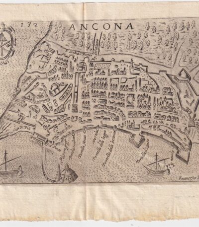
Map of Ancona, Scotus, 1659
90,00 €Map of Ancona it is a copper engraving made in 1659 by Francesco Scoto.
This map is part of the work Itinerary of Italy, published in Padua by Matteo Cadorino.
- Sheet size: cm. 16×20 approx.
- Engraving size: cm. 12×17 approx.
- Support: Light laid paper
- Condition: Excellent state of preservation
- Fold: Editorial fold
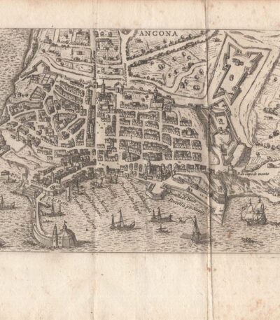
Map of Ancona, Scotus, 1761
90,00 €Map of Ancona it is an engraving made by Francesco Scotto in 1761.
This map is taken from the work Itinerary of Italy, published in Rome in 1761, at the expense of Fausto Amidei, Book Merchant.
- Sheet size: cm. 18×23 approx.
- Engraving size: cm. 12×18 approx.
- Support: Laid paper
- Condition: Excellent state of preservation
- Characteristic: Editorial fold

Mappa di Bologna, Scoto, 1761
90,00 €Mappa di Bologna it is a copper engraving made by Francesco Scotto in 1761.
This map is taken from the work Itinerary of Italy, published in Rome by Fausto Amidei, Book Merchant.
- Sheet size: cm. 18×23 approx.
- Engraving size: cm. 12×18 approx.
- Support: Laid paper
- Condition: Excellent condition
- Folds: Editorials

Map of Brescia, 1873
25,00 €Map of Brescia It is a copper engraving made in 1873.
This map is taken from the Guide in Italy, edited by Cav. PE Sacchi and published by the Artaria company of Milan.
On the back there is a white background, while on the side there is a legend of the most important sites of the city.
- Sheet size: cm. 15.5x9.5 approx.
- Condition: Excellent condition
- Support: Paper

Map of Cales, 1614
Map of Cales It is a page extracted from the Cosmography Universalis, created by Sebastian Munster in 1614.
This view of Cales, located in France, was colored in watercolor, while the reverse features a view of the city of Artois.
- Sheet size: cm. 36×22 approx.
- Image size: cm. 12×15,5 approx.
- Support: Laid paper
- Condition: Excellent state of preservation

Map of Civitavecchia, Scotus, 1761
90,00 €Mappa di Civitavecchia it is a copper engraving made by Francesco Scotto in 1761.
This map is taken from the work Itinerary of Italy, pubblicata a Roma da Fausto Amidei, mercante di libri.
- Sheet size: cm. 18×23 approx.
- Engraving size: cm. 12×18 approx.
- Support: Laid paper
- Condition: Excellent state of preservation
- Folds: Present
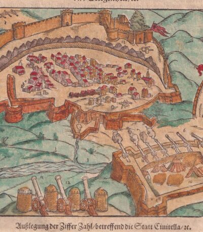
Map of Civitella, Abruzzi, 1614
Map of Civitella, Abruzzi It is a woodcut made by Sebastian Munster in 1614, taken from his famous work Cosmography Universalis.
This view represents Civitella del Tronto, located in the province of Teramo, in Abruzzo. On the back there is another image.
- Sheet size: cm. 36×22 approx.
- Image size: cm. 12.5x15.5 approx.
- Support: Watercolored laid paper
- Condition: Excellent state of preservation

Map of Estampes, 1614
Map of Estampes it is a valuable woodcut made by Sebastian Munster in 1614, taken from his famous work Cosmography Universalis.
This map provides a detailed view of the city of Estampes (Etampes) in France, highlighting the geographical and historical importance of the region.
- Sheet size: cm. 36×22 approx.
- Image size: cm. 10×18 approx.
- Support: Watercolored laid paper
- Condition: Excellent state of preservation
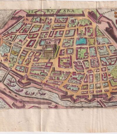
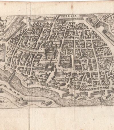
Map of Ferrara, Scotus, 1659
120,00 €Mappa di Ferrara it is a watercolour copper engraving made by Francesco Scoto in 1659.
This map is part of the work Itinerary of Italy, published in Padua by Matteo Cadorino.
- Sheet size: cm. 16×20 approx.
- Engraving size: cm. 12×17 approx.
- Support: Light laid paper
- Condition: Excellent state of preservation
- Fold: Editorale
Map of Ferrara, Scotus, 1761
90,00 €Mappa di Ferrara It is a copper engraving made in 1761 from Francesco Scotto.
This map is taken from the work Itinerary of Italy, pubblicata a Roma da Fausto Amidei, mercante di libri.
- Sheet size: cm. 18×23 approx.
- Engraving size: cm. 12×18 approx.
- Support: Laid paper
- Condition: Excellent condition
- Folds: Editorials
Mappa di Firenze, 1873
30,00 €Mappa di Firenze è un’incisione su rame realizzata da P. Allodi nel 1873.
This map is taken from the publication Guide in Italy, curata dal cav. P.E. Sacchi e stampata dalla ditta Artaria di Milano.
- Sheet size: cm. 15.5x20.5 approx.
- Support: Paper
- Condition: Excellent condition
- Notes: White back with legend of the most important sites of the city, features an editorial fold.

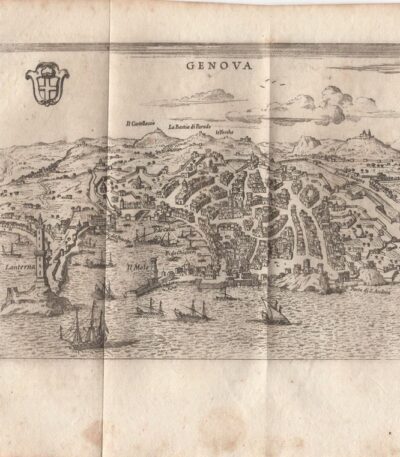
Mappa di Genova, 1873
30,00 €Mappa di Genova It is a copper engraving made in 1873 da P. Allodi.
Questa mappa è parte della pubblicazione Guide in Italy, curata dal cav. P.E. Sacchi e stampata dalla ditta Artaria di Milano.
- Sheet size: cm. 15.5x20.5 approx.
- Support: Paper
- Condition: Excellent condition
- Characteristics: Retro bianco con legenda dei siti più importanti della città, presenta una piega editoriale
Mappa di Genova, Scoto, 1761
90,00 €Mappa di Genova it is a copper engraving made in 1761 by Francesco Scotto.
This map is part of the work Itinerary of Italy, pubblicata a Roma da Fausto Amidei, mercante di libri.
- Sheet size: cm. 18×23 approx.
- Engraving size: cm. 12×18 approx.
- Support: Laid paper
- Condition: Excellent state of preservation

Map of Gravelines, France, 1614
Map of Gravelines, France it is a valuable engraving made by Sebastian Munster in 1614, taken from his famous work Cosmography Universalis.
This map offers a detailed view of Gravelines (Gravelingen), coloured in watercolour, with a view of Sancerra on the reverse.
- Sheet size: cm. 36×22 approx.
- Image size: cm. 12×15,5 approx.
- Support: Watercolored laid paper
- Condition: Excellent state of preservation

Map of Haarlem, 1614
Mappa di Haarlem it is a precious engraving made by Sebastian Munster in 1614, taken from his famous work Cosmography Universalis.
Questa mappa colorata rappresenta la città di Haarlem, situata nei Paesi Bassi, e offre una visione dettagliata della sua geografia e architettura. Il retro della mappa presenta scritte che ne attestano l’autenticità e la provenienza.
- Sheet size: cm. 36×22 approx.
- Image size: cm. 8×13 approx.
- Support: Watercolored laid paper
- Condition: Excellent state of preservation

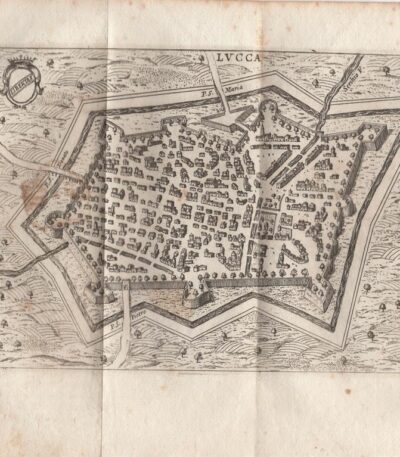
Map of Lucca, Scotus, 1659
90,00 €Map of Lucca it is a copper engraving made by Francesco Scoto in 1659.
This map is part of the work Itinerary of Italy, published in Padua by Matteo Cadorino.
- Sheet size: cm. 16×20 approx.
- Engraving size: cm. 12×17 approx.
- Support: Light laid paper
- Condition: Excellent condition
Map of Lucca, Scotus, 1761
90,00 €Map of Lucca it is a copper engraving made in 1761 by Francesco Scotto.
This map is part of the work Itinerary of Italy, published in Rome by Fausto Amidei, Book Merchant.
- Sheet size: cm. 18×23 approx.
- Engraving size: cm. 12×18 approx.
- Support: Laid paper
- Condition: Excellent condition

Map of Mantua, 1873
25,00 €Map of Mantua It is a copper engraving made in 1873.
This map is taken from the publication Guide in Italy, edited by Cav. PE Sacchi and published by the Artaria company of Milan.
- Sheet size: cm. 15.5x9.5 approx.
- Support: Paper
- Condition: Excellent condition
- Characteristics: White back with legend of the most important sites of the city

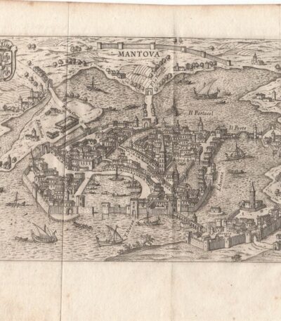
Map of Mantua, Scoto, 1659
120,00 €Map of Mantua It is a watercolour copper engraving made in 1659 by Francis Scotus.
This map is part of the work Itinerary of Italy, published in Padua by Matteo Cadorino.
- Sheet size: cm. 16×20 approx.
- Engraving size: cm. 12×17 approx.
- Support: Light laid paper
- Condition: Excellent condition
Map of Mantua, Scoto, 1761
90,00 €Map of Mantua it is a copper engraving made in 1761 by Francesco Scotto.
This map is part of the work Itinerary of Italy, published in Rome at the expense of Fausto Amidei, Book Merchant.
- Sheet size: cm. 18×23 approx.
- Engraving size: cm. 12×18 approx.
- Support: Laid paper
- Condition: Excellent state of preservation
- Folds: Editorials

Map of Modena, 1873
25,00 €Mappa di Modena It is an engraving made in 1873, part of the publication Guide in Italy a cura del cav. P.E. Sacchi, edita dalla ditta Artaria di Milano.
Questa mappa offre una rappresentazione dettagliata della città di Modena, rendendola un prezioso documento storico.
- Sheet size: cm. 15.5x9.5 approx.
- Support: Paper
- Condition: Excellent condition
