Germany
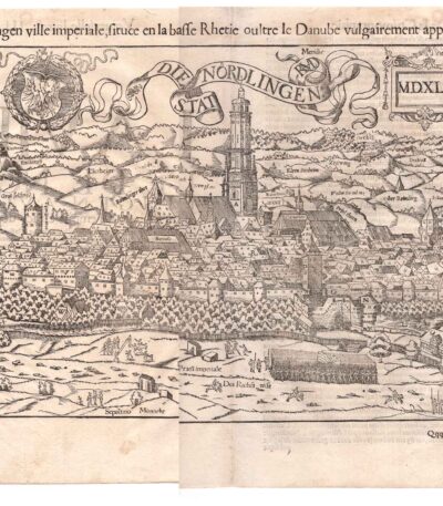
Antica mappa di Nördlingen Germania Cosmographia Universalis Kandel 1556
90,00 €Nördlingen ville imperial… Mappa a volo d’uccello della città di Nordlingen, di Sebastian Münster, 1556
Rara veduta xilografica della città imperiale nel XVI secolo
Questa antica mappa xilografica mostra un’impressionante veduta a volo d’uccello della città imperiale di Nördlingen in Svevia, Baviera. Apparve nel 1556 nell’edizione francese della Cosmographia di Sebastian Münster.
La mappa raffigura la città medievale con le sue mura, le torri, le chiese e le file di case densamente edificate. Come importante centro commerciale del Sacro Romano Impero, Nördlingen è qui raffigurata in modo molto dettagliato.
In alto il monogramma RMD di Hans Rudolph Manuel Deutsch (1525-1571), grande cartografo e incisore tedesco.
Misura del foglio circa 39 x 30 cm misura della Immagine: circa 33,5 x 22,5 cm
Condizione: Molto buone. Con piega centrale editoriale. Foglio pulito con buona inchiostratura.

Bavaria, St.Munster, 1614
Bavaria, St.Munster, 1614 è una veduta affascinante della Baviera, estratta dalla celebre Cosmography Universalis by Sebastian Munster.
Questa xilografia, realizzata su carta vergellata acquarellata, offre uno sguardo dettagliato sulla regione nel 1614. Sul retro, sono presenti altre immagini che arricchiscono ulteriormente l’opera.
- Sheet size: cm. 36×22 approx.
- Image size: cm. 7×13 approx.
- Support: Watercolored laid paper
- Condition: Excellent

Brunswick, St. Munster, 1614
Brunswick, St. Munster, 1614 is a historical view of the city of Braunschweig, located in Lower Saxony, Germany.
This engraving is taken from the famous work Cosmography Universalis by Sebastian Munster, published in Basel in 1614.
- Sheet size: cm. 36×22 approx.
- Engraving size: cm. 12.5×15 approx.
- Support: Laid paper
- Condition: Excellent state of preservation

Cellarius, Germany, 1701
60,00 €Cellarius, Germany, 1701 It is a copper engraving representing a detailed map, taken from Notitia Orbis Antiqui sive Geographia Plenior by Christophorus Cellarius, published in 1701.
This work offers a fascinating insight into the geography of the period, making it a valuable piece for collectors and history buffs.
- Sheet size: cm. 24×33 approx.
- Engraving size: cm. 20×30 approx.
- Support: Paper
- Condition: Excellent state of preservation

Northern Germany, Otto Petri, 1853
50,00 €Northern Germany It is a detailed map of Northern Germany (Noord Duitschland), made by Otto Petri in 1853.
This engraving is hand colored and is part of the School Atlas Alle Deelen Der Aarde, published by J. Van Den Bosch in Rotterdam.
- Sheet size: cm. 26×34 approx.
- Map dimensions: cm. 22×27 approx.
- Support: Medium thickness paper
- Condition: Excellent condition, with editorial fold and white back

Germany, CF Delamarche, 1816
70,00 €Germany It is a historical map made by CF Delamarche in 1816, which represents Germany divided into zones, including the Bohemian states.
This copper engraving is colored around the outline and is taken from the volume Petit Atlas Moderne ou Collection de Cartes Elementaires, dedicated to youth and published in Paris by Delamarche.
- Sheet size: cm. 21×27
- Condition: Good condition, with some peeling and a central editorial crease
- Support: Paper

Ingelheim, St.Munster, 1614
Ingelheim, St.Munster, 1614 It is a watercolour woodcut representing a view of Ingelheim, taken from the famous work Cosmography Universalis by Sebastian Munster.
This page, published in Basel in 1614, offers a fascinating look at the city of Ingelheim, with accurate details and a back enriched with additional images.
- Sheet size: cm. 36×22 approx.
- Image size: cm. 9×12,5 approx.
- Support: Laid paper
- Condition: Excellent

Magdenburg and Aldenburg. S. Munster, 1614
Magdenburg and Aldenburg It is a historical view made by Sebastian Munster in 1614, extracted from his famous work Cosmography Universalis.
This engraving features maps of Magdenburg and Aldenburg Oldenburg, depicted on a single page on the recto and verso.
- Sheet size: cm. 36×22 approx.
- Image size: cm. 12.5×15 approx.
- Support: Watercolored laid paper
- Condition: Excellent state of preservation

Map of Germany, 1869
60,00 €Map of Germany è una litografia acquarellata del 1869, che rappresenta in modo dettagliato il territorio tedesco.
This map is taken from the volume Hand – Und Schulatlas uber alle Theile Der Erde, and is characterized by an editorial fold.
- Sheet size: mm. 437×347
- Support: Strong paper
- Condition: Excellent condition
- Back: White

Map of Germany, 1869
60,00 €Map of Germany It is a watercolour lithograph made in 1869, which offers a detailed representation of the German territory.
This map is taken from the volume Hand – Und Schulatlas über alle Teile Der Erde, a reference work of the time.
- Sheet size: mm. 437×347
- Support: Strong paper
- Condition: Excellent condition
- Characteristics: White back, editorial fold

Map of Germany, 1869
60,00 €Map of Germany it is a precious one chromolithography built in 1869.
This map, part of the volume Hand – Und Schulatlas uber alle Theile Der Erde, features accurate details and vivid coloring.
- Sheet size: mm. 437×347
- Condition: Excellent
- Support: Strong paper, white back
- Characteristics: Editorial fold

Map of Sweden, Russia, Germany, Poland and Denmark, 1760
40,00 €A new and compleat map of the parts of Sweden, Russia, Germany, Poland and Denmark, bordering on the Baltick Sea è una mappa storica pubblicata nel 1760 da J. Hinton a Newgate Street, Londra.
L’opera raffigura con dettagliata precisione le regioni che circondano il Mar Baltico, includendo Svezia, Russia, Germania, Polonia e Danimarca, e rappresenta un esempio significativo della cartografia settecentesca britannica, realizzata in un periodo di crescente interesse per l’espansione geografica e politica.
- Era: 18th century
- Technique: Copper engraving
- Dimensions: Grandi (28×34 cm, senza margini)
- Support: Paper
- Condition: Buone (nota: assenza della cornice laterale)
Questa mappa è un’importante testimonianza storica che combina arte e scienza, rappresentando un’opportunità preziosa per collezionisti e studiosi di cartografia.
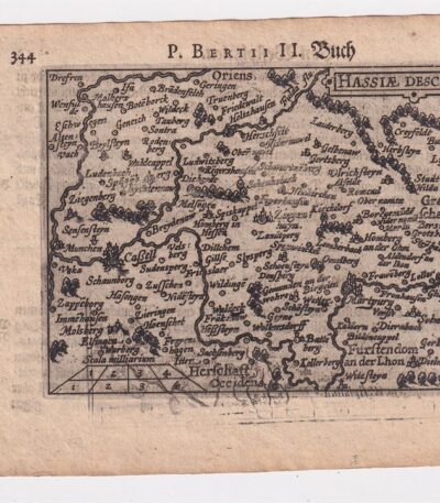
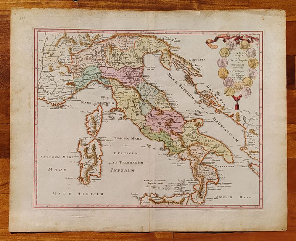
Petrus Bertius, Hesse,1612
40,00 €Petrus Bertius, Hesse It is an original map made in 1612 by Petrus Bertius (1565-1629), a well-known Dutch geographer.
This map is taken from the volume Petri Bertii Geographischer eyn oder zusammengezogener Tabeln Funff unterschiedliche Bucher.
- Paper size: mm. 125×83
- Sheet size: cm. 12×17
- Support: Laid paper
- Condition: Excellent condition

Petrus Bertius, Westfalia,1612
40,00 €Petrus Bertius, Westfalia è una mappa originale acquarellata realizzata nel 1612 da Petrus Bertius, un geografo di origine olandese.
This map is taken from the volume Petri Bertii Geographischer eyn oder zusammengezogener Tabeln Funff unterschiedliche Bucher.
- Sheet size: cm. 12×17 approx.
- Map dimensions: mm. 125×83
- Support: Laid paper
- Condition: Excellent condition

Philippus Cluverius (1580-1622), Germania, 1686
80,00 €Philippus Cluverius è un’incisione in rame acquarellata realizzata nel 1686, proveniente dall’opera Introductionis in universam geographiam, tam veterem quam novam, libri VI, published in Amsterdam.
Questa incisione rappresenta un’importante testimonianza della geografia del XVII secolo e misura mm. 134×140.
- Sheet size: Small
- Engraving size: mm. 134×140
- Support: Laid paper
- Condition: Excellent

Philippus Cluverius (1580-1622), Mappa della Germania 1686
60,00 €Philippus Cluverius (1580-1622) presents a Mappa della Germania Inferiore, built in 1686.
This copper engraving is watercolour and comes from the work Introductionis in universam geographiam, tam veterem quam novam, libri VI, published in Amsterdam in 1686.
- Sheet size: mm. 134×140
- Technique: Burin
- Support: Laid paper
- Condition: Excellent

Philippus Cluverius (1580-1622), Mappa della Germania, 1686
60,00 €Philippus Cluverius – Mappa della Germania It is a watercolour copper engraving made in 1686.
This map is taken from the work Introductionis in universam geographiam, tam veterem quam novam, libri VI, published in Amsterdam.
- Sheet size: mm. 134×140
- Support: Laid paper
- Condition: Excellent condition

Philippus Cluverius (1580-1622), Mappa della Germania, 1686
60,00 €Philippus Cluverius (1580-1622) presents a Map of Germany realizzata nel 1686.
Questa incisione in rame è stata acquarellata e proviene dall’opera Introductionis in universam geographiam, tam veterem quam novam, libri VI, published in Amsterdam.
- Sheet size: mm. 134×140
- Technique: Burin
- Support: Laid paper
- Condition: Excellent
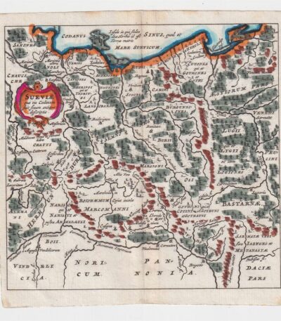
Philippus Cluverius (1580-1622), Mappa della Suevia, 1686
60,00 €Philippus Cluverius (1580-1622) presenta la sua Mappa della Suevia, un’incisione in rame acquarellata realizzata nel 1686.
Questa mappa, che rappresenta la regione della Suevia in Germania, è tratta dall’opera Introductionis in universam geographiam, tam veterem quam novam, libri VI, published in Amsterdam.
- Sheet size: mm. 134×140
- Technique: Burin
- Support: Laid paper
- Condition: Excellent
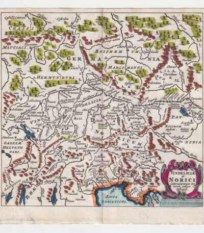
Philippus Cluverius (1580-1622), Mappa della Vindelicia, 1686
60,00 €La Mappa della Vindelicia It is an engraving made by Philippus Cluverius (1580-1622) in 1686.
Questa mappa rappresenta la regione della Vindelicia, situata in Germania, ed è parte dell’opera Introductionis in universam geographiam, tam veterem quam novam, libri VI, published in Amsterdam.
- Sheet size: mm. 134×140
- Technique: Burin
- Support: Laid paper
- Condition: Excellent condition

Prussia, Otto Petri, 1853
50,00 €Mappa della Prussia è un’incisione colorata a mano realizzata da Otto Petri nel 1853.
This map, part of the School Atlas Alle Deelen Der Aarde, pubblicato da J. Van Den Bosch a Rotterdam, offre una rappresentazione dettagliata della Prussia dell’epoca.
- Sheet size: cm. 26×34 approx.
- Engraving size: cm. 22×27 approx.
- Support: Medium thickness paper
- Condition: Excellent condition
- Characteristics: White back, editorial fold

Salzburg, St. Munster, 1614
Salzburg, St. Munster, 1614 è una splendida veduta della città di Salisburgo, estratta dalla celebre opera Cosmography Universalis by Sebastian Munster.
Questa xilografia, realizzata su carta vergellata acquarellata, offre un affascinante sguardo sulla città nel 1614. Sul retro, sono presenti altre immagini che arricchiscono ulteriormente l’opera.
- Sheet size: cm. 36×22 approx.
- Image size: cm. 12.5×15 approx.
- Support: Watercolored laid paper
- Condition: Excellent
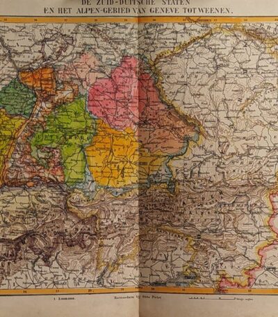
States of Germany, Otto Petri, 1853
50,00 €Stati della Germania è una mappa incisa a mano da Otto Petri nel 1853, che rappresenta gli stati della Germania meridionale e l’area delle Alpi, da Ginevra a Vienna.
Questa incisione colorata è parte del School Atlas Alle Deelen Der Aarde, published by J. Van Den Bosch in Rotterdam.
- Sheet size: cm. 26×34 approx.
- Engraving size: cm. 22×27 approx.
- Support: Medium thickness paper
- Condition: Excellent state of preservation
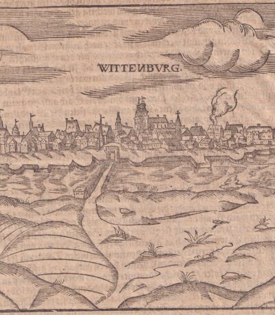
Wittenburg, St.Munster, 1614
Wittenburg, S.Munster è una veduta di Wittenberg, rappresentante un’importante località legata a Martin Lutero in Germania.
This engraving is taken from the famous work Cosmography Universalis di Sebastian Munster, pubblicata a Basilea nel 1614. Sul retro si trova un’immagine di Martin Lutero, figura centrale della Riforma protestante.
- Sheet size: cm. 36×22 approx.
- Image size: cm. 12×15 approx.
- Support: Watercolored laid paper
- Condition: Excellent state of preservation
