
Small

Max Kislinger (Austria) exlibris
10,00 €Exlibris by Max Kislinger è un’incisione realizzata in Austria, che riflette l’arte della xilografia.
Questo exlibris, con dimensioni contenute, è un perfetto esempio di come l’arte possa personalizzare i libri e renderli unici.
- Sheet size: cm. 11×15 approx.
- Technique: Woodcut
- Support: Cardboard
- Condition: Excellent

Max Kislinger (Austria) exlibris
10,00 €Exlibris by Max Kislinger è un’opera incisoria realizzata dall’artista austriaco Max Kislinger.
Questo exlibris, caratterizzato da un design unico, è un esempio di xilografia, una tecnica che permette di ottenere immagini di grande impatto visivo.
- Sheet size: cm. 11×15 approx.
- Support: Cardboard
- Condition: Excellent

Max Kislinger (Austria) exlibris
10,00 €Exlibris by Max Kislinger è un’opera realizzata nel 1932 dall’artista austriaco Max Kislinger.
Questa xilografia rappresenta un esempio distintivo di arte grafica, utilizzata tradizionalmente per contrassegnare i libri di proprietà.
- Sheet size: cm. 11×15 approx.
- Technique: Woodcut
- Support: Cardboard
- Condition: Excellent

Max Kislinger (Austria) exlibris
10,00 €Exlibris by Max Kislinger è un’opera realizzata nel 1971 dall’artista austriaco Max Kislinger.
Questa xilografia, caratterizzata da un design unico e dettagliato, rappresenta un esempio pregiato di arte grafica.
- Sheet size: cm. 11×15 approx.
- Support: Cardboard
- Condition: Excellent

Max Kislinger (Austria) exlibris
10,00 €Exlibris by Max Kislinger è un’opera realizzata nel 1967 dall’artista austriaco Max Kislinger.
Questo exlibris, caratterizzato da un design unico, è stato creato utilizzando la tecnica della woodcut.
- Sheet size: cm. 11×15
- Support: Cardboard
- Condition: Excellent

Max Kislinger (Austria) exlibris
10,00 €Exlibris by Max Kislinger è un’opera realizzata nel 1973 dall’artista austriaco Max Kislinger.
Questo exlibris è un esempio di xilografia, una tecnica incisoria che permette di ottenere immagini di grande impatto visivo.
- Sheet size: cm. 11×15 approx.
- Condition: Excellent
- Support: Cardboard

Max Kislinger (Austria) exlibris
10,00 €Exlibris by Max Kislinger It is a work created in 1979 dall’artista austriaco Max Kislinger.
Questo exlibris, che rappresenta un esempio di arte grafica, è stato creato utilizzando la tecnica della woodcut, un metodo tradizionale di incisione su legno.
- Sheet size: cm. 11×15 approx.
- Condition: Excellent
- Support: Cardboard

Max Kislinger (Austria) exlibris
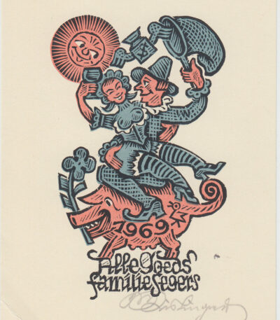
10,00 €Exlibris by Max Kislinger è un’opera realizzata nel 1969 dall’artista austriaco Max Kislinger.
Questo exlibris, caratterizzato da una raffinata woodcut, rappresenta un esempio significativo dell’arte grafica del XX secolo.
- Sheet size: cm. 11×15
- Condition: Excellent
- Support: Cardboard
Max Kislinger (Austria) exlibris
10,00 €Exlibris by Max Kislinger è un’opera realizzata nel 1969 dall’artista austriaco Max Kislinger.
Questo exlibris, caratterizzato da un design unico, è un esempio di xilografia, una tecnica incisoria che conferisce profondità e dettagli all’immagine.
- Sheet size: cm. 11×15
- Support: Cardboard
- Condition: Excellent

Max Kislinger (Austria) exlibris
10,00 €Exlibris by Max Kislinger è un’opera realizzata in Austria, caratterizzata da un design distintivo e originale.
Questo exlibris è un esempio di xilografia, una tecnica incisoria che conferisce profondità e dettaglio all’immagine.
- Sheet size: cm. 11×15 approx.
- Support: Cardboard
- Condition: Excellent

Max Kislinger (Austria) exlibris
10,00 €Exlibris by Max Kislinger è un’opera realizzata nel 1969 dall’artista austriaco Max Kislinger.
Questo exlibris, caratterizzato da un design distintivo, è un esempio di xilografia che riflette l’abilità dell’artista nel creare opere incisorie di grande impatto visivo.
- Sheet size: cm. 11×15 approx.
- Support: Cardboard
- Condition: Excellent

Max Kislinger (Austria) exlibris
10,00 €Exlibris by Max Kislinger è un’incisione realizzata dall’artista austriaco Max Kislinger.
Questo exlibris, che funge da marchio di proprietà per i libri, è un esempio pregevole di woodcut, una tecnica incisoria che permette di ottenere immagini dettagliate e affascinanti.
- Sheet size: cm. 11×15
- Support: Cardboard
- Condition: Excellent

Max Kislinger (Austria) exlibris
10,00 €Exlibris by Max Kislinger It is a work created in 1960, rappresentativa dello stile dell’artista austriaco.
Questo exlibris, realizzato in woodcut, è un esempio di come l’arte grafica possa unire funzionalità e bellezza.
- Sheet size: cm. 11×15
- Condition: Excellent
- Support: Cardboard

Max Kislinger (Austria) exlibris
10,00 €Exlibris by Max Kislinger è un’opera realizzata nel 1975 dall’artista austriaco Max Kislinger.
Questo exlibris, una piccola incisione destinata a identificare il proprietario di un libro, è un esempio di raffinata xilografia a colori.
- Sheet size: cm. 11×15 approx.
- Technique: Woodcut
- Support: Cardboard
- Condition: Excellent

Max Kislinger (Austria) exlibris
10,00 €Exlibris by Max Kislinger It is a work created by the Austrian artist Max Kislinger.
This exlibris, which represents a distinctive sign of belonging to a book collection, was created using the technique of woodcut.
- Sheet size: cm. 11×15 approx.
- Support: Cardboard
- Condition: Excellent

Max Kislinger (Austria) exlibris
10,00 €Exlibris by Max Kislinger è un’opera realizzata nel 1969 dall’artista austriaco Max Kislinger.
Questo exlibris, una forma d’arte dedicata all’identificazione dei libri, è realizzato in woodcut e presenta un design unico e affascinante.
- Sheet size: cm. 11×15
- Support: Cardboard
- Condition: Excellent

Max Kislinger (Austria) exlibris
10,00 €Exlibris by Max Kislinger è un’opera realizzata nel 1979 dall’artista austriaco Max Kislinger.
Questa xilografia colorata rappresenta un esempio distintivo di arte grafica, perfetta per collezionisti e amanti dell’arte.
- Sheet size: cm. 11×15 approx.
- Support: Cardboard
- Condition: Excellent

Max Kislinger (Austria) exlibris
10,00 €Exlibris by Max Kislinger è un’opera realizzata nel 1963 dall’artista austriaco Max Kislinger.
Questo exlibris, un’etichetta utilizzata per identificare il proprietario di un libro, è realizzato con la tecnica della woodcut, che conferisce un carattere unico e distintivo all’opera.
- Sheet size: cm. 11×15 approx.
- Support: Cardboard
- Condition: Excellent

Mazzarino Giulio, 1846
15,00 €Mazzarino Giulio è un’incisione su rame realizzata nel 1846, tratta dall’Picturesque Omnibus.
Questa stampa misura circa cm. 14×10 e presenta testo sia intorno che al verso.
- Sheet size: Small
- Engraving size: cm. 14×10 approx.
- Support: Paper
- Condition: Excellent
Giulio Raimondo Mazzarino, noto anche come Jules Raymond Mazarin, è stato un importante cardinale e politico italiano, attivo in Francia come Principale Ministro sotto Luigi XIV.
The entire page of the book containing the print will be sent.

Mazzorbo, Venice, 1832
25,00 €Mazzorbo, Venice It is an engraving made in 1832, printed by C. Stanfield and published in Picturesque Annual based on a drawing by Clarkson Stanfield.
This work represents a fascinating glimpse of the Venetian lagoon, created using the etching and burin technique.
- Sheet size: cm. 12×19 approx.
- Engraving size: cm. 10×13 approx.
- Support: Paper
- Condition: Excellent condition
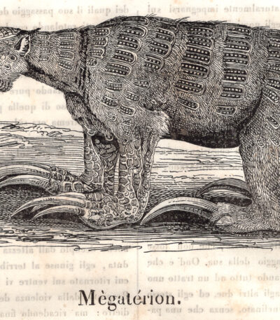
Megaterion, animali leggendari, 1843
20,00 €Xilografia realizzata nel 1843, estratta dal volume Pictorial Cosmorama, Anno nono, ed è caratterizzata da margini quasi assenti.
- Sheet size: cm. 28×20 approx.
- Dimensione della immagine: cm. 8×15 approx.
- Technique: Woodcut
- Condition: buona, scritto al verso del foglio, in parte visibile al recto.
- Support: Paper
La stampa è stata estratta dal libro e presenta scritte al verso in parte visibili, viene spedita la pagina intera che contiene la stampa .
Pictorial Cosmorama fu una rivista illustrata fondata a Milano da Giovanni Francesco Zini, avvocato. Molti degli esponenti della società artistico-letteraria milanese (Carlo Tenca, Alessandro Lampugnani nonché un esordiente Antonio Ghislanzoni) si accostarono al giornalismo facendo le prime esperienze sul «Cosmorama Pittorico», che ebbe il merito di essere la prima rivista in cui le illustrazioni ricoprirono un ruolo importante (novità questa che fu rimproverata da Carlo Cattaneo, che pure fu un collaboratore assiduo). Dopo il 1848 la rivista entrò in crisi e fu chiusa.
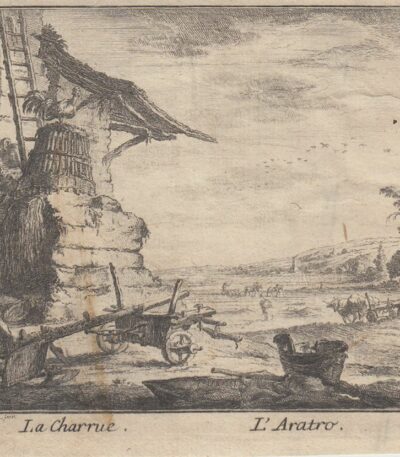
Meil Johann Wilhelm (1733-1805)
20,00 €L’Aratro It is an engraving made by Johann Wilhelm Meil (1733-1805) tramite la tecnica dell’Etching.
Questa opera, che rappresenta un tema agricolo, è stata creata con grande maestria e si distingue per i suoi dettagli accurati.
- Engraving size: mm. 127×100
- Support: Carta vergellata senza filigrana, retro bianco
- Condition: Good condition

Meina, View of Angera, 1890
20,00 €Meina, View of Angera It is a woodcut made in 1890 by E. Bondier, a French cartoonist and illustrator known for his views of Italy.
This print, from a late 19th-century French book, features a lively, animated scene, capturing the essence of the Italian landscape.
- Sheet size: cm. 12×13 approx.
- Technique: Woodcut
- Condition: Excellent
- Support: Paper
The print has been cut from the book and has writing on the back. The full page containing the print will be sent.
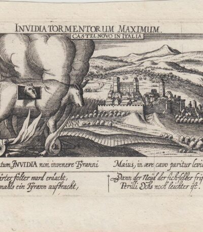
Meisner, Castelnovo di Porto, 1678
60,00 €Meisner, Castelnovo di Porto, 1678 è una veduta tratta dall’edizione del 1678 della celebre Sciagraphia Cosmica.
Questa incisione in rame presenta margini e si trova in perfetto stato di conservazione.
- Sheet size: cm. 13×19 approx.
- Engraving size: cm. 10×15 approx.
- Support: Laid paper without watermark
- Condition: Excellent state of preservation
