
Shop

1575 Universal Cosmography, Coat of Arms of Lyon
20,00 €1575 Universal Cosmography, Coat of Arms of Lyon it is an engraving in woodcut taken from the famous work Universal Cosmography by Sebastian Munster, published in 1575 in Paris.
This page, which includes the coat of arms of Lyon, is a significant example of 16th-century cartography and geographical representation.
- Sheet size: cm. 21×34
- Image size: cm. 3,5×4
- Support: Paper
- Condition: Excellent

1575 Universal Cosmography, Coat of Arms of Monaco
30,00 €1575 Universal Cosmography, Coat of Arms of Monaco It is a watercolour woodcut engraving taken from the Universal Cosmography by Sebastian Münster, published in 1575 in Paris by Michel Sonnius.
This work represents one of the most influential texts of the 16th century, known for its detailed description of the world.
- Sheet size: cm. 21×34 approx.
- Engraving size: cm. 7×7 approx.
- Support: Paper
- Condition: Excellent state of preservation
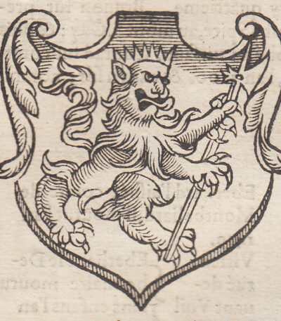
1575 Universal Cosmography, Coat of Arms of St. Gall
20,00 €Stemma di San Gallo è un’incisione xilografica realizzata nel 1575, parte della Universal Cosmography by Sebastian Münster.
Questa opera è un’importante testimonianza della prima descrizione del mondo in lingua tedesca, pubblicata in numerose edizioni e traduzioni.
- Sheet size: cm. 21×34 approx.
- Engraving size: cm. 7×7 approx.
- Support: Paper
- Condition: Excellent state of preservation
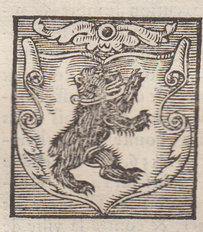
1575 Universal Cosmography, Coat of Arms of Zimbern and Teck
20,00 €1575 Universal Cosmography, Coat of Arms of Zimbern and Teck it is a woodcut taken from the famous work Universal Cosmography by Sebastian Münster, published in 1575 in Paris by Michel Sonnius.
Questo stemma rappresenta i Baroni di Zimbern e i Duchi di Teck, ed è un esempio significativo della cartografia del XVI secolo.
- Sheet size: cm. 21×34 approx.
- Image size: cm. 7×7 approx.
- Support: Paper
- Condition: Excellent

1575 Universal Cosmography, Basel Earthquake in 1356
20,00 €1575 Universal Cosmography, Basel Earthquake in 1356 it is an engraving in woodcut taken from the famous work Universal Cosmography by Sebastian Münster, published in 1575 in Paris by Michel Sonnius.
This piece represents an important historical testimony, since the Cosmography Universalis It was the first description of the world in the German language and was a huge success in the 16th century, with numerous editions in different languages.
- Sheet size: cm. 21×34 approx.
- Engraving size: cm. 12×7 approx.
- Support: Paper
- Condition: Excellent state of preservation
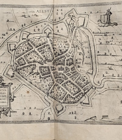
1578, Georg Braun, Frans Hogenberg, map of Alost AAlst Belgium from Civitates Terrarum
140,00 €Alost (Aalst), Belgio, incisione di Georg Braun e Frans Hogenberg, pubblicata nel 1578 come parte del celebre atlante Cities of the Earth's Orb.
Questa splendida mappa rappresenta la città belga di Alost (Aalst) in epoca rinascimentale, evidenziando con grande cura le strutture urbane, i dettagli topografici e i principali edifici storici. L’opera, accompagnata dal contributo editoriale di R. A. Skelton, è un importante esempio dell’arte cartografica del XVI secolo.
- Era: Renaissance (16th century)
- Technique: Etching
- Dimensions: Grandi (cm 42 x 54)
- Support: Laid paper
- Condition: Excellent
Questo pezzo storico, estratto dal volume Cities of the Earth's Orb, costituisce un’aggiunta eccezionale per collezionisti di mappe antiche o per chiunque desideri arricchire la propria collezione con un’opera d’arte dal valore storico e artistico inestimabile.
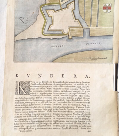
1582, Georg Braun, Frans Hogenberg, map of Kundera Kinderdijk, from Civitates Orbis
80,00 €Kuynder-Schans, incisione di George Brown And Frans Hogenberg, 1582
Questa affascinante stampa, realizzata come acquaforte, è tratta dal celebre atlante Cities of the Earth's Orb, una delle opere cartografiche più importanti del XVI secolo. La mappa raffigura l’insediamento di Kuynder-Schans (oggi Kinderdijk?) nei Paesi Bassi, e combina dettagli artistici e topografici in uno stile tipico dell’epoca.
- Era: XVI secolo (1582)
- Technique: Etching
- Dimensions: Grandi (cm 42 x 27)
- Support: Laid paper
- Condition: Excellent condition
Quest’opera rappresenta un’importante testimonianza della storia cartografica e artistica del Rinascimento, perfetta per collezionisti o appassionati di stampe antiche.
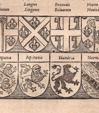
1614 Cosmografia Universale, I Paria di Francia, stemmi delle regioni francesi del XIV secolo
30,00 €This engraving is taken from the famous work Cosmography Universalis by Sebastian Munster, published in Basel in 1614.
- Sheet size: cm. 36×22 circa
- Dimensioni dell’immagine: cm. 6×15 circa
- Support: Laid paper
- Condition: Excellent state of preservation
Gli stemmi rappresentano le seguenti regioni:
- Reims
- Beauvais
- Langres
- Laon
- Chalons
- Noyons
- Burgundy
- Normandy
- Aquitaine
- Flanders
- Champagne
- Toulouse
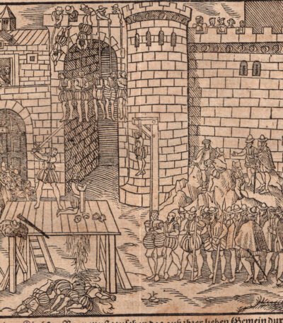
1614 Cosmografia Universale, Massacro dei Cristiani in Francia, decapitazioni
30,00 €This engraving is taken from the famous work Cosmography Universalis by Sebastian Munster, published in Basel in 1614.
- Sheet size: cm. 36×22 circa
- Dimensioni dell’immagine: cm. 10×15 circa
- Support: Laid paper
- Condition: Excellent state of preservation
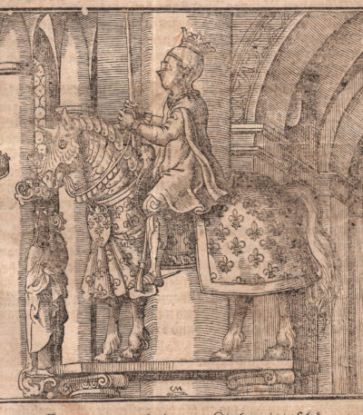
1614, Filippo VI di Valois re di Francia, dalla Cosmografia di Munster
40,00 €Sebastian Münster – Cosmographia Universalis, Basilea 1614
Suggestiva woodcut raffigurante Filippo di Valois, tratta da una pagina dell’edizione tedesca della celebre Cosmography Of Sebastian Münster, pubblicata a Basilea nel 1614.
🖋 Scheda descrittiva:
-
Titolo: Filippo VI re di Francia
-
Autore dell’opera: Sebastian Münster (1488–1552)
-
Opera: Cosmographey. Oder beschreibung Aller Länder…
-
Place of publication: Basilea
-
Anno dell’edizione: 1614 (edizione postuma)
-
Technique: Woodcut on laid paper
-
Coloration: Acquerellata a mano
-
Back: Testo stampato in tedesco
-
Sheet size: cm 36 x 22
-
Dimensioni dell’immagine (battuta): cm 15x 16 circa
-
Conditions: Excellent
🎨 Descrizione iconografica:
Filippo IV, noto anche come Filippo il Bello, è stato re di Francia dal 1285 al 1314. Durante il suo regno, ha preso parte a importanti eventi storici e ha intrapreso azioni significative per consolidare il potere della monarchia francese.
Una delle principali azioni di Filippo il Bello è stata l’appoggio agli Angioini nella guerra del Vespro in Sicilia. Questo conflitto scoppiò nel 1282 tra gli Angioini, che erano sostenuti dalla Francia, e gli Aragonesi, che avevano il sostegno della Corona d’Aragona. Filippo IV inviò truppe francesi per aiutare gli Angioini e tentò di ottenere il controllo dell’isola. Sebbene il conflitto non si risolvesse a suo favore, questa azione dimostrò la volontà di Filippo di intervenire in questioni estere e di sostenere gli interessi del suo regno.
📚 Contesto storico-editoriale:
There Cosmography Universalis, stampata per la prima volta nel 1544, è una delle opere geografiche e enciclopediche più importanti del XVI secolo. Questa pagina è tratta da un’edizione stampata a Basilea nel 1614, postuma ma ancora basata sui testi e sulle xilografie originali di Münster, spesso arricchite con colorazioni coeve.
📌 Comments:
-
Esemplare ben conservato, su bella carta vergellata.
-
There presenza del testo al verso conferma la sua origine da un volume rilegato.
-
Opera di grande fascino e valore iconografico e culturale, ideale per collezionisti di stampe antiche, cartografia e illustrazione rinascimentale.
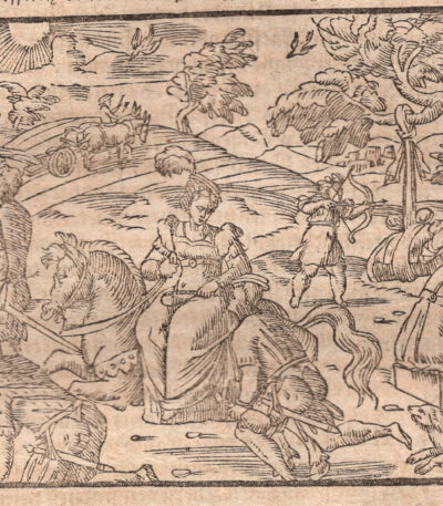
1614, Usi e costumi della Gallia, dalla Cosmografia di Munster
40,00 €Sebastian Münster – Cosmographia Universalis, Basilea 1614
Suggestiva woodcut tratta da una pagina dell’edizione tedesca della celebre Cosmography Of Sebastian Münster, pubblicata a Basilea nel 1614.
🖋 Scheda descrittiva:
-
Autore dell’opera: Sebastian Münster (1488–1552)
-
Opera: Cosmographey. Oder beschreibung Aller Länder…
-
Place of publication: Basilea
-
Anno dell’edizione: 1614 (edizione postuma)
-
Technique: Woodcut on laid paper
-
Back: Testo stampato in tedesco
-
Sheet size: cm 36 x 22
-
Dimensioni dell’immagine (battuta): cm 8 x 10 circa
-
Conditions: Excellent
📚 Contesto storico-editoriale:
There Cosmography Universalis, stampata per la prima volta nel 1544, è una delle opere geografiche e enciclopediche più importanti del XVI secolo. Questa pagina è tratta da un’edizione stampata a Basilea nel 1614, postuma ma ancora basata sui testi e sulle xilografie originali di Münster.
📌 Comments:
-
Esemplare ben conservato, su bella carta vergellata.
-
There presenza del testo al verso conferma la sua origine da un volume rilegato.
-
Opera di grande fascino e valore iconografico e culturale, ideale per collezionisti di stampe antiche, storia della Bibbia, cartografia e illustrazione rinascimentale.
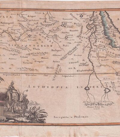
1701, Africa from the Cellarium
60,00 €Africa from Cellario It is a copper engraving made in 1701, taken from the work Notitia Orbis Antiqui sive Geographia Plenior by Christophorus Cellarius.
This map represents a detailed view of Africa and measures cm. 20×30 approximately, on a sheet of cm. 24×33.
- Sheet size: cm. 24×33 approx.
- Engraving size: cm. 20×30 approx.
- Support: Paper
- Condition: Good, with some stains on the edges and editorial creases
1701, Africa, from Cellario Cellarius
60,00 €Africa It is a copper engraving made in 1701, taken from the volume Notitia Orbis Antiqui sive Geographia Plenior by Christophorus Cellarius.
This work offers a detailed representation of the African continent at the time, highlighting the geographical knowledge of the time.
- Sheet size: cm. 24×38 approx.
- Engraving size: cm. 20×35 approx.
- Support: Paper
- Condition: Good, with some stains on the edges and editorial creases
1701, Africa, Map, copper engraving from Cellario
60,00 €Africa, Mappa è un’incisione su rame realizzata da Christophorus Cellarius nel 1701, tratta dal suo celebre lavoro Notitia Orbis Antiqui sive Geographia Plenior.
Questa mappa offre una rappresentazione dettagliata del continente africano dell’epoca, con colori vivaci applicati a mano che ne esaltano la bellezza.
- Sheet size: cm. 24×33 approx.
- Engraving size: cm. 20×30 approx.
- Support: Paper
- Condition: Good, with some stains on the edges
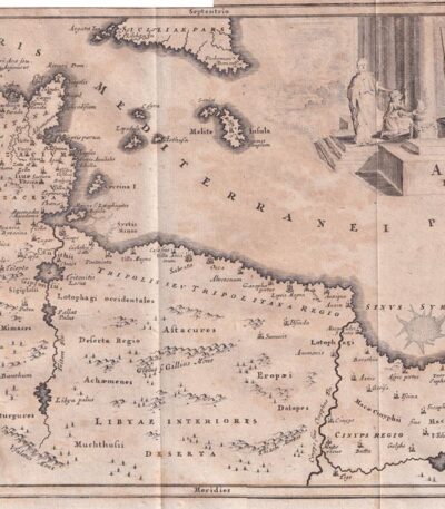
1701, Arabia from the Cellarius
60,00 €Arabia dal Cellario è un’incisione su rame realizzata nel 1701, che rappresenta una mappa dettagliata delle regioni di Arabia, Babilonia e Caldea.
This work is taken from Notitia Orbis Antiqui sive Geographia Plenior by Christophorus Cellarius.
- Sheet size: cm. 24×33 approx.
- Engraving size: cm. 20×30 approx.
- Support: Paper
- Condition: Good, with some stains on the edges
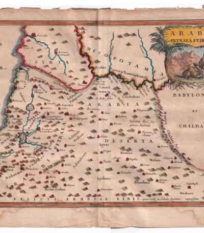
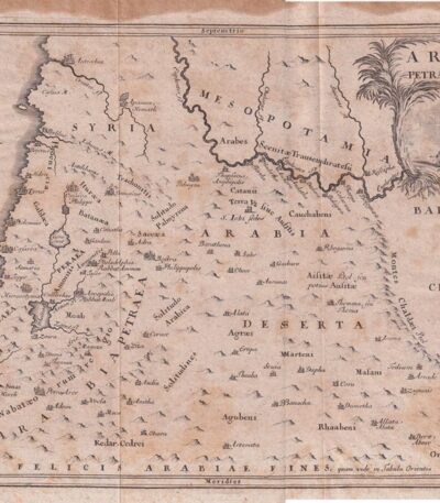
1701, Arabia Map from Cellario
60,00 €1701, Arabia Map from Cellario è un’incisione su rame che rappresenta la regione dell’Arabia, Siria e Mesopotamia.
This map is taken from Notitia Orbis Antiqui sive Geographia Plenior by Christophorus Cellarius, published in 1701.
- Sheet size: cm. 24×33 approx.
- Engraving size: cm. 20×30 approx.
- Support: Paper
- Condition: Good, with some stains on the edges
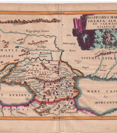
1701, Bosphorus, Albania, Map, copper engraving
60,00 €Mappa del Bosforo, Albania It is a copper engraving made in 1701, taken from the volume Notitia Orbis Antiqui sive Geographia Plenior by Christophorus Cellarius.
Questa mappa, colorata a mano, offre una rappresentazione dettagliata della regione del Bosforo, evidenziando le caratteristiche geografiche dell’epoca.
- Sheet size: cm. 24×33 approx.
- Engraving size: cm. 20×30 approx.
- Support: Paper
- Condition: Good, with some stains on the edges
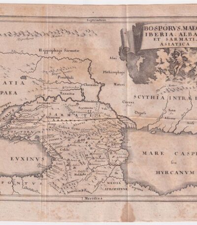
1701, Bosphorus, from the Cellarium
60,00 €1701, Bosforo It is a copper engraving made by Christophorus Cellarius, taken from the work Notitia Orbis Antiqui sive Geographia Plenior published in 1701.
Questa mappa rappresenta le regioni di Iberia, Albania e Sarmazia, offrendo una visione storica e geografica di queste aree.
- Sheet size: cm. 24×33 approx.
- Engraving size: cm. 20×30 approx.
- Support: Paper
- Condition: Buone, con qualche macchia ai margini e alcune pieghe editoriali
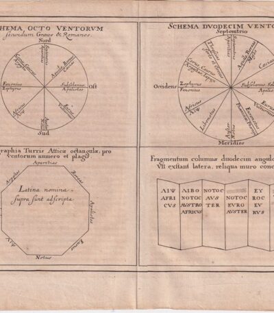
1701, Wind Chart, from the Cellarium
60,00 €1701, Wind Chart It is a copper-engraved map, taken from Notitia Orbis Antiqui sive Geographia Plenior by Christophorus Cellarius, published in 1701.
This engraving offers a detailed representation of the winds, a theme of great importance in ancient geography.
- Sheet size: cm. 24×33 approx.
- Engraving size: cm. 20×30 approx.
- Support: Paper
- Condition: Good, with some stains on the edges and editorial creases

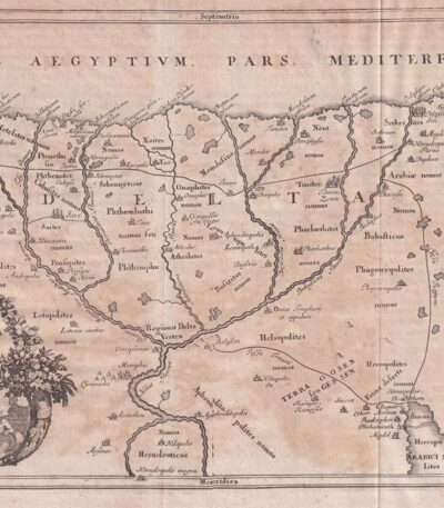
1701, Egypt and Cyrenaica, Map, from the Cellario
70,00 €1701, Egypt and Cyrenaica è una mappa incisa su rame, tratta dal volume Notitia Orbis Antiqui sive Geographia Plenior by Christophorus Cellarius, published in 1701.
Questa mappa, colorata a mano, offre una rappresentazione dettagliata delle regioni storiche dell’Egitto e della Cirenaica.
- Sheet size: cm. 24×33 approx.
- Engraving size: cm. 20×30 approx.
- Support: Paper
- Condition: Good, with some stains on the edges
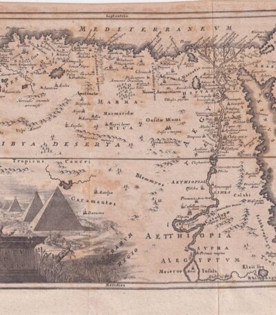
1701, Egypt and the Nile, Cellarius
60,00 €1701, Egypt and the Nile It is a copper engraving made by Christophorus Cellarius, taken from the work Notitia Orbis Antiqui sive Geographia Plenior published in 1701.
This engraving offers a detailed representation of Egypt and the Nile, highlighting the geographical and cultural importance of the region.
- Sheet size: cm. 24×38 approx.
- Engraving size: cm. 20×35 approx.
- Support: Paper
- Condition: Good, with some stains on the edges and editorial creases
1701, Egypt copper engraving, from the Cellario
60,00 €1701, Egypt and Cyrenaica it is a copper engraving taken from the volume Notitia Orbis Antiqui sive Geographia Plenior by Christophorus Cellarius, published in 1701.
This map offers a detailed representation of the historical regions of Egypt and Cyrenaica, making it an important cartographic testimony of the time.
- Sheet size: cm. 24×33 approx.
- Engraving size: cm. 20×30 approx.
- Support: Paper
- Condition: Good, with some stains on the edges and editorial creases

1701, France Map, copper engraving from Cellario
90,00 €Mappa della Gallia e Aquitania è un’incisione su rame realizzata da Christophorus Cellarius nel 1701.
This work is taken from Notitia Orbis Antiqui sive Geographia Plenior, un’opera che offre una visione dettagliata della geografia antica.
- Sheet size: cm. 24×33 approx.
- Engraving size: cm. 20×30 approx.
- Support: Paper
- Condition: Good condition

1701, Mauritania by Cellario Cellarius
60,00 €1701, Mauritania è un’incisione su rame realizzata da Christophorus Cellarius nel 1701, tratta dal volume Notitia Orbis Antiqui sive Geographia Plenior.
Questa opera rappresenta una mappa storica delle regioni di Mauritania e Numidia.
- Sheet size: cm. 24×38 approx.
- Engraving size: cm. 20×35 approx.
- Support: Paper
- Condition: Good, with some stains on the edges and editorial creases
