
Shop

Pencil on brown paper, Face of an old woman, 19th century.
35,00 €Volto di Vecchia è un’opera realizzata in matita e acquarello con rialzi a biacca, risalente al 19th century.
Questa rappresentazione di una donna anziana con copricapo è eseguita su carta leggera di colore marrone, mostrando la maestria di un artista esperto.
- Sheet size: cm. 24×20 approx.
- Technique: Burin
- Condition: Excellent
- Support: Paper

Matita su carta, Papa, XIX sec.
35,00 €Matita su carta, Papa è un raffinato disegno a matita risalente al 19th century.
Questo lavoro anonimo rappresenta un Papa o un Vescovo, realizzato con grande maestria da un artista esperto.
- Sheet size: cm. 20×15 approx.
- Technique: Burin
- Support: Carta leggera con filigrana
- Condition: Excellent

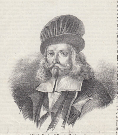
Pencil, Gentleman, 19th century
40,00 €Pencil, Gentleman It is a refined pencil drawing depicting a half-length portrait of a gentleman, made in 19th century.
This anonymous work is notable for its splendid execution, typical of an expert artist.
- Sheet size: cm. 23×18 approx.
- Drawing dimensions: cm. 11×10 approx.
- Support: Paper
- Condition: Excellent state of preservation
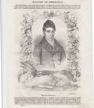
Matteo Di Dombasle, 1845
15,00 €Matteo Di Dombasle It is a lithograph made in 1845, coming from the volume Picturesque Polyorama of Naples.
This engraving represents a half-length del celebre agronomo francese Matteo Dombasle.
- Sheet size: cm. 29×20 approx.
- Engraving size: cm. 20×15 approx.
- Support: Paper
- Condition: Excellent
Viene spedita l’intera pagina del libro, che include scritte sul retro.

Matthaus Greuter, Roma, Colonna Traiana e Colonna Antonina, 1618
50,00 €Incisione realizzata nel 1618 da Matthaus Greuter (1564-1638), utilizzando la tecnica dell’acquaforte su rame.
Questa opera è stampata su carta spessa vergellata con retro bianco.
- Sheet size: cm. 20×21 circa
- Dimensioni dell’incisione: cm. 19×20 circa
- Support: Laid paper
- Condition: Pieghe editoriali, qualche macchia, ma nel complesso buone condizioni.
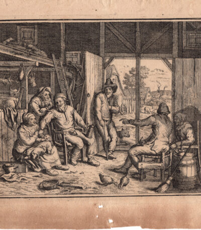
Matthias Scheits (Amburgo, 1630 – 1700), Compagnia di uomini e donne in un fienile.
60,00 €Compagnia di uomini e donne in un fienile.
Data: 1676. Matthias Scheits , tipografo (1625–1700)
Su carta vergellata con filigrana non riconosciuta.
Misura cm. 16×21 alla battuta del rame su foglio cm. 19×24. Foglio un po scurito con qualche lieve macchia.
Matthias Scheits (Amburgo, 1630 – Amburgo, 1700) è stato un pittore barocco tedesco.
Secondo Houbraken era ad Amburgo mentre Johannes Voorhout era lì e, sebbene si fosse inizialmente formato ad Haarlem sotto Philips Wouwerman, in seguito dipinse scene di fattorie e villaggi alla maniera di David Teniers. Voorhout lo incontrò mentre lavorava a schizzi storici che furono poi pubblicati con il suo nome come stampe dell’Antico e del Nuovo Testamento.
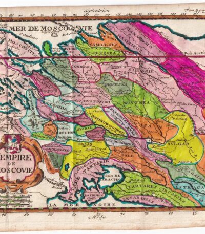
Matthieu Ogier, Map of the Russian States, Moscow, 1700
40,00 €Map of Russian states It is an engraving made by Matthieu Ogier in 1700.
This map, titled The Empire of Moscow, is colored in watercolour and represents a precious cartographic testimony of the time.
- Sheet size: cm. 16×23 approx.
- Map dimensions: cm. 14×18 approx.
- Technique: Burin
- Condition: Excellent
- Support: Paper
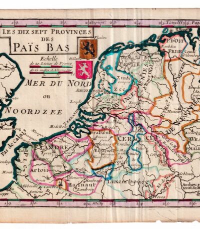
Matthieu Ogier, Map of the Netherlands, Holland, 1700
50,00 €Matthieu Ogier, Map of the Netherlands It is an engraving made in 1700, representing the seventeen provinces of the Netherlands.
This map was engraved by Matthieu Ogier and hand-colored in watercolor, making it a unique and fascinating piece.
- Sheet size: cm. 16×23 approx.
- Map dimensions: cm. 14×18 approx.
- Support: Paper
- Condition: Excellent
Mattia Preti, 1843
15,00 €Mattia Preti, 1843 è una litografia tratta da Picturesque Polyorama, pubblicata a Napoli nel 1843.
Questa opera misura cm. 10×13 ed è retro stampata; la stampa è stata estratta dal libro e presenta scritte al retro.
- Artist: Mattia Preti, noto anche come il Cavalier Calabrese, è stato un importante pittore italiano, attivo per oltre sessant’anni.
- Era: 19th century
- Dimensions: Small
- Technique: Lithography
- Condition: Excellent
- Support: Paper
Verrà spedita l’intera pagina del libro contenente la stampa.

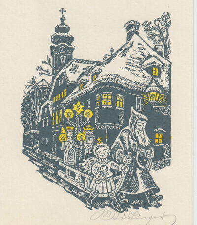
Max Kislinger (Austria) exlibris
10,00 €Exlibris by Max Kislinger è un’opera realizzata nel 1976 dall’artista austriaco Max Kislinger.
Questa xilografia, caratterizzata da un uso sapiente del colore, rappresenta un esempio distintivo di exlibris, un’etichetta utilizzata per identificare la proprietà di un libro.
- Sheet size: cm. 11×15 approx.
- Support: Cardboard
- Condition: Excellent

Max Kislinger (Austria) exlibris
10,00 €Exlibris by Max Kislinger è un’opera realizzata nel 1966 dall’artista austriaco Max Kislinger.
Questo exlibris è un esempio di xilografia, una tecnica incisoria che consente di ottenere dettagli raffinati e un forte contrasto.
- Sheet size: cm. 11×15 approx.
- Support: Cardboard
- Condition: Excellent

Max Kislinger (Austria) exlibris
10,00 €Exlibris by Max Kislinger It is a work created by the Austrian artist Max Kislinger.
Questo exlibris, che rappresenta un esempio di arte grafica, è realizzato in woodcut e si distingue per la sua eleganza e il suo stile distintivo.
- Sheet size: cm. 11×15 approx.
- Support: Cardboard
- Condition: Excellent

Max Kislinger (Austria) exlibris
10,00 €Exlibris by Max Kislinger è un’opera realizzata nel 1941 dall’artista austriaco Max Kislinger.
Questo exlibris, caratterizzato da un design unico, è un esempio pregevole di xilografia.
- Sheet size: cm. 11×15
- Support: Cardboard
- Condition: Excellent
Max Kislinger (Austria) exlibris
10,00 €Exlibris by Max Kislinger è un’opera realizzata nel 1963 dall’artista austriaco Max Kislinger.
Questo exlibris, caratterizzato da un design unico, è un esempio di xilografia, una tecnica incisoria che conferisce profondità e dettaglio all’immagine.
- Sheet size: cm. 11×15 approx.
- Condition: Excellent
- Support: Cardboard

Max Kislinger (Austria) exlibris
10,00 €Exlibris by Max Kislinger è un’opera realizzata nel 1959 dall’artista austriaco Max Kislinger.
Questo exlibris, che rappresenta un esempio di arte grafica, è stato creato utilizzando la tecnica della woodcut, un metodo tradizionale di incisione su legno.
- Sheet size: cm. 11×15
- Condition: Excellent
- Support: Cardboard

Max Kislinger (Austria) exlibris
10,00 €Exlibris by Max Kislinger It is a work made in woodcut nel 1959 dall’artista austriaco Max Kislinger.
Questo exlibris, di dimensioni contenute, è un esempio di arte grafica che riflette l’estetica del periodo.
- Sheet size: cm. 11×15 approx.
- Support: Cartoncino leggero
- Condition: Excellent

Max Kislinger (Austria) exlibris
10,00 €Exlibris by Max Kislinger è un’incisione realizzata in Austria, che riflette l’arte della xilografia.
Questo exlibris, con dimensioni contenute, è un perfetto esempio di come l’arte possa personalizzare i libri e renderli unici.
- Sheet size: cm. 11×15 approx.
- Technique: Woodcut
- Support: Cardboard
- Condition: Excellent

Max Kislinger (Austria) exlibris
10,00 €Exlibris by Max Kislinger è un’opera incisoria realizzata dall’artista austriaco Max Kislinger.
Questo exlibris, caratterizzato da un design unico, è un esempio di xilografia, una tecnica che permette di ottenere immagini di grande impatto visivo.
- Sheet size: cm. 11×15 approx.
- Support: Cardboard
- Condition: Excellent

Max Kislinger (Austria) exlibris
10,00 €Exlibris by Max Kislinger è un’opera realizzata nel 1932 dall’artista austriaco Max Kislinger.
Questa xilografia rappresenta un esempio distintivo di arte grafica, utilizzata tradizionalmente per contrassegnare i libri di proprietà.
- Sheet size: cm. 11×15 approx.
- Technique: Woodcut
- Support: Cardboard
- Condition: Excellent

Max Kislinger (Austria) exlibris
10,00 €Exlibris by Max Kislinger è un’opera realizzata nel 1971 dall’artista austriaco Max Kislinger.
Questa xilografia, caratterizzata da un design unico e dettagliato, rappresenta un esempio pregiato di arte grafica.
- Sheet size: cm. 11×15 approx.
- Support: Cardboard
- Condition: Excellent

Max Kislinger (Austria) exlibris
10,00 €Exlibris by Max Kislinger è un’opera realizzata nel 1967 dall’artista austriaco Max Kislinger.
Questo exlibris, caratterizzato da un design unico, è stato creato utilizzando la tecnica della woodcut.
- Sheet size: cm. 11×15
- Support: Cardboard
- Condition: Excellent

Max Kislinger (Austria) exlibris
10,00 €Exlibris by Max Kislinger è un’opera realizzata nel 1973 dall’artista austriaco Max Kislinger.
Questo exlibris è un esempio di xilografia, una tecnica incisoria che permette di ottenere immagini di grande impatto visivo.
- Sheet size: cm. 11×15 approx.
- Condition: Excellent
- Support: Cardboard

Max Kislinger (Austria) exlibris
10,00 €Exlibris by Max Kislinger It is a work created in 1979 dall’artista austriaco Max Kislinger.
Questo exlibris, che rappresenta un esempio di arte grafica, è stato creato utilizzando la tecnica della woodcut, un metodo tradizionale di incisione su legno.
- Sheet size: cm. 11×15 approx.
- Condition: Excellent
- Support: Cardboard

Max Kislinger (Austria) exlibris
10,00 €Exlibris by Max Kislinger è un’opera realizzata nel 1969 dall’artista austriaco Max Kislinger.
Questo exlibris, caratterizzato da una raffinata woodcut, rappresenta un esempio significativo dell’arte grafica del XX secolo.
- Sheet size: cm. 11×15
- Condition: Excellent
- Support: Cardboard
