
Shop

Meina, View of Angera, 1890
20,00 €Meina, View of Angera It is a woodcut made in 1890 by E. Bondier, a French cartoonist and illustrator known for his views of Italy.
This print, from a late 19th-century French book, features a lively, animated scene, capturing the essence of the Italian landscape.
- Sheet size: cm. 12×13 approx.
- Technique: Woodcut
- Condition: Excellent
- Support: Paper
The print has been cut from the book and has writing on the back. The full page containing the print will be sent.
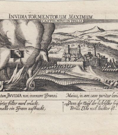
Meisner, Castelnovo di Porto, 1678
60,00 €Meisner, Castelnovo di Porto, 1678 è una veduta tratta dall’edizione del 1678 della celebre Sciagraphia Cosmica.
Questa incisione in rame presenta margini e si trova in perfetto stato di conservazione.
- Sheet size: cm. 13×19 approx.
- Engraving size: cm. 10×15 approx.
- Support: Laid paper without watermark
- Condition: Excellent state of preservation

Meissonier, The Players, 1860
20,00 €I Giocatori è una xilografia realizzata da Meissonier nel 1860.
Questa opera è parte di un libro francese di metà Ottocento e presenta una misura della parte stampata di cm. 15×15 on a sheet of paper cm. 29×19.
La stampa è contenuta nella pagina del libro e presenta scritte attorno e al verso. Viene spedita l’intera pagina contenente la stampa, rendendo questo pezzo un’interessante aggiunta per collezionisti e appassionati.
- Sheet size: cm. 29×19
- Engraving size: cm. 15×15
- Support: Paper
- Condition: Excellent
Melazzo, Castello di Montecrescente, 1890
20,00 €Melazzo, Castello di Montecrescente It is a woodcut print made in 1890 by the engraver Barberis.
Questa opera è tratta da un testo italiano di fine Ottocento e presenta un’immagine di dimensioni cm. 11×13 circa, circondata da testo e con ulteriore testo al verso del foglio.
- Sheet size: cm. 26×18 approx.
- Support: Paper
- Condition: Excellent
The entire sheet containing the print will be shipped.
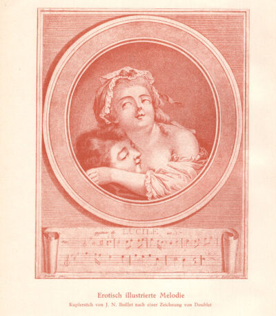
Melodia illustrata eroticamente Incisione di J. N. Boillet da un disegno di Doublet
40,00 €
Titolo: Melodia illustrata eroticamente
Incisione di J. N. Boillet da un disegno di Doublet
Era: XX secolo
Technique: cromolitografia
Dimensioni del foglio: cm 27×20
Dimensioni dell’immagine: cm 18×14
Support: carta liscia moderna, retro bianco
Condizioni: buone, con minime tracce del tempo ai margini

Menaggio, Como, 1890
15,00 €Menaggio, Como, 1890 It is a woodcut made by E. Bondier, un noto disegnatore e illustratore francese attivo nell’ultima parte del XIX secolo.
Questa stampa, tratta da un libro francese di fine ‘800, rappresenta una veduta animata di Menaggio, un incantevole comune sul Lago di Como.
- Sheet size: cm. 7x9 approx.
- Technique: Woodcut
- Condition: Excellent state of preservation
- Support: Paper
The print has been cut from the book and has writing on the back. The full page containing the print will be sent.

Mendelssohn Felix, 1850
30,00 €Mendelssohn Felix è un’incisione al bulino realizzata nel 1850, che ritrae il celebre compositore tedesco Jakob Ludwig Felix Mendelssohn Bartholdy.
Questa opera presenta le seguenti caratteristiche:
- Sheet size: cm. 23×14
- Engraving size: mm. 110×130
- Support: Paper
- Condition: Excellent
La stampa ha un retro bianco e rappresenta un’importante figura della musica romantica.
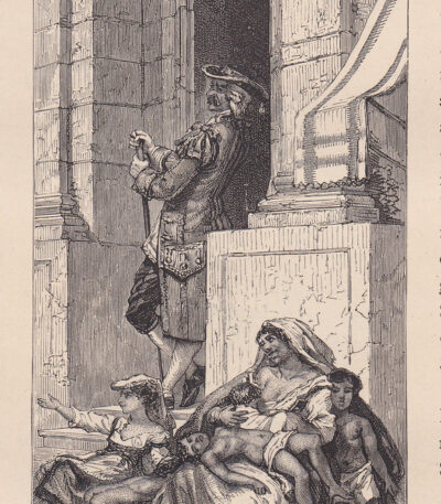
Mendicanti in via Toledo, Napoli, 1884
25,00 €Mendicanti in via Toledo, Napoli è un’incisione xilografica realizzata nel 1884, che ritrae una famiglia di mendicanti in una delle vie più celebri di Napoli.
This work is taken from the volume Naples and its surroundings di Rudolf Kleinpaul, e presenta scritte al verso che ne attestano l’autenticità.
- Sheet size: cm. 16×8 circa
- Support: Paper
- Condition: Excellent
Meno Haas (1752-1833), Scena storica, 1800-1820
30,00 €Historical scene It is an engraving made by Meno Haas tra il 1800 e il 1820.
This etching su carta non vergellata misura circa cm. 14×10 e rappresenta una scena che potrebbe essere un’illustrazione di un libro. Il retro è di colore bianco.
- Era: XIX
- Dimensions: Small
- Condition: Excellent
- Support: Paper
Meno Haas (1752-1833), Scena storica, 1800-1820
30,00 €Meno Haas (1752-1833) è un incisore tedesco noto per le sue opere storiche.
This historical scene, realizzata tra il 1800 e il 1820, è un’acquaforte su carta non vergellata che misura circa cm. 14×10.
L’opera potrebbe essere un’illustrazione per un libro, con un retro bianco che ne esalta la raffinatezza.
- Artist: Meno Haas
- Era: XIX
- Technique: Etching
- Condition: Excellent
- Dimensions: Small
- Support: Paper
Meno Haas (1752-1833), Scena storica, 1800-1820
30,00 €Meno Haas (1752-1833) presenta una Historical scene realizzata tra il 1800 e il 1820.
This etching on carta non vergellata misura circa cm. 14×10 e rappresenta una scena che potrebbe essere un’illustrazione di un libro, con un retro bianco.
- Sheet size: Small
- Condition: Excellent
- Support: Paper
Meno Haas (1752-1833), Scena storica, 1800-1820
30,00 €Meno Haas (1752-1833) è l’autore di questa Historical scene, realizzata tra il 1800 e il 1820.
Si tratta di un’incisione in etching su carta non vergellata, che misura circa cm. 14×10. Questa opera potrebbe essere un’illustrazione per un libro, con un retro bianco che ne esalta la raffinatezza.
- Sheet size: cm. 14×10 approx.
- Support: Unlaid paper
- Condition: Excellent
Meno Haas (1752-1833), Scena storica, 1800-1820
30,00 €Meno Haas (1752-1833) è l’autore di questa Historical scene, realizzata tra il 1800 e il 1820.
This etching su carta non vergellata misura circa cm. 14×10 e rappresenta una scena che potrebbe essere un’illustrazione di un libro, con un retro bianco.
- Sheet size: cm. 14×10 approx.
- Support: Unlaid paper
- Condition: Excellent
Meno Haas (1752-1833), Scena storica, 1800-1820
30,00 €Meno Haas (1752-1833), Scena storica è un’incisione realizzata tra il 1800 e il 1820.
This etching su carta non vergellata misura circa cm. 14×10 e rappresenta una scena che potrebbe essere un’illustrazione di un libro, con un retro bianco.
- Artist: Meno Haas, noto incisore e illustratore tedesco
- Era: 1800-1820
- Sheet size: Small
- Condition: Excellent
- Support: Unlaid paper

Meran, 1870
15,00 €Meran, 1870 è un’incisione xilografica che rappresenta una bella veduta decorativa della città di Merano.
Realizzata su legno di testa, questa opera misura mm. 130×155 e proviene da un libro tedesco.
- Sheet size: Small
- Condition: Excellent
- Support: Paper
- Notes: Almost no margins and writing on the back

Mercante di carne cotta di Napoli, 1796
60,00 €Mercante di carne cotta di Napoli è un’acquatinta acquarellata realizzata nel 1796.
Questa opera, firmata da Labrousse e Laroque, è tratta dall’Encyclopedie des voyages, che presenta un abbozzo storico delle usanze e delle abitudini.
- Sheet size: cm. 18×25 approx.
- Engraving size: cm. 11×15 approx.
- Support: Carta vergata con stemma in filigrana
- Condition: Excellent
Questa opera è rara e rappresenta un’importante testimonianza della cultura napoletana del XVIII secolo.

Mercante di Carni, A.H.Payne, 1862
30,00 €Mercante di Carni It is an engraving made by A.H. Payne nel 1862, che rappresenta un affascinante soggetto di vita quotidiana.
This work, entitled The Game Dealer, è una raffinata incisione in rame, eseguita con grande maestria.
- Sheet size: mm. 200×262
- Engraving size: mm. 130×152
- Support: Medium thickness paper with white backing
- Condition: Bella impressione, contrastata e rara

Mercante di frutta a Napoli, 1796
60,00 €Mercante di frutta a Napoli è un’incisione realizzata nel 1796, che rappresenta un mercante di frutti nella vivace città di Napoli.
This work is a acquatinta acquarellata di grande valore, proveniente dall’opera Encyclopedie des voyages, che illustra le usanze e le abitudini locali.
- Sheet size: cm. 18×25 approx.
- Engraving size: cm. 11×15 approx.
- Support: Carta vergata con stemma in filigrana
- Condition: Excellent

Fish Merchant, AHPayne, 1862
30,00 €Fish Merchant It is an engraving made by AH Payne in 1862, and very skilfully represented by HM Sorghi.
This work is an example of copper engraving, characterized by a nice impression and from a contrast remarkable, making it a rare and sought-after piece.
- Sheet size: mm. 200×262
- Engraving size: mm. 130×152
- Support: Medium thickness sheet with white backing
- Condition: Excellent

Sorbet Merchant in Florence, 1840
35,00 €Sorbet Merchant in Florence It is an engraving made in 1840 by ROUARGUE brothers, which features a lively scene of a sherbet vendor surrounded by characters in period costumes.
This work is taken from the volume Voyage d'Italie, northern part by Paul De Musset, and is characterised by delicate contemporary watercolouring.
- Sheet size: mm. 263×167
- Engraving size: mm. 163×117
- Support: Thick paper with white backing
- Condition: Excellent
Mercante di Stoffe, 1796
60,00 €Mercante di Stoffe è un’incisione realizzata nel 1796, che rappresenta una mercante napoletana di stoffe.
Questa opera è un’acquatinta acquarellata di grande valore storico, proveniente dall’Encyclopédie des voyages, illustrata con cura da Jacques Grasset Saint Sauveur.
- Sheet size: cm. 18×25 approx.
- Engraving size: cm. 11×15 approx.
- Support: Carta vergata con stemma in filigrana
- Condition: Excellent state of preservation

Mercoledì di Passione, Vita di Gesù, 1750-1800
15,00 €Mercoledì di Passione, Vita di Gesù è un’incisione realizzata tra il 1750 e il 1800, che rappresenta un momento significativo della vita di Gesù.
Questa opera, stampata in Francia, è caratterizzata da una tecnica di colored etching e presenta bordi rifilati, conferendo un aspetto elegante e curato.
- Sheet size: cm. 5,5×8 circa
- Condition: Excellent
- Support: Paper
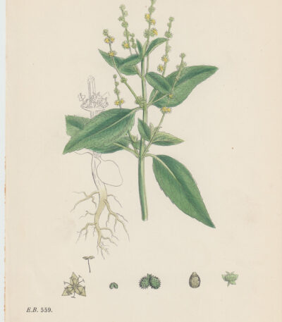
Mercorella comune, 1902
15,00 €Mercorella comune è una cromolitografia del 1902 che rappresenta la pianta Mercurialis annua.
This work is taken from the volume Botany Or Coloured Figures Of British Plants di J. Sowerby e altri, edito da John Boswell.
- Sheet size: cm. 16×25 approx.
- Condition: Good condition
- Support: Paper
Una bella e decorativa stampa, perfetta per gli amanti della botanica.
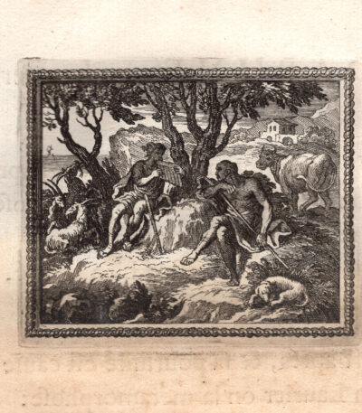
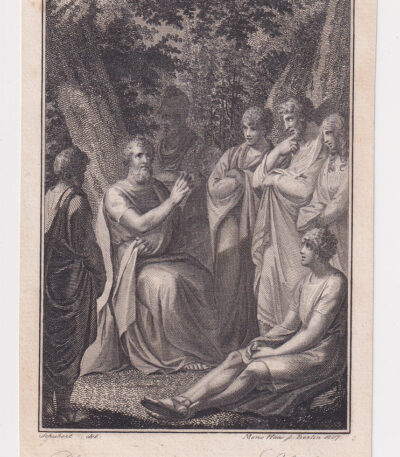
Mercurio e Argo, Metamorfosi di Ovidio, acquaforte del 1676
30,00 €Questa splendida incisione del 1676 proviene dalla prestigiosa edizione delle “Métamorphoses d’Ovide en rondeaux” Of Isaac de Benserade, un’opera di grande raffinatezza, commissionata da Luigi XIV per l’educazione del Delfino di Francia.
Descrizione dell’opera
-
Titolo: Stampa tratta da Les Métamorphoses d’Ovide en rondeaux
-
Author: Isaac de Benserade (testo), Le Clerc, Chauveau e Le Brun (incisioni)
-
Publisher: De l’Imprimerie Royale, Parigi, 1676
-
Technique: Acquaforte su carta vergellata (testo al verso)
-
Dimensions:
-
Incisione: cm 7,5 × 9 (alla battuta del rame)
-
Foglio: cm 27 × 20
-
Importanza storica e artistica
L’opera di Benserade è una delle più celebri reinterpretazioni seicentesche delle Ovid's Metamorphoses. La particolarità di questa edizione è il suo approccio didattico ed estetico: ogni mito è presentato attraverso una citazione in latino, una riscrittura in versi (i rondeaux, tipici componimenti poetici francesi) e un’incisione su rame che illustra la scena.
Le incisioni furono realizzate da tre importanti artisti dell’epoca:
-
Sébastien Le Clerc (1637-1714), incisore di corte del Re Sole
-
François Chauveau (1613-1676), celebre illustratore parigino
-
Charles Le Brun (1619-1690), pittore ufficiale di Luigi XIV
Questa stampa rappresenta un esempio straordinario di arte barocca, caratterizzata da un tratto preciso e dettagliato, che enfatizza la drammaticità e il dinamismo delle scene mitologiche.
Valore collezionistico
L’opera, stampata presso l’Imprimerie Royale, è una testimonianza del lusso e della raffinatezza della cultura francese sotto Luigi XIV. Le incisioni, realizzate con grande maestria, sono oggi oggetti di culto tra i collezionisti di ancient books, incisioni del XVII secolo And iconografia mitologica.
Un pezzo di altissimo valore storico e artistico, espressione della grande tradizione incisoria francese e dell’interesse del Re Sole per l’arte e la letteratura classica.
