
Shop
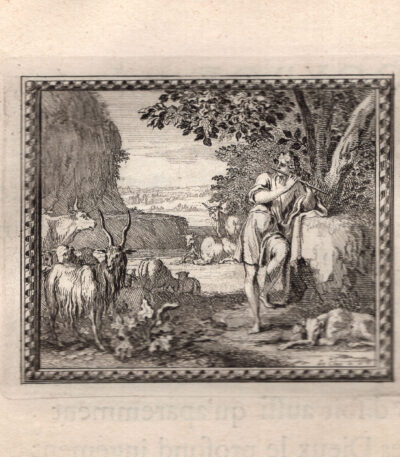
Mercurio e Batto, Metamorfosi di Ovidio, acquaforte del 1676
30,00 €Questa splendida incisione del 1676 proviene dalla prestigiosa edizione delle “Métamorphoses d’Ovide en rondeaux” Of Isaac de Benserade, un’opera di grande raffinatezza, commissionata da Luigi XIV per l’educazione del Delfino di Francia.
Descrizione dell’opera
-
Titolo: Stampa tratta da Les Métamorphoses d’Ovide en rondeaux
-
Author: Isaac de Benserade (testo), Le Clerc, Chauveau e Le Brun (incisioni)
-
Publisher: De l’Imprimerie Royale, Parigi, 1676
-
Technique: Acquaforte su carta vergellata (testo al verso)
-
Dimensions:
-
Incisione: cm 7,5 × 9 (alla battuta del rame)
-
Foglio: cm 27 × 20
-
Importanza storica e artistica
L’opera di Benserade è una delle più celebri reinterpretazioni seicentesche delle Ovid's Metamorphoses. La particolarità di questa edizione è il suo approccio didattico ed estetico: ogni mito è presentato attraverso una citazione in latino, una riscrittura in versi (i rondeaux, tipici componimenti poetici francesi) e un’incisione su rame che illustra la scena.
Le incisioni furono realizzate da tre importanti artisti dell’epoca:
-
Sébastien Le Clerc (1637-1714), incisore di corte del Re Sole
-
François Chauveau (1613-1676), celebre illustratore parigino
-
Charles Le Brun (1619-1690), pittore ufficiale di Luigi XIV
Questa stampa rappresenta un esempio straordinario di arte barocca, caratterizzata da un tratto preciso e dettagliato, che enfatizza la drammaticità e il dinamismo delle scene mitologiche.
Valore collezionistico
L’opera, stampata presso l’Imprimerie Royale, è una testimonianza del lusso e della raffinatezza della cultura francese sotto Luigi XIV. Le incisioni, realizzate con grande maestria, sono oggi oggetti di culto tra i collezionisti di ancient books, incisioni del XVII secolo And iconografia mitologica.
Un pezzo di altissimo valore storico e artistico, espressione della grande tradizione incisoria francese e dell’interesse del Re Sole per l’arte e la letteratura classica.
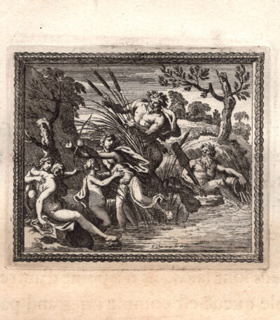
Mercurio e Siringa, Dio Pan, Metamorfosi di Ovidio, acquaforte del 1676
30,00 €Questa splendida incisione del 1676 proviene dalla prestigiosa edizione delle “Métamorphoses d’Ovide en rondeaux” Of Isaac de Benserade, un’opera di grande raffinatezza, commissionata da Luigi XIV per l’educazione del Delfino di Francia.
Descrizione dell’opera
-
Titolo: Stampa tratta da Les Métamorphoses d’Ovide en rondeaux
-
Author: Isaac de Benserade (testo), Le Clerc, Chauveau e Le Brun (incisioni)
-
Publisher: De l’Imprimerie Royale, Parigi, 1676
-
Technique: Acquaforte su carta vergellata (testo al verso)
-
Dimensions:
-
Incisione: cm 7,5 × 9 (alla battuta del rame)
-
Foglio: cm 27 × 20
-
Importanza storica e artistica
L’opera di Benserade è una delle più celebri reinterpretazioni seicentesche delle Ovid's Metamorphoses. La particolarità di questa edizione è il suo approccio didattico ed estetico: ogni mito è presentato attraverso una citazione in latino, una riscrittura in versi (i rondeaux, tipici componimenti poetici francesi) e un’incisione su rame che illustra la scena.
Le incisioni furono realizzate da tre importanti artisti dell’epoca:
-
Sébastien Le Clerc (1637-1714), incisore di corte del Re Sole
-
François Chauveau (1613-1676), celebre illustratore parigino
-
Charles Le Brun (1619-1690), pittore ufficiale di Luigi XIV
Questa stampa rappresenta un esempio straordinario di arte barocca, caratterizzata da un tratto preciso e dettagliato, che enfatizza la drammaticità e il dinamismo delle scene mitologiche.
Valore collezionistico
L’opera, stampata presso l’Imprimerie Royale, è una testimonianza del lusso e della raffinatezza della cultura francese sotto Luigi XIV. Le incisioni, realizzate con grande maestria, sono oggi oggetti di culto tra i collezionisti di ancient books, incisioni del XVII secolo And iconografia mitologica.
Un pezzo di altissimo valore storico e artistico, espressione della grande tradizione incisoria francese e dell’interesse del Re Sole per l’arte e la letteratura classica.
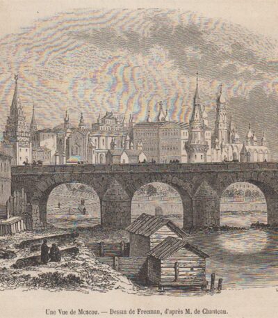
Mescou. Moscow Woodcut 1840-70
11,00 €Mescou. Moscow It is a woodcut made between 1840 and 1870, coming from the famous Picturesque Store.
This work was designed by Freeman and attributed to M. de Chanteau.
- Sheet size: cm. 30 x 21 approx.
- Engraving size: cm. 13 x 16 approx.
- Support: Light paper
- Condition: Excellent

Mexico, CF Delamarche, 1816
70,00 €Messico è una mappa del Golfo del Messico con le isole Antille, realizzata da C.F. Delamarche nel 1816.
This copper engraving is colored around the outline and is taken from the volume Petit Atlas Moderne ou Collection de Cartes Elementaires, dedicated to youth and published in Paris by Delamarche.
- Sheet size: cm. 21×27
- Technique: Burin
- Condition: Good
- Support: Paper

Messina, acquaforte acquarellata,1856
60,00 €Messina, 1856 it's a very fine burin engraving su acciaio acquarellata in epoca successiva, realizzata nel 1856.
This work is taken from the volume Picturesque journey in Italy by M. Paul De Musset, published in Paris by Morizot editeur.
- Sheet size: mm. 170×120
- Support: Heavy paper
- Condition: Perfect state of preservation

Messina, Underground Chapel, 1835
25,00 €Messina, Cappella sotterranea It is an engraving made at burin in 1835.
This work is taken from the volume Italy, Sicily, the Aeolian Islands, Elba Island, Sardinia, Malta, Calypso Island etc. by AUDOT père, published between 1835 and 1837.
- Sheet size: cm. 12×16
- Support: Medium thickness paper
- Condition: Good state of preservation

Messina, Charybdis, 1835
25,00 €Messina, Cariddi è un’incisione al bulino realizzata nel 1835, che rappresenta un’importante opera del periodo.
This engraving is taken from the volume Italy, Sicily, the Aeolian Islands, Elba Island, Sardinia, Malta, Calypso Island etc. by AUDOT père, published between 1835 and 1837.
- Sheet size: cm. 12×16 approx.
- Engraving size: cm. 12×16 approx.
- Support: Medium thickness paper
- Condition: Good state of preservation

Messina, Lighthouse, 1835
25,00 €Messina, Faro It is an engraving made at burin nel 1835, che rappresenta un’importante veduta della città di Messina.
This work is taken from the volume Italy, Sicily, the Aeolian Islands, Elba Island, Sardinia, Malta, Calypso Island etc. by AUDOT père, published between 1835 and 1837.
- Sheet size: cm. 12×16 approx.
- Support: Medium thickness paper
- Condition: Good state of preservation

Messina, The Port, 1850
40,00 €Messina, Il Porto è un’incisione realizzata nel 1850, che offre una splendida veduta del porto di Messina.
This work is taken from the volume The Classic Lands of Europe, Italy, Sicily and Greece.. by John Sherer, with steel etchings by such eminent artists as Allom, Bartlett and Leitch.
- Sheet size: cm. 22×32
- Engraving size: cm. 13×18
- Support: Strong paper
- Condition: Perfect
Questa incisione è caratterizzata da una rappresentazione nitida e animata, perfetta per gli amanti dell’arte e della storia.

Messina, the navy, 1835
25,00 €Messina, the navy It is a burin engraving made in 1835, which captures the beauty of the maritime landscape of Messina.
This work is taken from the volume Italy, Sicily, the Aeolian Islands, Elba Island, Sardinia, Malta, Calypso Island etc. by AUDOT père, published between 1835 and 1837.
- Sheet size: cm. 12×16
- Engraving size: cm. 12×16
- Support: Medium thickness paper
- Condition: Good state of preservation

Messina, Cathedral Square, 1835
30,00 €Messina, Piazza del Duomo è un’incisione realizzata al bulino nel 1835, che rappresenta un’importante veduta della città di Messina.
This work is taken from the volume Italy, Sicily, the Aeolian Islands, Elba Island, Sardinia, Malta, Calypso Island etc. by AUDOT père, published between 1835 and 1837.
- Sheet size: cm. 25×16 approx.
- Engraving size: cm. 25×16 approx.
- Support: Medium thickness paper
- Condition: Good state of preservation

Messina, Coat of Arms, 1871
15,00 €Messina, Coat of Arms It is a woodcut made in 1871, taken from the work The Hundred Cities of Italy for Ariodante Manfredi.
This print features an engraving measuring 8x9 cm, with small margins, on a light sheet.
- Sheet size: Small
- Condition: Excellent
- Support: Paper
- Notes: The print was removed from the book and has writing on the verso.

Messina, Earthquake of 1783, 1866
20,00 €Messina, Earthquake of 1783 It is a woodcut made by Louis Figuier in 1866, taken from the work The land and the sea.
This evocative and rare view depicts a significant historical event, capturing attention for its visual representation of the disaster.
- Sheet size: mm. 164×106 approx.
- Support: Paper
- Condition: Excellent

Metaponto, Ruins of the Temple, 1883
15,00 €Metaponto, Rovine del Tempio è un’incisione xilografica realizzata nel 1883, che rappresenta le rovine di un antico tempio a Metaponto.
This work is taken from the volume Picturesque Italy by J. Gourdault, published in Paris in 1883.
- Sheet size: mm. 103×78
- Margins: almost absent
- Support: Paper
- Condition: Excellent
La stampa è stata ritagliata dal libro e presenta scritte sul retro, rendendola un pezzo decorativo e grazioso per gli amanti dell’arte e della storia.
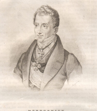
Metternich, 1838
20,00 €Metternich è un’incisione realizzata da Filippo Morghen nel 1838, incisa su rame.
This half-length portrait is taken from the volume The Picturesque Omnibus, pubblicato a Napoli nel 1839.
L’opera presenta scritte sul retro e si distingue per la sua finezza e dettagli.
- Sheet size: cm. 11×12 alla battuta
- Support: Copper
- Condition: Excellent state of preservation
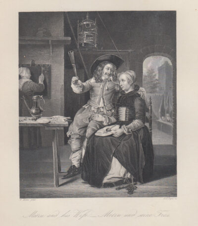
Metzu and his wife, G.Metzu, 1840-50
20,00 €Metzu e sua moglie è un’acquaforte realizzata da G. Metzu tra il 1840 e il 1850.
Questa stampa è pubblicata nel volume Payne's Royal Dresden Gallery da A.H. Payne e W. French, edito a Dresda, Lipsia e Londra.
- Sheet size: cm. 21×27
- Engraving size: cm. 21×27
- Technique: Etching
- Support: Strong paper
- Condition: Excellent

Courts' Mezzana, 1865
15,00 €Mezzana Courts It is an engraving made in 1865, representing the Mezzana Courts Bridge.
This woodcut is from the Chorographic Dictionary of Italy by Prof. Amato Amati, an illustrated work with approximately 1000 colored municipal weapons, published in Milan by Vallardi Editore.
- Sheet size: mm. 220×140
- Technique: Woodcut
- Condition: Good
- Support: Paper
Note: The engraving was cut from the book and has writing on the back.
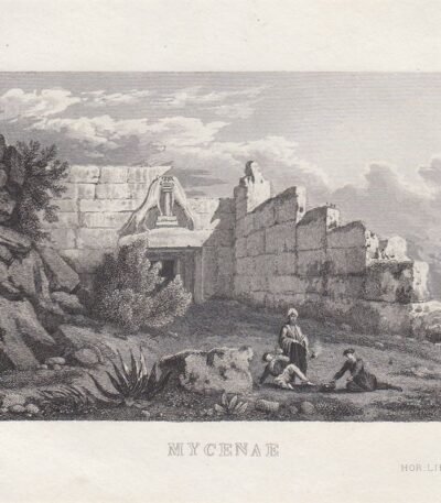
Micene, Grecia, C.Frommel, 1829
25,00 €Micene, Grecia It is an engraving made by Carl Frommel In the 1829.
This work is an etching on medium paper, part of the series 50 Bilder zu Virgils Heneide…, featuring high-quality engravings.
- Sheet size: cm. 13×22 approx.
- Engraving size: cm. 7×10 approx.
- Support: Paper
- Condition: Excellent state of preservation
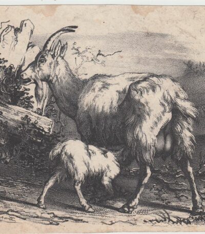
Michel Delaporte, Goats, 1850 ca
20,00 €Goats è una litografia realizzata da Pierre Michel Delaporte intorno al 1850.
Questo affascinante lavoro, firmato in basso a sinistra, rappresenta un esempio della maestria dell’artista nel catturare la bellezza della natura.
- Sheet size: cm. 12×15 approx.
- Technique: Lithography
- Condition: Buone, con alcuni piccoli fori
- Support: Unlaid paper

Michel Jamar (Francia) exlibris
10,00 €Exlibris di Michel Jamar è un’opera incisoria di origine francese, caratterizzata da un soggetto di natura erotica.
Made with the technique of woodcut, questo exlibris presenta un formato compatto e affascinante.
- Sheet size: cm. 10×13
- Support: Light paper
- Condition: Excellent
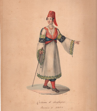
Michela De Vito, Costume di Carafagreci, (Carfizzi, Catanzaro) acquarello originale, 1820-30
180,00 €Acquarello su carta pesante misura cm.29×22. Ottime condizioni.
L’immagine mostra un acquerello storico intitolato “Costume di Carafagreci”, che raffigura l’abito tradizionale femminile di Carfizzi, un comune in provincia di Catanzaro, Calabria (all’epoca parte del Regno di Napoli).
Dettagli del Costume e dell’Opera
Artista: L’opera è attribuita all’artista Michela De Vito, attiva a Napoli nel XIX secolo e nota per i suoi disegni di costumi popolari.
Provenienza: Il costume è specifico di Carfizzi (Carafagreci nell’ortografia antica), un paese con una comunità arbëreshe (italo-albanese).
Caratteristiche: L’abito è caratterizzato da una lunga gonna bianca, un corpetto ricamato e, in particolare, un copricapo distintivo chiamato keza (o nabsa in alcuni dialetti locali). Questo tipo di costume “da festa” si differenzia in base alla zona della Calabria, nei tessuti e nei colori.
Tecnica: L’opera è un acquerello su cartoncino ed è parzialmente firmato dall’artista.
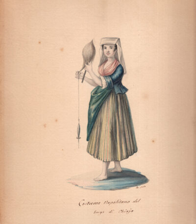
Michela De Vito, Donna di Chiaia, acquarello originale, 1820-30
180,00 €Acquarello su carta pesante misura cm.29×22. Ottime condizioni.
L’immagine mostra un acquerello intitolato Costume Napolitano del borgo di Chiaja, realizzato da Michela De Vito intorno al 1820. L’opera fa parte di una serie di disegni sui costumi tradizionali del Regno di Napoli, molto popolari all’epoca.
Dettagli dell’Opera
Artista: Michela De Vito (attiva a Napoli nella prima metà del XIX secolo).
Titolo: Costume Napolitano del borgo di Chiaja.
Datazione: Circa 1820.
Tecnica: Acquerello su cartoncino
Soggetto: L’immagine ritrae una donna del popolo, o popolana, che indossa abiti tradizionali dell’epoca nel quartiere di Chiaia, a Napoli, mentre fila.
Michela De Vito fu un’artista raffinata, nota per i suoi acquerelli e gouache che documentavano le scene di costume dell’epoca, spesso confuse con quelle del parente Camillo De Vito. Questi lavori erano molto richiesti dai viaggiatori del Grand Tour come souvenir e testimonianze della cultura locale.
Tecnica: L’opera è un acquerello su cartoncino ed è parzialmente firmato dall’artista.
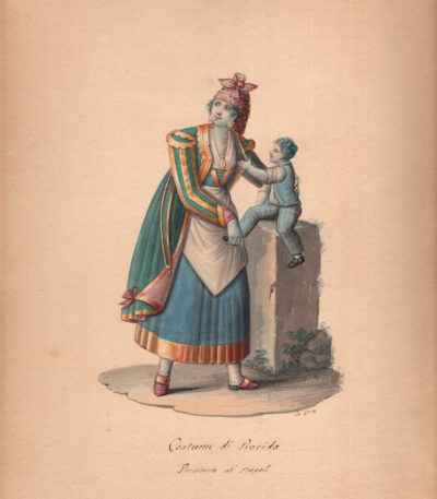
Michela De Vito, Donna di Procida, acquarello originale, 1820-30
180,00 €Acquerello originale intitolato “Costume di Procida” con la didascalia “Provincia di Napoli”. L’opera è stata creata dall’artista ottocentesca Michela De Vito intorno al 1820-1830.
Acquarello su carta pesante misura cm.29×22. Ottime condizioni.
Artista: Michela De Vito, un’artista attiva a Napoli nei primi decenni del XIX secolo, nota per le sue raffinate illustrazioni di costumi popolari.
Soggetto: L’illustrazione ritrae una donna di Procida con un bambino, entrambi vestiti con abiti tradizionali dell’epoca.
Stile dell’Abito: Il costume femminile si distingue per i suoi colori vivaci, le sete sgargianti e il taglio che mostra influenze orientali, un riflesso dei legami commerciali marittimi dell’isola con il mondo ottomano.
Tecnica: L’opera è un acquerello su cartoncino ed è parzialmente firmato dall’artista.
L’opera fa parte di una serie di disegni e acquerelli che documentano i costumi tradizionali del Regno di Napoli in quel periodo. Esemplari simili sono spesso disponibili in vendita presso gallerie d’arte e case d’asta specializzate in stampe antiche e opere del XIX secolo.
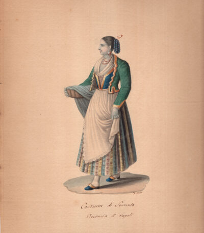
Michela De Vito, Donna di Sorrento, acquarello originale, 1820-30
180,00 €Acquarello su carta pesante misura cm.29×22. Ottime condizioni.
L’immagine mostra un acquerello intitolato Costume di Sorrento, realizzato da Michela De Vito intorno al 1820. L’opera fa parte di una serie di disegni sui costumi tradizionali del Regno di Napoli, molto popolari all’epoca.
Dettagli dell’Opera
Artista: Michela De Vito (attiva a Napoli nella prima metà del XIX secolo).
Titolo: Costume di Sorrento Provincia di Napoli.
Datazione: Circa 1820.
Tecnica: Acquerello su cartoncino
Soggetto: L’immagine ritrae una donna del popolo, o popolana, che indossa abiti tradizionali dell’epoca, a Sorrento.
Michela De Vito fu un’artista raffinata, nota per i suoi acquerelli e gouache che documentavano le scene di costume dell’epoca, spesso confuse con quelle del parente Camillo De Vito. Questi lavori erano molto richiesti dai viaggiatori del Grand Tour come souvenir e testimonianze della cultura locale.
Tecnica: L’opera è un acquerello su cartoncino ed è parzialmente firmato dall’artista.
