
Shop

Pierluigi Gerosa (Rogeno, Como 1922-2011)
10,00 €Pierluigi Gerosa è un artista noto per il suo stile unico e la sua abilità nella woodcut.
Nato a Rogeno, Como, nel 1922, Gerosa ha lasciato un’impronta significativa nel panorama artistico italiano fino alla sua morte nel 2011.
- Sheet size: mm. 75×95
- Support: Light paper
- Condition: Excellent

Pierre Corneille, 1850
20,00 €Pierre Corneille è un’incisione realizzata da J. Gigoux e incisa da Levy nel 1850.
Questa opera, che ritrae il celebre commediografo in una caratteristica posa, è stata pubblicata da Ernest Bourdin a Parigi.
- Sheet size: cm. 90×135 circa
- Technique: Burin
- Support: Thick paper
- Condition: Good

Pierre Corneille, 1873
30,00 €Pierre Corneille It is a watercolour etching made in 1873, depicting the famous French playwright.
This engraving is part of the volume Oeuvres de P. Corneille, theater complet, published in Paris in 1873.
- Sheet size: cm. 26×17 approx.
- Engraving size: cm. 9×17 approx.
- Support: White backed paper
- Condition: Excellent state of preservation
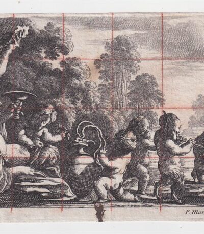
Pierre Mariette Baccanale, XVII secolo
50,00 €Baccanale è uno studio per un affresco realizzato da Pierre Mariette in the 17th century.
Questo lavoro, firmato in basso a destra con la sigla P.Mariette e monogrammato FL, è un esempio significativo dell’arte del periodo.
- Sheet size: mm. 102×222 alla battuta del rame
- Technique: Bulino e matita rossa su carta vergellata
- Condition: Foglio un po’ maltrattato
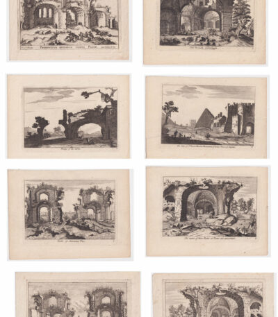
Pierre Mariette, 8 views of Rome, 18th century
120,00 €8 Vedute di Roma è un insieme di incisioni realizzate da Pierre Mariette nel XVIII secolo, che rappresentano monumenti e rovine iconiche della città eterna.
Le vedute includono il Colosseo, il ponte delle Sabine, la piramide di Cestius, i bagni di Antonino Pio, le rovine del tempio della Pace e le terme di Antonino Pio.
- Sheet size: cm. 18×24 approx.
- Engraving dimensions: cm. 14×20 approx.
- Technique: Etching and burin
- Support: Laid paper
- Condition: Excellent
Cinque delle stampe presentano il titolo in inglese, mentre le altre tre sono in latino, con la dicitura in basso Chez P. Mariette avec Privilege du Roy.
Pierre Moreau, Esequie in Italia, 1760 ca.
60,00 €Esequie in Italia è un’incisione realizzata da Pierre Moreau, un artista francese attivo nel XVIII secolo.
Questa opera, datata circa 1760, è un esempio significativo della sua abilità nell’arte dell’acquaforte.
- Sheet size: cm. 13×19 approx.
- Technique: Etching
- Support: Carta vergellata, incollato ai margini ad altro supporto cartaceo
- Condition: Buone, con mancanze ai margini superiori
Pierre Moreau, Ships in the Port, ca. 1760
60,00 €Ships in the port It is an engraving made by Pierre Moreau around 1760.
This work, which represents a suggestive scene of moored ships, is executed in etching on laid paper.
- Sheet size: cm. 13×19 approx.
- Support: Glued at the edges to another paper support
- Condition: Excellent condition

Pierre Mortier (1661-1711), Plagues of Egypt, 1700
40,00 €Plagues of Egypt It is an engraving made by Pierre Mortier in 1700, which illustrates two episodes from the Old Testament: the third plague of Egypt, represented by insects, and the fourth plague, which shows mosquitoes or locusts.
This work is part of the publication History of the old and new Testaments, enriched with over four hundred burin engravings, published in Antwerp by Pierre Mortier.
- Sheet size: cm. 36×23 plus irregular margins
- Technique: Burin
- Condition: Good
- Support: Laid paper

Pierre Paul Prud'hon, L'Innocence, Louvre, 1850
30,00 €L’Innocence It is a lithograph made by Pierre Paul Prud’hon nel 1850, conservata presso il Louvre.
This work, which measures cm. 13×16 on a sheet of paper cm. 21×31, presenta alcune sporadiche macchie di foxing ai margini, ma ciò non compromette l’immagine.
- Artist: Pierre Paul Prud’hon
- Technique: Lithography
- Condition: Excellent
- Support: Strong paper
- Price: €30,00

Pierre Vander AA, Plan of the city of Nola, 1729
Map of the city of Nola It is an engraving made by Pierre Vander AA in 1729, taken from the Thesaurus antiquitatum et historiarum Italiae.
This detailed map represents the city of Nola, located in the province of Naples, and was created using the etching technique on laid paper.
- Sheet size: cm. 40×24 approx.
- Engraving size: cm. 18×24 approx.
- Support: Laid paper
- Condition: Excellent
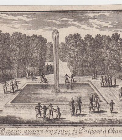
Pierre-Jean Mariette, Chantilly
40,00 €Pierre-Jean Mariette, Le Bassin quarré-long près le Potager a Chantilly It is an engraving made in the 18th century.
This work is a fine example of Mariette's mastery, signed at the bottom with In Paris chez I.Mariette rue S.Jacques a la Victoire with Privilege du Roy.
- Sheet size: mm. 112×175 at the copper edge
- Technique: Burin
- Condition: Excellent condition
- Support: Laid paper
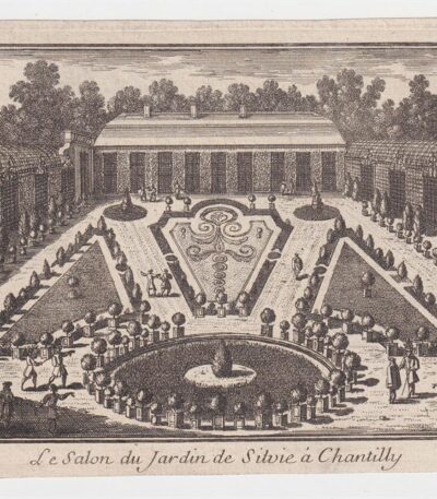
Pierre-Jean Mariette, Chantilly
40,00 €Le Salon du Jardin de Silvie in Chantilly It is an engraving made by Pierre-Jean Mariette in the 18th century.
This work, performed with the technique of Burin, represents a fascinating glimpse of the Chantilly garden.
- Sheet size: mm. 122×195 at the copper edge
- Condition: Excellent condition
- Support: Laid paper
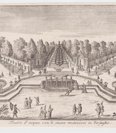
Pierre-Jean Mariette, Versailles
40,00 €Pierre-Jean Mariette, Versailles It is an engraving made by Pierre-Jean Mariette in the 18th century.
This work, entitled Water Theater with the new mutations in Versailles, is performed with the technique of Burin on laid paper.
- Sheet size: mm. 162×222 at the copper edge
- Condition: Excellent condition

Pierrot, 18th century
40,00 €Pierrot è una litografia acquarellata d’epoca che rappresenta i personaggi della commedia tedesca, risalente al 18th century.
This work is made on laid paper di medio spessore e presenta una scritta in tedesco con note editoriali nella parte inferiore.
- Sheet size: cm. 26×18 approx.
- Condition: Excellent
- Technique: Lithography
- Dimensions: Small
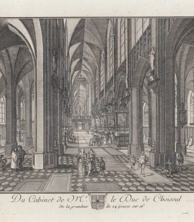
Pieter Neefs (1578-1661), Bashan, 1771
30,00 €Pieter Neefs (1578-1661), Bashan, 1771 It is an engraving made by Pieter Neefs, a Flemish painter known for his architectural church interiors.
This work is part of the Cabinet of the Duke of Choiseul, an important collection of engraved prints from works by the Duc de Choiseul, published in 1771 by Pierre-François Basan.
- Sheet size: cm. 30×20 approx.
- Engraving size: cm. 14×21 approx.
- Technique: Etching
- Support: Laid paper
- Condition: Excellent

Peter Paul Rubens, St. Catherine, 1620, 19th century
60,00 €St. Catherine It is an engraving made by Peter Paul Rubens in 1620, reproduced by Amand Durand in the 19th century.
This work is a significant example of Flemish art, reflecting Rubens' mastery in portraying sacred figures.
- Sheet size: cm. 28×19 approx.
- Engraving size: cm. 23×15 approx.
- Support: Laid paper
- Condition: Excellent
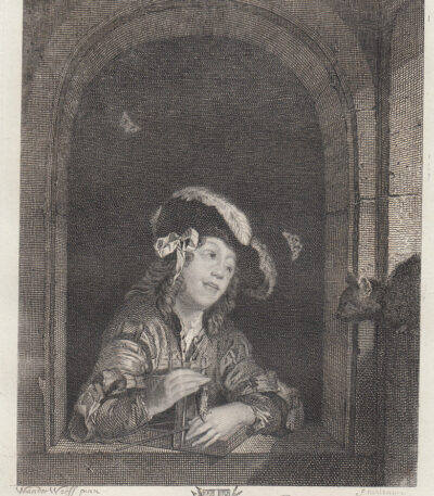
Pieter van der Werff, Bashan, 1771
30,00 €Pieter van der Werff, Bashan, 1771 It is an engraving made by Pierre-François Basan, published in 1771.
This work is part of the Cabinet of the Duke of Choiseul, an important collection of engraved prints based on the paintings of the Duc de Choiseul.
- Sheet size: cm. 30×20 approx.
- Engraving size: cm. 14×12 approx.
- Technique: Etching
- Support: Laid paper
- Condition: Excellent condition
Pieter van der Werff (1665 – 1722) was a Dutch Golden Age painter, known for his collaboration with his brother Adriaen van der Werff.
Pieter van der Werff, Bashan, 1771
30,00 €Pieter van der Werff, Bashan, 1771 It is an engraving made by Pierre-François Basan, published in 1771.
This work is part of the Cabinet of the Duke of Choiseul, un’importante raccolta di stampe incise basate sui dipinti del duca.
- Sheet size: cm. 30×20 approx.
- Engraving size: cm. 13×10 approx.
- Technique: Etching
- Support: Laid paper
- Condition: Excellent
Pieter van der Werff (1665 – 1722) è noto come un pittore dell’età d’oro olandese, che ha collaborato con suo fratello Adriaen van der Werff.
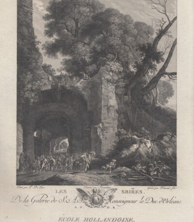
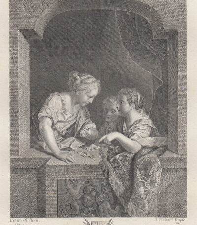
Pieter van Laer called Bamboccio, The Servants, 1786
50,00 €Pieter van Laer called the Bamboccio, The Servants It is an engraving made in 1786.
This work is an etching on laid paper without watermark, measuring cm. 24×37, including the editorial frame.
- Taken from: Galerie Du Palais Royal, with works from different schools
- Description: Includes an abbé of the painters' lives and a historical description of each painting, by Mr l'abbé de Fontenai
- Dedication: To HSH Monseigneur le Duc d'Orléans, Premier Prince du Sang
- Published by: J. Couche, Paris, 1786
- Condition: Excellent condition, nice proof with good contrast
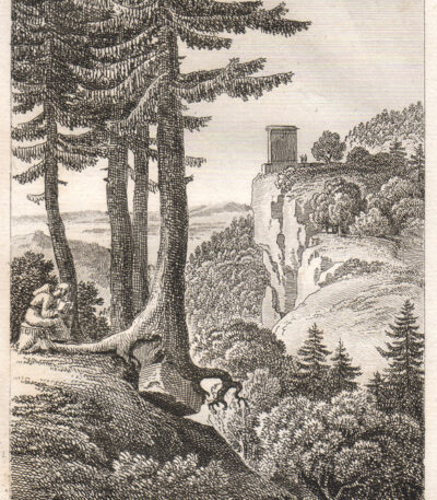
Pietramarina, (Firenze), 1819
25,00 €Pietramarina, un’incisione realizzata da TO THE CASTELLAN nel 1819, rappresenta il famoso Masso del diavolo.
Questa acquaforte è tratta dal volume Letters on Italy, published in Paris by A. Nepveu.
- Size of the joke: mm. 105×140
- Margins: Piccoli margini irregolari
- Back: White
- Condition: Excellent
Antoine-Laurent Castellan, nato a Montpellier nel 1772 e morto a Parigi nel 1838, è stato un noto pittore, scrittore e incisore. Decorato della Legion d’onore e membro dell’Accademia di Belle Arti, ha realizzato opere principalmente dedicate ai paesaggi, contribuendo a libri illustrati come View of Italy And View of the Alps.
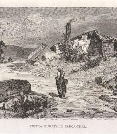
Stonewall, 1876
15,00 €Stonewall, 1876 It is a woodcut engraving representing the beauty of the Sarca-Thal.
Made in 1876, this work is taken from the volume Italian by K.Stieler and W.Kaden, published in Stuttgart.
- Sheet size: mm. 186×89
- Condition: Excellent condition
- Support: Light sheet, cut from the book
- Notes: Almost no margins and writing on the back
This engraving is not only a decorative piece, but also an important historical testimony.
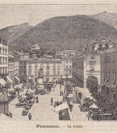
Pietrasanta, The Doors, 1890
20,00 €Pietrasanta, The Doors It is a woodcut print made in 1890, depicting the city of Pietrasanta, located in the province of Lucca.
This work is taken from Illustrated geographical Italy by P. Premoli and features a descriptive text around the image and the back.
- Sheet size: cm. 12×10 approx.
- Technique: Woodcut
- Condition: Excellent
- Support: Light paper
The print has been removed from the book and will be shipped with the full page, including the text on the verso.
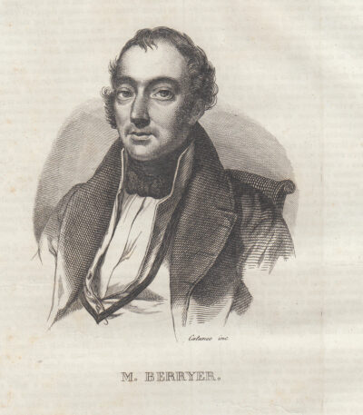
Pietro Antonio Berryer, 1841
15,00 €Pietro Antonio Berryer It is a copper engraving made in 1841, taken from the work Picturesque Omnibus.
This print, which measures approximately cm. 10×15, è stata estratta dal libro e presenta testo sia intorno che al verso.
- Sheet size: Small
- Condition: Excellent
- Support: Paper
Pierre-Antoine Berryer, noto come “Berryer figlio”, nacque il 4 gennaio 1790 a Parigi e morì il 29 novembre 1868 a Augerville-la-Rivière. È ricordato come un giurista e politico francese, sepolto nella stessa località.
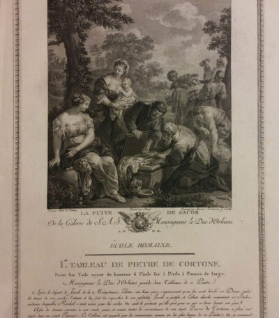
Pietro Da Cortona (Pietro Berrettini), Jacob's Flight, 1786
70,00 €Jacob's Escape It is an engraving made by Peter From Cortona (Pietro Berrettini) in the 1786.
This work is an etching on laid paper without watermark, from the Gallery of the Palais Royal, which collects works from different artistic schools.
- Sheet size: cm. 24×37 approximately (including the editorial frame)
- Condition: Excellent condition, nice proof with good contrast
- Support: Laid paper
