
Shop
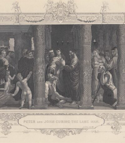
Peter and John heal the lame man.
25,00 €Peter and John heal the lame man It is an engraving made by J. Rogers, inspired by the famous healing of the paralytic.
This work is part of the Scripture Gallery of Engraving and was published by John Tallis & Company, London & New York, between 1830 and 1850.
- Sheet size: cm. 27×21 approx.
- Engraving size: cm. 15×11 approx.
- Support: Heavy paper
- Condition: Excellent condition, white back, with editorial frame with vignettes
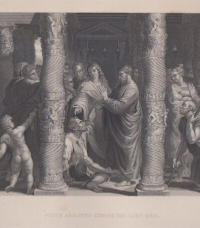
Peter and John, Raphael Sanzio, 1846
30,00 €Pietro e Giovanni è un’incisione realizzata da Raffaello Sanzio nel 1846, che rappresenta la scena in cui Pietro e Giovanni curano un zoppo.
This work is taken from The Imperial Family Bible, old and new Testaments, published by Blackie and Son in Glasgow.
- Sheet size: cm. 25×35 approx.
- Engraving size: cm. 15×20 approx.
- Support: Strong paper
- Condition: Excellent condition

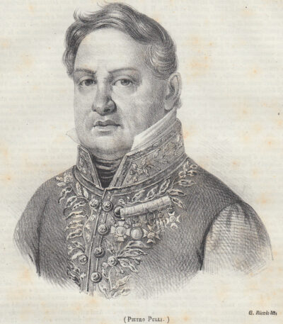
Pietro Pacecco XI viceroy of Naples, 1846
15,00 €Pietro Pacecco XI Viceré di Napoli è una litografia realizzata nel 1846, tratta dal volume Picturesque Polyorama of Naples.
Questa opera rappresenta D. Pietro Cardinal Pacecco, un’importante figura storica che ha ricoperto il ruolo di viceré di Napoli.
- Size of the joke: cm. 10×10
- Support: Paper, back printed
- Condition: Excellent
La stampa è stata estratta dal libro e presenta scritte al retro.
Pietro Pacecco, noto anche come Pedro Pacheco Ladrón de Guevara, è stato un cardinale e vescovo cattolico spagnolo, che ha avuto un ruolo significativo nella storia di Napoli.
Peter Pulli, 1842
15,00 €Peter Pulli, 1842 it's a lithographic printing which represents an important work by the Italian composer Pietro Pulli, published in 1842.
This print is from Picturesque Polyorama, a periodical work aimed at spreading useful knowledge to all classes of society.
- Printed part dimensions: cm. 14×16
- Margins: almost absent
- Support: Paper
- Condition: Excellent
The print is contained within the book page and has writing around and on the back. The entire page containing the print is shipped.
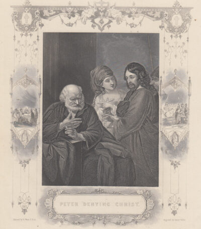
Pietro rinnega Cristo 1830
25,00 €Pietro rinnega Cristo It is an engraving made by B. West and engraved by Henry Wallis in the period 1830-1850.
This work is part of the Scripture Gallery of Engraving and it was published by John Tallis & Co. of London and New York.
- Sheet size: cm. 27×21 approx.
- Engraving size: cm. 15×11 approx.
- Support: Heavy paper
- Condition: Ottime condizioni, retro bianco
Questa incisione è caratterizzata da una cornice editoriale con vignette, rendendola un pezzo affascinante per collezionisti e appassionati di arte.
Pietro Scoppetta, Two Oriental Women, 19th-20th century
420,00 €Two oriental women It is a monochrome watercolor made by Peter Scoppetta in the 19th-20th century.
This work, signed lower left, is of fine workmanship and measures approximately cm. 15×28.
- Artist: Pietro Scoppetta (Amalfi, 15 February 1863 – Naples, 10 February 1920)
- Technique: Watercolor
- Condition: Excellent
- Support: Paper
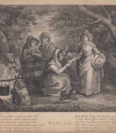
Pietro Vedovato (1774–1847) Marian
40,00 €Marian It is an engraving made by Pietro Vedovato (1774–1847), noto incisore italiano.
Questa opera è un’acquaforte su carta di medio spessore, con una dimensione di cm. 24×17 al margine dell’immagine e presenta una didascalia in inglese.
- Sheet size: cm. 24×17 approx.
- Technique: Etching
- Condition: Fair condition
- Support: Medium thickness paper

Petersburg, Alexander Column, 1850
25,00 €Petersburg, Alexander Column It is an engraving made in 1850, representing the architectural beauty of St. Petersburg.
This etching It measures 10 x 7 cm, excluding margins, and is printed on medium-thickness paper with a white back.
- Sheet size: Small
- Condition: Excellent
- Support: Paper

Pietroburgo, Palazzo Imperiale d’Inverno, 1866
25,00 €Incisione xilografica su legno di testa che rappresenta una veduta della città.
This work is taken from Picturesque Emporium, edito da Sonzogno a Milano nel XIX secolo.
- Dimensioni della immagine: cm. 21×16 approx.
- Margins: presenti
- Support: Carta leggera con scritto al verso in parte visibile.
- Condition: Excellent
La stampa è stata ritagliata dal libro e presenta scritte sul retro, rendendola un pezzo raro e affascinante per collezionisti.
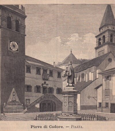
Pieve di Cadore, Square, 1890
20,00 €Pieve di Cadore, Square it's a woodblock print created in 1890, based on a late nineteenth-century Italian text.
This work presents a large-sized image cm. 9×12 approximately, surrounded by text and with additional text on the back of the sheet. The complete sheet measures cm. 30×20 and will be shipped in its entirety.
- Sheet size: cm. 30×20
- Image size: cm. 9×12
- Support: Paper
- Condition: Excellent
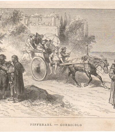
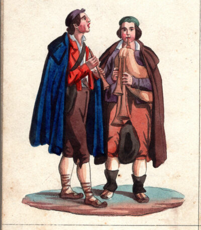
Pifferai, Corricolo, 1876
15,00 €Pifferai, Corricolo è un’incisione xilografica realizzata nel 1876, che rappresenta una bella veduta con zampognari.
This work is taken from the volume Promenades in Italy dell’Abbé Rolland, pubblicato a Tours.
- Sheet size: mm. 130×76 circa
- Support: Head wood
- Condition: Excellent condition
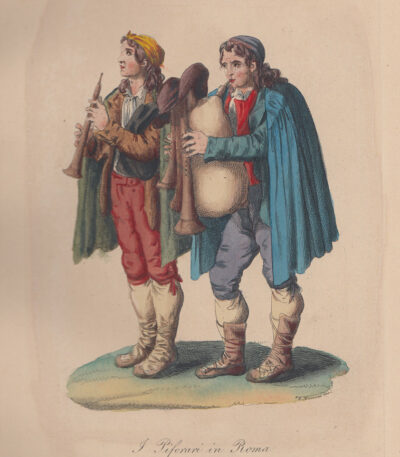
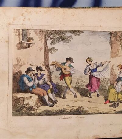
Pipers, Bagpipers, 1840
70,00 €Pifferai, Zampognari è un’acquaforte acquarellata realizzata nel 1840, tratta dall’opera Costumi di Roma e suoi contorni, disegnata da vari artisti e incisa da Salvatore Marroni.
Questa pregevole opera è stata pubblicata a Roma presso l’editore e calcografo Tommaso Cuccioni, situato in Via della Croce N.88.
- Sheet size: cm. 32×22
- Support: Medium thickness paper with white backing
- Condition: Excellent
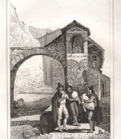
Pifferari nei Dintorni di Roma, 1834
35,00 €Pifferari nei Dintorni di Roma è un’incisione al bulino realizzata nel 1834, che cattura un momento affascinante della tradizione musicale italiana.
L’opera rappresenta tre zampognari davanti a una cappella votiva, intenti a suonare la novena, un’immagine evocativa della cultura popolare.
Taken from the volume Italy picturesque tableau historique and description of Italy… di M. De Norvins e C. Nodiers, pubblicato a Parigi nel 1834, questa incisione è un esempio pregevole dell’arte dell’epoca.
- Sheet size: mm. 120×180 circa
- Engraving size: mm. 120×180 circa
- Support: Light paper
- Condition: Excellent state of preservation
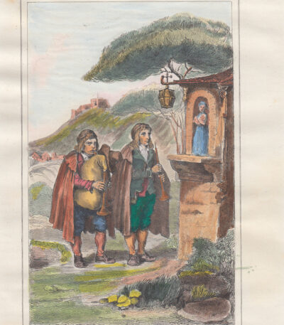
Pifferari, Costumi di Roma, 1834
30,00 €Pifferari, Costumi di Roma it is an engraving on burin acquarellata a mano, realizzata nel 1834.
Questa opera rappresenta due zampognari davanti a una cappella votiva, intenti a suonare la novena.
It is taken from the work Italy picturesque tableau historique and description of Italy… di M. De Norvins e C. Nodiers, pubblicata a Parigi nel 1834.
- Sheet size: mm. 113×180 più margini
- Support: Light paper
- Condition: Excellent
Pifferari, Zampognari, acquarello
40,00 €Pifferari, Zampognari it's a beautiful watercolor of exquisite workmanship, created by an anonymous author and datable to the first half of the 19th century.
This little masterpiece, measuring approximately 7x10 cm, is made on cardboard con retro bianco, su cui sono presenti scritte a penna.
- Condition: Excellent state of preservation
- Colors: Alive and bright

Pigliamosche, 1875
25,00 €Pigliamosche, also known as White Collared Flycatcher, è una litografia acquarellata d’epoca realizzata nel 1875.
This work is taken from A HISTORY OF BIRDS OF EUROPE by Charles Robert Bree, published in London in the same year.
- Sheet size: cm. 16×25 approx.
- Support: Strong paper with white back
- Condition: Excellent condition
Pilot, Royco, Game of the Goose, 1951
30,00 €Gioco dell’Oca Royco è un’affascinante stampa realizzata nel 1951, offerta come omaggio con l’acquisto di due sacchi di zuppa di verdure Royco.
Questa opera, di autore sconosciuto, è stampata in offset a colori su carta leggera e presenta un retro bianco.
- Sheet size: cm. 68×54
- Condition: Good condition
- Support: Light paper

Pindus, Greece, C.Frommel, 1829
25,00 €Pindus, Greece It is an engraving made by Carl Frommel in 1829.
This work is part of the volume 50 Bilder zu Virgils Heneide…, featuring high-quality engraving.
- Sheet size: cm. 13×22 approx.
- Engraving size: cm. 7×10 approx.
- Support: Medium paper
- Condition: Excellent state of preservation
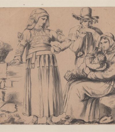
Pinelli Bartolomeo (attr.), Studio per la tavola dei Costumi di Filettino, acquarello
250,00 €Autore: attribuito a Bartholomew Pinelli (Roma 1781 – 1835)
Titolo: Studio per la tavola dei Costumi di Filettino
Epoca: prima metà XIX secolo
Tecnica: penna, inchiostro bruno e lavis su carta
Supporto: carta antica
Dimensioni: circa 15 × 24 cm
Descrizione
Raro e interessante disegno attribuito al celebre artista romano Bartolomeo Pinelli, noto per le sue incisioni dedicate alla vita popolare, ai costumi regionali e alle tradizioni dell’Italia centrale.
Il foglio raffigura una scena familiare con tre figure: una giovane donna in piedi con costume tradizionale, un uomo con cappello appoggiato al bastone e una madre seduta che tiene tra le braccia il proprio bambino. A sinistra compare una cesta appoggiata su un basamento in pietra.
La composizione corrisponde alla celebre tavola dei Costumi di Filettino incisa da Pinelli. Tuttavia il disegno presenta una resa più sintetica, concentrata sulle figure e priva dello sfondo paesaggistico e dei complessi tratteggi calcografici presenti nella stampa finale.
L’opera è realizzata con tratto rapido e sicuro a penna e inchiostro bruno, con eleganti passaggi di lavis che modellano i volumi delle figure e conferiscono profondità alla scena.
Considerazioni storico-artistiche
Per impostazione grafica e tecnica esecutiva, il foglio può essere interpretato come:
studio preparatorio o modello di lavoro per l’incisione, oppure
disegno di ambito pinelliano realizzato in relazione alla serie dei costumi popolari.
Il tratto spontaneo e la struttura della composizione suggeriscono una fase di elaborazione grafica precedente alla traduzione calcografica.
Condizioni
Buono stato di conservazione.
Carta con naturale patina del tempo e lievi segni d’uso compatibili con l’epoca.

Pinelli Bartolomeo, Meo Patacca, 1823
1.300,00 €Meo Patacca It is a work created by Bartholomew Pinelli nel 1823, che rappresenta un’importante illustrazione del poema.
Questa seconda edizione, la prima illustrata, è caratterizzata da 52 belle tavole incise all’acquaforte, firmate e datate in lastra, che costituiscono il capolavoro di Pinelli.
- Sheet size: cm. 27×40
- Dimensions of the work: Folio oblungo
- Support: Paper
- Condition: Good condition
Le tavole sono corredate da didascalie e rappresentano un’importante testimonianza dell’arte di Pinelli. Nonostante alcune piccole mancanze alle pagine di avvertimenti e approvazioni, l’interno è fresco e senza macchie. La legatura in mezza pelle, con piatti marmorizzati e titoli in oro, presenta qualche spellatura al dorso, ma nel complesso l’opera è in più che buone condizioni.
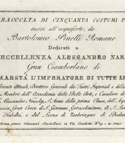
Pinelli Bartolomeo, New collection of fifty picturesque costumes, 1817
950,00 €New Collection of Fifty Picturesque Costumes It is a work created by Bartholomew Pinelli in 1817.
This collection, dedicated to His Excellency Alexander Narischkin, Grand Chamberlain of His Majesty the Emperor of all the Russias, is composed of 50 etching plates, numbered from 1 to 50.
- Volume dimensions: mm 168×227
- Support: Rustic cardboard
- Condition: Good copy with slight marginal foxing
The work is published in Rome by Giovanni Scudellari in Via Condotti N. 19 and 20.
Pinelli Bartolomeo, Collection of the costumes of Rome, 1819
1.800,00 €Collection of Roman costumes It is a work created by Bartholomew Pinelli In the 1819.
This collection, published in Rome by Scudellari, includes 50 etchings, all watercolours and signed by the author. The engravings represent professions, costumes and scenes of life of the inhabitants of Rome and its surroundings, offering a fascinating look at the culture of the time.
- Sheet size: cm. 27×42 approx.
- Support: Paper
- Condition: Good
- Binding: Hardback with leather spine (minor defects)

Pinelli, Ballo di Sposi Ciociari, 1820
40,00 €Ballo di Sposi Ciociari it is an engraving made by Bartolomeo Pinelli in 1820.
This work is taken from the Collection of various compositions and some motifs, Picturesque Costumes of Rome and its surroundings, published by Tommaso Cuccioni in Rome.
- Sheet size: cm. 19×25 approx.
- Engraving size: cm. 10×14 approx.
- Technique: Etching, colored with watercolor
- Condition: Excellent, with slight spots of color on the back
