
Shop
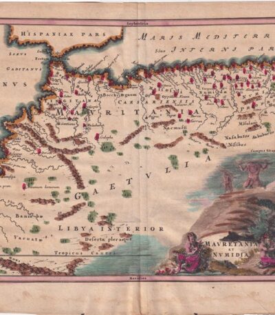
1701, Mauritania and Numidia, from Cellario
60,00 €1701, Mauretania and Numidia it is a copper-engraved and water-coloured map, taken from the volume Notitia Orbis Antiqui sive Geographia Plenior by Christophorus Cellarius, published in 1701.
This hand-colored engraving has dimensions of cm. 20×30 for engraving and cm. 24×33 for the sheet.
- Sheet size: cm. 24×33 approx.
- Engraving size: cm. 20×30 approx.
- Support: Paper
- Condition: Good condition, with some stains on the edges
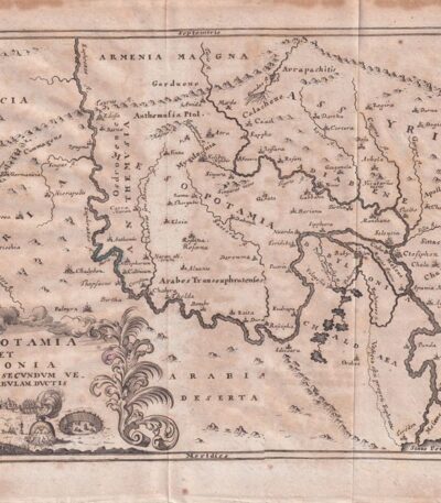
1701, Mesopotamia by Cellario
60,00 €1701, Mesopotamia è una mappa incisa su rame, realizzata da Christophorus Cellarius nel 1701.
This engraving is taken from the volume Notitia Orbis Antiqui sive Geographia Plenior.
- Engraving size: cm. 20×30 approx.
- Sheet size: cm. 24×33 approx.
- Support: Paper
- Condition: Good, with some stains on the edges and editorial creases

1701, Mesopotamia, from Cellario
60,00 €1701, Mesopotamia è una mappa incisa su rame e acquarellata, proveniente dall’opera Notitia Orbis Antiqui sive Geographia Plenior by Christophorus Cellarius, published in 1701.
Questa incisione rappresenta un’importante testimonianza geografica delle antiche civiltà mesopotamiche e babilonesi.
- Sheet size: cm. 24×33 approx.
- Engraving size: cm. 20×30 approx.
- Support: Paper
- Condition: Good, with some stains on the edges
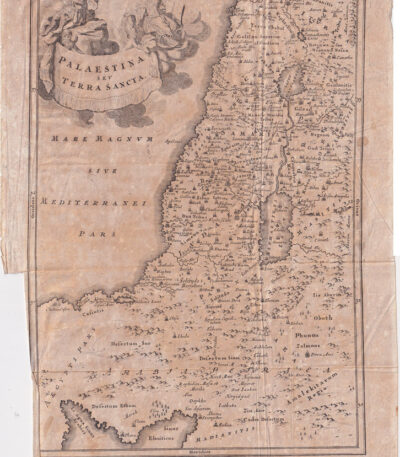
1701, Palestine, from the Cellarium
60,00 €Palestina e Terra Santa It is a copper engraving made in 1701, taken from the volume Notitia Orbis Antiqui sive Geographia Plenior by Christophorus Cellarius.
Questa opera offre una rappresentazione dettagliata della regione, evidenziando la sua importanza storica e geografica.
- Sheet size: cm. 24×38 approx.
- Engraving size: cm. 20×35 approx.
- Support: Paper
- Condition: Good, with some stains on the edges and editorial creases
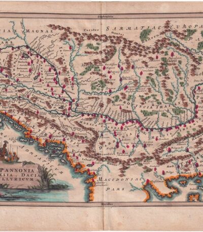
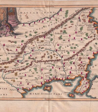
1701, Pannonia, from the Cellarium
60,00 €1701, Pannonia è una mappa storica che rappresenta le regioni di Pannonia, Moesia e Dacia, realizzata da Christophorus Cellarius nel 1701.
Questa incisione su rame è stata colorata a mano e fa parte dell’opera Notitia Orbis Antiqui sive Geographia Plenior.
- Sheet size: cm. 24×33 approx.
- Engraving size: cm. 20×30 approx.
- Support: Paper
- Condition: Good, with some stains on the edges
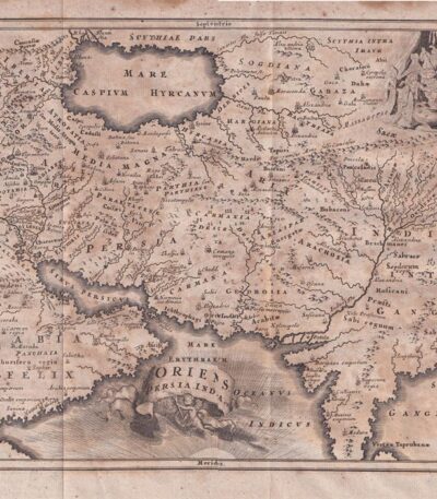
1701, Persia, from Cellario Cellarius
60,00 €1701, Persia è un’incisione su rame tratta dal Notitia Orbis Antiqui sive Geographia Plenior by Christophorus Cellarius, published in 1701.
Questa opera rappresenta una mappa dettagliata della Persia e dell’India, evidenziando le caratteristiche geografiche dell’epoca.
- Sheet size: cm. 24×38 approx.
- Engraving size: cm. 20×35 approx.
- Support: Paper
- Condition: Buone condizioni, con qualche macchia ai margini e pieghe editoriali

1701, Scythia and Serica
60,00 €1701, Scythia and Serica It is a copper engraving made by Christophorus Cellarius, taken from the work Notitia Orbis Antiqui sive Geographia Plenior, pubblicata nel 1701.
Questa incisione offre una rappresentazione dettagliata delle regioni storiche della Scizia e della Serica, evidenziando l’importanza geografica di queste aree nel contesto antico.
- Sheet size: cm. 24×38 approx.
- Engraving size: cm. 20×35 approx.
- Support: Paper
- Condition: Good, with some stains on the edges and editorial creases
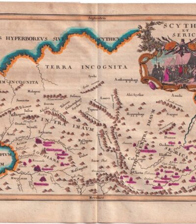
1701, Scythia and Serica, from Cellario
60,00 €Scythia and Serica It is a copper-engraved and watercoloured map, created in 1701 by Christophorus Cellarius.
This piece is taken from Notitia Orbis Antiqui sive Geographia Plenior, a work that offers a detailed vision of ancient geographies.
- Sheet size: cm. 24×33 approx.
- Engraving size: cm. 20×30 approx.
- Support: Paper
- Condition: Good, with some stains on the edges
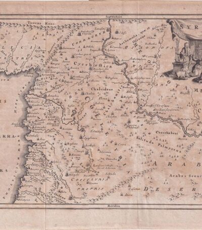
1701, Syria from Cellarius
60,00 €1701, Syria from Cellarius è una mappa incisione su rame che rappresenta la Siria, la Mesopotamia e l’Arabia.
This work is taken from Notitia Orbis Antiqui sive Geographia Plenior by Christophorus Cellarius, published in 1701.
- Sheet size: cm. 24×33 approx.
- Engraving size: cm. 20×30 approx.
- Support: Paper
- Condition: Good, with some stains on the edges and editorial creases
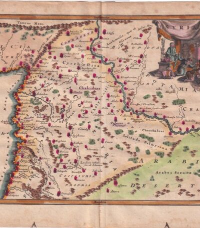
1701, Syria, Map, from the Cellarium
60,00 €Mappa della Siria è un’incisione su rame acquarellata, realizzata nel 1701, tratta da Notitia Orbis Antiqui sive Geographia Plenior by Christophorus Cellarius.
Questa mappa, colorata a mano, presenta dimensioni di cm. 20×30 for engraving and cm. 24×33 for the sheet.
- Sheet size: cm. 24×33 approx.
- Engraving size: cm. 20×30 approx.
- Support: Paper
- Condition: Good, with some stains on the edges
1701, Thrace, Map, from Cellarium
60,00 €Mappa della Tracia è un’incisione su rame acquarellata, realizzata nel 1701 da Christophorus Cellarius.
This piece is taken from Notitia Orbis Antiqui sive Geographia Plenior, a fundamental work for ancient geography.
- Sheet size: cm. 24×33 approx.
- Engraving size: cm. 20×30 approx.
- Support: Paper
- Condition: Buone condizioni con qualche macchia ai margini
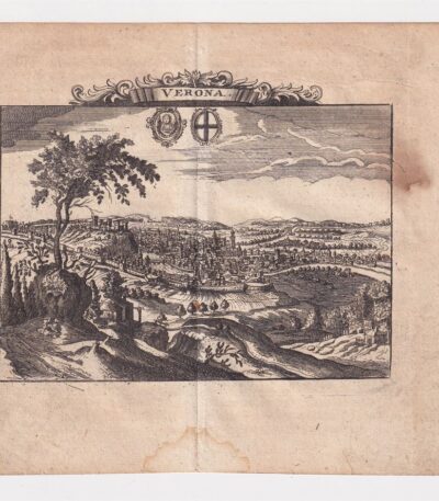
1712, Ancient map of Verona
50,00 €Ancient map of Verona from 1712 is a copper engraving that represents one of the most fascinating historical maps of the city.
This map is taken from the volume The Delights of Italy by De Rogissart and presents accurate details of the Veronese topography of the time.
- Sheet size: cm. 16×17 approx.
- Engraving size: cm. 11×14 approx.
- Support: Light laid paper
- Condition: Excellent state of preservation
- Rarity: Rare
1718, Southern Italy, C.Weigel
220,00 €1718, Southern Italy it's a lithography with contemporary watercolour, made by C. Weigel.
This map represents ancient Italy from Octavian Augustus in Regions XI described.
- Place of publication: Nuremberg
- Year of publication: 1718
- Sheet size: cm. 39×47
- Condition: Excellent, with editorial center fold
- Rarity: Rare representation, with excellent colouring
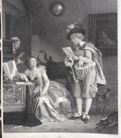
1785-1794 Gerard The Art of Love Courtship Etching Dotted
180,00 €The Art of Loving: Courtship It is an engraving made between the 1785 and 1794 from Mr. Gerard, an artist known for his refined and elegant style. The print, created with the etching and dotting technique, captures a delicate moment of courtship, reflecting the aesthetic and decorative taste typical of the 18th century. At the bottom, the signatures "M. Gerard pinxit" and "Ferard Sculpsit" are visible, testifying to the authenticity of the work.
This print stands out for its artistic beauty and strong decorative impact, ideal for enthusiasts of vintage engravings.
- Era: 18th century
- Technique: Etching and dotting
- Dimensions: Large (about 56×45 cm)
- Support: Medium thickness paper, white back
- Condition: Excellent condition
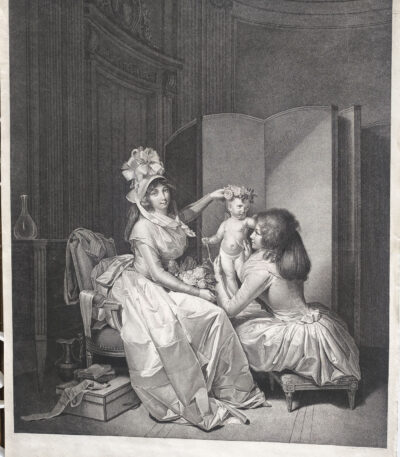
1793 Boilly l'amour couronne dotted engraved by Cazenave
250,00 €The Love of the Crown It is a dotted etching made by the engraver Jean-François Cazenave In the 1793, inspired by a painting by the famous French artist Louis-Léopold Boilly.
This work is an exceptional example of the stippling technique, particularly in vogue in France and England at the end of the 18th century, made famous by masters such as Francesco Bartolozzi. Cazenave, born in Paris around 1770, distinguished himself as a specialist in this technique, collaborating with renowned artists such as Boilly and Prud'hon.
- Era: 18th century
- Technique: Etching and dotting
- Dimensions: Large (approx. 56 x 45 cm)
- Support: Thick paper with white backing
- Condition: Excellent state of preservation
This print is characterized by a high artistic and decorative quality, making it an ideal choice for collectors and lovers of historical art.

1793 Boilly the dotted Zograscope L'Optique engraved by Cazenave
250,00 €The Optique it is a dotted etching made by Jean-François Cazenave In the 1793, inspired by a painting by Louis-Léopold Boilly.
The work portrays Louise-Sebastienne Gély, second wife of Georges Danton, and Antoine, son of Danton's first marriage, observing prints through a Zograscope, an optical instrument popular in the 18th century.
This print is an excellent example of the fashion for stipple engraving, introduced in France in the late eighteenth century, partly inspired by the work of Francesco Bartolozzi in England.
- Era: 18th century
- Technique: Dotted etching
- Dimensions: Large (about 56×45 cm)
- Support: Thick paper with white backing
- Condition: Excellent state of preservation
The Optique It is a work of great decorative and artistic impact, appreciated not only for its technical refinement but also for its historical value, linked to the French Revolutionary period. Jean-François Cazenave, born in Paris around 1770, was a master of stipple engraving, and this print is considered one of the masterpieces of his production.

1793 Pierre-Paul Prud'hon Children with a Rabbit, etching and dotting
250,00 €Children with rabbit it is a dotted etching made by the engraver B. Roger in 1793, inspired by a painting by Pierre-Paul Prud'hon, a famous French Romantic painter. Prud'hon, active between the 18th and 19th centuries, was famous for his allegorical paintings and portraits that combined grace and romantic sensitivity. This work represents a delicate moment of childhood intimacy, captured with exceptional technical finesse and a decorative touch.
- Era: 18th century
- Technique: Dotted etching
- Dimensions: Large (approximately 56×45 cm)
- Support: Thick paper with white backing
- Condition: Excellent
This print stands out for its visual and decorative impact, ideal for enriching artistic collections or refined environments.
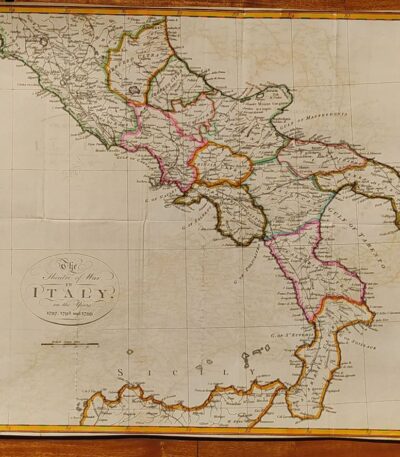
1800, Map of Southern Italy
120,00 €1800, Map of Southern Italy It is a hand-colored lithograph representing The Theater of War in Italy in the years 1797, 1798 and 1799.
This map offers a rare and detailed view of the conflict, with exceptional colouring that enhances the details.
- Sheet size: cm. 38×45
- Condition: Excellent condition
- Technique: Lithography
- Support: Paper

1800, Map of Southern Italy
80,00 €1800, Map of Southern Italy it is a lithograph that represents The Theatre of War in Italy in the years 1797, 1798 and 1799.
This map offers a rare and detailed view of the war context of the time, making it a piece of great historical interest.
- Sheet size: cm. 38×45 approx.
- Technique: Lithography
- Condition: Excellent condition
- Support: Paper

1800, Map of Northern Italy
120,00 €Map of Northern Italy It is a lithograph made in 1800, representing the theatre of war in Italy during the campaigns of 1796 and 1799.
This hand-colored map is a rare historical representation with exceptional coloring.
- Sheet size: cm. 41×65
- Condition: Excellent, with some editorial creases
- Technique: Lithography
- Support: Paper

1800, Map of Northern Italy
80,00 €1800, Map of Northern Italy It is a lithograph representing a detailed map of the theatre of war in Italy during the campaigns of 1796 and 1799.
This rare representation offers a fascinating glimpse into the historical events of that period.
- Sheet size: cm. 41×65
- Condition: Excellent, with some editorial creases
- Support: Paper

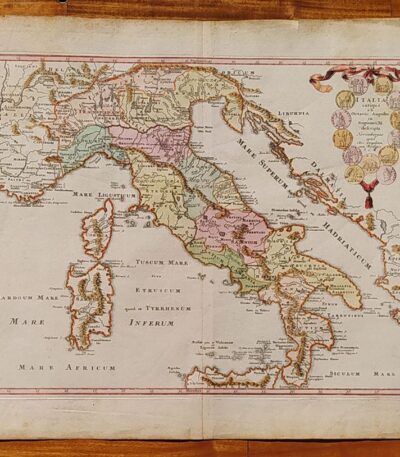
1838 Map of Italy and Sicily watercolored by Delamarche
80,00 €Map of Italy and Sicily, by Delamarche, 1838. On unlaid paper of medium thickness, cm.34×48, white back. Colored with watercolours at a later date. Excellent condition.
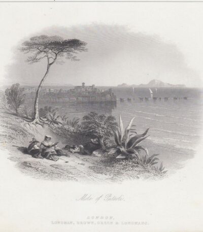
1840, The pier of Pozzuoli
30,00 €The pier of Pozzuoli It is an etching made in 1840, which captures a lively pier scene with figures in the foreground.
In the background you can admire the Terra di Pozzuoli district and, in the distance, the island of Capri.
- Sheet size: cm. 17×21
- Support: Thick paper with white backing
- Condition: Excellent condition
- Engraver: London, Brown, Green and Longmans
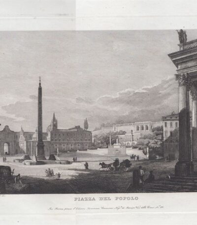
1843, Rome, People's Square, Cottafavi
70,00 €People's Square It is an engraving made by Gaetano Cottafavi In the 1843, part of the Collection of the Principal Views of Rome and its Surroundings.
This work represents a lively and decorative view of the famous Roman square, characterized by an excellent contrast and printed on heavy paper.
- Engraving size: cm. 17×24 approx.
- Copper strike dimensions: cm. 21×26 approx.
- Sheet size: cm. 32×47 approx.
- Support: Heavy paper
- Condition: Excellent condition
This engraving will be shipped in a hard tube for maximum protection.
