
Shop
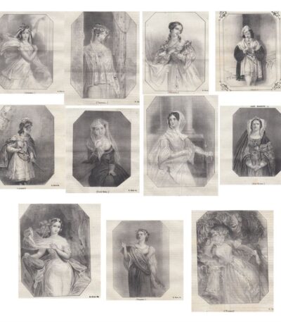
1844 Shakespeare's Women Gallery
70,00 €Shakespeare's Women Gallery It is an extraordinary collection of lithographs made in 1844, which celebrates the female figures in Shakespeare's works.
This series includes iconic characters such as Miranda, Juliet, Lady Macbeth and Titania, portrayed with great mastery. The emotions and virtues of Shakespearean women emerge vividly through their expressions, reflecting the passions and ideals of the comedies and tragedies of the famous playwright.
- Number of lithographs: 11
- Dimensions of each lithograph: cm. 10 x 14 approx.
- Sheet size: cm. 29 x 20 approx.
- Technique: Lithography
- Support: Paper
- Condition: Excellent
The pages will be shipped whole, containing the prints with writing on the front and back.
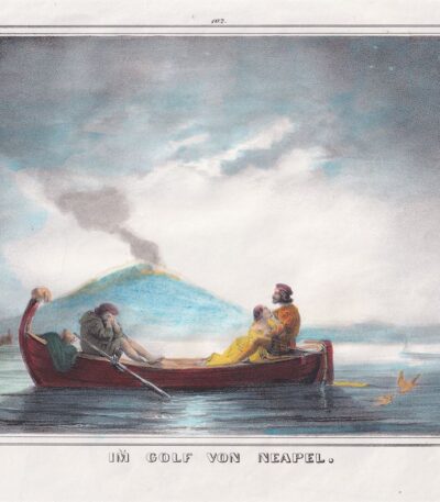
1850, In the Gulf of Naples, Watercolor lithograph
35,00 €Nel Golfo di Napoli è una litografia acquarellata realizzata nel 1850, che cattura la bellezza del paesaggio napoletano.
This work, entitled Im Golf von Neapel, presenta dettagli vividi e colori delicati che evocano l’atmosfera di questo famoso golfo.
- Sheet size: cm. 21×26 approx.
- Dimensions of the work: cm. 16×22 approx.
- Support: Paper
- Condition: Excellent condition
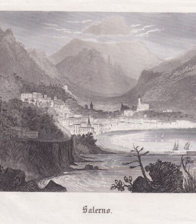
1850, Salerno, etching
30,00 €Salerno It is an engraving made in 1850, executed with the technique ofetching.
This work, of small dimensions, measures 10x14 cm and has small margins.
- Sheet size: cm. 10×14 approx.
- Condition: Excellent state of preservation
- Support: Light paper
The back is blank, making the work ideal for collectors and engraving enthusiasts.
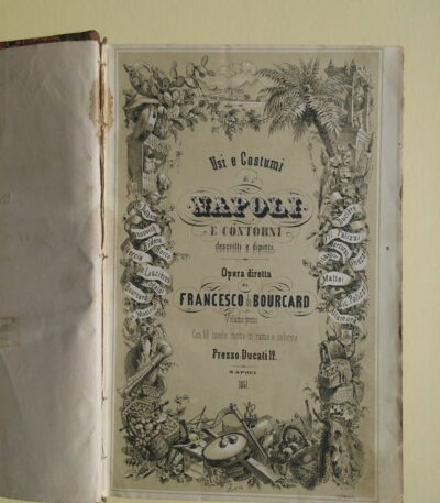
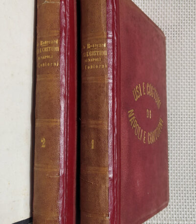
1853-58 De Bourcard Francesco Customs and Traditions of Naples
4.200,00 €Customs and Traditions of Naples It is a work directed by Francis De Bourcard, published in Naples between 1853 and 1858.
This extraordinary collection is composed of two volumes in 4° format (mm. 254×162) and includes 100 vintage colored plates, beautifully illustrated with etchings.
- Illustrations: It depicts popular customs, habits and scenes of the 19th century in the Kingdom of Naples and the Two Sicilies.
- Artists: Engravings by Duclère, Pisante, Mattei, Fusaro, Cucinotta, De Bartolo and Filippo Palizzi.
- Lyrics: Written by authors such as Cozzovick, Rocco, Coppola, Mastriani, Dalbono, Orgitano and De Bourcard.
The work is considered rare, especially if complete with all its plates.
- Condition: Good example with some foxing and reinforcements on the spine.
- Weight: kg. 2.5.
1853-58, De Bourcard Francesco, Customs and Traditions of Naples
4.000,00 €Customs and Traditions of Naples It is a work directed by Francis De Bourcard, published in Naples between 1853 and 1858.
This work is composed of two volumes in 4° format (mm. 254×162) and includes an extraordinary collection of 100 vintage colored plates, etched and hand-coloured, which represent typical customs and traditions of Naples and the Kingdom of the Two Sicilies in the nineteenth century.
- Authors of the engravings: Duclère, Pisante, Mattei, Fusaro, Cucinotta, De Bartolo and Filippo Palizzi
- Lyrics by: Cozzovick, Rocco, Coppola, Mastriani, Dalbono, Orgitano, De Bourcard
- Condition: Excellent, fresh interior without blooms
- Rarity: Complete with all 100 tables
- Weight: kg. 2.5
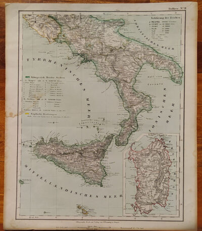
1855, Map of Southern Italy
80,00 €1855, Map of Southern Italy It is a lithograph made by C. Flemming, published in 1855.
This map represents Southern Italy and Sardinia, and was produced by Berghaus, Heinrich and Sohr, Karl.
- Sheet size: cm. 44×37
- Coloration: Contemporary with the outline
- Condition: Excellent condition
- Rarity: Rare representation with excellent coloring
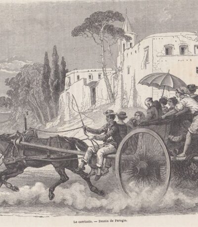
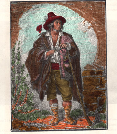
1860 The Dessin de Ferogio corridor. The Corricolo.
25,00 €The Corricolo It is a woodcut from 1860, taken from The World Tour.
This work depicts a public cart on the move, with Vesuvius in the background and a variety of people on board, while a beggar is left on the ground.
- Sheet size: cm. 29×21 approx.
- Engraving size: cm. 24×17 approx.
- Support: Paper
- Condition: Excellent
1860, Colored map of Central and Southern Italy
80,00 €1860, Colored map of Central and Southern Italy is a steel engraving published in 1860 by Blackie & Son, London, for The Imperial Atlas of Modern Geography by Walter Graham Blackie.
This map has been hand colored with watercolor and features a central editorial fold.
- Sheet size: cm. 54×37
- Support: Strong paper
- Condition: Excellent condition
The back is white.

1861, Map of Southern Italy
60,00 €1861, Map of Southern Italy It is a historical map representing the regions of Southern Italy, including Sicily, Sardinia and Corsica.
This card was made by Reichard and is part of the volume Ancient Earth Orb, published circa 1861.
- Sheet size: cm. 33×39
- Coloration: Manual
- Condition: Excellent condition
- Rarity: Rare representation with excellent coloring

1870 Facsimile of autograph by Gioberti, Pellico and Ristori
25,00 €Facsimile of autographs by Gioberti, Pellico and Ristori it is a woodcut representing an autograph letter of Vincenzo Gioberti And Silvio Pellico, with a letter from Adelaide Ristori on the back.
This sheet was extracted from thePicturesque Emporium of 1870, an important publication of the time.
- Sheet size: cm. 29×20
- Technique: Woodcut
- Condition: Excellent
- Support: Paper

1870 Facsimile of Goethe's autograph
20,00 €Facsimile of Goethe's autograph it is a woodcut reproducing an autographed letter by the famous German writer Johann Wolfgang von Goethe.
This sheet was extracted from thePicturesque Emporium of 1870, an important publication of the time.
- Sheet size: cm. 29×20
- Support: Paper
- Condition: Excellent
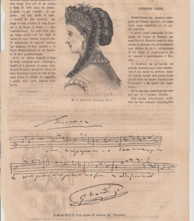
1870 Facsimile of a piece from Il Trovatore
25,00 €Facsimile of a piece from Il Trovatore it is a woodcut made in 1870, which presents a passage from the work The Troubadour.
On the back of the sheet there is a facsimile of the signature of John Calvin and of Saint Charles Borromeo.
This sheet was extracted from thePicturesque Emporium of 1870.
- Sheet size: cm. 29×20
- Technique: Woodcut
- Condition: Excellent
- Support: Paper
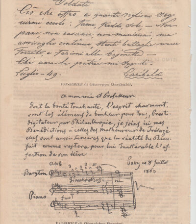
1870 Facsimile of a letter from Garibaldi and Rossini
25,00 €Facsimile of a letter from Garibaldi and Rossini It is an engraving made in 1870, which features an autograph of two famous Italian figures: Giuseppe Garibaldi and Gioacchino Rossini.
This sheet was extracted from thePicturesque Emporium and represents an important historical testimony.
- Sheet size: cm. 29×20
- Technique: Woodcut
- Condition: Excellent
- Support: Paper
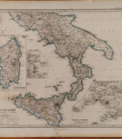
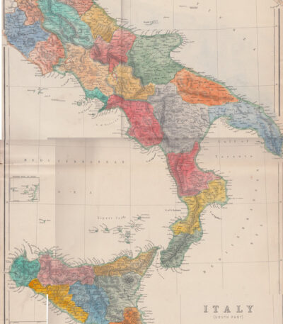
1874, Map of Southern Italy
80,00 €1874, Map of Southern Italy It is a copper engraving made by Jungmann for Stieler, published in Gotha by Justus Perthes in 1874.
This detailed map shows the regions of Naples, Sardinia, Palermo and the Strait of Messina, and is part of the work Hand Atlas by A. Stieler.
- Sheet size: cm. 38×46 approx.
- Engraving size: cm. 33×40 approx.
- Support: Paper
- Condition: Good condition, with a light damp stain in the lower corner
The map features contemporary contour colouring, which enhances its historical and artistic value.
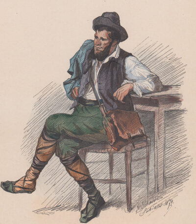
1874, Ciociaro peasant
30,00 €Ciociaro Farmer it is a watercolour lithograph made in 1874 by A. Schmid, depicting a peasant from the Ciociaria region.
This work is characterized by a sheet size of cm. 23×18, printed on thick paper with white back.
- Sheet size: cm. 23×18 approx.
- Support: Thick paper
- Condition: Excellent condition
1877 Pecoraio xilografia acquarellata
35,00 €Pecoraio
- Technique: Woodcut
- Era: 1877
- Origine: Tratta da un testo francese
- Dimensions:
- Immagine: cm 18×14
- Foglio: cm 22×18
- Characteristics:
- Retro stampato
- Light paper
- Acquarellata in epoca successiva
Description:
Questa delicata xilografia raffigura un shepherd, probabilmente colto in un momento di vita quotidiana, intento alla cura del gregge o in una scena bucolica. L’opera proviene da un testo francese e presenta un’acquarellatura eseguita in epoca successiva, che ne esalta i dettagli e ne arricchisce la componente pittorica.
La presenza della stampa sul retro indica che l’immagine faceva parte di un’opera più ampia, forse un libro illustrato o una raccolta iconografica. Il tratto incisivo della xilografia, unito alla colorazione successiva, dona alla scena un fascino senza tempo, evocando atmosfere rurali e pastorali tipiche della tradizione iconografica europea.

1880 Capri staircase watercolor woodcut
35,00 €Woodcut from a French text. Image size approx. 20x13 cm; almost no margins. The print was extracted from the book and has a printed back; light sheet. Water-coloured at a later date.

1880 Capri watercolor woodcut
30,00 €Woodcut from a German text from 1880. Image size approx. 12x12 cm; almost no margins. The print was extracted from the book and has a printed back; light sheet. Water-coloured at a later date.
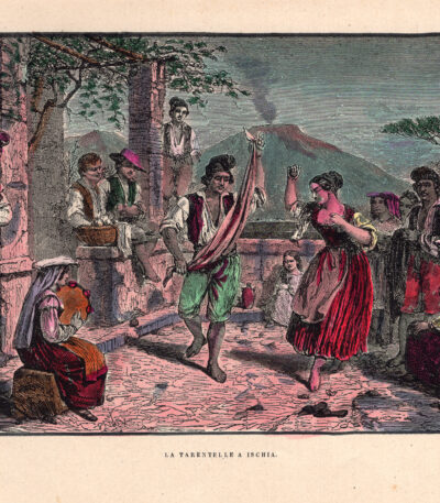
1880 The Tarantella in Ischia watercolor woodcut
35,00 €The Tarantella in Ischia. Woodcut from a French text. Image size approx. 12x18 cm on 16x25 cm sheet. The print has a white back; light sheet. Water-coloured at a later date.

1880 Naples Vesuvius panorama watercolor woodcut
35,00 €Naples panorama with smoking Vesuvius. Woodcut from a French text. Image size approx. 12x18 cm on 16x25 cm sheet. The print has a white back; light sheet. Water-coloured at a later date.

1880 Naples Vesuvius watercolor woodcut
30,00 €Naples panorama with smoking Vesuvius. Woodcut from a German text. Image size approx. 12x12 cm; almost no margins. The print was extracted from the book and has a printed back; light sheet. Water-coloured at a later date.
1880, Isola Bella, Lake Maggiore
20,00 €Beautiful Island, Lake Maggiore It is an engraving made in 1880, which captures the beauty of one of the most evocative places in Italy.
This work is taken from the volume Picturesque Europe and features refined details that pay homage to the lake landscape.
- Sheet size: mm. 160×230 approx.
- Support: Light paper
- Condition: Excellent
- Back: Printed

1884 Amalfi watercolor woodcut
45,00 €Amalfi, Das Kapuzinerkloster bei Amalfi – 1884
Woodcut engraving with hand-coloured watercolour, from the work Neapel und seine Umgebung by Rudolf Kleinpaul, published in Leipzig in 1884.
Questa suggestiva veduta raffigura il monastero dei Cappuccini ad Amalfi, resa ancora più affascinante dall’acquarellatura esperta che ne esalta i dettagli e la vivacità dei colori. La stampa è eseguita su carta leggera con retro bianco, in ottime condizioni di conservazione.
- Era: 19th century (1884)
- Technique: Hand-watercoloured woodcut engraving
- Dimensions: Engraving: 24×16 cm; whole sheet: 36×27 cm
- Support: Light paper
- Condition: Excellent
Un’opera interessante e decorativa, ideale per collezionisti di stampe antiche e appassionati di vedute italiane storiche.

1884 Amalfi watercolour woodcut round format
35,00 €Amalfi – 1884
Woodcut engraving with hand-coloured watercolour, from the work Neapel und seine Umgebung by Rudolf Kleinpaul, published in Leipzig in 1884.
The scene depicts a suggestive glimpse of the Amalfi coast, enhanced by expert watercolouring that gives depth and vivacity to the image. A work of great decorative and historical interest, printed on light paper with an embossed back.
- Era: 19th century (1884)
- Technique: Hand-watercoloured woodcut engraving
- Dimensions: Engraving: 15.5×15.5 cm; whole sheet: 17×20 cm
- Support: Lightweight paper with printed back
- Condition: Excellent
A decorative and valuable view, ideal for collectors of antique prints and lovers of historical representations of the Amalfi coast.
