
Small

Philippus Cluverius (1580-1622), England, 1686
80,00 €Philippus Cluverius (1580-1622) presents a map of England, part of the British Isles, dated 1686.
This copper engraving is watercolour and comes from the work Introductionis in universam geographiam, tam veterem quam novam, libri VI, published in Amsterdam in 1686.
- Sheet size: mm. 134×140
- Technique: Burin
- Support: Laid paper
- Condition: Excellent

Philippus Cluverius (1580-1622), Liguria, 1686
80,00 €Philippus Cluverius è un’incisione in rame acquarellata realizzata nel 1686, rappresentante la Liguria, Italia Settentrionale.
This work is taken from the volume Introductionis in universam geographiam, tam veterem quam novam, libri VI, published in Amsterdam.
- Sheet size: mm. 134×140
- Support: Laid paper with partial watermark
- Condition: Excellent condition

Philippus Cluverius (1580-1622), Map of Europe, 1686
80,00 €Philippus Cluverius – Map of Europe It is a watercolour copper engraving made in 1686.
This map is taken from the work Introductionis in universam geographiam, tam veterem quam novam, libri VI, published in Amsterdam.
- Sheet size: mm. 134×140
- Technique: Burin
- Support: Laid paper
- Condition: Excellent condition
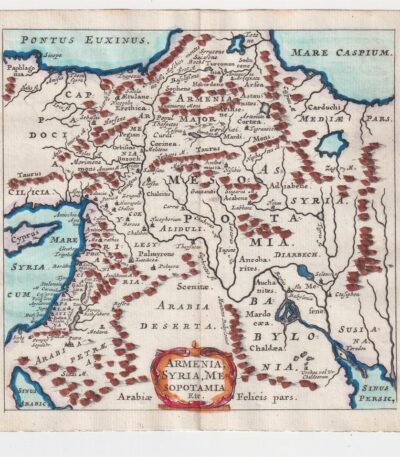
Philippus Cluverius (1580-1622), Mappa della Armenia 1686
60,00 €La Mappa della Armenia It is an engraving made by Philippus Cluverius nel 1686, che rappresenta non solo l’Armenia, ma anche la Siria e la Mesopotamia.
This map is taken from the work Introductionis in universam geographiam, tam veterem quam novam, libri VI, published in Amsterdam.
- Sheet size: mm. 134×140
- Technique: Incisione in rame acquarellata
- Support: Laid paper
- Condition: Excellent condition

Philippus Cluverius (1580-1622), Map of China, 1686
70,00 €Philippus Cluverius (1580-1622) presents a map of China and Japan, built in 1686.
This copper engraving is watercolour and comes from the work Introductionis in universam geographiam, tam veterem quam novam, libri VI, published in Amsterdam.
- Sheet size: mm. 134×140
- Technique: Burin
- Support: Laid paper
- Condition: Excellent
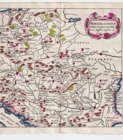
Philippus Cluverius (1580-1622), Map of Dacia, 1686
60,00 €Philippus Cluverius – Map of Dacia It is a watercolour copper engraving made in 1686.
This map represents Dacia, Hungary, Poland and Moesia, and is taken from the work Introductionis in universam geographiam, tam veterem quam novam, libri VI, published in Amsterdam.
- Sheet size: mm. 134×140
- Technique: Burin
- Support: Laid paper
- Condition: Excellent

Philippus Cluverius (1580-1622), Mappa della Francia, 1686
80,00 €La Mappa della Francia It is an engraving made by Philippus Cluverius nel 1686.
This map, part of the work Introductionis in universam geographiam, tam veterem quam novam, è un esempio significativo della cartografia del XVII secolo.
- Sheet size: cm. 13.4×14 approx.
- Engraving size: cm. 13.4×14 approx.
- Support: Laid paper
- Condition: Excellent state of preservation

Philippus Cluverius (1580-1622), Mappa della Germania 1686
60,00 €Philippus Cluverius (1580-1622) presents a Mappa della Germania Inferiore, built in 1686.
This copper engraving is watercolour and comes from the work Introductionis in universam geographiam, tam veterem quam novam, libri VI, published in Amsterdam in 1686.
- Sheet size: mm. 134×140
- Technique: Burin
- Support: Laid paper
- Condition: Excellent

Philippus Cluverius (1580-1622), Mappa della Germania, 1686
60,00 €Philippus Cluverius – Mappa della Germania It is a watercolour copper engraving made in 1686.
This map is taken from the work Introductionis in universam geographiam, tam veterem quam novam, libri VI, published in Amsterdam.
- Sheet size: mm. 134×140
- Support: Laid paper
- Condition: Excellent condition

Philippus Cluverius (1580-1622), Mappa della Germania, 1686
60,00 €Philippus Cluverius (1580-1622) presents a Map of Germany realizzata nel 1686.
Questa incisione in rame è stata acquarellata e proviene dall’opera Introductionis in universam geographiam, tam veterem quam novam, libri VI, published in Amsterdam.
- Sheet size: mm. 134×140
- Technique: Burin
- Support: Laid paper
- Condition: Excellent
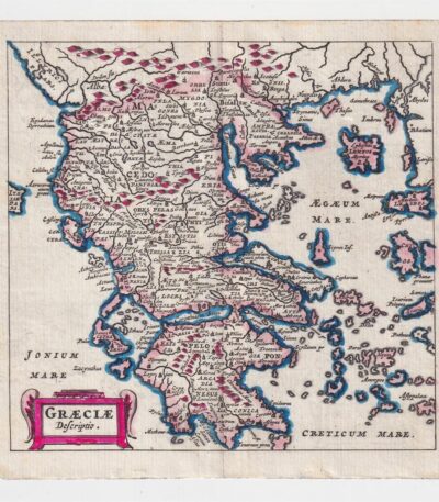
Philippus Cluverius (1580-1622), Map of Greece, 1686
60,00 €Philippus Cluverius – Map of Greece It is a watercolour copper engraving made in 1686.
This map is taken from the work Introductionis in universam geographiam, tam veterem quam novam, libri VI, published in Amsterdam.
- Sheet size: cm. 13.4×14 approx.
- Support: Laid paper
- Condition: Excellent state of preservation
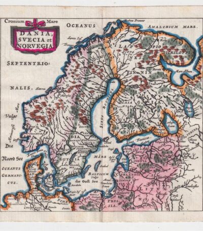
Philippus Cluverius (1580-1622), Mappa della Norvegia, 1686
80,00 €La Mappa della Norvegia di Philippus Cluverius è un’incisione in rame acquarellata realizzata nel 1686.
Questa mappa, che include anche la Svezia e la Danimarca, è tratta dall’opera Introductionis in universam geographiam, tam veterem quam novam, libri VI, published in Amsterdam.
- Sheet size: mm. 134×140
- Support: Laid paper
- Condition: Excellent condition
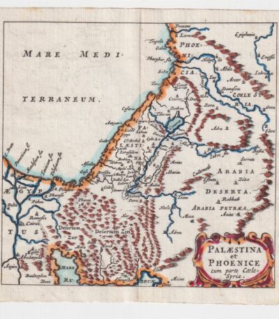
Philippus Cluverius (1580-1622), Map of Palestine, 1686
60,00 €The Map of Palestine It is an engraving made by Philippus Cluverius (1580-1622) in 1686.
This map, representing Palestine and Syria, is taken from the work Introductionis in universam geographiam, tam veterem quam novam, libri VI, published in Amsterdam.
- Sheet size: mm. 134×140
- Technique: Burin
- Support: Laid paper
- Condition: Excellent condition
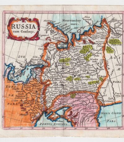
Philippus Cluverius (1580-1622), Mappa della Russia, 1686
60,00 €La Mappa della Russia It is an engraving made by Philippus Cluverius (1580-1622) in 1686.
This map is taken from the work Introductionis in universam geographiam, tam veterem quam novam, libri VI, published in Amsterdam.
- Sheet size: mm. 134×140
- Technique: Incisione in rame acquarellata
- Support: Laid paper
- Condition: Excellent condition

Philippus Cluverius (1580-1622), Map of Spain, 1686
80,00 €Philippus Cluverius – Mappa della Spagna It is a watercolour copper engraving made in 1686.
This map is taken from the work Introductionis in universam geographiam, tam veterem quam novam, libri VI, published in Amsterdam.
- Sheet size: mm. 134×140
- Technique: Burin
- Support: Laid paper
- Condition: Excellent condition
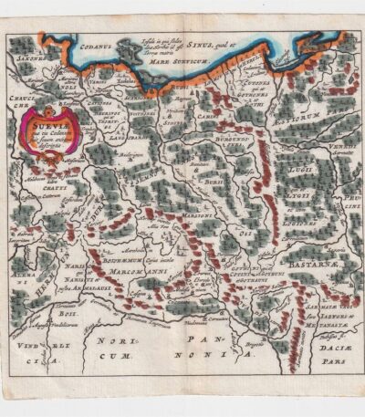
Philippus Cluverius (1580-1622), Mappa della Suevia, 1686
60,00 €Philippus Cluverius (1580-1622) presenta la sua Mappa della Suevia, un’incisione in rame acquarellata realizzata nel 1686.
Questa mappa, che rappresenta la regione della Suevia in Germania, è tratta dall’opera Introductionis in universam geographiam, tam veterem quam novam, libri VI, published in Amsterdam.
- Sheet size: mm. 134×140
- Technique: Burin
- Support: Laid paper
- Condition: Excellent
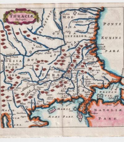
Philippus Cluverius (1580-1622), Mappa della Tracia, 1686
60,00 €La Mappa della Tracia è un’incisione realizzata da Philippus Cluverius nel 1686, che rappresenta la Tracia, la Dacia e la Bulgaria.
This map is taken from the work Introductionis in universam geographiam, tam veterem quam novam, libri VI, published in Amsterdam.
- Sheet size: mm. 134×140
- Technique: Burin
- Support: Laid paper
- Condition: Excellent
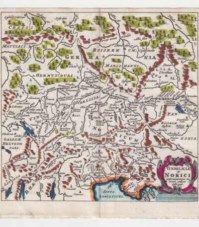
Philippus Cluverius (1580-1622), Mappa della Vindelicia, 1686
60,00 €La Mappa della Vindelicia It is an engraving made by Philippus Cluverius (1580-1622) in 1686.
Questa mappa rappresenta la regione della Vindelicia, situata in Germania, ed è parte dell’opera Introductionis in universam geographiam, tam veterem quam novam, libri VI, published in Amsterdam.
- Sheet size: mm. 134×140
- Technique: Burin
- Support: Laid paper
- Condition: Excellent condition

Piacenza, 1834
35,00 €Piacenza, 1834 è un’incisione al bulino che offre una vista panoramica della città di Piacenza, realizzata nel 1834.
This work is taken from the volume Italy picturesque tableau historique and description of Italy… by M. De Norvins and C. Nodiers.
- Sheet size: mm. 185×120 approx.
- Support: Light paper
- Condition: Good condition
La stampa presenta margini e un retro bianco, rendendola una bella veduta decorativa e panoramica.
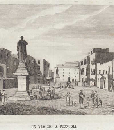
Piazza di Pozzuoli, 1839
20,00 €Piazza di Pozzuoli, 1839 è un’incisione in rame realizzata da Segoni, che offre una bella veduta decorativa della piazza.
This work is taken from Picturesque Omnibus, un’enciclopedia artistica e letteraria con figure incise in rame, diretta da Vincenzo Torelli e pubblicata a Napoli dalla tipografia dell’Omnibus nel 1839.
- Printed part dimensions: cm. 16×11 approx.
- Condition: Excellent
- Support: Paper
- Notes: The print has been cut from the book and has writing on the back; it is shipped complete with mat.

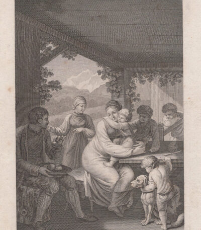
Small engraving from the 18th-19th century
20,00 €Small engraving from the 18th-19th century it is a work of approximately 7x10 cm, made on the copper plate with reduced margins.
This engraving depicts a life scene with perfectly delineated characters, comparable to excellent miniatures.
- Sheet size: cm. 7×10 approx.
- Condition: Excellent
- Support: Paper
Considered a precious furnishing accessory, it is ideal to be framed and enhanced.
Small engraving from the 18th-19th century
20,00 €Small engraving from the 18th-19th century it is a work of approximately 9x12 cm, made by beating the copper.
This engraving has smaller margins and a white back, depicting a life scene with perfectly delineated characters, comparable to excellent miniatures.
Può essere incorniciata e considerata un prezioso complemento d’arredo.
- Sheet size: cm. 9×12 approx.
- Condition: Excellent
- Support: Paper

Small engraving from the 18th-19th century
20,00 €Small engraving from the 18th-19th century it is a work of approximately 9x12 cm, characterised by reduced margins and a white back.
This engraving depicts a life scene with perfectly delineated characters, comparable to excellent miniatures.
- Sheet size: cm. 9×12 approx.
- Condition: Excellent
- Support: Paper
Considered a precious furnishing accessory, this engraving is ideal for being framed and enhanced.

Small engraving from the 18th-19th century
20,00 €Small engraving from the 18th-19th century it is a work of approximately 9x12 cm, characterised by reduced margins and a white back.
This engraving depicts a life scene with finely outlined characters, comparable to high quality miniatures.
- Sheet size: cm. 9×12 approx.
- Condition: Excellent
- Support: Paper
Considered a precious furnishing accessory, it is ideal for framing.
