
XVII
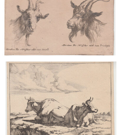
Nicolaes Pietersz Berchem (1620-1683), Animali
Nicolaes Pietersz Berchem (1620-1683), Animali è un lotto di 2 acqueforti che raffigurano Due capre And Due mucche.
Le misure delle opere sono di cm. 11×14 And cm. 9×15, con margini più piccoli.
Queste sono ottime prove su laid paper senza filigrana, al verso presentano residui di carta agli angoli superiori, a volte con minima spellatura.
- Condition: Good
Nicolaes Pietersz Berchem, noto anche come Berighem, è un pittore e incisore di grande talento, specializzato in scene pastorali popolate da personaggi mitologici e figure bibliche, ispirato dai paesaggisti italiani.
Figlio del pittore di nature morte Pieter Claesz, Berchem fu introdotto nel mondo artistico da lui e continuò il suo apprendistato sotto la guida di Jan van Goyen e Claes Cornelisz Moeyaert, rappresentando la seconda generazione di Dutch Italianes.
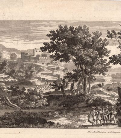
Nicolas Langlois, Paesaggio, XVII secolo
40,00 €Paesaggio con castello It is an engraving made by Nicolas Langlois in the 17th century.
Questa opera, firmata in basso a destra, è un esempio pregevole della sua arte e rappresenta un paesaggio suggestivo con un castello.
- Sheet size: cm. 18×26 circa
- Technique: Etching
- Support: Laid paper
- Condition: Excellent
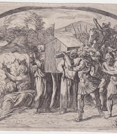
Orazio Borgianni, Arca dell’Alleanza, 1615
120,00 €Arca dell’Alleanza è un’incisione realizzata da Orazio Borgianni nel 1615, che rappresenta il Trasporto dell’arca dell’Alleanza a Gerusalemme.
Questa opera è la tavola n.39 della serie Storie bibliche dipinte nelle Logge Vaticane da Raffaello, con incisioni di Borgianni.
- Author: Sanzio Raffaello (e aiuti) (1483/1520), inventore; Borgianni Orazio (1578/1616), incisore
- Engraving size: cm. 15×19 alla battuta del rame
- Support: Laid paper
- Condition: Excellent state of preservation
- Monogramma e data: HB 1615 in lastra
- Riferimenti: Bartsch XVII.319, Charles Le Blanc, T. II, n°1-52
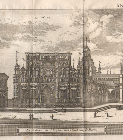
Pavia, 1707, Charterhouse
40,00 €Pavia, 1707, Charterhouse è un’incisione realizzata da Magdeleine Horthemels nel 1707, che rappresenta una veduta della Certosa di Pavia.
This work is taken from the volume The delights of Italy, pubblicato da De Rogissart a Parigi.
- Sheet size: mm. 150×120
- Technique: Burin
- Condition: Excellent
- Support: Paper

Petrus Bertius, Namur,1612
40,00 €Petrus Bertius, Namur, 1612 It is an original watercolor map, taken from Petri Bertii Geographischer eyn oder zusammengezogener Tabeln Funff unterschiedliche Bucher, published in 1612.
This small map is a significant example of 17th century cartography.
- Sheet size: cm. 12×17 approx.
- Map dimensions: mm. 125×83
- Support: Laid paper
- Condition: Excellent condition

Petrus Bertius, Normandy, 1612
40,00 €Petrus Bertius, Normandy It is an original watercolor map made in 1612 by Petrus Bertius (1565-1629).
This map is taken from the volume Petri Bertii Geographischer eyn oder zusammengezogener Tabeln Funff unterschiedliche Bucher.
- Sheet size: cm. 12×17 approx.
- Map dimensions: mm. 125×83
- Support: Laid paper
- Condition: Excellent condition

Philippus Cluverius (1580-1622), Germania, 1686
80,00 €Philippus Cluverius è un’incisione in rame acquarellata realizzata nel 1686, proveniente dall’opera Introductionis in universam geographiam, tam veterem quam novam, libri VI, published in Amsterdam.
Questa incisione rappresenta un’importante testimonianza della geografia del XVII secolo e misura mm. 134×140.
- Sheet size: Small
- Engraving size: mm. 134×140
- Support: Laid paper
- Condition: Excellent

Philippus Cluverius (1580-1622), England, 1686
80,00 €Philippus Cluverius (1580-1622) presents a map of England, part of the British Isles, dated 1686.
This copper engraving is watercolour and comes from the work Introductionis in universam geographiam, tam veterem quam novam, libri VI, published in Amsterdam in 1686.
- Sheet size: mm. 134×140
- Technique: Burin
- Support: Laid paper
- Condition: Excellent

Philippus Cluverius (1580-1622), Liguria, 1686
80,00 €Philippus Cluverius è un’incisione in rame acquarellata realizzata nel 1686, rappresentante la Liguria, Italia Settentrionale.
This work is taken from the volume Introductionis in universam geographiam, tam veterem quam novam, libri VI, published in Amsterdam.
- Sheet size: mm. 134×140
- Support: Laid paper with partial watermark
- Condition: Excellent condition

Philippus Cluverius (1580-1622), Map of Europe, 1686
80,00 €Philippus Cluverius – Map of Europe It is a watercolour copper engraving made in 1686.
This map is taken from the work Introductionis in universam geographiam, tam veterem quam novam, libri VI, published in Amsterdam.
- Sheet size: mm. 134×140
- Technique: Burin
- Support: Laid paper
- Condition: Excellent condition
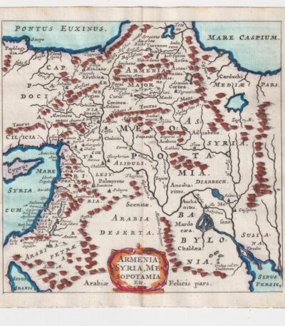
Philippus Cluverius (1580-1622), Mappa della Armenia 1686
60,00 €La Mappa della Armenia It is an engraving made by Philippus Cluverius nel 1686, che rappresenta non solo l’Armenia, ma anche la Siria e la Mesopotamia.
This map is taken from the work Introductionis in universam geographiam, tam veterem quam novam, libri VI, published in Amsterdam.
- Sheet size: mm. 134×140
- Technique: Incisione in rame acquarellata
- Support: Laid paper
- Condition: Excellent condition

Philippus Cluverius (1580-1622), Map of China, 1686
70,00 €Philippus Cluverius (1580-1622) presents a map of China and Japan, built in 1686.
This copper engraving is watercolour and comes from the work Introductionis in universam geographiam, tam veterem quam novam, libri VI, published in Amsterdam.
- Sheet size: mm. 134×140
- Technique: Burin
- Support: Laid paper
- Condition: Excellent
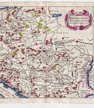
Philippus Cluverius (1580-1622), Map of Dacia, 1686
60,00 €Philippus Cluverius – Map of Dacia It is a watercolour copper engraving made in 1686.
This map represents Dacia, Hungary, Poland and Moesia, and is taken from the work Introductionis in universam geographiam, tam veterem quam novam, libri VI, published in Amsterdam.
- Sheet size: mm. 134×140
- Technique: Burin
- Support: Laid paper
- Condition: Excellent

Philippus Cluverius (1580-1622), Mappa della Francia, 1686
80,00 €La Mappa della Francia It is an engraving made by Philippus Cluverius nel 1686.
This map, part of the work Introductionis in universam geographiam, tam veterem quam novam, è un esempio significativo della cartografia del XVII secolo.
- Sheet size: cm. 13.4×14 approx.
- Engraving size: cm. 13.4×14 approx.
- Support: Laid paper
- Condition: Excellent state of preservation

Philippus Cluverius (1580-1622), Mappa della Germania 1686
60,00 €Philippus Cluverius (1580-1622) presents a Mappa della Germania Inferiore, built in 1686.
This copper engraving is watercolour and comes from the work Introductionis in universam geographiam, tam veterem quam novam, libri VI, published in Amsterdam in 1686.
- Sheet size: mm. 134×140
- Technique: Burin
- Support: Laid paper
- Condition: Excellent

Philippus Cluverius (1580-1622), Mappa della Germania, 1686
60,00 €Philippus Cluverius – Mappa della Germania It is a watercolour copper engraving made in 1686.
This map is taken from the work Introductionis in universam geographiam, tam veterem quam novam, libri VI, published in Amsterdam.
- Sheet size: mm. 134×140
- Support: Laid paper
- Condition: Excellent condition

Philippus Cluverius (1580-1622), Mappa della Germania, 1686
60,00 €Philippus Cluverius (1580-1622) presents a Map of Germany realizzata nel 1686.
Questa incisione in rame è stata acquarellata e proviene dall’opera Introductionis in universam geographiam, tam veterem quam novam, libri VI, published in Amsterdam.
- Sheet size: mm. 134×140
- Technique: Burin
- Support: Laid paper
- Condition: Excellent
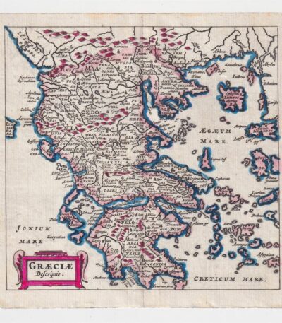
Philippus Cluverius (1580-1622), Map of Greece, 1686
60,00 €Philippus Cluverius – Map of Greece It is a watercolour copper engraving made in 1686.
This map is taken from the work Introductionis in universam geographiam, tam veterem quam novam, libri VI, published in Amsterdam.
- Sheet size: cm. 13.4×14 approx.
- Support: Laid paper
- Condition: Excellent state of preservation
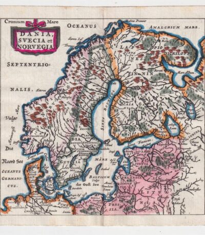
Philippus Cluverius (1580-1622), Mappa della Norvegia, 1686
80,00 €La Mappa della Norvegia di Philippus Cluverius è un’incisione in rame acquarellata realizzata nel 1686.
Questa mappa, che include anche la Svezia e la Danimarca, è tratta dall’opera Introductionis in universam geographiam, tam veterem quam novam, libri VI, published in Amsterdam.
- Sheet size: mm. 134×140
- Support: Laid paper
- Condition: Excellent condition
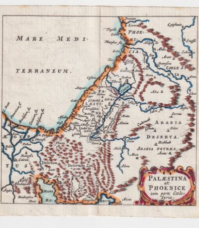
Philippus Cluverius (1580-1622), Map of Palestine, 1686
60,00 €The Map of Palestine It is an engraving made by Philippus Cluverius (1580-1622) in 1686.
This map, representing Palestine and Syria, is taken from the work Introductionis in universam geographiam, tam veterem quam novam, libri VI, published in Amsterdam.
- Sheet size: mm. 134×140
- Technique: Burin
- Support: Laid paper
- Condition: Excellent condition
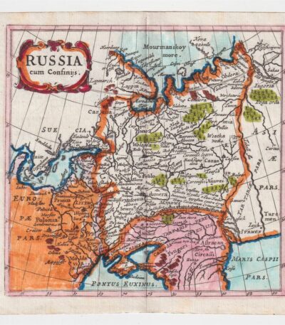
Philippus Cluverius (1580-1622), Mappa della Russia, 1686
60,00 €La Mappa della Russia It is an engraving made by Philippus Cluverius (1580-1622) in 1686.
This map is taken from the work Introductionis in universam geographiam, tam veterem quam novam, libri VI, published in Amsterdam.
- Sheet size: mm. 134×140
- Technique: Incisione in rame acquarellata
- Support: Laid paper
- Condition: Excellent condition

Philippus Cluverius (1580-1622), Map of Spain, 1686
80,00 €Philippus Cluverius – Mappa della Spagna It is a watercolour copper engraving made in 1686.
This map is taken from the work Introductionis in universam geographiam, tam veterem quam novam, libri VI, published in Amsterdam.
- Sheet size: mm. 134×140
- Technique: Burin
- Support: Laid paper
- Condition: Excellent condition
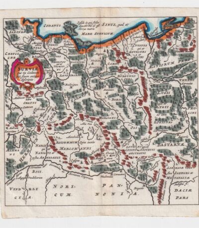
Philippus Cluverius (1580-1622), Mappa della Suevia, 1686
60,00 €Philippus Cluverius (1580-1622) presenta la sua Mappa della Suevia, un’incisione in rame acquarellata realizzata nel 1686.
Questa mappa, che rappresenta la regione della Suevia in Germania, è tratta dall’opera Introductionis in universam geographiam, tam veterem quam novam, libri VI, published in Amsterdam.
- Sheet size: mm. 134×140
- Technique: Burin
- Support: Laid paper
- Condition: Excellent
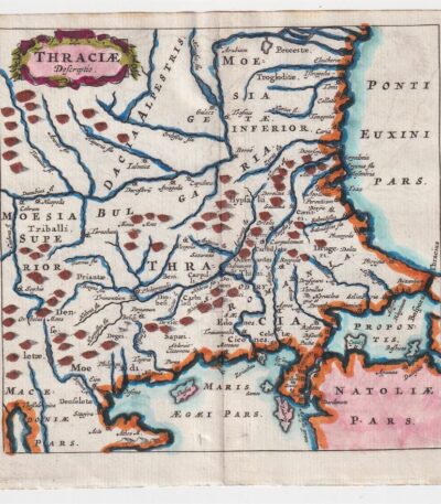
Philippus Cluverius (1580-1622), Mappa della Tracia, 1686
60,00 €La Mappa della Tracia è un’incisione realizzata da Philippus Cluverius nel 1686, che rappresenta la Tracia, la Dacia e la Bulgaria.
This map is taken from the work Introductionis in universam geographiam, tam veterem quam novam, libri VI, published in Amsterdam.
- Sheet size: mm. 134×140
- Technique: Burin
- Support: Laid paper
- Condition: Excellent
