
XVII
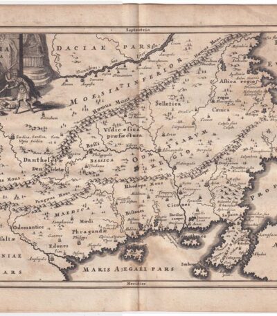
Cellarius, Tracia, 1701
60,00 €Cellarius, Tracia It is a copperplate map made by Christophorus Cellarius in 1701.
This engraving is taken from the work Notitia Orbis Antiqui sive Geographia Plenior, un’importante fonte di geografia antica.
- Sheet size: cm. 24×33 approx.
- Engraving size: cm. 20×30 approx.
- Support: Paper
- Condition: Excellent
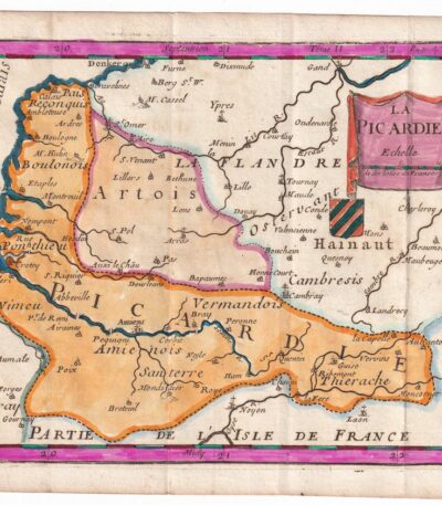
Charles Inselin, Map of Picardie France 1707
40,00 €Map of Picardy It is an engraving made by Charles Inselin in 1707.
This watercolor map depicts the Picardy region of France.
- Sheet size: cm. 16×23 approx.
- Engraving size: cm. 14×18 approx.
- Technique: Etching
- Condition: Excellent
- Support: Paper
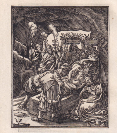
Christoffel van Sichem, Deposition of Christ, 1646
30,00 €Deposition of Christ It is an engraving made by Christoffel of Shechem In the 1646, inspired by a subject of Hendrick Goltzius.
This woodcut is printed on laid paper and has dimensions of approximately cm. 11×9, with smaller margins. On the back there is another partial image. The work is monogrammed on the plate with the initials CVS and it is taken from the volume Bibels tresoor, ofte Der zielen lvsthof, published by Pieter Jacobsz Paets in Amsterdam in 1646.
- Era: XVII
- Technique: Woodcut
- Condition: Excellent
- Dimensions: Small
- Support: Paper

Claude Lorrain, The Cowherd, 1670, 19th century
30,00 €Il Bovaro It is an engraving made by Claude Lorrain nel 1670, un’opera che rappresenta il maestro del paesaggio ideale.
Questa incisione è stata eseguita da Amand Durand nel XIX secolo e si distingue per la sua eleganza e il suo stile raffinato.
- Sheet size: cm. 28×19 approx.
- Engraving size: cm. 13×20 approx.
- Support: Laid paper without watermark
- Condition: Excellent state of preservation

Cornelis Galle, Naval Battle, 17th century.
50,00 €Naval Battle It is an engraving made by Cornelis Galle in the 17th century.
This etching on laid paper It measures approximately 85 x 125 mm, excluding the margins, and depicts a lively naval battle scene.
The work is signed lower right with the initials C.Galle, but the attribution between Cornelis Galle the Elder and the Younger remains uncertain.
- Sheet size: mm. 85×125 approx.
- Condition: Good, with small defects on the two lower edges
- Support: Laid paper

Watering Can Maker, Caspar and Jan Luyken, 1694
15,00 €Costruttore di Annaffiatoi It is a woodcut made by Caspar and Jan Luyken in 1694.
This work is taken from Spiegel van het Menselyk Bedryf (Mirror of Human Activities) e presenta un’illustrazione dettagliata del mestiere di costruttore di annaffiatoi.
Nel foglio, oltre alla xilografia, sono presenti note esplicative in olandese, e il retro è anch’esso stampato.
- Sheet size: mm. 75×120
- Engraving size: mm. 60×64
- Support: Laid paper
- Condition: Excellent

Bricchi builder, Caspar and Jan Luyken, 1694
15,00 €Costruttore di Bricchi è un’incisione realizzata da Caspar e Jan Luyken nel 1694.
This woodcut is taken from the work Spiegel van het Menselyk Bedryf (Mirror of Human Activities) e presenta un’illustrazione dettagliata del mestiere del costruttore di bricchi.
- Sheet size: mm. 75×120
- Engraving size: mm. 60×64
- Technique: Woodcut
- Support: Laid paper without watermark
- Condition: Excellent
In addition to the image, the sheet includes explanatory notes in Dutch and also features a print on the back.

Crispijn van den Queborn Rape of the Vineyard, 1636
25,00 €Rape of the Vineyard It is an engraving made by Crispijn van den Queborn in 1636, which represents a significant biblical episode concerning the rape of the vineyard and the Benjaminites.
Benjamin, Rachel's second son, is at the center of this narrative.
- Sheet size: cm. 10×13 approx.
- Technique: Etching
- Support: Laid paper
- Condition: Excellent state of preservation
Crispijn van den Queborn (1604-1652), Episodio biblico, 1636
25,00 €Episodio biblico It is an engraving made by Crispijn van den Queborn nel 1636.
Questa opera è un esempio significativo dell’arte olandese del XVII secolo, caratterizzata da un’accurata rappresentazione dei temi religiosi.
- Sheet size: cm. 20×14 approx.
- Technique: Etching
- Support: Laid paper
- Condition: Excellent
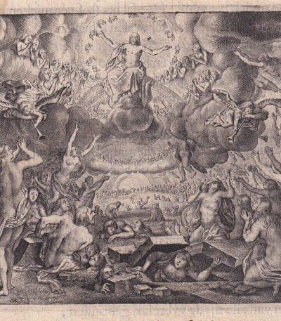
Crispijn van den Queborn (1604-1652), Resurrection 1636
30,00 €The Resurrection of the Dead It is an engraving made by Crispijn van den Queborn in 1636.
This work, which represents a theme of great visual and symbolic impact, is a significant example of 17th-century Dutch art.
- Sheet size: cm. 10×13 approx.
- Technique: Etching
- Support: Laid paper
- Condition: Excellent state of preservation

Crispijn van den Queborn, Massacre of the Innocents, 1636
30,00 €Massacre of the Innocents It is an engraving made by Crispijn van den Queborn In the 1636.
This work is a significant example of the mastery of the Dutch engraver, who was able to capture the intensity of the subject through his technique.
- Sheet size: cm. 10×13 approx.
- Technique: Etching
- Support: Laid paper
- Condition: Excellent state of preservation
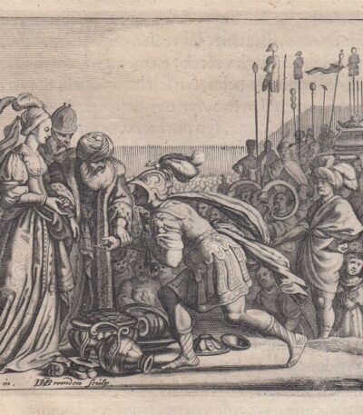
D.van den Bremden, A.van de Venne, 1636
25,00 €Kaleb and the Philistines è un’incisione realizzata da D.van den Bremden nel 1636, in collaborazione con A.van de Venne.
Questo episodio biblico rappresenta un momento significativo della storia, illustrato con maestria attraverso la tecnica dell’acquaforte.
- Sheet size: cm. 10×13 approx.
- Technique: Etching
- Support: Laid paper with partial watermark
- Condition: Excellent

D.van den Bremden, A.van de Venne 1636
25,00 €Jacob and Rachel It is an engraving made by D.van den Bremden nel 1636, in collaborazione con A.van de Venne.
Questo episodio biblico rappresenta Giacobbe che si lamenta con Laban per aver ricevuto Lea invece di Rachele come moglie.
- Sheet size: cm. 10×13 approx.
- Technique: Etching
- Support: Laid paper
- Condition: Excellent state of preservation

Danker Dankerts, Berchem, Landscape
80,00 €Paesaggio con Contadini e Animali It is an engraving made by Danker Dankerts, inspired by the works of Nicolaes Berchem, risalente al 17th century.
This work represents a paesaggio con buoi ed è firmata al centro della scena con la dicitura Berchem inventor Danker Dankerts fecit.
- Sheet size: cm. 18×24 alla battuta del rame più margini
- Technique: Etching
- Support: Laid paper
- Condition: Excellent

Danker Dankerts, Berchem, Landscape
80,00 €Paesaggio con Contadini e Animali It is an engraving made by Danker Dankerts nel XVII secolo, ispirata ai paesaggi rurali.
Questa opera, che rappresenta un paesaggio con buoi, è firmata in lastra da Berchem e realizzata con la tecnica dell’Etching.
- Sheet size: cm. 18×24 approx.
- Support: Laid paper
- Condition: Excellent

Danker Dankerts, Berchem, Landscape
80,00 €Paesaggio con Contadini e Animali It is an engraving made by Danker Dankerts (1634-1666), ispirata ai paesaggi di Nicolaes Berchem (1620-1683).
Questa opera, datata al 17th century, rappresenta un affascinante paesaggio con buoi, eseguita in etching on laid paper.
- Sheet size: cm. 18×24 alla battuta del rame più margini
- Condition: Excellent
- Firmata in lastra: Berchem inventor Danker Dankerts fecit

Danker Dankerts, Berchem, Paesaggio montano
140,00 €Mountain landscape It is an engraving made by Danker Dankerts (1634-1666) su disegno di Nicolaes Berchem (1620-1683), risalente al 17th century.
This work represents a paesaggio con asini e contadino, eseguita in etching on laid paper.
- Sheet size: cm. 18×24 alla battuta del rame più margini
- Condition: Excellent
- Signed: in basso Berchem inventor Danker Dankerts fecit

By Fer Nicolas, Naples, 1706
220,00 €By Fer Nicolas, Naples, 1706 It is a copper engraving that offers a perspective view of the city of Naples, enriched by 31 references located in the lower part.
This copy is made on slightly yellowed paper, giving a touch of historical authenticity to the work.
- Sheet size: cm. 22.7×33.8 approx.
- Engraving size: cm. 22.7×33.8 approx.
- Support: Paper
- Condition: Excellent state of preservation
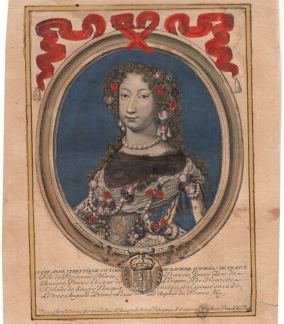
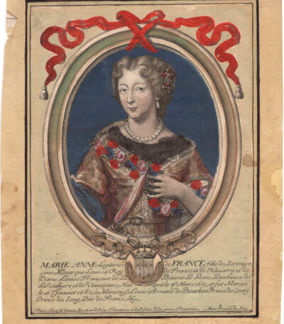
de Larmessin, Nicolas (1632-1694), 1680
40,00 €Maria Anna Christienne Victoire de Baviere è un’acquaforte acquarellato realizzata da Nicolas de Larmessin nel 1680.
This work, signed De L’Armessin, sculpsit, è un esempio pregevole dell’arte del XVII secolo.
- Sheet size: cm. 25×18 approx.
- Support: Laid paper
- Condition: Buone, con strappo di 10 cm riparato al verso con carta

de Larmessin, Nicolas (1632-1694), 1680
40,00 €Luigi D’Auphin è un’acquaforte acquarellata realizzata da Nicolas de Larmessin nel 1680.
Questa opera ritrae il figlio di Luigi il Grande e di Maria Teresa d’Austria, ed è firmata De L’Armessin, sculpsit.
- Sheet size: cm. 25×18 approx.
- Technique: Etching
- Condition: Excellent
- Support: Laid paper
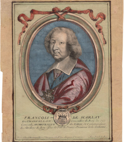
de Larmessin, Nicolas (1632-1694), 1680
40,00 €Francois de Harlay Chanvallon It is an engraving made by Nicolas de Larmessin nel 1680.
Questa opera rappresenta l’arcivescovo di Parigi ed è un esempio di watercolor etching di grande valore storico.
- Sheet size: cm. 25×18 approx.
- Technique: Burin
- Condition: Excellent
- Support: Laid paper
de Larmessin, Nicolas (1632-1694), 1680
40,00 €Mara Anna, figlia del re Luigi XIV è un’incisione realizzata da Nicolas de Larmessin nel 1680.
This watercolor etching d’epoca è un esempio pregiato dell’arte incisoria del XVII secolo.
- Sheet size: cm. 25×18 approx.
- Support: Laid paper
- Condition: Excellent state of preservation

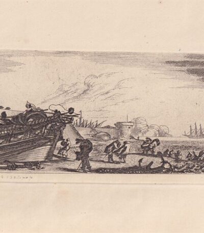
Della Bella, Various Vessels
60,00 €Various Vessels It is an engraving made by Stephen Of The Beautiful in the 17th century.
This work, part of the series Various Boardings, is a reverse copy and has a signature on the lower left with the initials SDBella.
- Sheet size: cm. 17×32 approx.
- Engraving size: cm. 8×16 approx.
- Technique: Etching
- Support: Thick ivory-colored unlaid paper
- Condition: Perfect
The plates of these copies belong to the Calcografia of Rome.
Della Bella, Various Vessels
60,00 €Various Vessels it is an etching made by Stephen Of The Beautiful in the 19th century, originally conceived in the 17th century.
This work, signed lower left with the initials SDBella, is a copy in reverse of the series Various Boardings (DeVesme/Massar, 802-809).
- Sheet size: cm. 17×32
- Engraving size: cm. 8×16
- Technique: Etching
- Support: Thick ivory-colored unlaid paper
- Condition: Excellent
The plates of these copies belong to the Calcografia of Rome.
