Foreign Maps and Papers

Petrus Bertius, Normandy, 1612
40,00 €Petrus Bertius, Normandy It is an original watercolor map made in 1612 by Petrus Bertius (1565-1629).
This map is taken from the volume Petri Bertii Geographischer eyn oder zusammengezogener Tabeln Funff unterschiedliche Bucher.
- Sheet size: cm. 12×17 approx.
- Map dimensions: mm. 125×83
- Support: Laid paper
- Condition: Excellent condition

Petrus Bertius, Vaucluse, 1612
40,00 €Petrus Bertius, Vaucluse It is an original watercolor map made in 1612 by Petrus Bertius (1565-1629).
This map is taken from Petri Bertii Geographischer eyn oder zusammengezogener Tabeln Funff unterschiedliche Bucher.
- Sheet size: cm. 12×17 approx.
- Map dimensions: mm. 125×83
- Support: Laid paper
- Condition: Excellent condition

Petrus Bertius, Veromadui,1612
40,00 €Petrus Bertius, Veromadui It is an original watercolor map made in 1612 by Petrus Bertius, a well-known French geographer.
This map is taken from Petri Bertii Geographischer eyn oder zusammengezogener Tabeln Funff unterschiedliche Bucher, pubblicato nello stesso anno.
- Sheet size: cm. 12×17 approx.
- Map dimensions: mm. 125×83
- Support: Laid paper
- Condition: Excellent condition

Petrus Bertius, Westfalia,1612
40,00 €Petrus Bertius, Westfalia è una mappa originale acquarellata realizzata nel 1612 da Petrus Bertius, un geografo di origine olandese.
This map is taken from the volume Petri Bertii Geographischer eyn oder zusammengezogener Tabeln Funff unterschiedliche Bucher.
- Sheet size: cm. 12×17 approx.
- Map dimensions: mm. 125×83
- Support: Laid paper
- Condition: Excellent condition

Philippus Cluverius (1580-1622), Germania, 1686
80,00 €Philippus Cluverius è un’incisione in rame acquarellata realizzata nel 1686, proveniente dall’opera Introductionis in universam geographiam, tam veterem quam novam, libri VI, published in Amsterdam.
Questa incisione rappresenta un’importante testimonianza della geografia del XVII secolo e misura mm. 134×140.
- Sheet size: Small
- Engraving size: mm. 134×140
- Support: Laid paper
- Condition: Excellent

Philippus Cluverius (1580-1622), England, 1686
80,00 €Philippus Cluverius (1580-1622) presents a map of England, part of the British Isles, dated 1686.
This copper engraving is watercolour and comes from the work Introductionis in universam geographiam, tam veterem quam novam, libri VI, published in Amsterdam in 1686.
- Sheet size: mm. 134×140
- Technique: Burin
- Support: Laid paper
- Condition: Excellent

Philippus Cluverius (1580-1622), Map of Europe, 1686
80,00 €Philippus Cluverius – Map of Europe It is a watercolour copper engraving made in 1686.
This map is taken from the work Introductionis in universam geographiam, tam veterem quam novam, libri VI, published in Amsterdam.
- Sheet size: mm. 134×140
- Technique: Burin
- Support: Laid paper
- Condition: Excellent condition
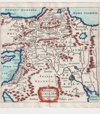
Philippus Cluverius (1580-1622), Mappa della Armenia 1686
60,00 €La Mappa della Armenia It is an engraving made by Philippus Cluverius nel 1686, che rappresenta non solo l’Armenia, ma anche la Siria e la Mesopotamia.
This map is taken from the work Introductionis in universam geographiam, tam veterem quam novam, libri VI, published in Amsterdam.
- Sheet size: mm. 134×140
- Technique: Incisione in rame acquarellata
- Support: Laid paper
- Condition: Excellent condition

Philippus Cluverius (1580-1622), Map of China, 1686
70,00 €Philippus Cluverius (1580-1622) presents a map of China and Japan, built in 1686.
This copper engraving is watercolour and comes from the work Introductionis in universam geographiam, tam veterem quam novam, libri VI, published in Amsterdam.
- Sheet size: mm. 134×140
- Technique: Burin
- Support: Laid paper
- Condition: Excellent
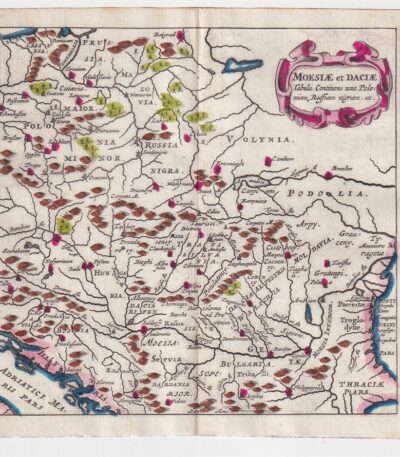
Philippus Cluverius (1580-1622), Map of Dacia, 1686
60,00 €Philippus Cluverius – Map of Dacia It is a watercolour copper engraving made in 1686.
This map represents Dacia, Hungary, Poland and Moesia, and is taken from the work Introductionis in universam geographiam, tam veterem quam novam, libri VI, published in Amsterdam.
- Sheet size: mm. 134×140
- Technique: Burin
- Support: Laid paper
- Condition: Excellent

Philippus Cluverius (1580-1622), Mappa della Francia, 1686
80,00 €La Mappa della Francia It is an engraving made by Philippus Cluverius nel 1686.
This map, part of the work Introductionis in universam geographiam, tam veterem quam novam, è un esempio significativo della cartografia del XVII secolo.
- Sheet size: cm. 13.4×14 approx.
- Engraving size: cm. 13.4×14 approx.
- Support: Laid paper
- Condition: Excellent state of preservation

Philippus Cluverius (1580-1622), Mappa della Germania 1686
60,00 €Philippus Cluverius (1580-1622) presents a Mappa della Germania Inferiore, built in 1686.
This copper engraving is watercolour and comes from the work Introductionis in universam geographiam, tam veterem quam novam, libri VI, published in Amsterdam in 1686.
- Sheet size: mm. 134×140
- Technique: Burin
- Support: Laid paper
- Condition: Excellent

Philippus Cluverius (1580-1622), Mappa della Germania, 1686
60,00 €Philippus Cluverius – Mappa della Germania It is a watercolour copper engraving made in 1686.
This map is taken from the work Introductionis in universam geographiam, tam veterem quam novam, libri VI, published in Amsterdam.
- Sheet size: mm. 134×140
- Support: Laid paper
- Condition: Excellent condition

Philippus Cluverius (1580-1622), Mappa della Germania, 1686
60,00 €Philippus Cluverius (1580-1622) presents a Map of Germany realizzata nel 1686.
Questa incisione in rame è stata acquarellata e proviene dall’opera Introductionis in universam geographiam, tam veterem quam novam, libri VI, published in Amsterdam.
- Sheet size: mm. 134×140
- Technique: Burin
- Support: Laid paper
- Condition: Excellent
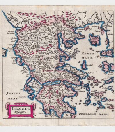
Philippus Cluverius (1580-1622), Map of Greece, 1686
60,00 €Philippus Cluverius – Map of Greece It is a watercolour copper engraving made in 1686.
This map is taken from the work Introductionis in universam geographiam, tam veterem quam novam, libri VI, published in Amsterdam.
- Sheet size: cm. 13.4×14 approx.
- Support: Laid paper
- Condition: Excellent state of preservation
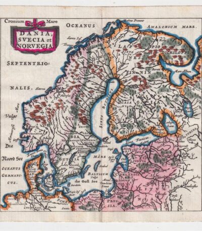
Philippus Cluverius (1580-1622), Mappa della Norvegia, 1686
80,00 €La Mappa della Norvegia di Philippus Cluverius è un’incisione in rame acquarellata realizzata nel 1686.
Questa mappa, che include anche la Svezia e la Danimarca, è tratta dall’opera Introductionis in universam geographiam, tam veterem quam novam, libri VI, published in Amsterdam.
- Sheet size: mm. 134×140
- Support: Laid paper
- Condition: Excellent condition
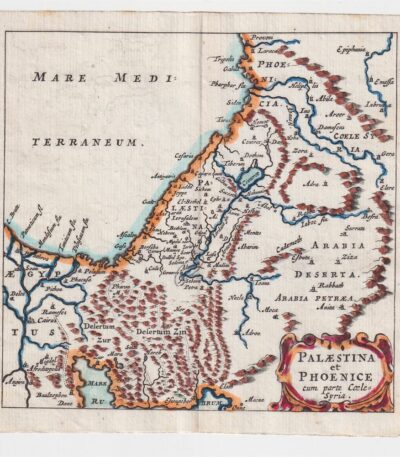
Philippus Cluverius (1580-1622), Map of Palestine, 1686
60,00 €The Map of Palestine It is an engraving made by Philippus Cluverius (1580-1622) in 1686.
This map, representing Palestine and Syria, is taken from the work Introductionis in universam geographiam, tam veterem quam novam, libri VI, published in Amsterdam.
- Sheet size: mm. 134×140
- Technique: Burin
- Support: Laid paper
- Condition: Excellent condition
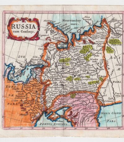
Philippus Cluverius (1580-1622), Mappa della Russia, 1686
60,00 €La Mappa della Russia It is an engraving made by Philippus Cluverius (1580-1622) in 1686.
This map is taken from the work Introductionis in universam geographiam, tam veterem quam novam, libri VI, published in Amsterdam.
- Sheet size: mm. 134×140
- Technique: Incisione in rame acquarellata
- Support: Laid paper
- Condition: Excellent condition

Philippus Cluverius (1580-1622), Map of Spain, 1686
80,00 €Philippus Cluverius – Mappa della Spagna It is a watercolour copper engraving made in 1686.
This map is taken from the work Introductionis in universam geographiam, tam veterem quam novam, libri VI, published in Amsterdam.
- Sheet size: mm. 134×140
- Technique: Burin
- Support: Laid paper
- Condition: Excellent condition
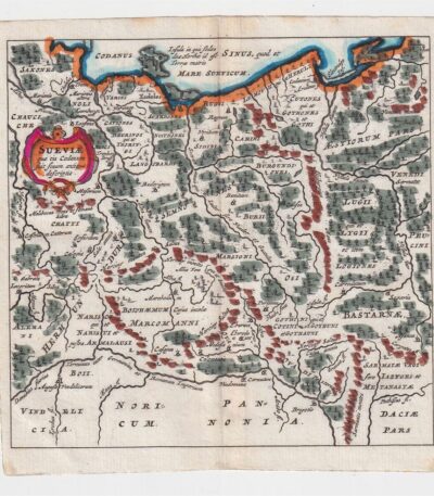
Philippus Cluverius (1580-1622), Mappa della Suevia, 1686
60,00 €Philippus Cluverius (1580-1622) presenta la sua Mappa della Suevia, un’incisione in rame acquarellata realizzata nel 1686.
Questa mappa, che rappresenta la regione della Suevia in Germania, è tratta dall’opera Introductionis in universam geographiam, tam veterem quam novam, libri VI, published in Amsterdam.
- Sheet size: mm. 134×140
- Technique: Burin
- Support: Laid paper
- Condition: Excellent
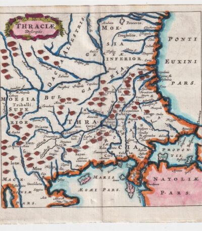
Philippus Cluverius (1580-1622), Mappa della Tracia, 1686
60,00 €La Mappa della Tracia è un’incisione realizzata da Philippus Cluverius nel 1686, che rappresenta la Tracia, la Dacia e la Bulgaria.
This map is taken from the work Introductionis in universam geographiam, tam veterem quam novam, libri VI, published in Amsterdam.
- Sheet size: mm. 134×140
- Technique: Burin
- Support: Laid paper
- Condition: Excellent
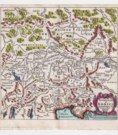
Philippus Cluverius (1580-1622), Mappa della Vindelicia, 1686
60,00 €La Mappa della Vindelicia It is an engraving made by Philippus Cluverius (1580-1622) in 1686.
Questa mappa rappresenta la regione della Vindelicia, situata in Germania, ed è parte dell’opera Introductionis in universam geographiam, tam veterem quam novam, libri VI, published in Amsterdam.
- Sheet size: mm. 134×140
- Technique: Burin
- Support: Laid paper
- Condition: Excellent condition
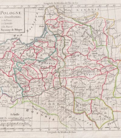
Polonia, C.F. Delamarche, 1816
70,00 €Polonia, C.F. Delamarche, 1816 è una mappa dettagliata della Polonia, che illustra i suoi dipartimenti.
This copper engraving is colored around the outline and is taken from the volume Petit Atlas Moderne ou Collection de Cartes Elementaires, dedicato alla gioventù e pubblicato a Parigi da Delamarche nel 1816.
- Sheet size: cm. 21×27 approx.
- Support: Paper
- Condition: Good condition, with some peeling and a central editorial crease

Dutch possessions, Otto Petri, 1853
50,00 €Possedimenti Olandesi è un’incisione colorata a mano realizzata da Otto Petri nel 1853.
Questa mappa rappresenta i possedimenti olandesi d’oltremare, inclusi Java e Borneo, ed è tratta dal School Atlas Alle Deelen Der Aarde, published by J. Van Den Bosch in Rotterdam.
- Sheet size: cm. 26×34 approx.
- Engraving size: cm. 22×27 approx.
- Support: Medium thickness paper
- Condition: Excellent state of preservation
