
Map of Venice, 1873
30,00 €Map of Venice It is a copper engraving made in 1873 by P. Allodi, who took care of both the drawing and the engraving.
This map is taken from the publication Guide in Italy, published by the Artaria company of Milan.
- Sheet size: cm. 15.5x20.5 approx.
- Support: Paper
- Condition: Excellent condition
- Characteristics: White back with legend of the most important sites of the city, features an editorial fold.
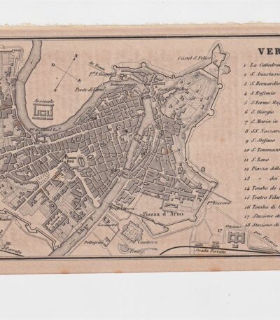
Map of Verona, 1873
25,00 €Mappa di Verona It is a copper engraving made in 1873, part of the publication Guide in Italy, curata dal cav. P.E. Sacchi e stampata dalla ditta Artaria di Milano.
Questa mappa offre una rappresentazione dettagliata della città, con una legenda che indica i siti più importanti.
- Sheet size: cm. 15.5x9.5 approx.
- Support: Paper
- Condition: Excellent condition

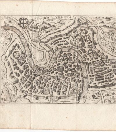
Mappa di Verona, de Rogissart, 1707
50,00 €Incisione realizzata nel 1707, utilizzando la tecnica dell’acquaforte su rame.
Questa opera è stampata su carta leggera vergellata con retro bianco.
It is part of the volume Les delices de l’Italie di De Rogissart, edizione francese, pubblicata a Parigi nel 1707.
- Sheet size: cm. 19×16 circa
- Dimensioni dell’incisione: cm. 10×14 circa
- Support: Laid paper
- Condition: Ottime condizioni. Due pieghe editoriali.
Map of Verona, Scotus, 1761
90,00 €Mappa di Verona it is a copper engraving made in 1761 by Francesco Scotto.
This map is part of the work Itinerary of Italy, pubblicata a Roma da Fausto Amidei.
- Sheet size: cm. 18×23 approx.
- Engraving size: cm. 12×18 approx.
- Support: Laid paper
- Condition: Excellent condition

Map of Vicenza, 1873
25,00 €Mappa di Vicenza It is a copper engraving made in 1873.
This map is taken from the Guide in Italy, edited by Cav. PE Sacchi and published by the Artaria company of Milan.
- Sheet size: cm. 15.5x9.5 approx.
- Back: White
- Legenda: Siti più importanti della città
- Condition: Excellent condition

Map of Vicenza, Scotus, 1761
90,00 €Mappa di Vicenza It is a copper engraving made in 1761 by Francesco Scotto.
This map is part of the work Itinerary of Italy, published in Rome at the expense of Fausto Amidei, Book Merchant.
- Sheet size: cm. 18×23 approx.
- Engraving size: cm. 12×18 approx.
- Support: Laid paper
- Condition: Excellent state of preservation
- Folds: Editorial folds

Mappa di Vicovaro, Roma, Lazio, Munster, dalla Cosmographia Universalis, 1614
Vicovaro, Munster, 1614 It is a page extracted from the Cosmography Universalis by Sebastian Munster, which offers a suggestive view of Vicovaro, located in Lazio.
This engraving is a fine example of woodcut on watercolour laid paper, with writing on the reverse.
- Sheet size: cm. 36×22 approx.
- Image size: cm. 12×15 approx.
- Support: Laid paper
- Condition: Excellent
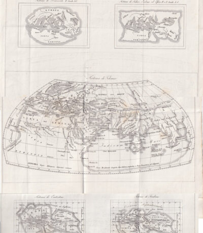
Maps of Europe, 1846
50,00 €Mappe dell’Europa è un’incisione in rame del 1846, che presenta una serie di mappe storiche dell’Europa, tra cui i sistemi di Democrito, Scilace, Eudosso, Eforo, Tolomeo ed Eratostene.
This work is taken from the Storia Universale di Cesare Cantù, pubblicata a Torino presso gli Editori Giuseppe Pomba & C.
- Sheet size: cm. 42×27 circa
- Technique: Copper engraving
- Condition: Buone condizioni con varie pieghe editoriali
- Support: Paper
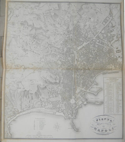
Naples, City Plan, Vallardi, 1867
240,00 €Napoli, Pianta della Città It is a copper engraving made in 1867 da Vallardi.
Questa dettagliata carta geografica fa parte dell’Atlante geografico dell’Italia, pubblicato a Milano.
La pianta offre una chiara rappresentazione delle principali località e delle sezioni della città, rendendola un prezioso documento storico.
- Sheet size: cm. 56,8×67,8 circa
- Engraving size: cm. 56,8×67,8 circa
- Support: Paper
- Condition: Excellent

Neptune, St. Munster, 1614
Neptune It is a page extracted from the Cosmography Universalis by Sebastian Munster, published in Basel in 1614.
This work represents a color map of Neptune, located near Rome, and on the back is a portrait of Andrea Doria.
- Author: Sebastian Münster (1488-1552)
- Sheet size: cm. 36×22 approx.
- Image size: cm. 12.5x15.5 approx.
- Technique: Woodcut
- Support: Watercolored laid paper
- Condition: Excellent

Pesaro, Salmon Thomas, 1738-1768
40,00 €Pesaro it is an etching on copper made by Thomas Salmon between 1738 and 1768.
This work represents the city of Pesaro in the Duchy of Urbino, part of the Ecclesiastical State.
- Size of the joke: cm. 15×10 approx.
- Margins: Irregular
- Technique: Etching on copper
- Support: Laid paper without watermark
- Condition: Excellent state of preservation
The work is taken from the volume The present state of all the Countries, and Peoples of the World, Natural, Political, and Moral…, Naples edition.

Philippus Cluverius (1580-1622), Liguria, 1686
80,00 €Philippus Cluverius è un’incisione in rame acquarellata realizzata nel 1686, rappresentante la Liguria, Italia Settentrionale.
This work is taken from the volume Introductionis in universam geographiam, tam veterem quam novam, libri VI, published in Amsterdam.
- Sheet size: mm. 134×140
- Support: Laid paper with partial watermark
- Condition: Excellent condition

Philippus Cluverius, map of Central Italy, 1686
90,00 €Philippus Cluverius, mappa dell’Italia Centrale It is a watercolour copper engraving made in 1686.
Questa mappa rappresenta le regioni dell’Etruria, Lazio e Umbria ed è tratta dall’opera Introductionis in universam geographiam, tam veterem quam novam, libri VI, published in Amsterdam.
- Sheet size: mm. 134×140
- Technique: Burin
- Support: Laid paper
- Condition: Excellent
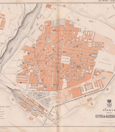
Pianta della città di Alessandria, 1890
30,00 €Pianta della città di Alessandria It is a woodcut print made in 1890 by the engraver Barberis.
Questa opera è tratta da un testo italiano di fine Ottocento e presenta un design dettagliato della città.
- Sheet size: cm. 24×28 circa
- Support: Paper
- Condition: Buone, con fori e tagli al centro dovuti all’impaginazione
Si precisa che verrà spedito l’intero foglio che contiene la stampa.
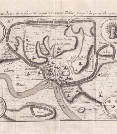
Map of Rome, 1791
80,00 €Pianta di Roma, made in 1791, è un’acquaforte su carta vergellata che offre una vista dettagliata della città eterna.
Questa pianta, parte dell’opera Histoire Universelle depuis les commencement du monde jusque a present, pubblicata a Parigi, rappresenta l’evoluzione di Roma dai tempi di Servio Tullio fino alla conquista da parte dei Galli.
- Sheet size: cm. 16×33 alla linea marginale, con margini irregolari di 2-7 cm
- Technique: Etching
- Condition: Excellent
- Support: Laid paper
Ai lati della pianta si trovano le legende dei siti indicati e numerati, rendendo questa opera non solo un documento storico, ma anche un utile strumento di riferimento.
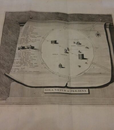
Pierre Vander AA, Plan of the city of Nola, 1729
Map of the city of Nola It is an engraving made by Pierre Vander AA in 1729, taken from the volume Thesaurus antiquitatum et historiarum Italiae.
This map, from Leiden, offers a detailed representation of the city of Nola, located in the province of Naples.
The map includes a legend explaining the various locations, making it not only a work of art, but also an important historical resource.
- Sheet size: cm. 33×25 approx.
- Engraving size: cm. 47×40 approx.
- Technique: Etching
- Support: Laid paper
- Condition: Excellent
- Rarity: Extremely rare

Pierre Vander AA, Plan of the city of Nola, 1729
Map of the city of Nola It is an engraving made by Pierre Vander AA in 1729, taken from the Thesaurus antiquitatum et historiarum Italiae.
This detailed map represents the city of Nola, located in the province of Naples, and was created using the etching technique on laid paper.
- Sheet size: cm. 40×24 approx.
- Engraving size: cm. 18×24 approx.
- Support: Laid paper
- Condition: Excellent
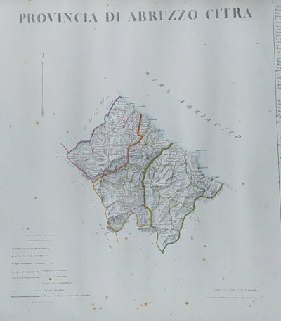
Provincia di Abruzzo Citra, B. Marzolla, 1832
90,00 €Provincia di Abruzzo Citra it is a geographical map created by B. Marzolla in 1832.
Questa opera è stata eseguita in lithography con confini acquarellati e fa parte dell’ Historical and statistical chorographic atlas of the Kingdom of the Two Sicilies, dedicated to HM King Ferdinand II.
- Sheet size: cm. 45×60
- Condition: Good state of preservation
- Support: Paper
La carta presenta macchie del tempo e leggere gore di umidità, ma è priva di pieghe editoriali. Ai lati sono riportate notizie storiche e statistiche della provincia.
The card will be shipped in a rigid tube via registered mail.
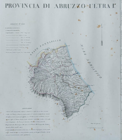
Provincia di Abruzzo Ultra I, B. Marzolla, 1832
90,00 €Provincia di Abruzzo Ultra I it is a geographical map created by B. Marzolla in 1832.
Questa opera è parte dell’Historical and statistical chorographic atlas of the Kingdom of the Two Sicilies, eseguito litograficamente e dedicato a S.M. il Re Ferdinando II.
- Sheet size: cm. 45×60
- Paper size: Great
- Technique: Lithography
- Condition: Good state of preservation
- Support: Paper
La carta presenta confini acquarellati e include notizie storiche e statistiche della provincia. Si notano alcune macchie del tempo e leggere gore di umidità, ma il foglio è privo di pieghe editoriali.
La spedizione avverrà in tubo rigido con posta raccomandata.
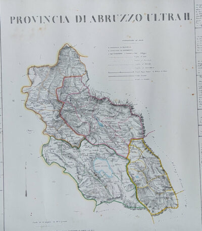
Provincia di Abruzzo Ultra II, B. Marzolla, 1832
90,00 €Provincia di Abruzzo Ultra II it is a geographical map created by B. Marzolla in 1832.
This lithograph has watercolored borders and is part of the work Historical and statistical chorographic atlas of the Kingdom of the Two Sicilies, dedicated to HM King Ferdinand II.
- Sheet size: cm. 45×60
- Paper size: Great
- Technique: Lithography
- Condition: Good state of preservation
- Support: Paper
The paper has some age stains and light humidity stains, but is free of editorial creases.
It will be shipped in a rigid tube with registered mail.
Provincia di Agrigento, B. Marzolla, 1832
Provincia di Agrigento It is a geographical map created by B. Marzolla in 1832, executed in lithography with watercolor borders.
This map is part of the work Historical and statistical chorographic atlas of the Kingdom of the Two Sicilies, compilato e dedicato a S.M. il Re Ferdinando II, pubblicato a Napoli dalla Reale Tipografia Milit. nel 1832.
- Sheet size: cm. 45×60
- Condition: Good state of preservation
- Support: Paper
La carta presenta macchie del tempo e leggere gore di umidità, ma è priva di pieghe editoriali. Ai lati, sono riportate notizie storiche e statistiche della provincia. La spedizione avverrà in tubo rigido con posta raccomandata.

Province of Bari, B. Marzolla, 1832
80,00 €Province of Bari It is a geographical map made by Benedict Marzolla in 1832, performed in lithography with watercolor borders.
This map is part of the work Historical and statistical chorographic atlas of the Kingdom of the Two Sicilies, dedicated to HM King Ferdinand II.
- Sheet size: cm. 45×60
- Condition: Good state of preservation
- Support: Paper
The paper has age stains and light humidity stains, but is free of editorial creases.
On the sides, there are historical and statistical information about the provinces of Bari, Trani, Monopoli, Andria and Molfetta. The map will be sent in a rigid tube with registered mail.

Province of Bari, B. Marzolla, 1832
90,00 €Province of Bari it is a geographical map created by B. Marzolla in 1832.
This map was made in lithography with watercolor borders and is part of the work Historical and statistical chorographic atlas of the Kingdom of the Two Sicilies, dedicated to HM King Ferdinand II.
- Sheet size: cm. 45×60
- Condition: Good state of preservation
- Support: Paper
- Notes: Stains of time and light humidity stains, sheet without editorial fold
