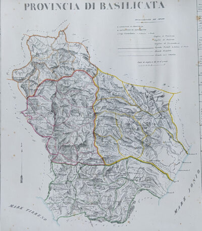
Provincia di Basilicata, B. Marzolla, 1832
90,00 €Provincia di Basilicata it is a geographical map created by B. Marzolla in 1832.
This lithograph has watercolored borders and is part of the work Historical and statistical chorographic atlas of the Kingdom of the Two Sicilies, dedicated to HM King Ferdinand II.
- Sheet size: cm. 45×60
- Paper size: Great
- Technique: Lithography
- Condition: Good state of preservation
- Support: Paper
The paper has some age stains and light humidity stains, but is free of editorial creases.
It will be shipped in a rigid tube with registered mail.

Provincia di Calabria Citra, B. Marzolla, 1832
90,00 €Provincia di Calabria Citra it is a geographical map created by B. Marzolla in 1832.
This lithograph has watercolored borders and is part of the work Historical and statistical chorographic atlas of the Kingdom of the Two Sicilies, dedicated to HM King Ferdinand II.
- Sheet size: cm. 45×60
- Paper size: Great
- Technique: Lithography
- Condition: Good state of preservation
- Support: Paper
The paper has age stains and light humidity stains, but is free of editorial creases.
Ai lati sono riportate notizie storiche e statistiche della provincia. La carta verrà spedita in tubo rigido con posta raccomandata.

Provincia di Calabria Ultra I, B. Marzolla, 1832
90,00 €Provincia di Calabria Ultra I it is a geographical map created by B. Marzolla in 1832.
This map was made in lithography with watercolor borders and is part of the work Historical and statistical chorographic atlas of the Kingdom of the Two Sicilies, dedicated to HM King Ferdinand II.
- Sheet size: cm. 45×60
- Condition: Good state of preservation
- Support: Paper
- Details: Stains of time and light humidity stains, sheet without editorial fold
The card will be shipped in a rigid tube via registered mail.

Provincia di Calabria Ultra II, B. Marzolla, 1832
90,00 €Provincia di Calabria Ultra II è una carta geografica litografica realizzata da B. Marzolla nel 1832.
This map is part of the work Historical and statistical chorographic atlas of the Kingdom of the Two Sicilies, dedicated to HM King Ferdinand II.
- Sheet size: cm. 45×60
- Map dimensions: cm. 45×60
- Technique: Lithography
- Condition: Good state of preservation
- Support: Paper
La carta presenta confini acquarellati e include notizie storiche e statistiche della provincia.
È importante notare che ci sono macchie del tempo e leggere gore di umidità, ma il foglio è senza piega editoriale. La mappa verrà spedita in tubo rigido con posta raccomandata.

Province of Caltanissetta, B. Marzolla, 1832
Provincia di Caltanisetta It is a geographical map created by B. Marzolla in 1832, executed in lithography with watercolor borders.
This map is taken from the work Historical and statistical chorographic atlas of the Kingdom of the Two Sicilies, dedicated to HM King Ferdinand II and published by the Royal Military Typography of Naples.
- Sheet size: cm. 45×60
- Condition: Good state of preservation
- Support: Paper
- Notes: It has age stains and light humidity stains, but is free of editorial creases.
La carta include anche notizie storiche e statistiche sulla provincia e verrà spedita in tubo rigido con posta raccomandata.
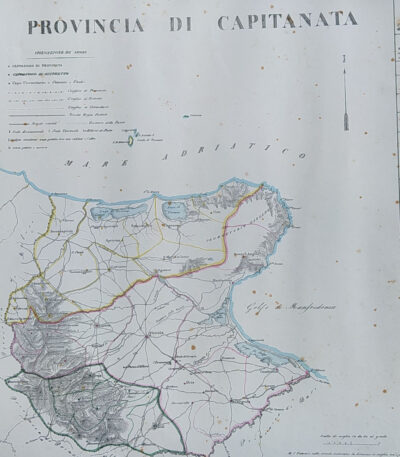
Province of Capitanata, B. Marzolla, 1832
90,00 €Province of Capitanata it is a geographical map created by B. Marzolla in 1832.
This lithograph has watercolored borders and is part of the work Historical and statistical chorographic atlas of the Kingdom of the Two Sicilies, dedicated to HM King Ferdinand II.
- Sheet size: cm. 45×60
- Technique: Lithography
- Condition: Good state of preservation
- Support: Paper
- Notes: Stains of time and light damp stains
The card will be shipped in a rigid tube via registered mail.
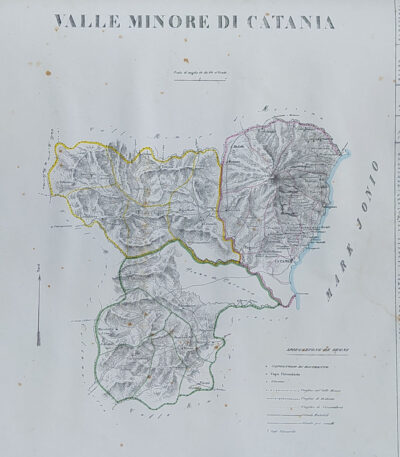
Provincia di Catania, B. Marzolla, 1832
Provincia di Catania it is a geographical map created by B. Marzolla in 1832.
This map was made in lithography with watercolor borders and is part of the work Historical and statistical chorographic atlas of the Kingdom of the Two Sicilies, dedicated to HM King Ferdinand II.
- Sheet size: cm. 45×60
- Condition: Good state of preservation
- Support: Paper
- Notes: Stains of time and light humidity stains, sheet without editorial fold
The card will be shipped in a rigid tube via registered mail.
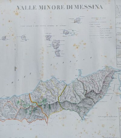
Province of Messina, B. Marzolla, 1832
Provincia di Messina It is a geographical map created by B. Marzolla in 1832, executed in lithography with watercolor borders.
This map is part of the work Historical and statistical chorographic atlas of the Kingdom of the Two Sicilies, dedicated to HM King Ferdinand II and published by the Royal Military Typography of Naples.
- Sheet size: cm. 45×60
- Condition: Good state of preservation
- Support: Paper
- Details: Stains of time and light humidity stains, sheet without editorial fold
The card will be shipped in a rigid tube via registered mail.

Provincia di Molise, B. Marzolla, 1832
90,00 €Provincia di Molise It is a geographical map created by B. Marzolla in 1832, executed in lithography with watercolor borders.
This map is part of the work Historical and statistical chorographic atlas of the Kingdom of the Two Sicilies, dedicated to HM King Ferdinand II and published by the Royal Military Typography of Naples.
- Sheet size: cm. 45×60
- Condition: Good state of preservation
- Support: Paper
- Notes: It has age stains and light humidity stains, but is free of editorial creases.
The card will be shipped in a rigid tube via registered mail.

Provincia di Napoli, B. Marzolla, 1832
Provincia di Napoli It is a geographical map created by B. Marzolla in 1832, executed in lithography with watercolor borders.
This map is taken from the work Historical and statistical chorographic atlas of the Kingdom of the Two Sicilies, dedicated to HM King Ferdinand II.
- Sheet size: cm. 45×60
- Condition: Good state of preservation
- Support: Paper
La carta presenta macchie del tempo e leggere gore di umidità, ma è priva di pieghe editoriali. Ai lati sono riportate notizie storiche e statistiche della provincia. La spedizione avverrà in tubo rigido con posta raccomandata.

Province of Syracuse, B. Marzolla, 1832
Province of Syracuse it is a geographical map created by B. Marzolla in 1832.
This lithograph has watercolored borders and is taken from the work Historical and statistical chorographic atlas of the Kingdom of the Two Sicilies, executed lithographically and dedicated to HM King Ferdinand II.
- Sheet size: cm. 45×60
- Technique: Lithography
- Condition: Good state of preservation
- Support: Paper
The paper has age stains and light humidity stains, but is free of editorial creases.
On the sides, there are historical news and statistics related to the province. The map will be shipped in a rigid tube with registered mail.
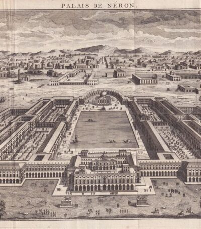
Rome, Domus Aurea, Nero's Palace, 1791
70,00 €Roma, Domus Aurea, Palazzo di Nerone è un’incisione realizzata nel 1791, che rappresenta un’importante testimonianza storica dell’architettura romana.
Questa acquaforte è parte del volume Histoire Universelle depuis les commencement du monde jusque a present, pubblicato a Parigi nel 1791.
- Sheet size: mm. 235×385 più margini irregolari di 2-3 cm
- Engraving size: mm. 235×385
- Technique: Etching
- Support: Laid paper
- Condition: Excellent general condition

Sardinia Piedmont Northern Italy map by R. Wilkinson 1808 contemporary colored
40,00 €Mappa della Sardegna, Piemonte e Italia Settentrionale, made by R. Wilkinson nel 1808, è un’incisione storica di grande interesse.
La carta, decorata con colorazione coeva, offre una rappresentazione accurata dei territori del Nord Italia e della Sardegna, con confini ben definiti e dettagli geografici rilevanti. Stampata su carta di medio spessore, presenta una piccola riparazione al margine destro, effettuata con carta al verso, senza comprometterne la qualità estetica o la leggibilità.
- Era: XIX secolo (1808)
- Technique: Incisione su rame con colorazione coeva
- Dimensions: Alla battuta del rame: 28×22 cm; intero foglio: 33×25 cm
- Support: Medium thickness paper
- Condition: Buone (riparazione al margine destro)
Questa mappa è un eccellente esempio di cartografia ottocentesca, perfetta per collezionisti e appassionati di storia geografica italiana.
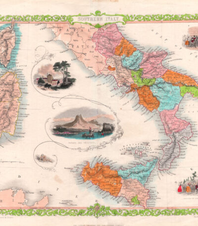
Sud Italia, Incisione di J. Rapkin, John Tallis, (1851-1860)
90,00 €Sud Italia – Incisione di J. Rapkin, pubblicata da John Tallis & Company (1851-1860)
Splendida incisione su rame acquarellata, realizzata da John Rapkin e pubblicata da John Tallis & Company tra il 1851 e il 1860. Questa mappa, “Southern Italy”, è un esempio eccezionale di cartografia decorativa del XIX secolo, caratterizzata dalla presenza di vignette illustrate che arricchiscono il valore estetico e documentario dell’opera.
Caratteristiche della mappa:
Autore: J. Rapkin
Editore: John Tallis & Company, Londra e New York
Epoca: 1851-1860
Tecnica: Incisione su rame, acquarellata
Dimensioni: cm 23 × 30 più margini
Condizione: Ottima
Descrizione dell’opera
Questa raffinata mappa del Sud Italia è accompagnata da splendide vignette incise su acciaio, che ritraggono:
Napoli, con il suo golfo e il Vesuvio sullo sfondo
Benevento, città dal grande valore storico
Una scena del Carnevale, a testimonianza delle tradizioni popolari dell’epoca
Le mappe prodotte da John Tallis e John Rapkin sono particolarmente apprezzate dai collezionisti per la ricchezza di dettagli e la qualità artistica, con elementi decorativi che comprendono paesaggi, architettura e scene di vita quotidiana.
Importanza collezionistica
Le opere di Tallis e Rapkin rappresentano uno degli ultimi esempi di cartografia decorativa, prima che la crescente precisione geografica e la necessità di mappe più tecniche portassero all’abbandono di elementi ornamentali. L’”Atlante mondiale illustrato”, di cui questa mappa fa parte, è una delle più celebri produzioni cartografiche del XIX secolo, molto ricercata per le sue incisioni dettagliate e per il fascino delle sue illustrazioni.
Un pezzo di grande valore storico, artistico e cartografico, perfetto per collezionisti di mappe antiche, appassionati di iconografia del Regno delle Due Sicilie e studiosi della cartografia ottocentesca.

Switzerland, Canton Ticino, Tyrol, 1865
60,00 €Switzerland, Canton Ticino, Tyrol It is a watercolour map made in 1865.
Drawn by Naymiller and engraved by Allodi, this map is from the Atlas of Universal Geography Chronological, Historical, Statistical and Literary by Francesco Pagnoni, published in Milan.
- Sheet size: cm. 49×38 approx.
- Map dimensions: cm. 40×32 approx.
- Technique: Watercolor
- Condition: Excellent state of preservation
- Support: Paper

Verona Theatre, Sebastian Münster, 1614
120,00 €Pagina della Cosmografia – Teatro di Verona, estratta dall’edizione tedesca della Universal Cosmography Of Sebastian Münster (1488–1552), una delle opere geografiche più influenti del Rinascimento.
Questa pagina, illustrata con una splendida xilografia, è firmata in basso a destra con il monogramma C.S., attribuito a Christoph Stimmer Johann l’Ancien (1490–1562). Tratta dall’edizione del 1588 stampata a Basilea, l’opera presenta una rappresentazione del Teatro di Verona, testimonianza dell’eccezionale perizia artistica e cartografica dell’epoca.
- Era: XVI secolo (1588)
- Technique: Xilografia su carta vergellata
- Dimensions: 30×39 cm (foglio)
- Autore della pubblicazione: Sebastian Münster
- Condition: Excellent
Questa xilografia, un raro esempio dell’arte e della cartografia rinascimentale, è ideale per collezionisti di libri antichi e appassionati di storia dell’arte e della geografia.

Land of Otranto, B. Marzolla, 1832
90,00 €Land of Otranto It is a geographical map created by B. Marzolla in 1832, executed in lithography with watercolor borders.
This map is part of the work Historical and statistical chorographic atlas of the Kingdom of the Two Sicilies, dedicated to HM King Ferdinand II and published by the Royal Military Typography of Naples.
- Sheet size: cm. 45×60
- Condition: Good state of preservation
- Support: Paper
The paper has some age stains and light humidity stains, but is free of editorial creases.
On the sides of the map there are historical information and statistics of the province. The map will be sent in a rigid tube with registered mail.

Land of Work, B. Marzolla, 1832
90,00 €Terra di Lavoro It is a geographical map created by B. Marzolla in 1832, executed in lithography with watercolor borders.
This map is part of the work Historical and statistical chorographic atlas of the Kingdom of the Two Sicilies, dedicated to HM King Ferdinand II and published by the Royal Military Typography of Naples.
- Sheet size: cm. 45×60
- Condition: Good state of preservation
- Support: Paper
The paper has some age stains and light humidity stains, but is free of editorial creases.
Ai lati della mappa sono riportate notizie storiche e statistiche relative alla provincia. La carta verrà spedita in tubo rigido con posta raccomandata.
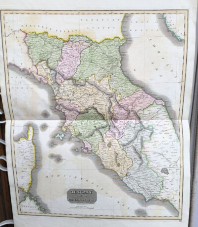
Tuscany, Central Italy, antique map Thomsons New General atlas, 1817
160,00 €Mappa della Toscana e dell’Italia Centrale, taken from Thomson’s New General Atlas, pubblicato nel 1817.
Questa grande mappa antica, caratterizzata da una colorazione coeva a mano, offre un’accurata rappresentazione della Toscana e delle regioni circostanti dell’Italia centrale. Stampata su carta pesante, si distingue per la precisione dei dettagli geografici e la qualità dell’esecuzione.
- Era: XIX secolo (1817)
- Technique: Incisione su rame con colorazione coeva
- Dimensions: Alla battuta del rame: 65×50 cm; intero foglio: 71×54 cm
- Support: Heavy paper
- Condition: Excellent
Un esempio notevole di cartografia del XIX secolo, perfetto per collezionisti e appassionati di storia geografica italiana ed europea

Urbino, St. Munster, 1614
Urbino It is a woodcut made by Sebastian Munster in 1614, taken from his famous work Cosmography Universalis.
This view of Urbino offers a fascinating representation of the city, with details that reflect the Renaissance era. On the back there is a written text that further enriches the value of this page.
- Sheet size: cm. 36×22 approx.
- Image size: cm. 8.5×13 approx.
- Support: Watercolored laid paper
- Condition: Excellent

Minor Valley of Caltanissetta, B. Marzolla, 1832
Minor Valley of Caltanissetta It is a geographical map made by Benedict Marzolla in 1832, performed in lithography with watercolor borders.
This map is part of the work Historical and statistical chorographic atlas of the Kingdom of the Two Sicilies, dedicated to HM King Ferdinand II and published by the Royal Military Typography of Naples.
- Sheet size: cm. 45×60
- Condition: Good state of preservation
- Support: Paper
- Details: It has age stains and light humidity stains, but is free of editorial creases.
On the sides of the map there are historical and statistical information about the provinces of Caltanissetta, Piazza, Terranova and Cefalù. The map will be sent in a rigid tube with registered mail.
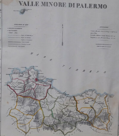
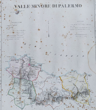
Minor Valley of Palermo, B. Marzolla, 1832
Minor Valley of Palermo It is a lithographic geographical map made by Benedict Marzolla in 1832.
This map, part of the work Historical and statistical chorographic atlas of the Kingdom of the Two Sicilies, has watercolour borders and measures 45x60 cm.
- Sheet size: cm. 45×60
- Map dimensions: cm. 45×60
- Technique: Lithography
- Condition: Good state of preservation
- Support: Paper
The paper has age stains and light humidity stains, but is free of editorial creases.
On the sides there are historical news and statistics of the provinces of Palermo, Corleone, Termini and Cefalù. The map will be sent in a rigid tube with registered mail.
Minor Valley of Palermo, B. Marzolla, 1832
Minor Valley of Palermo it is a geographical map created by B. Marzolla in 1832.
This lithograph has watercolored borders and is part of the work Historical and statistical chorographic atlas of the Kingdom of the Two Sicilies, dedicated to HM King Ferdinand II.
- Sheet size: cm. 45×60
- Paper size: Great
- Technique: Lithography
- Condition: Good state of preservation
- Support: Paper
The paper has some age stains and light humidity stains, but is free of editorial creases.
It will be shipped in a rigid tube with registered mail.

Minor Valley of Trapani, B. Marzolla, 1832
90,00 €Minor Valley of Trapani it is a geographical map created by B. Marzolla in 1832.
This map was made in lithography with watercolor borders and is part of the work Historical and statistical chorographic atlas of the Kingdom of the Two Sicilies, dedicated to HM King Ferdinand II.
- Sheet size: cm. 45×60
- Condition: Good state of preservation
- Support: Paper
The paper has some age stains and light humidity stains, but is free of editorial creases.
On the sides of the map there are historical information and statistics of the province. The map will be sent in a rigid tube with registered mail.
