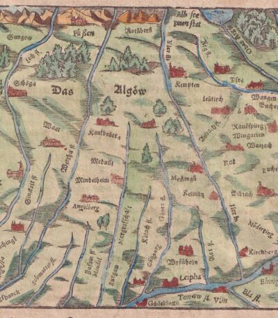
Algoia, St.Munster, 1614
Algoia, St.Munster, 1614 it's a view of Bavaria Algow, located in Germany, taken from the famous work Cosmography Universalis by Sebastian Munster.
This woodcut is an important cartographic testimony of the 17th century, made on watercolour laid paper.
- Sheet size: cm. 36×22 approx.
- Image size: cm. 12.5×15 approx.
- Support: Laid paper
- Condition: Excellent
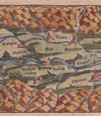
Alsace, St.Munster, 1614
Alsace, St. Munster It is a woodcut extracted from the Cosmography Universalis by Sebastian Munster, published in Basel in 1614.
This map represents Alsace, specifically the region of Lower Alsace, with the city of Speir in Germany.
- Sheet size: cm. 36×22 approx.
- Image size: cm. 9×13 approx.
- Support: Watercolored laid paper
- Condition: Excellent state of preservation

South America, CF Delamarche, 1816
70,00 €South America It is a map engraved by CF Delamarche in 1816, representing South America.
This copper engraving is colored around the outline and is taken from the volume Petit Atlas Moderne ou Collection de Cartes Elementaires, dedicated to youth and published in Paris by Delamarche.
- Sheet size: cm. 21×27 approx.
- Condition: Good condition, with some peeling and a central editorial crease
- Support: Paper

North America, CF Delamarche, 1816
70,00 €North America It is a copper engraving map colored around the outline, made by CF Delamarche in 1816.
This map is part of the volume Petit Atlas Moderne ou Collection de Cartes Elementaires, published in Paris by Delamarche.
- Sheet size: cm. 21×27 approx.
- Condition: Good condition, with some peeling and a central editorial crease
- Support: Paper

Andromeda del Tempio delle Muse del 1676, xilografia 1882
30,00 €Rappresentazione delle costellazioni, taken from Les Étoiles et les Curiosités du Ciel Of Camille Flammarion, pubblicato a Parigi nel 1882.
Questa affascinante stampa xilografica illustra una rappresentazione antica delle costellazioni, accompagnata da testo descrittivo. L’incisione è parte di una pagina originale del celebre trattato astronomico di Flammarion, autore noto per la sua opera di divulgazione scientifica. La pagina ha testo intorno all’immagine e sul verso.
- Era: 19th century
- Technique: Woodcut
- Page size: Medie (cm 25×16 circa)
- Support: Paper
- Condition: Good
- Characteristics: La stampa verrà spedita nella pagina intera originale
Un’interessante testimonianza della tradizione astronomica ottocentesca, ideale per collezionisti e appassionati di storia dell’astronomia.

Andromeda Perseo Cassiopea, 1882
30,00 €Rappresentazione delle costellazioni, taken from Les Étoiles et les Curiosités du Ciel Of Camille Flammarion, pubblicato a Parigi nel 1882.
Questa affascinante stampa xilografica illustra una rappresentazione antica delle costellazioni, accompagnata da testo descrittivo. L’incisione è parte di una pagina originale del celebre trattato astronomico di Flammarion, autore noto per la sua opera di divulgazione scientifica. La pagina ha testo intorno all’immagine e sul verso.
- Era: 19th century
- Technique: Woodcut
- Dimensions: Medie (cm 25×16 circa)
- Support: Paper
- Condition: Good
- Characteristics: La stampa verrà spedita nella pagina intera originale
Un’interessante testimonianza della tradizione astronomica ottocentesca, ideale per collezionisti e appassionati di storia dell’astronomia.

Antiche costellazioni da una stampa del 1559, xilografia 1882
30,00 €Rappresentazione delle costellazioni, taken from Les Étoiles et les Curiosités du Ciel Of Camille Flammarion, pubblicato a Parigi nel 1882.
Questa affascinante stampa xilografica illustra una rappresentazione antica delle costellazioni, accompagnata da testo descrittivo. L’incisione è parte di una pagina originale del celebre trattato astronomico di Flammarion, autore noto per la sua opera di divulgazione scientifica. La pagina ha testo intorno all’immagine e sul verso.
- Era: 19th century
- Technique: Woodcut
- Dimensions: Medie (cm 25×16 circa)
- Support: Paper
- Condition: Good
- Characteristics: La stampa verrà spedita nella pagina intera originale
Un’interessante testimonianza della tradizione astronomica ottocentesca, ideale per collezionisti e appassionati di storia dell’astronomia.
Aachen, St.Munster, 1614
Aachen, St.Munster, 1614 it's a view of the city of Hachen Aachen, also known as Aken or Aix-la-Chapelle, taken from the famous work Cosmography Universalis by Sebastian Munster.
This woodcut, made on watercolour laid paper, offers a fascinating representation of the city in 1614. On the back there is a writing that adds further historical value to the work.
- Sheet size: cm. 36×22 approx.
- Image size: cm. 12.5x15.5 approx.
- Support: Watercolored laid paper
- Condition: Excellent state of preservation

Asia, Otto Petri, 1853
50,00 €Asia è una mappa incisa e colorata a mano realizzata da Otto Petri nel 1853.
This work comes from the School Atlas Alle Deelen Der Aarde, published by J. Van Den Bosch in Rotterdam.
- Sheet size: cm. 26×34 approx.
- Map dimensions: cm. 22×27 approx.
- Support: Medium thickness paper
- Condition: Excellent state of preservation
- Characteristics: White back, editorial fold
Austria, St.Munster, 1614
Austria, St.Munster, 1614 It is an Osterzeich map, taken from the famous Cosmography Universalis by Sebastian Munster.
This map, made in 1614, offers a detailed representation of the Austrian region, with a written back that adds historical value to the work.
- Sheet size: cm. 36×22 approx.
- Image size: cm. 9×13,5 approx.
- Support: Watercolored laid paper
- Condition: Excellent

Bay, Pozzuoli, Christopher Weigel, 1719
Bay, Pozzuoli It is an engraving made by Christopher Weigel In the 1719, which represents the famous town of Pozzuoli in Campania.
This work is an example of an original copper engraving, with beautiful colouring contemporary with the watercolour, which enhances the details.
- Sheet size: cm. 37,5×28,5 approx.
- Support: Laid paper with watermark
- Condition: Good condition, with some stains on the front and back and a thin, almost invisible lesion at the bottom

Bavaria, St.Munster, 1614
Bavaria, St.Munster, 1614 è una veduta affascinante della Baviera, estratta dalla celebre Cosmography Universalis by Sebastian Munster.
Questa xilografia, realizzata su carta vergellata acquarellata, offre uno sguardo dettagliato sulla regione nel 1614. Sul retro, sono presenti altre immagini che arricchiscono ulteriormente l’opera.
- Sheet size: cm. 36×22 approx.
- Image size: cm. 7×13 approx.
- Support: Watercolored laid paper
- Condition: Excellent

Belgium, St.Munster, 1614
Belgium, St.Munster, 1614 It is a fascinating view of the province of Brabant in Belgium, taken from the famous Cosmography Universalis by Sebastian Munster.
This woodcut, made on watercolour laid paper, offers an important geographical and historical testimony of the 17th century.
- Sheet size: cm. 36×22 approx.
- Image size: cm. 9×13,5 approx.
- Support: Watercolored laid paper
- Condition: Excellent state of preservation

Benelux, Otto Petri, 1853
50,00 €Benelux è una mappa incisa a mano da Eight Petri In the 1853, che rappresenta i paesi del Benelux: Olanda, Lussemburgo e Belgio.
Questa incisione colorata è parte del School Atlas Alle Deelen Der Aarde, published by J. Van Den Bosch in Rotterdam.
- Sheet size: cm. 26×34 approx.
- Map dimensions: cm. 22×27 approx.
- Support: Medium thickness paper
- Condition: Excellent condition

Brunswick, St. Munster, 1614
Brunswick, St. Munster, 1614 is a historical view of the city of Braunschweig, located in Lower Saxony, Germany.
This engraving is taken from the famous work Cosmography Universalis by Sebastian Munster, published in Basel in 1614.
- Sheet size: cm. 36×22 approx.
- Engraving size: cm. 12.5×15 approx.
- Support: Laid paper
- Condition: Excellent state of preservation

Campidonia, St.Munster, 1614
Campidonia, St.Munster it's a view of Kempten, Germany, made by Sebastian Munster in 1614. This engraving is extracted from the Cosmography Universalis, a fundamental work for the cartography of the period.
The engraving is monogrammed at the bottom left with the initials GS Of Gregorius Sickinger (1558-1631). On the back there is a writing that adds further historical value to the work.
- Sheet size: cm. 36×22 approx.
- Engraving size: cm. 12×15 approx.
- Support: Watercolored laid paper
- Condition: Excellent state of preservation

Map of the Netherlands, Holland and Belgium 1824 by L. Vivien watercolour lithograph
60,00 €Carta dei Paesi Bassi: Olanda e Belgio è una mappa geografica realizzata nel 1824, progettata da L. Vivien e incisa da Giraldon-Bovinet.
Questa opera, pubblicata a Parigi, rappresenta con precisione i territori del Regno dei Paesi Bassi, comprendendo le attuali regioni di Olanda e Belgio. La mappa è impreziosita da una colorazione a mano che ne esalta i dettagli geografici e artistici.
- Era: 19th century
- Technique: Watercolor lithograph
- Dimensions: Grandi (29×39 cm, più margini)
- Support: Strong paper
- Condition: Excellent
Questa stampa è ideale per collezionisti o appassionati di mappe storiche e offre una testimonianza preziosa del periodo post-napoleonico in Europa.

Map of Africa l. Vivien 1826
60,00 €Carte Generale de l’Afrique è una raffinata mappa geografica realizzata nel 1826 dal cartografo L. Vivien and engraved by Giraldon-Bovinet. Pubblicata a Parigi, questa mappa offre una rappresentazione dettagliata del continente africano, arricchita da un’acquarellatura d’epoca.
L’opera riflette il periodo storico in cui le esplorazioni e i primi studi geografici moderni sull’Africa erano in pieno sviluppo, rendendola un prezioso esempio di cartografia del XIX secolo.
- Era: 19th century
- Technique: Watercolor lithograph
- Dimensions: Grandi (cm 29×39 più margini)
- Support: Strong paper
- Condition: Buone (piccole spellature e mancanze, ma nel complesso ben conservata)
Questa mappa è ideale per collezionisti di stampe antiche e appassionati di storia cartografica.

Cellarius, Belgium, 1701
60,00 €Cellarius, Belgium, 1701 è una mappa incisione su rame realizzata da Christophorus Cellarius, tratta dal suo lavoro Notitia Orbis Antiqui sive Geographia Plenior.
Questa mappa rappresenta la Gallia Belgica ed è un’importante testimonianza cartografica del XVII secolo.
- Sheet size: cm. 24×33 approx.
- Engraving size: cm. 20×30 approx.
- Support: Paper
- Condition: Excellent

Cellarius, France, 1701
60,00 €Cellarius It is a copper engraving map made in France in 1701, taken from the work Notitia Orbis Antiqui sive Geographia Plenior by Christophorus Cellarius.
This engraving offers a detailed representation of Gaul, highlighting the geographical features of the time.
- Sheet size: cm. 24×33 approx.
- Engraving size: cm. 20×30 approx.
- Support: Paper
- Condition: Excellent state of preservation

Cellarius, Germany, 1701
60,00 €Cellarius, Germany, 1701 It is a copper engraving representing a detailed map, taken from Notitia Orbis Antiqui sive Geographia Plenior by Christophorus Cellarius, published in 1701.
This work offers a fascinating insight into the geography of the period, making it a valuable piece for collectors and history buffs.
- Sheet size: cm. 24×33 approx.
- Engraving size: cm. 20×30 approx.
- Support: Paper
- Condition: Excellent state of preservation

Cellarius, Great Britain, 1701
60,00 €Insularum Britannicarum Facies Antiqua It is a copper-engraved map made by Christophorus Cellarius in 1701, from his work Notitia Orbis Antiqui sive Geographia Plenior.
This engraving provides a detailed representation of the British Isles, reflecting the geography of the period.
- Sheet size: cm. 24×33 approx.
- Engraving size: cm. 20×30 approx.
- Support: Paper
- Condition: Excellent state of preservation

Cellarius, Greece, 1701
60,00 €Cellarius, Grecia è una mappa incisa su rame realizzata nel 1701 da Christophorus Cellarius.
This engraving is taken from the work Notitia Orbis Antiqui sive Geographia Plenior, pubblicata nel 1701.
- Sheet size: cm. 24×33 approx.
- Engraving size: cm. 20×30 approx.
- Support: Paper
- Condition: Excellent
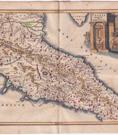
Cellarius, Central Italy, 1701
150,00 €Cellarius, Central Italy, 1701 it is a valuable one carta dell’Italia Centrale, realizzata attraverso un’incisione su rame dal Cellario.
This work is taken from Notitia Orbis Antiqui sive Geographia Plenior by Christophorus Cellarius, published in 1701.
- Sheet size: cm. 24×33 approx.
- Engraving size: cm. 20×30 approx.
- Support: Paper
- Condition: Excellent
Si tratta di una rara rappresentazione, caratterizzata da un’ottima coloritura, che rende questa incisione un pezzo da collezione molto ricercato.
