Filter by price
Filter by technique
- Woodcut (52)
- Etching (13)
- Other (2)
- Burin (84)
- Chromolithography (2)
- Lithography (16)
Product categories
- Allegories 25
- Anatomy Medicine 187
- Animals Zoology 163
- Old Masters 1234
- Famous Old Masters 637
- Berchem Nicolaes 35
- Callot Jacques 31
- Of the Beautiful Stephen 94
- David Deuchar 169
- Dore Gustave 103
- Dürer Albrecht 19
- Gabriel Perelle 24
- Hogarth William 87
- Salvator Rosa 21
- Van Ostade Adriaen 83
- Ancient Italian Masters 366
- Ancient Foreign Masters 823
- Famous Old Masters 637
- Architecture 41
- Arts and Crafts 406
- 20th Century Artists 16
- Astrology 59
- Astronomy 25
- Children 89
- Bartholomew Pinelli 123
- Botany Flowers Fruit 118
- Cartography 412
- Consalvo Carelli 31
- Costumes 547
- Drawings and Watercolors 130
- Ex libris 232
- Falsi d'Autore 3
- Butterflies 22
- Games 16
- Joseph Maria Mitelli 40
- Central Italy 960
- Insular Italy 274
- Southern Italy 898
- Avellino 9
- Bari 9
- Barletta 5
- Benevento 12
- Toasts 13
- Phlegraean Fields 83
- Campobasso 10
- Capri 18
- Caserta 43
- Catanzaro 4
- Chieti 8
- Cosenza 7
- Croton 2
- Foggia 15
- Ischia 20
- Isernia 3
- The Eagle 25
- Lecce 13
- Matera 3
- Naples 453
- Naples Province 63
- Pompei 49
- Power 9
- Reggio Calabria 16
- Salerno 74
- Sorrento 25
- Taranto 4
- Teramo 7
- Vesuvius 25
- Northern Italy 1028
- Alexandria 67
- Aosta 36
- Asti 9
- Belluno 9
- Bergamo 12
- connecting rod 3
- Bologna 37
- Bolzano 15
- Brescia 21
- How 31
- Cremona 16
- Wedge 43
- Ferrara 24
- ForliCesena 3
- Genoa 70
- Imperia 19
- La_Spezia 12
- Lecco 6
- Praise 3
- Mantua 23
- Milan 53
- Modena 16
- Monza 3
- New 9
- Padua 27
- Parma 15
- Pavia 27
- Pleasure 10
- Ravenna 23
- Reggio Emilia 9
- Rimini 4
- Rovigo 4
- San_Marino 2
- Savona 10
- Sondrio 18
- Turin 76
- Trento 25
- Treviso 13
- Trieste 21
- Udine 8
- Varese 8
- Venice 94
- Verbano Ossola 16
- Vercelli 10
- Verona 48
- Vicenza 27
- Ancient Books 55
- Ancient Maps 249
- Masks 45
- Ovid's Metamorphoses 65
- Military Battles 82
- Mythology 110
- Fashion 39
- Monarchy 96
- Monograms Numbers 221
- Music 37
- Famous People 588
- Saints 212
- Ancient Holy Cards 250
- Holy cards 20th century 57
- Genre Scenes 409
- Science and Technology 59
- Watercolor Prints 63
- Antique Prints for Events and Weddings 17
- Prints with Marine Ships 12
- Prints with Nudes 23
- Prints from Paintings 447
- Decorative Prints 626
- Large Format Prints 181
- Religion Prints 728
- Erotic Prints 110
- Small Size Prints 160
- Prints cm7x10 31
- Prints cm8x11 75
- Prints cm9x12 54
- Coats of arms 116
- History and Culture 983
- Universal Cosmography 119
- Dance of Death 97
- Philosophy 9
- Literature 142
- History and Culture 371
- Natural history 441
- Theater 43
- Birds 174
- Humor Satire 43
- Views of Foreign Cities 447
- Africa 3
- Albania 3
- America 1
- Australia 2
- Austria 17
- Belgium 9
- Bulgaria 1
- Canada 1
- China 4
- Croazia 2
- Denmark 2
- Egypt 6
- France 70
- Germany 75
- Greece 47
- India 2
- England 20
- Israel 7
- Lebanon 2
- Malta 11
- Netherlands 2
- Paris 14
- Poland 2
- Portugal 8
- Repubblica Ceca 2
- Russia 12
- Syria 2
- Spain 41
- United States 6
- Swiss 51
- Tunisia 6
- Türkiye 15
- Italian City Views 2919
Map of Austria. Hungary, Bohemia, Bavaria, 18th century cm 35×50
60,00 €Mappa dell’Austria, Ungheria, Boemia, Piccola Polonia, Carinzia e Baviera è un’incisione storica di fine XVIII secolo, realizzata su carta spessa e decorata con colorazione al contorno dei confini.
La mappa presenta una dettagliata rappresentazione delle regioni dell’Europa centrale, evidenziando i confini politici e geografici dell’epoca. Grazie alla precisione tecnica e alla qualità della colorazione, quest’opera costituisce un’importante testimonianza cartografica del periodo, ideale per collezionisti e studiosi.
- Era: XVIII secolo (fine)
- Technique: Incisione su rame con colorazione al contorno
- Dimensions: Grandi (35×50 cm)
- Support: Thick paper
- Condition: Excellent
Questa mappa offre una visione unica dell’Europa centrale settecentesca, rappresentando un elemento di grande valore storico e artistico.
Map of Bavaria, St.Munster, 1614
Map of Bavaria It is an engraving made by Sebastian Munster in 1614, extracted from his famous work Cosmography Universalis.
This map depicts the Schwabenland region in detail, highlighting significant places such as the Danube and Nordlingen.
- Sheet size: cm. 35×44 approx.
- Image size: cm. 26×34 approx.
- Support: Watercolored laid paper
- Condition: Excellent state of preservation
Map of Europe 1869
60,00 €Map of Europe 1869 it is a valuable one chromolithography representing the European continent in a detailed format.
This map is taken from the work Hand – Und Schulatlas uber alle Theile Der Erde, published in 1869.
- Sheet size: mm. 437×347
- Support: Strong paper
- Condition: Excellent condition
- Notes: White back, editorial fold
Map of Europe, 1869
60,00 €Map of Europe It is a watercolour lithograph from 1869, made on strong paper.
This map, part of the volume Hand – Und Schulatlas uber alle Theile Der Erde, presents a sheet size of mm. 437×347 and a white back with editorial fold.
- Condition: Excellent condition
- Support: Strong paper
Map of France, 1614
Map of France It is a page extracted from the Cosmography Universalis by Sebastian Munster, published in Basel in 1614.
This map represents Gaul and includes the coat of arms of France, dating back to the 16th century. On the back there is a writing that adds further historical value to the work.
- Sheet size: cm. 36×22 approx.
- Image size: cm. 8×13 approx.
- Support: Watercolored laid paper
- Condition: Excellent state of preservation
Map of France, 1869
60,00 €Map of France It is a watercolour lithograph made in 1869, which offers a detailed representation of the French territory.
This map is taken from the volume Hand – Und Schulatlas über alle Teile Der Erde, and is characterized by an editorial fold.
- Sheet size: mm. 437×347
- Support: Strong paper
- Condition: Excellent condition
- Back: White
Map of Germany, 1869
60,00 €Map of Germany è una litografia acquarellata del 1869, che rappresenta in modo dettagliato il territorio tedesco.
This map is taken from the volume Hand – Und Schulatlas uber alle Theile Der Erde, and is characterized by an editorial fold.
- Sheet size: mm. 437×347
- Support: Strong paper
- Condition: Excellent condition
- Back: White
Map of Germany, 1869
60,00 €Map of Germany It is a watercolour lithograph made in 1869, which offers a detailed representation of the German territory.
This map is taken from the volume Hand – Und Schulatlas über alle Teile Der Erde, a reference work of the time.
- Sheet size: mm. 437×347
- Support: Strong paper
- Condition: Excellent condition
- Characteristics: White back, editorial fold
Map of Germany, 1869
60,00 €Map of Germany it is a precious one chromolithography built in 1869.
This map, part of the volume Hand – Und Schulatlas uber alle Theile Der Erde, features accurate details and vivid coloring.
- Sheet size: mm. 437×347
- Condition: Excellent
- Support: Strong paper, white back
- Characteristics: Editorial fold
Map of Great Britain, 1869
60,00 €Map of Great Britain It is a watercolour lithograph made in 1869, which represents England, Scotland and Ireland in detail.
This map is taken from the volume Hand – Und Schulatlas uber alle Theile Der Erde and is presented with an editorial twist.
- Sheet size: mm. 437×347
- Support: Strong paper
- Condition: Excellent condition
- Back: White
Map of Prussia, Austria, 1821
25,00 €Mappa della Prussia, Austria It is a small geographical map made in 1821.
Questa incisione in rame è stata acquarellata e presenta dimensioni di cm. 9×9 about on a sheet of cm. 13×15.
- Back: White
- Taken from: French text from 1821
- Condition: Excellent condition
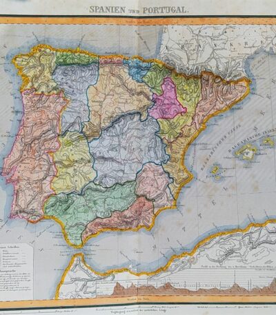
Map of Spain and Portugal, 1869
60,00 €Map of Spain and Portugal It is a watercolour lithograph from 1869, which represents the Iberian territories in detail.
This map is taken from the volume Hand – Und Schulatlas uber alle Theile Der Erde and is presented with an editorial twist.
- Sheet size: mm. 437×347
- Support: Strong paper
- Condition: Excellent condition
Mappa della Spagna, stemmi di Aragona, Granata, dalla Cosmografia di S.Munster del 1614
Mappa della Spagna con al retro stemmi delle principali città della Spagna. Pagina estratta dalla Cosmography Universalis by Sebastian Munster, published in Basel in 1614.
Questa mappa, datata 1614, offre una rappresentazione dettagliata della Spagna, con stemmi di Aragona, Granada, Portogallo, Castiglia, Leon, Toledo, Galizia e Navarra, tutti colorati ad acquarello sul retro.
- Sheet size: cm. 36×22 approx.
- Image size: cm. 8×13 approx.
- Support: Laid paper
- Condition: Excellent state of preservation
Map of Sweden, Russia, Germany, Poland and Denmark, 1760
40,00 €A new and compleat map of the parts of Sweden, Russia, Germany, Poland and Denmark, bordering on the Baltick Sea è una mappa storica pubblicata nel 1760 da J. Hinton a Newgate Street, Londra.
L’opera raffigura con dettagliata precisione le regioni che circondano il Mar Baltico, includendo Svezia, Russia, Germania, Polonia e Danimarca, e rappresenta un esempio significativo della cartografia settecentesca britannica, realizzata in un periodo di crescente interesse per l’espansione geografica e politica.
- Era: 18th century
- Technique: Copper engraving
- Dimensions: Grandi (28×34 cm, senza margini)
- Support: Paper
- Condition: Buone (nota: assenza della cornice laterale)
Questa mappa è un’importante testimonianza storica che combina arte e scienza, rappresentando un’opportunità preziosa per collezionisti e studiosi di cartografia.
Map of Türkiye, 1821
25,00 €Map of Türkiye, 1821 It is a small geographical map representing Turkey in Europe, made in 1821.
This copper engraving has been watercoloured and has a white backing.
- Sheet size: cm. 13×15 approx.
- Map dimensions: cm. 9×9 approx.
- Support: Paper
- Condition: Excellent
Map of Türkiye, Asia, 1821
25,00 €Map of Türkiye, Asia It is a watercolour copper engraving dating back to 1821.
This small geographical map measures approximately 9x9 cm on a sheet of 13x15 cm.
- Back: White
- Taken from: French text from 1821
- Condition: Excellent condition
Map of Flanders, 1614
Map of Flanders it is a precious engraving made by Sebastian Munster in 1614, taken from his famous work Cosmography Universalis.
This map features Flanders, a historical region of Belgium, and is notable for its detailed geographical representation.
- Sheet size: cm. 36×22 approx.
- Image size: cm. 11,5×15 approx.
- Support: Watercolored laid paper
- Condition: Excellent state of preservation
Map of the islands of America, 1821
25,00 €Mappa delle isole dell’America è un’incisione in rame acquarellata realizzata nel 1821.
Questa piccola carta geografica, di dimensioni contenute, offre una rappresentazione dettagliata delle isole americane, ed è tratta da un testo francese dell’epoca.
- Sheet size: cm. 13×15 approx.
- Engraving size: cm. 9×9 approx.
- Support: Paper
- Condition: Excellent state of preservation
Map of Cales, 1614
Map of Cales It is a page extracted from the Cosmography Universalis, created by Sebastian Munster in 1614.
This view of Cales, located in France, was colored in watercolor, while the reverse features a view of the city of Artois.
- Sheet size: cm. 36×22 approx.
- Image size: cm. 12×15,5 approx.
- Support: Laid paper
- Condition: Excellent state of preservation
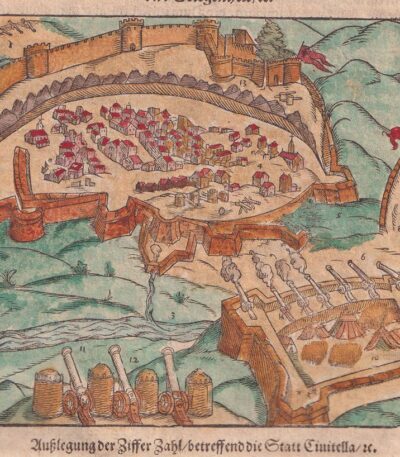
Map of Civitella, Abruzzi, 1614
Map of Civitella, Abruzzi It is a woodcut made by Sebastian Munster in 1614, taken from his famous work Cosmography Universalis.
This view represents Civitella del Tronto, located in the province of Teramo, in Abruzzo. On the back there is another image.
- Sheet size: cm. 36×22 approx.
- Image size: cm. 12.5x15.5 approx.
- Support: Watercolored laid paper
- Condition: Excellent state of preservation
Map of Estampes, 1614
Map of Estampes it is a valuable woodcut made by Sebastian Munster in 1614, taken from his famous work Cosmography Universalis.
This map provides a detailed view of the city of Estampes (Etampes) in France, highlighting the geographical and historical importance of the region.
- Sheet size: cm. 36×22 approx.
- Image size: cm. 10×18 approx.
- Support: Watercolored laid paper
- Condition: Excellent state of preservation
Map of Gravelines, France, 1614
Map of Gravelines, France it is a valuable engraving made by Sebastian Munster in 1614, taken from his famous work Cosmography Universalis.
This map offers a detailed view of Gravelines (Gravelingen), coloured in watercolour, with a view of Sancerra on the reverse.
- Sheet size: cm. 36×22 approx.
- Image size: cm. 12×15,5 approx.
- Support: Watercolored laid paper
- Condition: Excellent state of preservation
Map of Haarlem, 1614
Mappa di Haarlem it is a precious engraving made by Sebastian Munster in 1614, taken from his famous work Cosmography Universalis.
Questa mappa colorata rappresenta la città di Haarlem, situata nei Paesi Bassi, e offre una visione dettagliata della sua geografia e architettura. Il retro della mappa presenta scritte che ne attestano l’autenticità e la provenienza.
- Sheet size: cm. 36×22 approx.
- Image size: cm. 8×13 approx.
- Support: Watercolored laid paper
- Condition: Excellent state of preservation
Mappa di Perpignan, Francia, da Cosmografia di S.Munster, 1614
Map of Perpignan, France It is a woodcut made by Sebastian Munster in 1614, taken from his work Cosmography Universalis.
This map features the historic city of Perpignan, capital of the Pyrénées-Orientales department and once capital of the County of Roussillon.
- Sheet size: cm. 36×22 approx.
- Image size: cm. 12.5x15.5 approx.
- Support: Laid paper
- Condition: Excellent state of preservation
Explore the fascinating world of antique prints
Antique prints are silent witnesses of history, capable of transporting us to distant eras through the art of engraving. Our e-commerce offers a vast selection of these precious finds, carefully selected for their authenticity and artistic value. Whether you are an expert collector or a novice enthusiast, you will find unique pieces here that will enrich your spaces with a touch of timeless elegance.
A safe and rewarding shopping experience
We understand the importance of each individual print and are committed to ensuring a flawless purchasing experience. Our secure payment system and insured shipping with professional packaging ensure that each piece arrives in the best condition. Our expertise in the sector allows us to offer detailed descriptions and personalized advice, helping you to make informed choices. If you have any questions or specific requests, do not hesitate to contact us: we will be happy to guide you into the wonderful world of antique prints.