
Paper

Mantua, Panoramic View, 1859
40,00 €Mantua, Panoramic View It is a woodcut made in 1859, which offers a bird's eye view of the historic city of Mantua.
This work is taken from the volume Wars of Italy and features writing on the verso, making it an interesting piece for collectors and history buffs.
- Sheet size: cm. 22×32 approx.
- Support: Paper
- Condition: Excellent
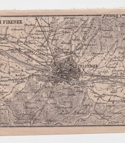
Mappa dei dintorni di Firenze, 1873
25,00 €Mappa dei dintorni di Firenze It is a copper engraving made in 1873.
This map is taken from the Guide in Italy, edited by Cav. PE Sacchi and published by the Artaria company of Milan.
Sul retro è presente un’area bianca, mentre a lato si trova la legenda dei siti più importanti della città.
- Sheet size: cm. 15.5x9.5 approx.
- Condition: Excellent condition
- Support: Paper
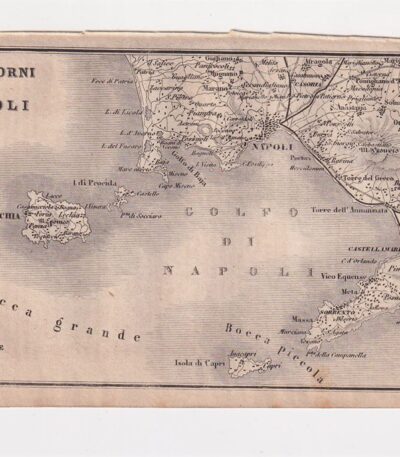
Mappa dei dintorni di Napoli, 1873
25,00 €Mappa dei dintorni di Napoli è un’incisione su rame realizzata nel 1873, che rappresenta la città di Napoli e l’Italia meridionale.
This map is taken from the publication Guide in Italy, curata dal cav. P.E. Sacchi e stampata dalla ditta Artaria di Milano.
- Sheet size: cm. 15.5x9.5 approx.
- Support: Paper
- Condition: Excellent condition
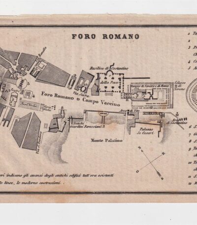
Map of the Roman Forum, 1873
25,00 €Map of the Roman Forum It is a copper engraving made in 1873.
This map, taken from the Guide in Italy edited by Cav. PE Sacchi and published by the Artaria company of Milan, offers a detailed representation of the Roman Forum.
- Sheet size: cm. 15.5x9.5 approx.
- Support: Paper
- Condition: Excellent state of preservation
- Characteristics: White back with legend of the most important sites of the city

Map of North America, 1869
60,00 €Mappa del Nordamerica It is a watercolour lithograph from 1869, made on strong paper.
This map, part of the work Hand – Und Schulatlas uber alle Theile Der Erde, presenta un retro bianco e una piega editoriale.
- Sheet size: mm. 437×347
- Condition: Excellent
- Support: Strong paper

Map of South America, 1869
60,00 €Mappa del Sudamerica è una litografia acquarellata realizzata nel 1869.
This map, part of the volume Hand – Und Schulatlas uber alle Theile Der Erde, presents a sheet size of mm. 437×347 and a white back.
- Sheet size: Great
- Technique: Lithography
- Condition: Excellent
- Support: Strong paper
- Characteristics: Editorial fold

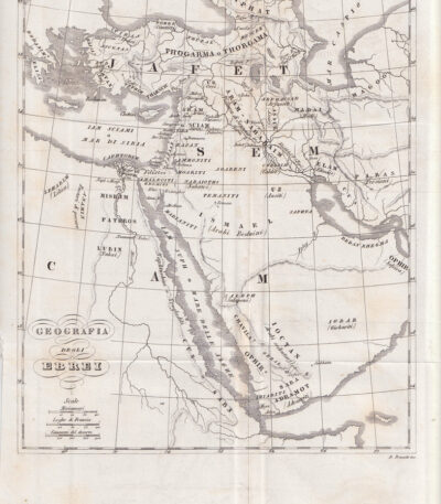
Map of Egypt, 1821
25,00 €Map of Egypt It is a small geographical map made in 1821.
This copper engraving was hand-watercoloured and measures approximately 9 x 9 cm, on a sheet of 13 x 15 cm.
- Back: White
- Taken from: French text from 1821
- Condition: Excellent condition

Mappa dell’ Europa, 1869
60,00 €Mappa dell’Europa, 1869 è una litografia colorata all’acquarello che rappresenta una visione dettagliata del continente europeo.
This map, part of the Hand und Schulatlas di Dr. V.F. Klun, è stata pubblicata nel 1869 e si distingue per la sua precisione e bellezza.
- Map dimensions: cm. 34×28 circa
- Sheet size: cm. 44×35 circa
- Support: Strong paper
- Condition: Excellent condition
Mappa dell’Egitto, 1846
30,00 €Map of Egypt è un’incisione in rame realizzata nel 1846, che rappresenta non solo l’Egitto, ma anche la Siria, Israele, Giordania, Turchia e Arabia Saudita.
This map is taken from the Storia Universale di Cesare Cantù, pubblicata a Torino presso gli Editori Giuseppe Pomba & C.
- Sheet size: cm. 20×24 approx.
- Technique: Burin
- Condition: Buone condizioni, con varie pieghe editoriali
- Support: Paper
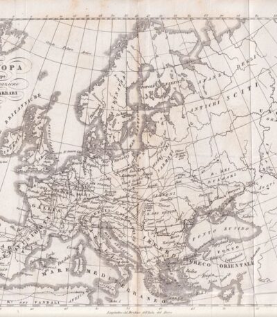
Mappa dell’Europa, 1846
30,00 €Mappa dell’Europa, 1846 è un’incisione in rame che rappresenta l’Europa dopo la migrazione dei Barbari.
This map is taken from the Storia Universale di Cesare Cantù, pubblicata a Torino presso gli Editori Giuseppe Pomba & C nel 1846.
- Sheet size: cm. 20×24 approx.
- Condition: Buone condizioni, con varie pieghe editoriali
- Support: Paper

Mappa dell’Europa, 1846
40,00 €Mappa dell’Europa, 1846 è un’incisione in rame che rappresenta l’Europa al tempo delle Crociate.
This map is taken from the Storia Universale di Cesare Cantù, pubblicata a Torino presso gli Editori Giuseppe Pomba & C nel 1846.
- Sheet size: cm. 20×24 approx.
- Technique: Burin
- Condition: Buone condizioni, con varie pieghe editoriali
- Support: Paper
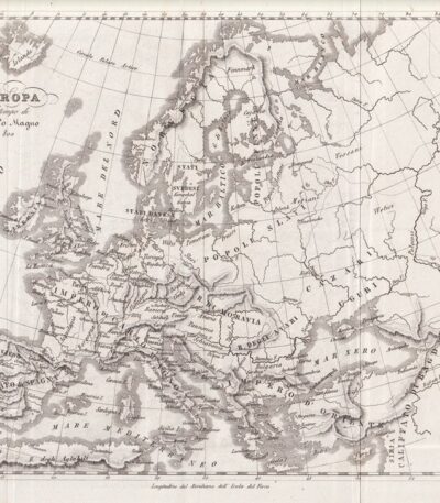
Mappa dell’Europa, 1846
30,00 €Mappa dell’Europa è un’incisione in rame realizzata nel 1846, che rappresenta l’Europa al tempo di Carlo Magno.
This map is taken from the Storia Universale di Cesare Cantù, pubblicata a Torino presso gli Editori Giuseppe Pomba & C.
- Sheet size: cm. 20×24 approx.
- Technique: Burin
- Condition: Good
- Support: Paper

Mappa dell’Europa, 1846
30,00 €Mappa dell’Europa, 1846 è un’incisione in rame che rappresenta l’Europa alla caduta dell’Impero d’Oriente.
This map is taken from the Storia Universale di Cesare Cantù, pubblicata a Torino presso gli Editori Giuseppe Pomba & C. nel 1846.
- Sheet size: cm. 20×24 approx.
- Technique: Burin
- Condition: Good condition
- Support: Paper
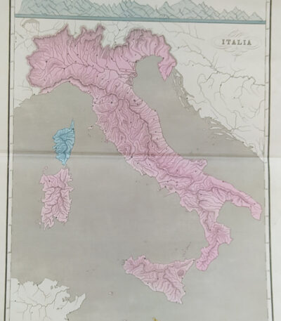
Mappa dell’Italia, 1865
60,00 €Mappa dell’Italia, realizzata nel 1865, è una carta geografica di grande interesse storico.
Drawn by Naymiller and engraved by Allodi, this map is from theAtlas of Universal Geography Chronological, Historical, Statistical and Literary by Francesco Pagnoni, published in Milan in 1865.
- Sheet size: cm. 49×38 approx.
- Map dimensions: cm. 40×32 approx.
- Support: Paper
- Condition: Buona conservazione
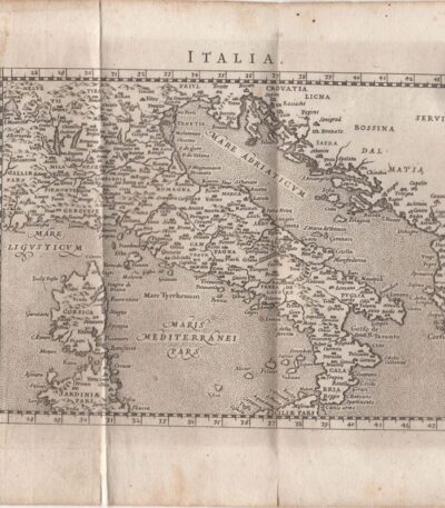
Map of Italy, Scotus, 1761
120,00 €Mappa dell’Italia it is a copper engraving made by Francesco Scotto in 1761.
This map is taken from the work Itinerary of Italy, published in Rome at the expense of Fausto Amidei, Book Merchant.
- Sheet size: cm. 18×23 approx.
- Engraving size: cm. 12×18 approx.
- Support: Laid paper
- Condition: Excellent state of preservation
- Folds: Editorials
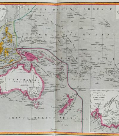
Mappa dell’Oceania, 1865
60,00 €Mappa dell’Oceania è una carta geografica acquarellata realizzata nel 1865.
Drawn by Naymiller and engraved by Allodi, this map is from theAtlas of Universal Geography Chronological, Historical, Statistical and Literary by Francesco Pagnoni, published in Milan.
- Sheet size: cm. 49×38 approx.
- Map dimensions: cm. 40×32 approx.
- Support: Paper
- Condition: Excellent

Map of Africa, 1869
60,00 €Map of Africa It is a watercolour lithograph made in 1869.
This map, part of the volume Hand – Und Schulatlas uber alle Theile Der Erde, has a sheet size of 437x347 mm.
- Sheet size: mm. 437×347
- Technique: Watercolor lithograph
- Support: Strong paper
- Condition: Excellent condition
- Back: White
- Special features: Editorial fold

Map of Asia, 1821
25,00 €Mappa della Asia It is a watercolour copper engraving dating back to 1821.
Questa piccola carta geografica, di dimensioni cm. 9×9 circa, è stampata su un foglio di cm. 13×15 e presenta un retro bianco.
Tratta da un testo francese dell’epoca, si presenta in excellent condition.
- Sheet size: cm. 13×15 approx.
- Engraving size: cm. 9×9 approx.
- Support: Paper
- Condition: Excellent
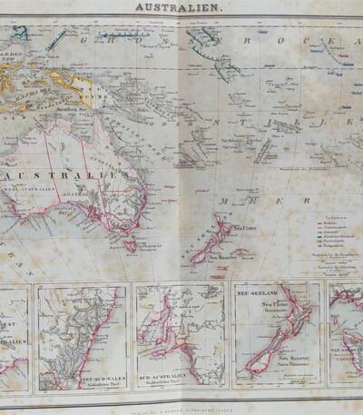
Map of Australia, 1869
60,00 €Mappa della Australia è una litografia acquarellata del 1869, che offre una rappresentazione dettagliata del continente australiano.
This map is taken from the volume Hand – Und Schulatlas uber alle Theile Der Erde e presenta un retro bianco con una piega editoriale.
- Sheet size: mm. 437×347
- Technique: Lithography
- Condition: Excellent
- Support: Strong paper
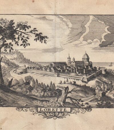
Map of the city of Loreto, 1712
60,00 €Loreto City Map it is an engraving made by P. Mortier in 1712.
This map is an etching on copper, taken from the work The delights of Italy, German edition by De Rogissart, published in Berlin in 1712.
- Sheet size: cm. 16×19 approx.
- Engraving size: cm. 11×15 approx.
- Support: Light laid paper
- Condition: Excellent state of preservation
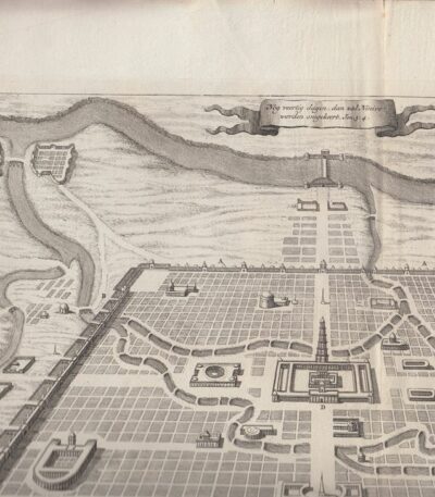
Mappa della città di Ninive, 1650 ca
40,00 €Mappa della città di Ninive è un’incisione realizzata da Diodoro Siculo, datata circa 1650.
Questa mappa rappresenta la città di Ninive secondo le descrizioni di Diodoro Siculo e del famoso erudito E.P. Kircherus.
- Sheet size: cm. 46×38 circa
- Engraving size: cm. 43×30 approx.
- Technique: Etching
- Support: Carta spessa vergellata senza filigrana
- Condition: Excellent condition

Map of Denmark, 1821
25,00 €Map of Denmark It is a watercolour copper engraving dating back to 1821.
This small, moderately sized map is taken from a French text of the time.
- Sheet size: cm. 13×15 approx.
- Map dimensions: cm. 9×9 approx.
- Support: Paper
- Condition: Excellent condition

Map of Europe 1869
60,00 €Map of Europe 1869 it is a valuable one chromolithography representing the European continent in a detailed format.
This map is taken from the work Hand – Und Schulatlas uber alle Theile Der Erde, published in 1869.
- Sheet size: mm. 437×347
- Support: Strong paper
- Condition: Excellent condition
- Notes: White back, editorial fold
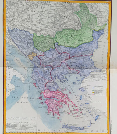
Map of Eastern Europe, 1869
60,00 €Map of Eastern Europe It is a watercolour lithograph made in 1869, which represents Turkey, Bulgaria, Bosnia and Greece.
This map is taken from the volume Hand – Und Schulatlas über alle Teile Der Erde and is characterized by an editorial fold.
- Sheet size: mm. 437×347
- Support: Strong paper
- Condition: Excellent condition
- Back: White
