
Paper
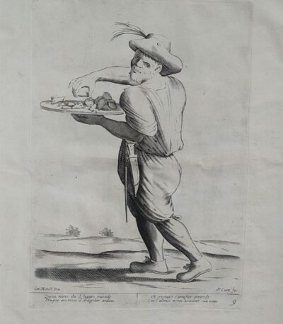
Mitelli Giuseppe Maria, Arts and Crafts on the Street, Seller of Liver Offal, 1660
120,00 €Arti e Mestieri per la via, Venditore di frattaglie di fegato It is a work created by Joseph Maria Mitelli In the 1660, inspired by the works of Hannibal Carracci.
Questa acquaforte presenta una misura dell’immagine di cm. 27×19 alla battuta del rame, su un supporto di carta vergellata spessa che misura cm. 43×31.
L’opera è firmata in basso a sinistra con CM. Mitelli Inv. e a destra con F. Curti fe.. Sotto la linea marginale si trovano quattro righe in versi che descrivono il mestiere rappresentato.
- Era: XVII
- Technique: Etching
- Condition: Good
- Dimensions: Great
- Support: Paper

Mitelli Giuseppe Maria, Arts and Crafts on the Street, Seller of Ribbons, Pins, Needles, 1660
120,00 €Arts and Crafts on the Street It is an engraving made by Joseph Maria Mitelli In the 1660, ispirata ai temi del commercio e dell’artigianato.
Quest’opera, che rappresenta un Venditore di nastri, spille e aghi, è una delle illustrazioni tratte da THE ARTS BY WAY DRAWN, AND OFFERED TO THE GREAT AND TALL GIANT NEPTUNE MR. OF THE BOLOGNA SQUARE.
- Sheet size: cm. 43×31 approx.
- Engraving size: cm. 27×19 approx.
- Support: Thick laid paper
- Condition: Good condition
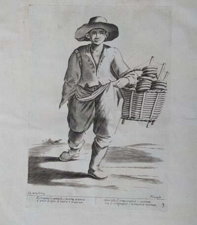
Mitelli Giuseppe Maria, Arti e Mestieri per la via, Venditore di pere e mele cotte, 1660
120,00 €Arti e Mestieri per la via, Venditore di pere e mele cotte It is an engraving made by Joseph Maria Mitelli In the 1660, ispirata ai temi della vita quotidiana.
Questa opera è un esempio significativo del lavoro di Mitelli, noto per le sue rappresentazioni vivaci e dettagliate delle professioni del suo tempo.
- Sheet size: cm. 43×31 approx.
- Engraving size: cm. 27×19 approx.
- Technique: Etching
- Support: Thick laid paper
- Condition: Good condition
Al di sotto della linea marginale, l’opera presenta quattro righe in versi sul mestiere rappresentato, rendendola non solo un’opera d’arte ma anche un documento culturale.
Bibliography: The engravings of Giuseppe Maria Mitelli: critical catalogue, p. 50, 1940.
Mitelli Giuseppe Maria, Arti e Mestieri per la via, Venditore di rosari e immagini sacre, 1660
120,00 €Arts and Crafts on the Street It is an engraving made by Joseph Maria Mitelli nel 1660, ispirata ai mestieri tradizionali dell’epoca.
This work, which measures cm. 27×19 alla battuta del rame, è stampata su carta vergellata spessa in size cm. 43×31.
- Technique: Etching
- Condition: Good
- Signed: CM. Mitelli Inv. e F.Curti fe.
- Verses: Quattro righe in versi sul mestiere rappresentato
This work is part of the series THE ARTS BY WAY DRAWN, AND OFFERED […] TO THE GREAT AND TALL GIANT NEPTUNE MR. OF THE BOLOGNA SQUARE.
Bibliography: The engravings of Giuseppe Maria Mitelli: critical catalogue, p. 50, 1940.
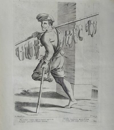
Mitelli Giuseppe Maria, Arti e Mestieri per la via, Venditore di scarpe, 1660
120,00 €Arti e Mestieri per la via, Venditore di scarpe It is an engraving made by Joseph Maria Mitelli In the 1660, ispirata ai mestieri rappresentati da Hannibal Carracci.
This work is part of the series L’Arti per via disegnate, et offerte al grande et alto Nettuno gigante, ed è firmata in basso a sinistra con ‘CM. Mitelli Inv.’ e a destra ‘F. Curti fe’.
- Sheet size: cm. 43×31 approx.
- Engraving size: cm. 27×19 approx.
- Technique: Etching
- Support: Thick laid paper
- Condition: Good condition
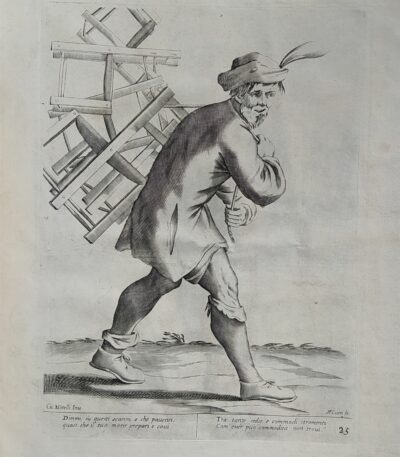
Mitelli Giuseppe Maria, Arts and Crafts on the Street, Chair Seller, 1660
120,00 €Arti e Mestieri per la via, Venditore di sedie It is an engraving made by Joseph Maria Mitelli In the 1660, ispirata ai temi degli artigiani e dei mestieri.
This work is part of the series L’Arti per via disegnate, et offerte al grande et alto Nettuno gigante, un omaggio alla tradizione bolognese.
- Sheet size: cm. 43×31 approx.
- Engraving size: cm. 27×19 approx.
- Support: Thick laid paper
- Condition: Good condition
Mitelli Giuseppe Maria, Arti e Mestieri per la via, Venditore di sterco di polli, 1660
120,00 €Arti e Mestieri per la via, Venditore di sterco di polli It is an engraving made by Joseph Maria Mitelli In the 1660, ispirata ai mestieri rappresentati da Hannibal Carracci.
This work is part of the series L’Arti per Via Disegnate, e presenta un’immagine di cm. 27×19 alla battuta del rame, su carta vergellata spessa di cm. 43×31.
- Sheet size: cm. 43×31 approx.
- Engraving size: cm. 27×19 approx.
- Support: Laid paper
- Condition: Good condition
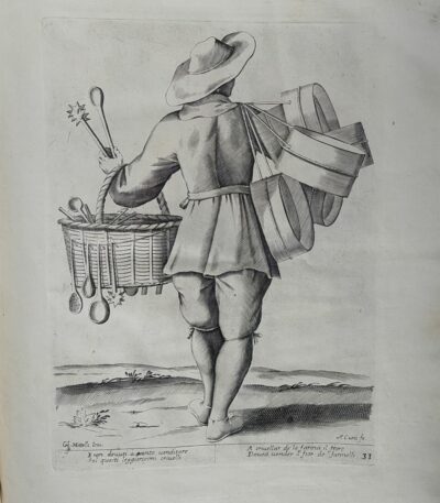
Mitelli Giuseppe Maria, Arti e Mestieri per la via, Venditore di stoviglie di vetro, 1660
120,00 €Arti e Mestieri per la via, Venditore di stoviglie di vetro It is an engraving made by Joseph Maria Mitelli In the 1660, ispirata ai temi della vita quotidiana e delle professioni.
This work is part of the series THE ARTS BY WAY DRAWN, AND OFFERED […] TO THE GREAT AND TALL GIANT NEPTUNE MR. OF THE BOLOGNA SQUARE, e presenta un’accurata rappresentazione del venditore di stoviglie di vetro.
- Sheet size: cm. 43×31 approx.
- Engraving size: cm. 27×19 approx.
- Technique: Etching
- Support: Thick laid paper
- Condition: Good condition
Mitelli Giuseppe Maria, Arti e Mestieri per la via, Venditore di trippa, Tripparolo, 1660
120,00 €Venditore di trippa It is an engraving made by Joseph Maria Mitelli nel 1660, parte della serie Arts and Crafts on the Street.
Questa opera, che rappresenta un tipico mestiere bolognese, è caratterizzata da un’immagine di cm. 27×19, impressa su carta vergellata spessa di cm. 43×31.
- Sheet size: cm. 43×31 approx.
- Engraving size: cm. 27×19 approx.
- Technique: Etching
- Support: Laid paper
- Condition: Good condition
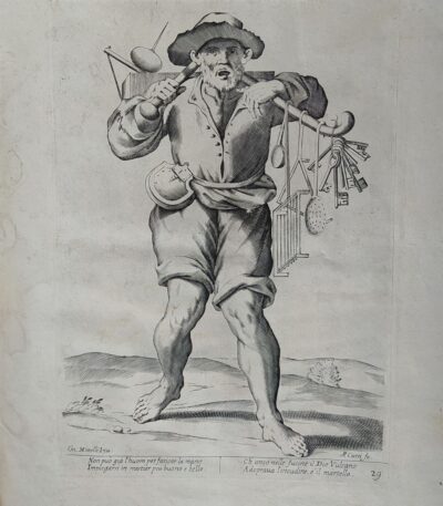
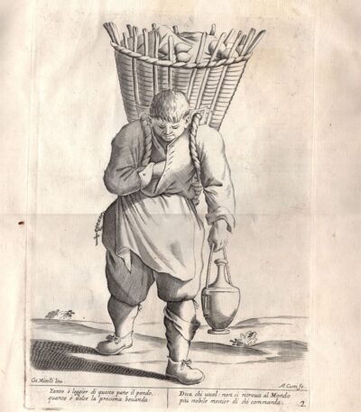
Mitelli Giuseppe Maria, Arti e Mestieri per la via, Venditore di utensili da cucina, 1660
120,00 €Arts and Crafts on the Street It is an engraving made by Joseph Maria Mitelli In the 1660, ispirata ai mestieri rappresentati nella vita quotidiana.
Questa opera è un esempio della sua abilità nell’acquaforte, con una misura dell’immagine di cm. 27×19 alla battuta del rame, su un supporto di carta vergellata spessa che misura cm. 43×31.
The engraving is signed lower left with CM. Mitelli Inv. and to the right F.Curti does. Sotto la linea marginale, si trovano quattro righe in versi che descrivono il mestiere rappresentato.
- Sheet size: cm. 43×31 approx.
- Engraving size: cm. 27×19 approx.
- Support: Laid paper
- Condition: Good condition
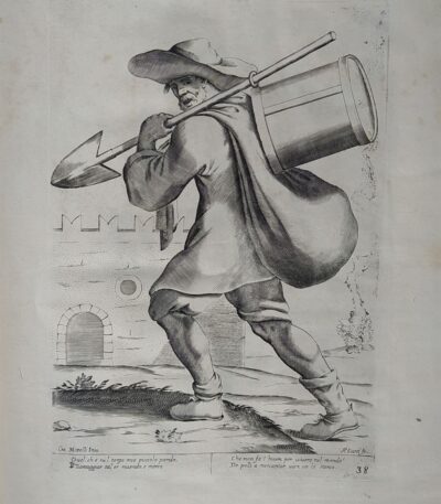
Mitelli Giuseppe Maria, Arts and Crafts on the Street, Iron Tool Seller, 1660
120,00 €Arts and Crafts on the Street It is an engraving made by Joseph Maria Mitelli In the 1660, ispirata ai mestieri rappresentati da Annibale Carracci.
This work is an example of etching and measure 27×19 cm alla battuta del rame, su un foglio di carta vergellata spessa di 43×31 cm.
Firmata in basso a sinistra con ‘CM. Mitelli Inv.’ e a destra ‘F.Curti fe’, l’incisione presenta anche quattro righe in versi sul mestiere rappresentato.
- Sheet size: cm. 43×31 approx.
- Engraving size: cm. 27×19 approx.
- Support: Laid paper
- Condition: Good condition
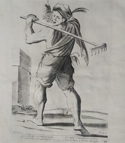
Mitelli Giuseppe Maria, Arti e Mestieri per la via, Venditore di uva, Vignaiolo, 1660
120,00 €Arti e Mestieri per la via – Venditore di uva, Vignaiolo It is an engraving made by Joseph Maria Mitelli nel 1660, ispirata ai mestieri rappresentati da Hannibal Carracci.
This work is an etching that measures cm. 27×19 alla battuta del rame, su un foglio di carta vergellata spessa che misura cm. 43×31.
Firmata in basso a sinistra con CM. Mitelli Inv. and to the right F.Curti does, l’incisione presenta anche quattro righe in versi sul mestiere rappresentato, situate al di sotto della linea marginale.
- Sheet size: cm. 43×31
- Engraving size: cm. 27×19
- Technique: Etching
- Condition: Good
- Support: Laid paper
Mitelli Giuseppe Maria, Arti e Mestieri per la via, Venditore di vasellame di terracotta, 1660
120,00 €Arts and Crafts on the Street It is an engraving made by Joseph Maria Mitelli nel 1660, ispirata ai lavori di Hannibal Carracci.
Questa opera rappresenta un venditore di vasellame di terracotta ed è parte della serie L’Arti per via disegnate, et offerte al Grande et Alto Nettuno Gigante, dedicata alla piazza di Bologna.
- Sheet size: cm. 43×31 approx.
- Engraving size: cm. 27×19 approx.
- Technique: Etching
- Support: Thick laid paper
- Condition: Good condition
Al di sotto della linea marginale, si trovano quattro righe in versi sul mestiere rappresentato.
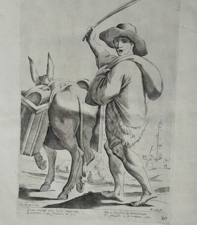
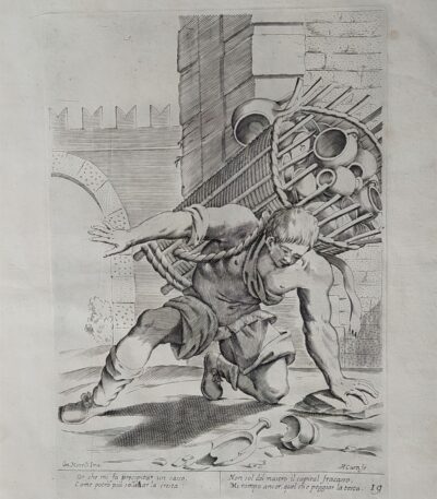
Mitelli Giuseppe Maria, Arti e Mestieri per la via, Venditore di vasi con asino, 1660
120,00 €Arti e Mestieri per la via, Venditore di vasi con asino It is an engraving made by Joseph Maria Mitelli In the 1660.
Questa opera, che fa parte della serie L’Arti per via disegnate, et offerte al grande et alto Nettuno gigante, è un esempio significativo dell’arte bolognese del XVII secolo.
- Sheet size: cm. 43×31 approx.
- Engraving size: cm. 27×19 approx.
- Technique: Etching
- Support: Thick laid paper
- Condition: Good condition
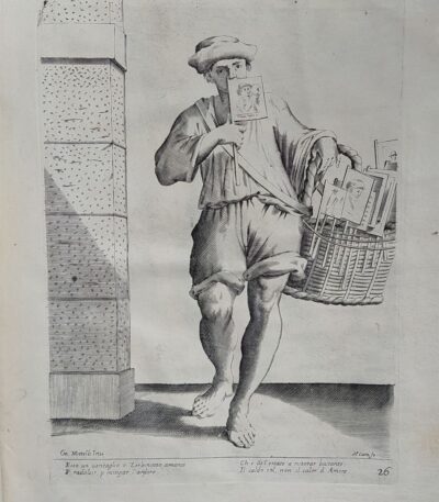
Mitelli Giuseppe Maria, Arti e Mestieri per la via, Venditore di ventagli, 1660
120,00 €Arti e Mestieri per la via, Venditore di ventagli It is an engraving made by Joseph Maria Mitelli In the 1660, ispirata ai mestieri rappresentati da Hannibal Carracci.
This work is part of the series L’Arti per via disegnate, et offerte al grande et alto Nettuno gigante sig. della piazza di Bologna.
- Sheet size: cm. 43×31 approx.
- Engraving size: cm. 27×19 approx.
- Technique: Etching
- Support: Thick laid paper
- Condition: Good condition
Al di sotto della linea marginale, sono presenti quattro righe in versi sul mestiere rappresentato.

Mitelli Giuseppe Maria, Arti e Mestieri, Agricoltore del Grano, 1660
120,00 €Arti e Mestieri, Agricoltore del Grano It is an engraving made by Joseph Maria Mitelli In the 1660.
This work is part of the series L’Arti per via disegnate, et offerte al grande et alto Nettuno gigante, dedicata alla rappresentazione delle professioni.
- Sheet size: cm. 43×31 approx.
- Image size: cm. 27×19 approx.
- Technique: Etching
- Support: Thick laid paper
- Condition: Buone (strappo riparato al verso)
The engraving is signed lower left with CM. Mitelli Inv. and to the right F. Curti does. Al di sotto della linea marginale, sono presenti quattro righe in versi che descrivono il mestiere rappresentato.
Mitelli Giuseppe Maria, Arti e Mestieri, per la via, Venditore di ciambelle 1660
120,00 €Venditore di ciambelle It is an engraving made by Joseph Maria Mitelli nel 1660, parte della serie Arts and Crafts on the Street.
Questa opera, che rappresenta un venditore di ciambelle, è un esempio significativo dell’arte bolognese del XVII secolo.
- Sheet size: cm. 43×31 approx.
- Engraving size: cm. 27×19 approx.
- Technique: Etching
- Support: Thick laid paper
- Condition: Good condition
Mitelli Giuseppe Maria, Arti e Mestieri, per la via, Venditore di pane 1660
120,00 €Arti e Mestieri, Venditore di pane It is an engraving made by Joseph Maria Mitelli In the 1660.
This work, part of the series L’Arti per Via Disegnate, è un esempio significativo dell’arte bolognese del XVII secolo.
- Sheet size: cm. 43×31 approx.
- Engraving size: cm. 27×19 approx.
- Technique: Etching
- Support: Thick laid paper
- Condition: Good condition
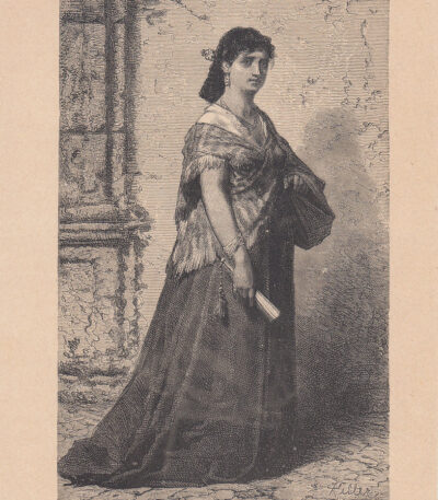
Roman Model, 1885
20,00 €Roman Model it is a woodcut made in 1885, measuring 18x12 cm, with small margins.
This work is taken from the volume Italy Pictorial Journey from the Alps to Etna, written by G. Stieler, E. Paulus and W. Kaden, published in Milan by Fratelli Treves, Editori.
- Engraving size: cm. 18×12 approx.
- Support: Paper
- Condition: Excellent condition
- Notes: The print has been cut from the book page and will be shipped complete with mat, ready to receive the frame.
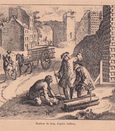
Modellatore del legno, xilografia dell’800
25,00 €Modellatore del legno è un’incisione in xilografia risalente alla fine dell’800.
Questa affascinante opera è tratta da un testo dell’epoca e presenta un’illustrazione dettagliata del processo di modellazione del legno.
- Sheet size: cm. 27×18 approx.
- Engraving size: cm. 15×11 approx.
- Support: Paper
- Condition: Excellent
La stampa verrà spedita nella sua interezza, estratta dal libro originale, con testo attorno e al verso.
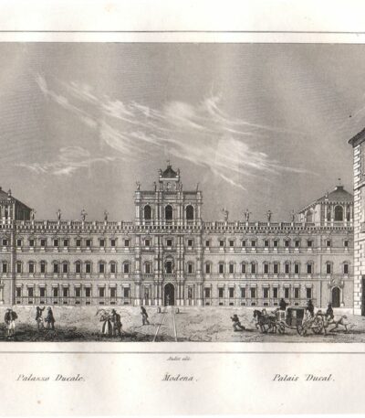
Modena, 1835, Ducal Palace
25,00 €Modena, Palazzo Ducale è un’incisione in rame realizzata nel 1835 da Pierre Eugene Aubert, un noto incisore e disegnatore francese.
Questa veduta panoramica rappresenta la piazza e il palazzo, offrendo un’immagine animata e decorativa della città di Modena.
- Sheet size: cm. 150×100 più margini
- Technique: Burin
- Condition: Excellent
- Support: Paper

Modena, 1850
40,00 €Modena, 1850 è un’incisione realizzata in acquaforte, che rappresenta una splendida veduta della città.
This work is taken from the volume The Classic Lands of Europe, Italy, Sicily and Greece.. di John Sherer, pubblicato dalla London Printing and Publishing Company nel 1850.
- Engraving size: cm. 13×18,5
- Sheet size: cm. 22×32
- Support: Strong paper
- Condition: Perfect
L’incisione presenta dettagli nitidi e un’animazione che cattura l’essenza di Modena nel XIX secolo.
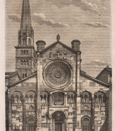
Modena, Cathedral, 1865
15,00 €Modena, Duomo It is a woodcut made in 1865, coming from the Chorographic Dictionary of Italy by Prof. Amato Amati.
This work is illustrated with about 1000 colored municipal weapons and was published by Vallardi Editore in Milan.
- Sheet size: mm. 140×220
- Technique: Woodcut
- Condition: Good
- Support: Paper
Please note that the print has been cut from the book and has writing on the back.

Modena, Cathedral, 1890
30,00 €Modena, Duomo è una xilografia realizzata nel 1890, che rappresenta la facciata del Duomo di Modena e la Torre della Ghirlandaia.
Questa stampa è tratta da un testo italiano di fine Ottocento e presenta un testo attorno e al verso del foglio.
- Sheet size: cm. 30×20 approx.
- Image size: cm. 17×14 approx.
- Support: Paper
- Condition: Excellent
