
Paper

Carnello, 1842
20,00 €Carnello, 1842 It is a lithograph that offers a view of the woollen cloth factory of the Zino family, located in Carnello, together with the adjacent Church of S. Restituta, overlooking the banks of the Fibreno.
This work was created by R. Carelli and taken from the volume Picturesque Polyorama, published in Naples in 1842.
- Sheet size: mm. 160×230
- Condition: Excellent
- Support: Paper
- Notes: Almost no margins; the print has writing on the back.
This is a beautiful, uncommon view, perfect for art and history lovers.
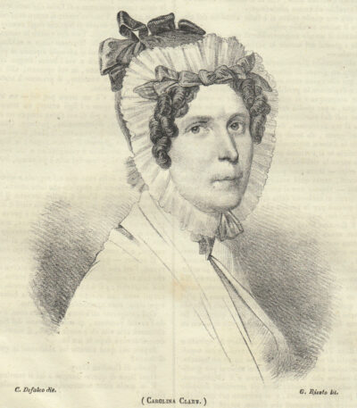
Carolina Clary, 1844
15,00 €Carolina Clary è una litografia realizzata nel 1844, tratta dal famoso periodico Picturesque Polyorama of Naples.
Questa opera ritrae Carolina Clary, moglie di Tommaso Clary, generale del Regno di Napoli.
- Sheet size: cm. 15×18 approx.
- Support: Light paper
- Condition: Excellent condition
- Back: Printed
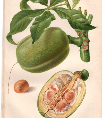
Carolinea macrocarpa, 1887
30,00 €Carolinea macrocarpa it's a chromolithography made in 1887.
This work is taken from the Horticultural Review di Parigi ed è stata realizzata da Godard e litografata da G. Severeyns.
- Sheet size: cm. 25×16
- Support: Thick paper, white back
- Condition: Excellent condition
Splendida stampa, molto decorativa e di grande impatto visivo.

Charon, Ary Scheffer, 1856
20,00 €Charon It is a woodblock woodcut made by Ary Scheffer In the 1856.
This work represents the passage through the Styx towards the city of You say, inspired by theHell of Dante.
- Size of the joke: mm. 220×170
- Margins: Almost absent
- Support: Paper
- Condition: Good
The print was cut from the book The Illustrated London News and has writing on the back.

Carpi, Town Hall, 1890
20,00 €Carpi, Palazzo Comunale It is a woodcut made in 1890 by the engraver A. Quantin.
Questa stampa è tratta da un libro francese di fine ‘800 e presenta un’illustrazione vivace e dettagliata.
- Sheet size: cm. 10×13
- Technique: Woodcut
- Condition: Excellent
- Support: Paper
The print was cut from the book and has writing on the back.
Verrà spedita la pagina intera contenente la stampa, garantendo così la conservazione del contesto originale.

Carpi, Vittorio Emanuele Square, 1890
20,00 €Carpi, Piazza Vittorio Emanuele it's a woodblock print realizzata nel 1890, che rappresenta un’importante testimonianza visiva della fine dell’Ottocento.
This work is characterized by a large-sized image cm. 9×12 approximately, surrounded by text and with further information on the back of the sheet, which measures cm. 30×20.
- Sheet size: cm. 30×20 approx.
- Image size: cm. 9×12 approx.
- Support: Paper
- Condition: Excellent

Carrara, 1877
15,00 €Carrara, 1877 It is a woodcut made by Adolf Closs, which represents a fountain in Carrara.
This work is taken from L'Italy illustrée de 450 engravures sur wood, published in Paris by Hachette in 1877.
- Sheet size: mm. 130×200
- Support: Light paper
- Condition: Good condition, with almost no margins and writing on the back
Carrara, Marble Quarry, 1885
30,00 €Carrara, Marble Quarry It is an 1885 engraving depicting a view of the famous Carrara marble quarry.
Made in woodcut, the work was drawn by Pieter Francis Peters and engraved by Octave Edouard Jean Jahyer.
- Sheet size: cm. 27×37 approx.
- Engraving size: cm. 19×25 approx.
- Support: Light paper
- Condition: Excellent state of preservation
This engraving is taken from the volume Italy Pictorial Journey from the Alps to Etna, published in Milan by the Treves Brothers.
Pieter Francis Peters, a renowned Dutch landscape artist, and Octave Edouard Jean Jahyer, a Parisian engraver, collaborated to create this fascinating depiction of Italy's natural beauty.

Carrara, Coat of Arms, 1871
15,00 €Carrara, Coat of Arms It is a woodcut made in 1871, taken from the work The Hundred Cities of Italy for Ariodante Manfredi.
This print features an engraving measuring 8x9 cm, with small margins, on a light sheet.
- Sheet size: Small
- Condition: Excellent
- Support: Paper

Roman carter, 1840
45,00 €Carrettiere Romano è un’acquaforte acquarellata realizzata nel 1840, tratta dall’opera Costumi di Roma e suoi contorni, disegnata da vari artisti e incisa da Salvatore Marroni.
Questa pregevole opera è stata pubblicata a Roma presso l’editore e calcografo Tommaso Cuccioni, situato in Via della Croce N.88.
- Sheet size: cm. 32×22 approx.
- Support: Medium thickness paper with white backing
- Condition: Excellent
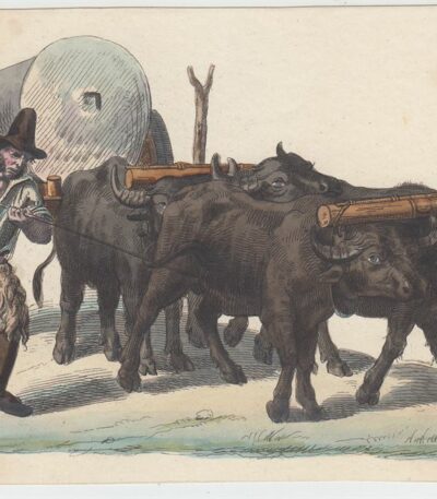
Ox Cart, Watercolor Etching, 19th Century
20,00 €Ox cart it is an engraving made in watercolour etching in 19th century.
This anonymous work depicts a man transporting an ox-drawn cart, a theme that evokes rural life at the time.
- Sheet size: cm. 21×15 approx.
- Condition: Excellent state of preservation
- Support: Medium thickness paper
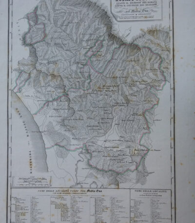
Map of the Duchy of Lucca, 1842
90,00 €Map of the Duchy of Lucca It is an engraving made in 1842, which represents the territory of Lucca during Roman rule and in the Middle Ages.
This work is a physical, historical and statistical chorography of Italy and its islands, created by Attilio Zuccagni-Orlandini.
- Sheet size: cm. 45×62
- Engraving size: cm. 45×62
- Support: Thick engraving paper
- Condition: Perfect state of preservation
- Technique: Etching finished with a burin
This detailed map offers a historical overview of the city of Lucca and its surroundings.

Map of the Port of Syracuse, 1889
20,00 €Map of the Port of Syracuse it's a woodblock print made in 1889.
This work is taken from the volume Naples and Sicily by Jules Gourdault, published in Paris by Libraire Hachette.
- Sheet size: cm. 12×14 approx.
- Condition: Excellent
- Support: Paper
The print was cut from the book and features a printed back.

Map of Northern Italy, 1834
30,00 €Carta dell’ Italia Settentrionale è un’incisione realizzata da Th. Duvotenay nel 1834.
Questa mappa, che rappresenta la parte settentrionale dell’Italia, è stata incisa in rame a Parigi.
- Engraving size: mm. 232×182
- Margins: almost absent
- Support: Lightweight paper, white back
- Condition: Excellent condition
Si tratta di una bella e decorativa carta dell’Italia Settentrionale, perfetta per collezionisti e appassionati di cartografia.

Map of Northern Italy, 1836
40,00 €Map of Northern Italy è un’incisione in rame realizzata da Th. Duvotenay nel 1836.
Questa carta, parte delle carte routiere de l’Italie, è una rappresentazione dettagliata e decorativa dell’Italia Settentrionale.
- Sheet size: cm. 55×37 circa
- Engraving size: cm. 47×29 circa
- Support: Lightweight paper, white back
- Condition: Excellent

Map of the Barbarian invasion in Europe, 1865
60,00 €Carta dell’invasione dei Barbari in Europa è una mappa storica realizzata nel 1865, disegnata da Naymiller e incisa da Allodi.
Questa carta colorata offre una rappresentazione dettagliata degli eventi storici legati all’invasione dei Barbari in Europa, ed è parte dell’opera Atlas of Universal Geography Chronological, Historical, Statistical and Literary di Francesco Pagnoni.
- Sheet size: cm. 49 x 38 circa
- Paper size: cm. 40 x 32 circa
- Support: Paper
- Condition: Excellent

Map of the Province of Alessandria, 1890
20,00 €Carta della Provincia di Alessandria It is a woodcut print made in 1890 by the engraver Barberis.
Questa opera è un esempio di arte grafica italiana di fine Ottocento, caratterizzata da un’accurata rappresentazione cartografica.
- Sheet size: cm. 14×19 circa
- Support: Retro bianco
- Condition: Excellent
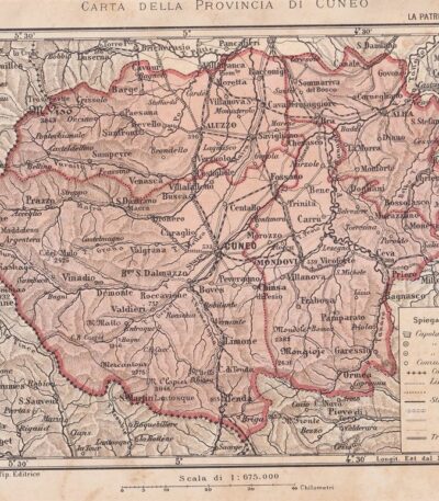
Map of the Province of Cuneo, 1890
30,00 €Carta della Provincia di Cuneo è una litografia realizzata nel 1890, rappresentante una mappa dettagliata della provincia.
Questa stampa è tratta da un testo italiano di fine Ottocento, stampata dalla litografia Salussolia.
- Sheet size: cm. 14×19 circa
- Support: Paper
- Condition: Excellent
The entire sheet containing the print will be shipped.

Geographical Map of Piedmont, 1890
30,00 €Carta Geografica del Piemonte it is a woodcut print made in 1890, coming from an Italian text from the late nineteenth century.
Questa mappa offre una rappresentazione dettagliata della regione piemontese, con testo informativo al verso del foglio.
- Sheet size: cm. 30×20 approx.
- Image size: cm. 23×17 approx.
- Support: Paper
- Condition: Excellent

Carta Geografica dell’Umbria, 1890
30,00 €Carta Geografica dell’Umbria è una pregevole stampa xilografica realizzata nel 1890, proveniente da un testo italiano di fine Ottocento.
Questa carta offre una rappresentazione dettagliata della regione umbra, con testo al verso del foglio.
- Sheet size: cm. 30×20 approx.
- Image size: cm. 23×16 approx.
- Technique: Woodcut
- Condition: Excellent
- Support: Paper

Carta Geografica della Basilicata, 1890
30,00 €Carta Geografica della Basilicata it is a woodcut print made in 1890, coming from an Italian text from the late nineteenth century.
Questa carta offre una rappresentazione dettagliata della regione, con testo esplicativo attorno e sul retro del foglio.
- Sheet size: cm. 30×20 approx.
- Image size: cm. 24×17 approx.
- Technique: Woodcut
- Condition: Excellent
- Support: Paper

Carta Geografica della Calabria, 1890
30,00 €Carta Geografica della Calabria it is a woodcut print made in 1890, coming from an Italian text from the late nineteenth century.
Questa carta offre una rappresentazione dettagliata della regione calabrese, con testo descrittivo attorno e al verso del foglio.
- Sheet size: cm. 30×20 approx.
- Image size: cm. 17×24 approx.
- Support: Paper
- Condition: Excellent

Carta Geografica della Campania, 1890
30,00 €Carta Geografica della Campania it is a valuable one woodblock print realizzata nel 1890, che offre una visione dettagliata della regione campana.
Questa opera è tratta da un testo italiano di fine Ottocento e presenta un testo descrittivo attorno all’immagine, oltre a contenere informazioni al verso del foglio.
- Sheet size: cm. 30×20 approx.
- Image size: cm. 24×17 approx.
- Support: Paper
- Condition: Excellent

Carta Geografica delle Marche, 1890
30,00 €Carta Geografica delle Marche it is a woodcut print made in 1890, coming from an Italian text from the late nineteenth century.
Questa carta offre una rappresentazione dettagliata della regione Marche, con testo al verso del foglio.
- Sheet size: cm. 30×20 approx.
- Image size: cm. 22×16 approx.
- Support: Paper
- Condition: Excellent
