
Paper

Castello Gandolfo e lago di Albano, 1860
35,00 €Castello Gandolfo e lago di Albano è un’incisione realizzata nel 1860, che cattura la bellezza del paesaggio italiano.
This work is taken from the album Album of Italy, Album of Italy, published by the Austrian Literarisch-artistische Abteilung des Österreichischen Lloyd.
- Sheet size: cm. 24×32 approx.
- Engraving size: cm. 20×14 approx.
- Support: Medium thickness paper
- Condition: Excellent state of preservation
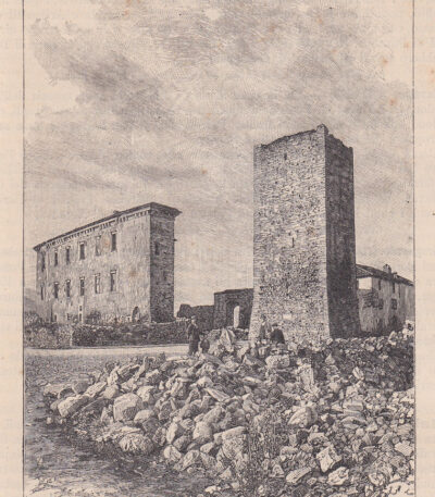
Castle in Cartosio, Acqui, 1890
20,00 €Castle in Cartosio, Acqui it is a woodcut print made by the engraver Barberis in 1890.
This work represents the Asinari Castle and an ancient tower, typical of the architecture of the time.
- Sheet size: cm. 26×18 approx.
- Image size: cm. 11×13 approx.
- Support: Paper
- Condition: Excellent

Castelnuovo di Val di Cecina, Salmon Thomas, 1738
40,00 €Castelnuovo di Val di Cecina è un’incisione realizzata da Salmon Thomas tra il 1738 e il 1768.
Questa opera rappresenta il comune di Castelnuovo di Val di Cecina, situato nello Stato Pisano, ed è un’acquaforte su rame acquarellata su carta vergellata senza filigrana.
- Sheet size: cm. 15×10 approximately, with irregular margins
- Support: Laid paper
- Condition: Excellent state of preservation
- Work taken from: ‘Lo stato presente di tutti i Paesi, e i Popoli del Mondo, Naturale, Politico, e Morale…’
- Edition: Napoli, Thomas Salmon, 1738-1768

Castelsangiovanni, 1890
20,00 €Castelsangiovanni, 1890 it's a woodblock print che rappresenta la facciata della Chiesa Maggiore.
This work is taken from a late nineteenth-century Italian text and features an image measuring approximately 9x12 cm, with text around and on the back of the sheet.
- Sheet size: cm. 30×20 approx.
- Support: Paper
- Condition: Excellent state of preservation
The entire sheet containing the print will be shipped.
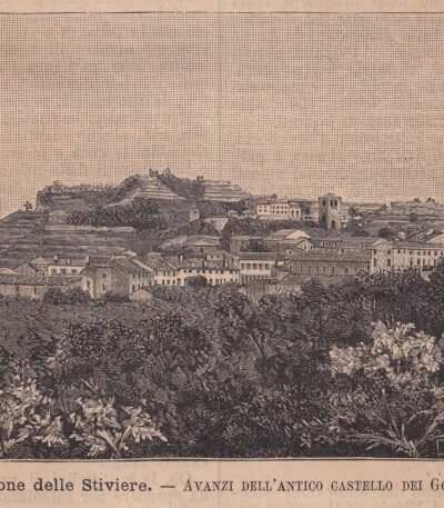
Castiglione delle Stiviere, 1890
20,00 €Castiglione delle Stiviere, 1890 it is a woodcut print representing the remains of the Ancient Gonzaga Castle, located in Castiglione delle Stiviere, in the province of Mantua.
This work is taken from a late nineteenth-century Italian text and features an image measuring approximately 9 x 12 cm, with text around and on the back of the sheet.
- Sheet size: cm. 30×20
- Image size: cm. 9×12 approx.
- Technique: Woodcut
- Condition: Excellent
- Support: Paper

Castrogiovanni, Saint-Non, 1781-86
40,00 €Castrogiovanni, Saint-Non, 1781-86 è un’incisione originale realizzata da Jean-Claude Richard de Saint-Non, noto anche come Abate di Saint-Non.
Questa magnifica opera, datata tra il 1781 e il 1786, proviene dalla prima edizione del celebre Voyage picturesque or description of the Royal Palaces of Naples and Sicilies.
- Sheet size: cm. 22×33 approx.
- Engraving size: cm. 18x25 approximately at the copper edge
- Support: Paper
- Condition: Excellent state of preservation
Questa incisione offre una bella veduta animata di Castrogiovanni, Enna, e del Lago di Proserpina, rappresentando un’importante testimonianza artistica e storica della Sicilia.
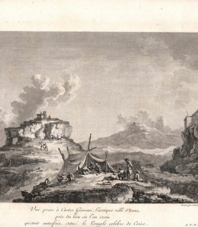
Castrogiovanni, Temple of Ceres, Saint-Non, 1781-86
40,00 €Castrogiovanni, Tempio di Ceres It is an engraving made by Jean-Claude Richard de Saint-Non between 1781 and 1786.
This magnificent original engraving comes from the first edition of the famous Voyage picturesque or description of the Royal Palaces of Naples and Sicilies.
- Sheet size: cm. 22×33 approx.
- Engraving size: cm. 18×25 approx.
- Support: Paper
- Condition: Excellent state of preservation
La veduta animata rappresenta un’importante testimonianza del patrimonio architettonico siciliano.
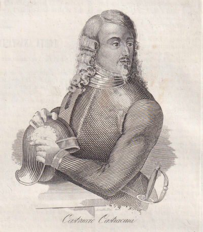
Castruccio Castracani, 1843
20,00 €Castruccio Castracani It is a copper engraving made in 1843, taken from the work Picturesque Omnibus of Naples.
Questa incisione rappresenta un’importante figura storica, Castruccio Castracani, signore di Lucca, noto per il suo ruolo nella politica e nelle battaglie del XIV secolo.
- Sheet size: cm. 11×13 approx.
- Support: Light paper
- Condition: Excellent state of preservation
- Back: Printed
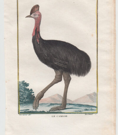
Cassowary, Leclerc de Buffon, 1770
20,00 €Cassowary It is a watercolour engraving made by Leclerc de Buffon in 1770.
This work is taken from the important volume Histoire Naturelle des Oiseaux, published in Paris.
- Sheet size: cm. 20×13 approx.
- Engraving size: cm. 13×9 approx.
- Support: Paper
- Condition: Excellent condition
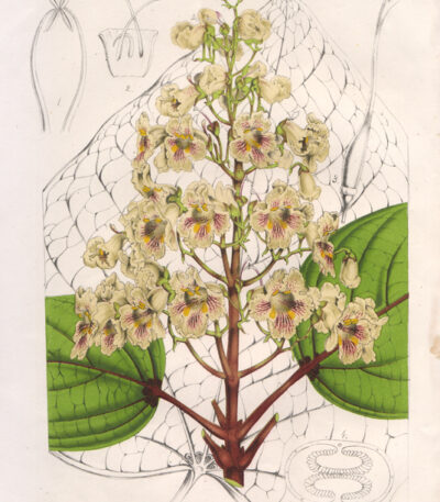
Ovate Catalpa, 1860
20,00 €Catalpa Ovata è una cromolitografia pubblicata da A. Verschaffer nel 1860.
Questa opera rappresenta la pianta di Catalpa Kampferi ed è stampata su carta di media qualità.
- Sheet size: mm. 170×260
- Technique: Chromolithography
- Condition: Excellent
- Support: Paper

Catania, 1835
20,00 €Catania, 1835 It is a burin engraving on steel made in 1835.
This work is taken from Italy by Chevalier ARTAUD, Sicily by M.DE LA SALLE and presents a beautiful animated view.
- Size of the joke: mm. 132×90 plus margins
- Support: Lightweight paper with white backing
- Condition: Excellent condition

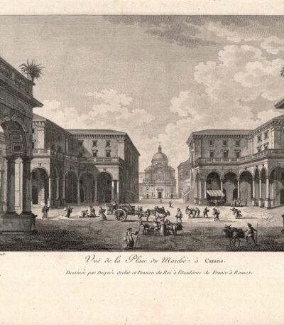
Catania, 1842
20,00 €Catania, 1842 è una litografia che rappresenta una bella veduta del piano della Statua in Catania.
Realizzata da R. Carelli e stampata da S. Puglia, questa opera è tratta dal volume Picturesque Polyorama pubblicato a Napoli nel 1842.
- Sheet size: mm. 220×140
- Condition: Excellent
- Support: Paper
- Notes: Almost no margins and writing on the back
Questa stampa è considerata non comune e rappresenta un pezzo interessante per collezionisti e appassionati di arte.

Catania, 1865
20,00 €Catania, 1865 it is a woodcut representing the Elephant Square, taken from Chorographic Dictionary of Italy by Prof. Amato Amati.
This work is illustrated with approximately 1000 colored municipal weapons and was published in Milan by Vallardi Editore in 1865.
- Sheet size: mm. 213×140
- Support: Paper
- Condition: Good
The print was cut from the book and has writing on the back.

Catania, 1871
20,00 €Catania, 1871 it's a woodcut taken from the work The Hundred Cities of Italy, published by Ariodante Manfredi in Milazzo in 1871.
Questa stampa rappresenta la città di Catania e presenta una dimensione della parte incisa di cm. 10×14 su un foglio leggero di cm. 16×23.
- Condition: Excellent condition
- Verso: White
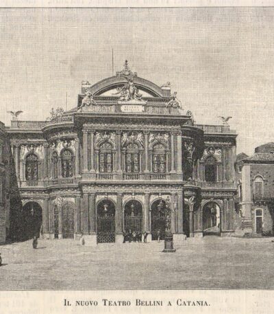
Catania, 1889
15,00 €Catania, 1889 è una xilografia che rappresenta il nuovo teatro Bellini di Catania, realizzata nel 1889.
Questa incisione è stata estratta dal volume The Italian Illustration and has a written back.
- Engraving size: mm. 152×112
- Technique: Woodcut
- Condition: Excellent
- Support: Paper

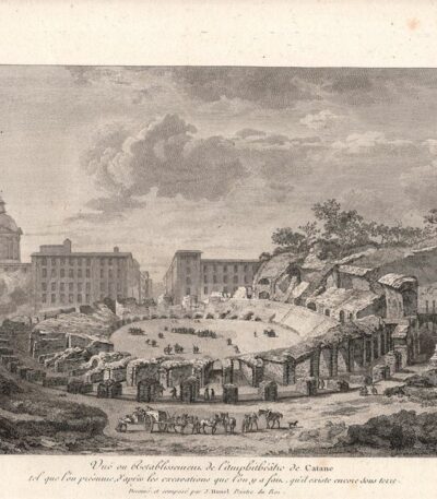
Catania, Amphitheatre, Saint-Non, 1781-86
40,00 €Catania, Anfiteatro It is an engraving made by Jean-Claude Richard de Saint-Non between 1781 and 1786.
This magnificent work is part of the first edition of the famous Voyage picturesque or description of the Royal Palaces of Naples and Sicilies.
- Sheet size: cm. 22×33 approx.
- Engraving size: cm. 18x25 approximately at the copper edge
- Support: Paper
- Condition: Excellent state of preservation
Jean-Claude Richard de Saint-Non, noto anche come Abate di Saint-Non, è stato un importante disegnatore e archeologo francese, la cui opera ha contribuito significativamente alla documentazione dei regni di Napoli e Sicilia.
Catania, Amphitheatre, Saint-Non, 1781-86
40,00 €Catania, Anfiteatro It is an engraving made by Jean-Claude Richard de Saint-Non between 1781 and 1786.
This magnificent work is part of the first edition of the famous Voyage picturesque or description of the Royal Palaces of Naples and Sicilies.
- Sheet size: cm. 22×33 approx.
- Engraving size: cm. 18×25 approx.
- Support: Paper
- Condition: Excellent
La veduta rappresenta un’animata scena dell’anfiteatro di Catania, evidenziando l’abilità artistica e il talento di Saint-Non nel catturare la bellezza dei luoghi visitati.
Catania, Water Cistern, Saint-Non, 1781-86
40,00 €Catania, Cisterna dell’acqua It is an engraving made by Jean-Claude Richard de Saint-Non between 1781 and 1786.
This magnificent work is part of the first edition of the famous Voyage picturesque or description of the Royal Palaces of Naples and Sicilies, an encyclopedic work illustrated by the author himself.
- Sheet size: cm. 22×33 approx.
- Engraving size: cm. 18×25 approx.
- Support: Paper
- Condition: Excellent state of preservation
Questa incisione offre una bella veduta animata della Sicilia, rappresentando un’importante testimonianza storica e artistica.

Catania, Etna Crater, 1835
20,00 €Catania, Etna Crater It is a burin engraving made in 1835, which offers an extraordinary animated view of the inside of the crater of Etna.
This work is taken from the volume Italy by Chevalier ARTAUD, Sicily by M.DE LA SALLE.
- Size of the joke: mm. 132×90 plus margins
- Technique: Burin
- Support: Lightweight paper with white backing
- Condition: Excellent condition

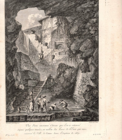
Catania, Eruption of 1669
30,00 €Catania, Eruption of 1669 It is a burin engraving made in 1835, which represents a significant historical event.
This work is taken from the volume Italy, Sicily, the Aeolian Islands, Elba Island, Sardinia, Malta, Calypso Island etc. by AUDOT père, published between 1835 and 1837.
- Sheet size: cm. 25×16 approx.
- Engraving size: cm. 25×16 approx.
- Support: Medium thickness paper
- Condition: Good state of preservation

Catania, Capuchin Garden, Saint-Non, 1781-86
40,00 €Catania, Giardino dei Cappuccini It is an engraving made by Jean-Claude Richard de Saint-Non between 1781 and 1786.
This magnificent work is part of the first edition of the famous Voyage picturesque or description of the Royal Palaces of Naples and Sicilies.
- Sheet size: cm. 22×33 approx.
- Engraving size: cm. 18×25 approx.
- Support: Paper
- Condition: Excellent state of preservation
La veduta animata offre uno sguardo affascinante sulla Sicilia del XVIII secolo.
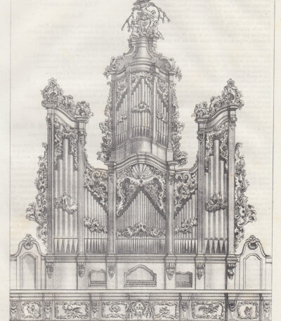
Catania, Organ, 1841
20,00 €Catania, Organo è una litografia del 1841 che rappresenta il prospetto dell’organo nella chiesa dei PP. Cassinesi a Catania.
This work is taken from Picturesque Polyorama, an important publication aimed at spreading useful knowledge to all classes of society.
- Sheet size: cm. 21×16 approx.
- Technique: Lithography
- Condition: Excellent
- Support: Paper
The print is contained in a page extracted from the book and has writing on the verso. The entire page containing the print is sent.
Catania, Market Square, Saint-Non, 1781-86
70,00 €Catania, Piazza del Mercato It is an engraving made by Jean-Claude Richard de Saint-Non between 1781 and 1786.
This magnificent original engraving comes from the first edition of the famous Voyage picturesque or description of the Royal Palaces of Naples and Sicilies.
- Sheet size: cm. 22×33 approx.
- Engraving size: cm. 18x25 approximately at the copper edge
- Support: Paper
- Condition: Excellent state of preservation
Questa bella veduta animata rappresenta un’importante testimonianza della Sicilia nel XVIII secolo.

Catania, Elephant Square, 1871
20,00 €Catania, Piazza dell’Elefante It is a woodcut made in 1871, taken from the work The Hundred Cities of Italy, pubblicata da Ariodante Manfredi a Milazzo.
Questa stampa rappresenta un’importante veduta della storica piazza catanese, con dettagli architettonici che catturano l’essenza del luogo.
- Sheet size: cm. 16×23 approx.
- Engraving size: cm. 10×14 approx.
- Support: Light paper
- Condition: Excellent condition
