
Burin

Sassari and Oristano, 1834-1837
30,00 €Sassari and Oristano It is a double steel engraving made between 1834 and 1837.
This work is taken from Italy, Sicily, the Iles Eoliennes, the Ile d'Elbe…. by Audot Père, published in Paris.
- Sheet size: cm. 25×16 approx.
- Dimensions of each engraving: cm. 11×8 approx.
- Support: Lightweight paper, white back
- Condition: Excellent state of preservation
The views are lively and decorative, making this work a fascinating piece for collectors and enthusiasts.
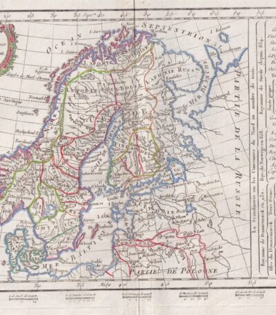
Scandinavia, CF Delamarche, 1816
70,00 €Scandinavia è un’incisione realizzata da C.F. Delamarche nel 1816, che rappresenta una mappa dettagliata della Penisola Scandinava, comprendente Norvegia, Svezia, Finlandia e Danimarca.
This work is taken from the Petit Atlas Moderne ou Collection de Cartes Elementaires, published in Paris by Delamarche.
- Sheet size: cm. 21×27 approx.
- Engraving size: cm. 20×26 approx.
- Technique: Burin
- Support: Paper
- Condition: Good
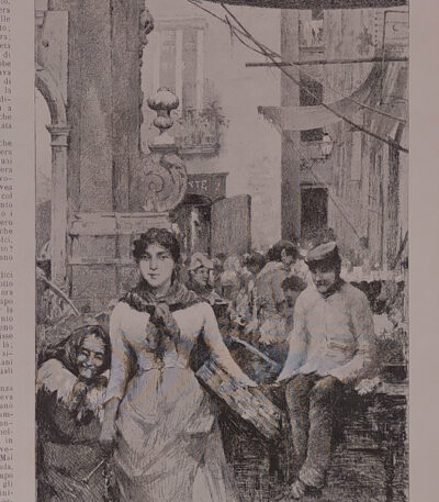
Market Scene, study by Fausto Zonaro, 1886
30,00 €Market Scene It is an engraving made by Fausto Zonaro in 1886, taken from the prestigious publication The Italian Illustration, published in Milan by the Treves Brothers.
This work captures a lively market moment, enriched by decorative writing around the image and annotations on the back of the sheet.
- Sheet size: cm. 15×31 approx.
- Engraving size: cm. 15×31 approx.
- Support: Paper
- Condition: Excellent

Simplon and Crevola Bridge, 1834
30,00 €Simplon and Crevola Bridge It is a double steel engraving made between 1834 and 1837.
This work is part of the volume Italy, Sicily, les Iles Eoliennes, l'Ile d'Elbe by Audot Père, published in Paris.
- Sheet size: cm. 25×16 approx.
- Engraving size: cm. 11x8 approximately for each
- Support: Light paper
- Condition: Excellent state of preservation
The views are lively and decorative, making this engraving a fascinating piece for collectors and enthusiasts.

Siena, Cathedral Square, 1856
40,00 €Siena, Cathedral Square it is a very fine burin engraving made in 1856.
This work was produced by Rouargue freres and is part of the volume Picturesque voyage in southern Italy, written by M. Paul De Musset and published in Paris by Morizot editeur.
- Sheet size: cm. 17×26 approx.
- Engraving size: cm. 12×17 approx.
- Support: Heavy paper
- Condition: Perfect condition

Syracuse, Dionysius, Latomie, 1835
30,00 €Syracuse, Dionysus, Latomie It is a double copper engraving made in 1835.
This work represents the Ear of Dionysius and the Latomie, and is part of the volume Italy, Sicily, the Aeolian Islands, Elba Island, Sardinia, Malta, Calypso Island etc. by Audot père, published between 1835 and 1837.
- Sheet size: mm. 270×160
- Engraving size: mm. 90×105 for each
- Support: Medium paper
- Condition: Perfect state of preservation
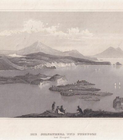
Solfatara, Pozzuoli, 1840
30,00 €Solfatara, Pozzuoli è un’incisione in acciaio realizzata intorno al 1840, che offre una bella veduta animata dei Campi Flegrei, con lo sfondo del Smoking Vesuvius.
This work is taken from Meyer's Universe e rappresenta un’importante testimonianza della bellezza naturale della regione.
- Sheet size: cm. 18×25 approx.
- Engraving size: mm. 100×155 circa
- Support: Paper
- Condition: Excellent

Sorrento, Tasso's House, 1835
35,00 €Sorrento, Tasso's House it is a double burin engraving made in 1835, which represents a view of Tasso's house.
This work is part of the volume Italy, Sicily, the Aeolian Islands, Elba Island, Sardinia, Malta, Calypso Island etc. by Audot père, published between 1835 and 1837.
- Sheet size: mm. 240×160
- Engraving size: mm. 80×110 each
- Technique: Burin
- Support: Medium paper, white back
- Condition: Perfect state of preservation

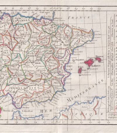
Spain and Portugal, Otto Petri, 1853
50,00 €Spain and Portugal It is a hand-engraved and hand-colored map, made by Otto Petri in 1853.
This map, part of the School Atlas Alle Deelen Der Aarde, published by J. Van Den Bosch in Rotterdam, offers a detailed representation of Iberian geography.
- Sheet size: cm. 26×34 approx.
- Map dimensions: cm. 22×27 approx.
- Support: Medium thickness paper
- Condition: Excellent condition
- Fold: Editorial fold
Spain, CF Delamarche, 1816
70,00 €Map of Spain and Portugal realizzata da C.F. Delamarche nel 1816.
This copper engraving is colored around the outline and comes from the volume Petit Atlas Moderne ou Collection de Cartes Elementaires, dedicato alla gioventù e pubblicato a Parigi da Delamarche.
- Sheet size: cm. 21×27
- Condition: Good condition, with some peeling and a central editorial crease
- Support: Paper
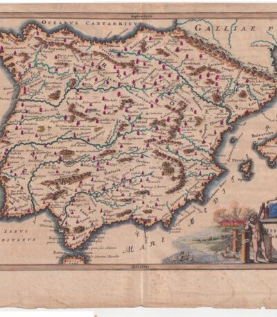
Spain. Cellarius – 1701
80,00 €Spain – Hispania Antiqua It is a copperplate map made by Christophorus Cellarius in 1701.
This work is taken from the volume Notitia Orbis Antiqui sive Geographia Plenior and presents historical and geographical details of Spain.
- Sheet size: cm. 24×33 approx.
- Engraving size: cm. 20×30 approx.
- Support: Laid paper
- Condition: Good condition
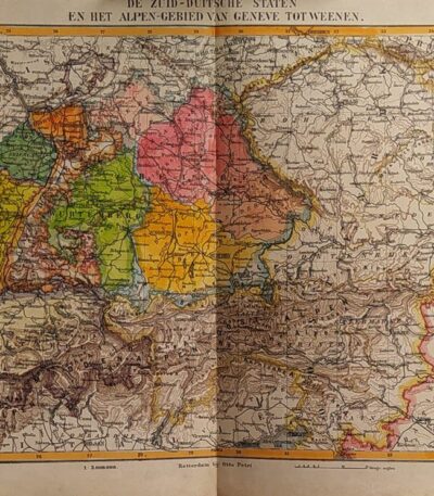
States of Germany, Otto Petri, 1853
50,00 €Stati della Germania è una mappa incisa a mano da Otto Petri nel 1853, che rappresenta gli stati della Germania meridionale e l’area delle Alpi, da Ginevra a Vienna.
Questa incisione colorata è parte del School Atlas Alle Deelen Der Aarde, published by J. Van Den Bosch in Rotterdam.
- Sheet size: cm. 26×34 approx.
- Engraving size: cm. 22×27 approx.
- Support: Medium thickness paper
- Condition: Excellent state of preservation

Equestrian statue of Vittorio Emanuele in Genoa, 1886
30,00 €Equestrian Statue of Vittorio Emanuele in Genoa It is an engraving made in 1886, taken from The Italian Illustration, published in Milan by Fratelli Treves Editori.
This work represents an important historical and artistic testimony, with accurate details and writings surrounding the image.
- Sheet size: cm. 21×31 approx.
- Engraving size: cm. 21×31 approx.
- Support: Paper
- Condition: Excellent

Study for a Putto, 19th century drawing
40,00 €Study for a Putto It is an anonymous drawing made in the 19th century.
This study, executed in pencil, features a cherub in a delicate and charming composition.
- Sheet size: mm. 340×210
- Drawing dimensions: mm. 340×210 (same design on the back)
- Support: Light sheet
- Condition: Excellent

South America, Otto Petri, 1853
50,00 €Mappa del Sud America, realizzata da Otto Petri nel 1853, è un’incisione colorata a mano che offre una rappresentazione dettagliata del continente sudamericano.
This map is part of the School Atlas Alle Deelen Der Aarde, pubblicato a Rotterdam da J. Van Den Bosch.
- Sheet size: cm. 26×34 approx.
- Engraving size: cm. 22×27 approx.
- Support: Medium thickness paper
- Condition: Excellent state of preservation
- Characteristics: White back, editorial fold

Switzerland, Otto Petri, 1853
50,00 €Map of Switzerland Made by Otto Petri in 1853, this hand-colored engraving features Switzerland and Liechtenstein.
- Sheet size: cm. 26×34
- Map dimensions: cm. 22×27
- Support: Medium thickness paper
- Condition: Excellent condition
- Taken from: School Atlas Alle Deelen Der Aarde, J. Van Den Bosch, Rotterdam
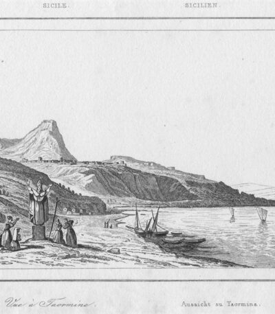
Taormina, 1835
20,00 €Taormina, 1835 It is a steel engraving made in 1835, which captures the beauty of the Sicilian landscape.
This work has a frame size of 132×90 mm, making it a medium-sized piece.
- Sheet size: mm 132×90
- Support: Lightweight paper with white backing
- Condition: Excellent

Taormina, 1835
20,00 €Taormina, 1835 It is a steel engraving made in 1835, which captures the beauty of the Sicilian landscape.
This work, also known as Bridge on the Cantara, has a strike measurement of 132x90 mm, making it a medium-sized piece.
- Sheet size: mm. 132×90
- Support: Lightweight paper with white backing
- Condition: Excellent
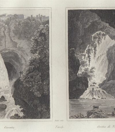
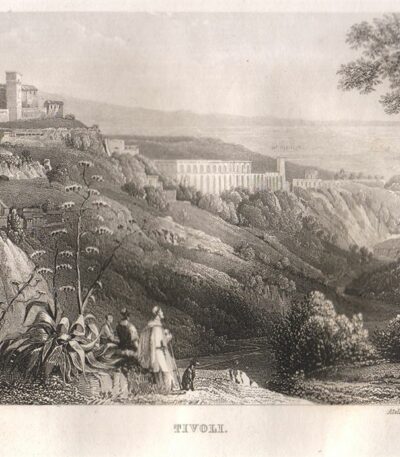
Tivoli, Cascate e Grotta di Nettuno, 1834
30,00 €Tivoli, Cascate e Grotta di Nettuno It is a double steel engraving made between 1834 and 1837.
This work is taken from the volume Italy, Sicily, les Iles Eoliennes, l'Ile d'Elbe by Audot Père, published in Paris.
Le incisioni, di dimensioni cm. 11×8 ciascuna, sono presentate su un foglio di cm. 25×16 e mostrano vedute animate e decorative di grande fascino.
- Sheet size: cm. 25×16 approx.
- Engraving size: cm. 11×8 approx.
- Support: Light paper
- Condition: Excellent state of preservation
Tivoli, Cascate, 1840
35,00 €Tivoli, Waterfalls è un’incisione in acciaio realizzata nel 1840, che offre una suggestiva veduta animata di Tivoli.
This work is part of the volume Picturesque Italy, published by Ernst Kollmann in Leipzig.
- Sheet size: mm. 230×140
- Engraving size: mm. 155×104
- Support: Paper
- Condition: Excellent
- Artist: FROMMEL del. Atelier C.Frommel e H. WINKLES sculp.
L’incisione presenta ampi margini e una qualità nitida e ben contrastata, rendendola un pezzo d’arte affascinante per collezionisti e appassionati.
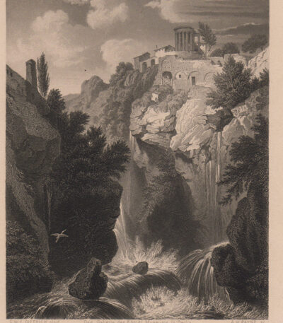
Tivoli, Cascate, 1850
30,00 €Tivoli, Waterfalls è un’incisione al bulino realizzata da Dietrich e incisa da Payne nel 1850.
Questa opera rappresenta una **bella veduta delle cascate di Tivoli**, un luogo iconico noto per la sua bellezza naturale.
- Sheet size: mm. 207×262
- Engraving size: mm. 120×151
- Support: Paper
- Condition: Excellent
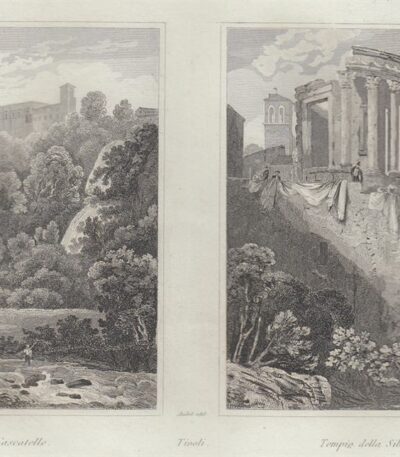
Tivoli, Cascatelle e Tempio della Sibilla, 1834
30,00 €Tivoli, Cascatelle e Tempio della Sibilla It is a double steel engraving made between 1834 and 1837.
This work, from the volume Italy, Sicily, les Iles Eoliennes, l'Ile d'Elbe di Audot Père, presenta vedute animate e decorative che catturano la bellezza del paesaggio italiano.
- Sheet size: cm. 25×16 approx.
- Engraving size: cm. 11x8 approximately for each
- Support: Light paper
- Condition: Excellent state of preservation

Türkiye and Greece, Otto Petri, 1853
50,00 €Türkiye and Greece It is a hand-engraved and hand-colored map, made by Otto Petri in 1853.
This map shows the regions of Türkiye and Greece in detail, and is part of the School Atlas Alle Deelen Der Aarde, published by J. Van Den Bosch in Rotterdam.
- Sheet size: cm. 26×34 approx.
- Map dimensions: cm. 22×27 approx.
- Support: Medium thickness paper
- Condition: Excellent state of preservation
- Fold: Editorial fold present

Türkiye, CF Delamarche, 1816
70,00 €Türkiye è una mappa incisa da C.F. Delamarche nel 1816, che rappresenta la Turchia d’Europa e parte dell’Asia.
This copper engraving is colored around the outline and is taken from the volume Petit Atlas Moderne ou Collection de Cartes Elementaires, dedicato alla gioventù e pubblicato a Parigi da Delamarche.
- Sheet size: cm. 21×27
- Condition: Good condition, with some peeling and a central editorial crease
- Support: Paper
