
Burin

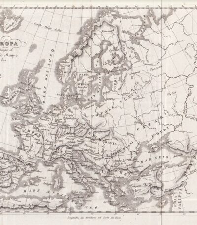
Mappa dell’Europa, 1846
40,00 €Mappa dell’Europa, 1846 è un’incisione in rame che rappresenta l’Europa al tempo delle Crociate.
This map is taken from the Storia Universale di Cesare Cantù, pubblicata a Torino presso gli Editori Giuseppe Pomba & C nel 1846.
- Sheet size: cm. 20×24 approx.
- Technique: Burin
- Condition: Buone condizioni, con varie pieghe editoriali
- Support: Paper
Mappa dell’Europa, 1846
30,00 €Mappa dell’Europa è un’incisione in rame realizzata nel 1846, che rappresenta l’Europa al tempo di Carlo Magno.
This map is taken from the Storia Universale di Cesare Cantù, pubblicata a Torino presso gli Editori Giuseppe Pomba & C.
- Sheet size: cm. 20×24 approx.
- Technique: Burin
- Condition: Good
- Support: Paper

Mappa dell’Europa, 1846
30,00 €Mappa dell’Europa, 1846 è un’incisione in rame che rappresenta l’Europa alla caduta dell’Impero d’Oriente.
This map is taken from the Storia Universale di Cesare Cantù, pubblicata a Torino presso gli Editori Giuseppe Pomba & C. nel 1846.
- Sheet size: cm. 20×24 approx.
- Technique: Burin
- Condition: Good condition
- Support: Paper
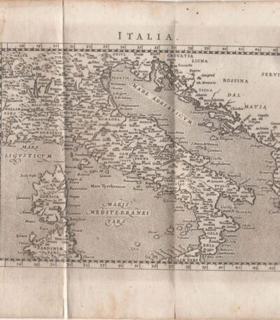
Map of Italy, Scotus, 1761
120,00 €Mappa dell’Italia it is a copper engraving made by Francesco Scotto in 1761.
This map is taken from the work Itinerary of Italy, published in Rome at the expense of Fausto Amidei, Book Merchant.
- Sheet size: cm. 18×23 approx.
- Engraving size: cm. 12×18 approx.
- Support: Laid paper
- Condition: Excellent state of preservation
- Folds: Editorials

Map of Asia, 1821
25,00 €Mappa della Asia It is a watercolour copper engraving dating back to 1821.
Questa piccola carta geografica, di dimensioni cm. 9×9 circa, è stampata su un foglio di cm. 13×15 e presenta un retro bianco.
Tratta da un testo francese dell’epoca, si presenta in excellent condition.
- Sheet size: cm. 13×15 approx.
- Engraving size: cm. 9×9 approx.
- Support: Paper
- Condition: Excellent

Map of Denmark, 1821
25,00 €Map of Denmark It is a watercolour copper engraving dating back to 1821.
This small, moderately sized map is taken from a French text of the time.
- Sheet size: cm. 13×15 approx.
- Map dimensions: cm. 9×9 approx.
- Support: Paper
- Condition: Excellent condition
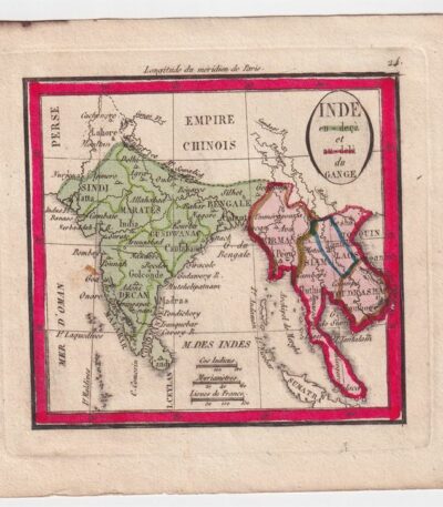
Mappa della India, 1821
25,00 €Mappa della India è un’incisione in rame acquarellata realizzata nel 1821.
Questa piccola carta geografica, di dimensioni contenute, è tratta da un testo francese dell’epoca e presenta un retro bianco.
- Sheet size: cm. 13×15 approx.
- Engraving size: cm. 9×9 approx.
- Support: Paper
- Condition: Excellent state of preservation
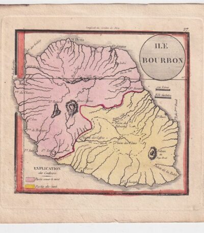
Mappa della Isola Bourbon, 1821
25,00 €Mappa della Isola Bourbon è una piccola carta geografica realizzata nel 1821, rappresentante l’isola La Riunione.
Questa incisione in rame è acquarellata e misura circa cm. 9×9, su un foglio di cm. 13×15, con retro bianco.
- Sheet size: cm. 13×15 approx.
- Map dimensions: cm. 9×9 approx.
- Support: Paper
- Condition: Excellent condition
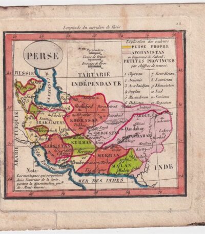
Mappa della Persia, 1821
25,00 €Mappa della Persia è un’incisione in rame acquarellata realizzata nel 1821.
This small, moderately sized map is taken from a French text of the time.
- Sheet size: cm. 13×15 approx.
- Engraving size: cm. 9×9 approx.
- Support: Paper
- Condition: Excellent state of preservation

Map of Prussia, Austria, 1821
25,00 €Mappa della Prussia, Austria It is a small geographical map made in 1821.
Questa incisione in rame è stata acquarellata e presenta dimensioni di cm. 9×9 about on a sheet of cm. 13×15.
- Back: White
- Taken from: French text from 1821
- Condition: Excellent condition

Map of Russia, 1821
25,00 €Map of Russia It is a watercolour copper engraving dating back to 1821.
This small geographical map, measuring approximately 9x9 cm, is printed on a 13x15 cm sheet, with a white back.
The work is taken from a French text of the time and is presented in excellent condition.
- Sheet size: cm. 13×15 approx.
- Engraving size: cm. 9×9 approx.
- Support: Paper
- Condition: Excellent

Map of Türkiye, 1821
25,00 €Map of Türkiye, 1821 It is a small geographical map representing Turkey in Europe, made in 1821.
This copper engraving has been watercoloured and has a white backing.
- Sheet size: cm. 13×15 approx.
- Map dimensions: cm. 9×9 approx.
- Support: Paper
- Condition: Excellent

Map of Türkiye, Asia, 1821
25,00 €Map of Türkiye, Asia It is a watercolour copper engraving dating back to 1821.
This small geographical map measures approximately 9x9 cm on a sheet of 13x15 cm.
- Back: White
- Taken from: French text from 1821
- Condition: Excellent condition

Map of the islands of America, 1821
25,00 €Mappa delle isole dell’America è un’incisione in rame acquarellata realizzata nel 1821.
Questa piccola carta geografica, di dimensioni contenute, offre una rappresentazione dettagliata delle isole americane, ed è tratta da un testo francese dell’epoca.
- Sheet size: cm. 13×15 approx.
- Engraving size: cm. 9×9 approx.
- Support: Paper
- Condition: Excellent state of preservation
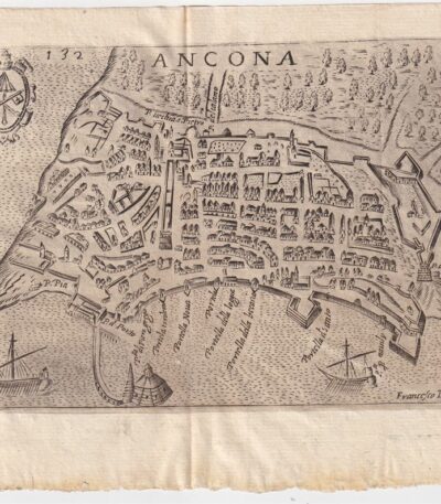
Map of Ancona, Scotus, 1659
90,00 €Map of Ancona it is a copper engraving made in 1659 by Francesco Scoto.
This map is part of the work Itinerary of Italy, published in Padua by Matteo Cadorino.
- Sheet size: cm. 16×20 approx.
- Engraving size: cm. 12×17 approx.
- Support: Light laid paper
- Condition: Excellent state of preservation
- Fold: Editorial fold
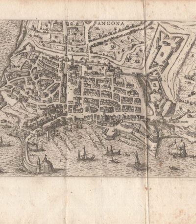
Map of Ancona, Scotus, 1761
90,00 €Map of Ancona it is an engraving made by Francesco Scotto in 1761.
This map is taken from the work Itinerary of Italy, published in Rome in 1761, at the expense of Fausto Amidei, Book Merchant.
- Sheet size: cm. 18×23 approx.
- Engraving size: cm. 12×18 approx.
- Support: Laid paper
- Condition: Excellent state of preservation
- Characteristic: Editorial fold

Mappa di Bologna, Scoto, 1761
90,00 €Mappa di Bologna it is a copper engraving made by Francesco Scotto in 1761.
This map is taken from the work Itinerary of Italy, published in Rome by Fausto Amidei, Book Merchant.
- Sheet size: cm. 18×23 approx.
- Engraving size: cm. 12×18 approx.
- Support: Laid paper
- Condition: Excellent condition
- Folds: Editorials

Map of Brescia, 1873
25,00 €Map of Brescia It is a copper engraving made in 1873.
This map is taken from the Guide in Italy, edited by Cav. PE Sacchi and published by the Artaria company of Milan.
On the back there is a white background, while on the side there is a legend of the most important sites of the city.
- Sheet size: cm. 15.5x9.5 approx.
- Condition: Excellent condition
- Support: Paper

Map of Civitavecchia, Scotus, 1761
90,00 €Mappa di Civitavecchia it is a copper engraving made by Francesco Scotto in 1761.
This map is taken from the work Itinerary of Italy, pubblicata a Roma da Fausto Amidei, mercante di libri.
- Sheet size: cm. 18×23 approx.
- Engraving size: cm. 12×18 approx.
- Support: Laid paper
- Condition: Excellent state of preservation
- Folds: Present
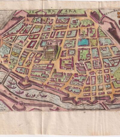
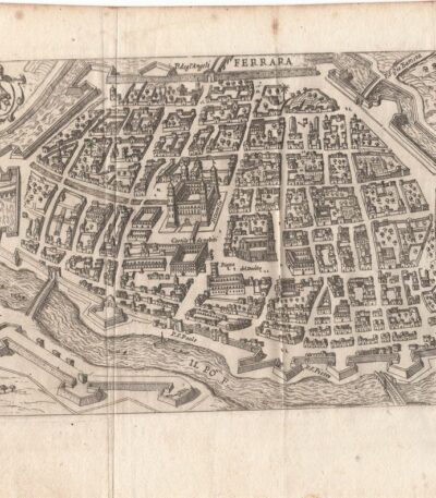
Map of Ferrara, Scotus, 1659
120,00 €Mappa di Ferrara it is a watercolour copper engraving made by Francesco Scoto in 1659.
This map is part of the work Itinerary of Italy, published in Padua by Matteo Cadorino.
- Sheet size: cm. 16×20 approx.
- Engraving size: cm. 12×17 approx.
- Support: Light laid paper
- Condition: Excellent state of preservation
- Fold: Editorale
Map of Ferrara, Scotus, 1761
90,00 €Mappa di Ferrara It is a copper engraving made in 1761 from Francesco Scotto.
This map is taken from the work Itinerary of Italy, pubblicata a Roma da Fausto Amidei, mercante di libri.
- Sheet size: cm. 18×23 approx.
- Engraving size: cm. 12×18 approx.
- Support: Laid paper
- Condition: Excellent condition
- Folds: Editorials
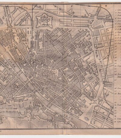
Mappa di Firenze, 1873
30,00 €Mappa di Firenze è un’incisione su rame realizzata da P. Allodi nel 1873.
This map is taken from the publication Guide in Italy, curata dal cav. P.E. Sacchi e stampata dalla ditta Artaria di Milano.
- Sheet size: cm. 15.5x20.5 approx.
- Support: Paper
- Condition: Excellent condition
- Notes: White back with legend of the most important sites of the city, features an editorial fold.

Mappa di Firenze, Scoto, 1761
90,00 €Mappa di Firenze it is a copper engraving made in 1761 by Francesco Scotto.
This map is part of the work Itinerary of Italy, pubblicata a Roma da Fausto Amidei.
- Sheet size: cm. 18×23 approx.
- Engraving size: cm. 12×18 approx.
- Support: Laid paper
- Condition: Buone, con pieghe editoriali e riparazioni con carta al verso

Mappa di Genova, 1873
30,00 €Mappa di Genova It is a copper engraving made in 1873 da P. Allodi.
Questa mappa è parte della pubblicazione Guide in Italy, curata dal cav. P.E. Sacchi e stampata dalla ditta Artaria di Milano.
- Sheet size: cm. 15.5x20.5 approx.
- Support: Paper
- Condition: Excellent condition
- Characteristics: Retro bianco con legenda dei siti più importanti della città, presenta una piega editoriale
