
Good

Province of Syracuse, B. Marzolla, 1832
90,00 €Province of Syracuse it is a geographical map created by B. Marzolla in 1832.
This lithograph has watercolored borders and is taken from the work Historical and statistical chorographic atlas of the Kingdom of the Two Sicilies, executed lithographically and dedicated to HM King Ferdinand II.
- Sheet size: cm. 45×60
- Technique: Lithography
- Condition: Good state of preservation
- Support: Paper
The paper has age stains and light humidity stains, but is free of editorial creases.
On the sides, there are historical news and statistics related to the province. The map will be shipped in a rigid tube with registered mail.
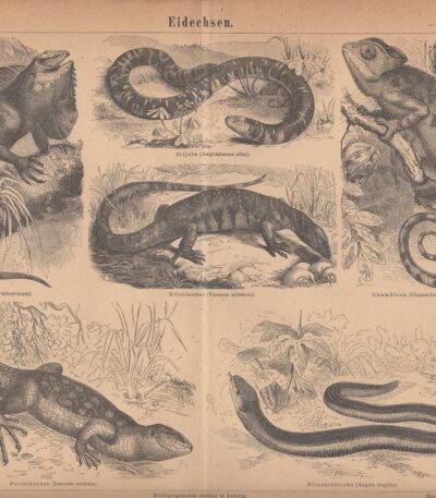
Reptiles, 1890
15,00 €Reptiles It is an 1890 lithograph depicting a variety of reptiles, including Iguana, Monitor Lizard, Chameleon, Lizard and Eel.
This work is taken from the encyclopedic publication Meyers Conversations Lexicon, published in Germany by the Bibliographischen Instituts.
- Sheet size: cm. 29×23 approx.
- Support: Paper
- Condition: Fair condition, with light yellowing and central crease

Remembrance, Antonio Cecchi, 1887
20,00 €Rimembranza è un’incisione realizzata da Antonio Cecchi nel 1887, con xilografia su legno di testa eseguita da E. Mancastroppa.
This work is taken from The Italian Illustration, published by the Treves Brothers of Milan.
- Size of the joke: mm. 215×315
- Margins: almost absent
- Condition: Buone, presenta scritte sul retro
- Support: Paper
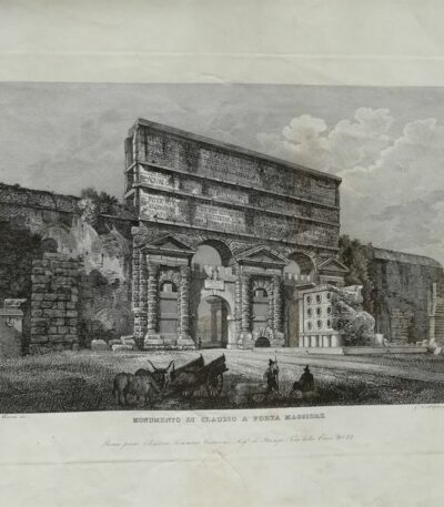
Roma, Monumento di Claudio a Porta Maggiore
50,00 €Monumento di Claudio a Porta Maggiore It is an engraving made by Gaetano Cottafavi in 1843, part of the Collection of the Principal Views of Rome and its Surroundings.
Questa opera rappresenta una veduta animata e decorativa del monumento, incisa con grande maestria.
- Sheet size: cm. 32×47 approx.
- Engraving size: cm. 17×24 approx.
- Support: Heavy paper
- Condition: Buone, con qualche macchia e un po’ sciupato
L’incisione è una prova ottima con buon contrasto e retro bianco.
Verrà spedita in tubo rigido per garantire la massima protezione.

Salvator Rosa, Figurine, 1720
1.450,00 €Salvator Rosa, Figurines It is a complete set of 60 plates, including the title plate, published by the engraver and publisher François Chéreau in Paris in the first half of the 18th century.
This collection, known as the Figurines, was originally created by Rosa in 62 etchings between 1656 and 1657.
- Sheet size: Great
- Dimensions of the tables: Variables
- Technique: Etching
- Condition: Good
- Support: Laid paper
On the frontispiece we read: SALVATOR ROSA Invenit. Liber Primus.
This edition is a good example, with six backlit prints and a few stains that do not detract from the artwork.
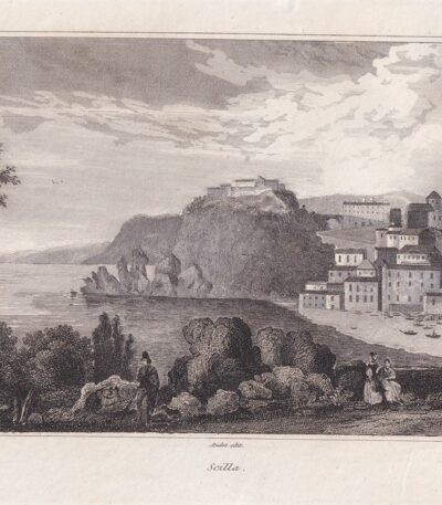
Scylla, 1835
30,00 €Scylla, 1835 It is an engraving made at burin su acciaio, proveniente dall’opera Italy, Sicily, the Aeolian Islands, Elba Island, Sardinia, Malta, Calypso Island etc. di AUDOT padre, pubblicata tra il 1835 e il 1837.
Questa incisione presenta un formato di cm. 25×16 and stands out for its medium thickness paper with white back.
- Condition: Good state of preservation
- Dimensions: Great

Syracuse, Fountain, Papyri, Saint-Non, 1786
40,00 €Syracuse, Fountain, Papyri It is an engraving made by Jean-Claude Richard de Saint-Non in 1786.
This magnificent work is part of the first edition of the famous Voyage picturesque or description of the Royal Palaces of Naples and Sicilies.
- Sheet size: cm. 22×33 approx.
- Engraving size: cm. 18×25 approx.
- Support: Paper
- Condition: Good
The engraving offers a beautiful animated view of Syracuse, Sicily, and represents an important artistic and historical testimony of the 18th century.
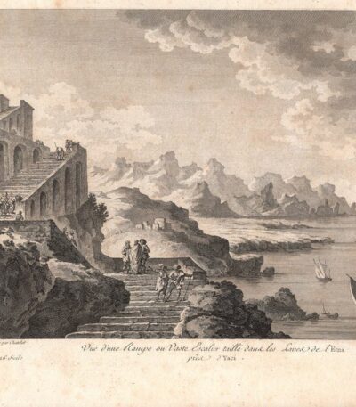
Syracuse, Stairway from Etna, Saint-Non, 1786
40,00 €Siracusa, Scala dall’Etna It is an engraving made by Jean-Claude Richard de Saint-Non in 1786.
This magnificent work is part of the first edition of the famous Voyage picturesque or description of the Royal Palaces of Naples and Sicilies.
- Sheet size: cm. 22×33 approx.
- Engraving size: cm. 18×25 approx.
- Support: Paper
- Condition: Good
La veduta animata di Siracusa offre un affascinante sguardo sulla Sicilia del XVIII secolo, rendendo questa incisione un pezzo prezioso per collezionisti e appassionati di storia.
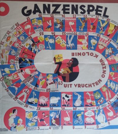
Solo, Ganzenspel, Game of the Goose, 1930
60,00 €Solo, Ganzenspel, Gioco dell’Oca è un’affascinante stampa pubblicitaria del 1930, realizzata in Olanda.
Questo gioco, noto anche come ‘Gioco dell’Oca’, presenta un design vivace con 63 caselle numerate disposte in spirale e in senso antiorario.
- Sheet size: cm. 46×64
- Technique: Offset a colori su carta leggera
- Condition: Good condition
- Support: Light paper
Al centro della stampa si legge la frase: ‘Uit Vruchten Onzer Kolonie’, mentre a sinistra sono riportate le regole del gioco. Questo gioco è un pubblicitario della margarina prodotta dalla Ditta ‘Solo’, fondata nel 1929 in Belgio. Esistono versioni sia in francese che in fiammingo (Ganzenspel).

Land of Otranto, B. Marzolla, 1832
90,00 €Land of Otranto It is a geographical map created by B. Marzolla in 1832, executed in lithography with watercolor borders.
This map is part of the work Historical and statistical chorographic atlas of the Kingdom of the Two Sicilies, dedicated to HM King Ferdinand II and published by the Royal Military Typography of Naples.
- Sheet size: cm. 45×60
- Condition: Good state of preservation
- Support: Paper
The paper has some age stains and light humidity stains, but is free of editorial creases.
On the sides of the map there are historical information and statistics of the province. The map will be sent in a rigid tube with registered mail.

Minor Valley of Caltanissetta, B. Marzolla, 1832
Minor Valley of Caltanissetta It is a geographical map made by Benedict Marzolla in 1832, performed in lithography with watercolor borders.
This map is part of the work Historical and statistical chorographic atlas of the Kingdom of the Two Sicilies, dedicated to HM King Ferdinand II and published by the Royal Military Typography of Naples.
- Sheet size: cm. 45×60
- Condition: Good state of preservation
- Support: Paper
- Details: It has age stains and light humidity stains, but is free of editorial creases.
On the sides of the map there are historical and statistical information about the provinces of Caltanissetta, Piazza, Terranova and Cefalù. The map will be sent in a rigid tube with registered mail.
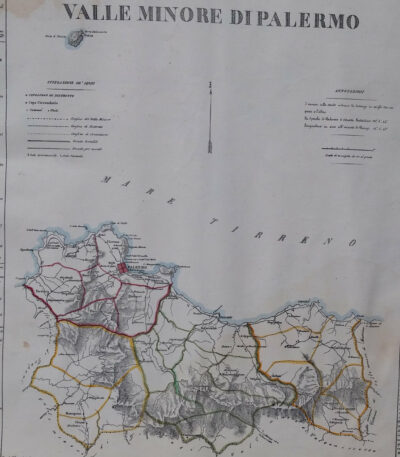
Minor Valley of Palermo, B. Marzolla, 1832
80,00 €Minor Valley of Palermo It is a lithographic geographical map made by Benedict Marzolla in 1832.
This map, part of the work Historical and statistical chorographic atlas of the Kingdom of the Two Sicilies, has watercolour borders and measures 45x60 cm.
- Sheet size: cm. 45×60
- Map dimensions: cm. 45×60
- Technique: Lithography
- Condition: Good state of preservation
- Support: Paper
The paper has age stains and light humidity stains, but is free of editorial creases.
On the sides there are historical news and statistics of the provinces of Palermo, Corleone, Termini and Cefalù. The map will be sent in a rigid tube with registered mail.
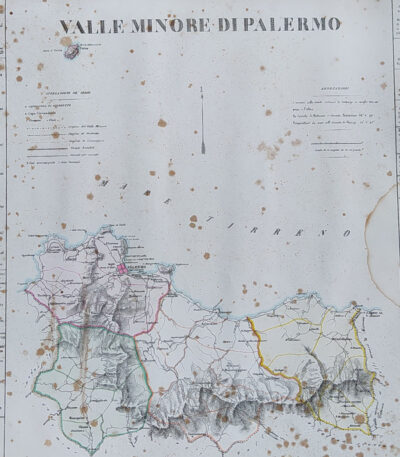
Minor Valley of Palermo, B. Marzolla, 1832
90,00 €Minor Valley of Palermo it is a geographical map created by B. Marzolla in 1832.
This lithograph has watercolored borders and is part of the work Historical and statistical chorographic atlas of the Kingdom of the Two Sicilies, dedicated to HM King Ferdinand II.
- Sheet size: cm. 45×60
- Paper size: Great
- Technique: Lithography
- Condition: Good state of preservation
- Support: Paper
The paper has some age stains and light humidity stains, but is free of editorial creases.
It will be shipped in a rigid tube with registered mail.

Minor Valley of Trapani, B. Marzolla, 1832
90,00 €Minor Valley of Trapani it is a geographical map created by B. Marzolla in 1832.
This map was made in lithography with watercolor borders and is part of the work Historical and statistical chorographic atlas of the Kingdom of the Two Sicilies, dedicated to HM King Ferdinand II.
- Sheet size: cm. 45×60
- Condition: Good state of preservation
- Support: Paper
The paper has some age stains and light humidity stains, but is free of editorial creases.
On the sides of the map there are historical information and statistics of the province. The map will be sent in a rigid tube with registered mail.
