
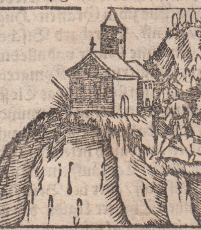
Lucerne, Switzerland, Cosmographia, 1588
Lucerna, Svizzera, Cosmographia è una mappa storica della città di Lucerna, realizzata nel 1588.
Questa xilografia, caratterizzata da scritte in ancient gothic, measures approximately cm. 9×13 and it is presented on a sheet of cm. 33×20.
Published by Sebastian Munster in the work Cosmography, one of the most popular books of the 16th century, this illustration is printed on handmade laid paper and comes from the edition From the German Lands.
- Sheet size: cm. 33×20 approx.
- Engraving size: cm. 9×13 approx.
- Support: Handmade laid paper
- Condition: Bad
Martigny, Svizzera, Cosmographia, 1588
20,00 €Martigny, Svizzera, Cosmographia, 1588 è un’incisione che rappresenta la storica città di Martigny, realizzata in xilografia con scritta in gotico antico.
Questa opera, pubblicata da Sebastian Munster nel suo celebre volume Cosmography, è considerata una delle illustrazioni più significative del XVI secolo.
- Sheet size: cm. 33×20 approx.
- Engraving size: cm. 5×5 circa
- Support: Handmade laid paper
- Condition: Excellent
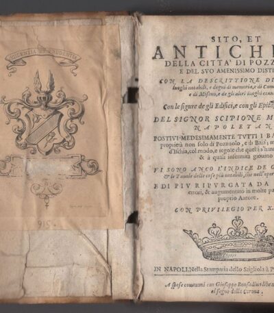
Mazzella Scipione, The City of Pozzuoli, 1596
850,00 €La Città di Pozzuoli è un’opera di Scipione Mazzella pubblicata nel 1596, che esplora le antichità e i luoghi notevoli della città di Pozzuoli e dei suoi dintorni.
Questo volume include descrizioni dettagliate di siti storici come l’anfiteatro, la Solfatara, e le terme, accompagnate da 18 xilografie che illustrano i vari luoghi menzionati. Contiene 18 xilografie intercalate nel testo: Pozzuoli con il porto, l’anfiteatro, la Solfatara, la villa di M.T.C. detta Accademia, Grotta delli cani, il lago di Lucrino, il lago Averno, del bagno di Cicerone e del sudario di Frittola, Baia città e vivai dei pesci, delle Terme di Trugli, del Circo detto Mercato di Sabato, Della Villa di Servilio Vacca, del promontorio Miseno, Di Cuma, della Grotta della Sibilla, della Grotta che va Napoli a Pozzuli e della sepoltura di Virgilio.
- Legato con. Opusculum De balneis Puteolorum Baiarum et Pithecusarum …[libellus… a Ioanne Elisio medico instauratus et in lucem editus]. A Scipione Mazzella … illustratum … Secunda editio. ex typographia Stelliolae. Neapoli. 1593.
- Dimensions: 8vo (mm. 145×101)
- Condition: Buone, con tarli nelle prime pagine che interessano anche lo scritto
- Support: Pergamena floscia coeva
- Rarity: Esemplare raro
Munster, Cosmographia, Minatore, 1550
25,00 €Munster, Cosmographia, Minatore è una xilografia realizzata nel 1550, tratta dall’opera Cosmography Universalis by Sebastian Munster.
Questo lavoro rappresenta una delle prime descrizioni del mondo in lingua tedesca e ha avuto un impatto significativo nella cartografia del XVI secolo.
- Sheet size: cm. 17×16 circa
- Image size: cm. 5×8,5 circa
- Technique: Woodcut
- Support: Laid paper
- Condition: Excellent state of preservation
La Cosmographia universalis è stata pubblicata in numerose edizioni e traduzioni, rendendola uno dei libri più popolari del suo tempo.
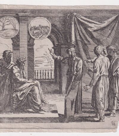
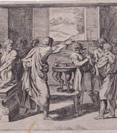
Orazio Borgianni, Giuseppe e il Faraone, 1615
120,00 €Giuseppe e il Faraone It is an engraving made by Orazio Borgianni nel 1615, che rappresenta il momento in cui Giuseppe interpreta i sogni del Faraone.
Questa opera è la tavola n.39 della serie Storie bibliche dipinte nelle Logge Vaticane da Raffaello e incise da Borgianni.
- Author: Sanzio Raffaello (inventore) e Orazio Borgianni (incisore)
- Engraving size: cm. 15×19 alla battuta del rame
- Support: Laid paper
- Condition: Excellent state of preservation
- Monogramma e data: HB 1615 in lastra
- Riferimenti: Bartsch XVII.319, Charles Le Blanc, T. II, n°1-52
Orazio Borgianni, L’unzione di David, 1615
120,00 €L’unzione di David It is an engraving made by Orazio Borgianni nel 1615, parte della serie Storie bibliche dipinte nelle Logge Vaticane da Raffaello.
Questa opera rappresenta un’importante testimonianza dell’arte rinascimentale, con disegni originali di Raphael Sanzio e incisioni di Borgianni.
- Engraving size: cm. 15×19 alla battuta del rame
- Support: Laid paper
- Condition: Excellent state of preservation
- Monogram: HB 1615 in lastra
- Riferimenti: Bartsch XVII.319, Charles Le Blanc, T. II, n°1-52
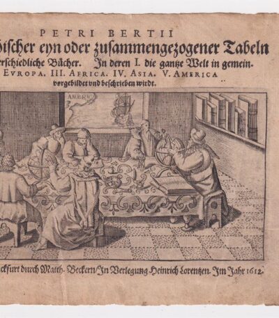
Petrus Bertius (1565-1629), Frontespizio, 1612
40,00 €Petrus Bertius (1565-1629), Frontespizio è un’incisione realizzata nel 1612, tratta dall’opera Petri Bertii Geographischer eyn oder zusammengezogener Tabeln Funff unterschiedliche Bucher.
Questa incisione presenta una dimensione di cm. 7×13 e si trova su carta vergellata con dimensioni di cm. 12×17, dotata di retro bianco.
- Condition: Excellent condition
- Support: Laid paper

Petrus Bertius, Anjou,1612
40,00 €Petrus Bertius, Anjou It is an original watercolor map made in 1612 by Petrus Bertius, a well-known 17th century geographer.
This map is from his work Petri Bertii Geographischer eyn oder zusammengezogener Tabeln Funff unterschiedliche Bucher, and is a significant example of the cartography of the time.
- Sheet size: cm. 12×17 approx.
- Map dimensions: mm. 125×83
- Support: Laid paper
- Condition: Excellent condition

Petrus Bertius, Artesia,1612
40,00 €Petrus Bertius, Artesia It is an original watercolor map made in 1612 by Petrus Bertius, a well-known French geographer.
This map is taken from Petri Bertii Geographischer eyn oder zusammengezogener Tabeln Funff unterschiedliche Bucher, a significant work of the 17th century.
- Sheet size: cm. 12×17 approx.
- Map dimensions: mm. 125×83
- Support: Laid paper
- Condition: Excellent condition
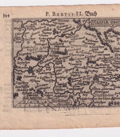
Petrus Bertius, Hesse,1612
40,00 €Petrus Bertius, Hesse It is an original map made in 1612 by Petrus Bertius (1565-1629), a well-known Dutch geographer.
This map is taken from the volume Petri Bertii Geographischer eyn oder zusammengezogener Tabeln Funff unterschiedliche Bucher.
- Paper size: mm. 125×83
- Sheet size: cm. 12×17
- Support: Laid paper
- Condition: Excellent condition

Petrus Bertius, Caletenfium,1612
40,00 €Petrus Bertius, Caletenfium It is an original watercolor map made by Petrus Bertius in 1612.
This map is taken from Petri Bertii Geographischer eyn oder zusammengezogener Tabeln Funff unterschiedliche Bucher, a work that collects various geographical representations of the time.
- Sheet size: cm. 12×17 approx.
- Map dimensions: mm. 125×83
- Support: Laid paper
- Condition: Excellent state of preservation

Petrus Bertius, Gascony, 1612
40,00 €Petrus Bertius, Gascony It is an original watercolor map made in 1612 by Petrus Bertius, a well-known 16th century geographer.
This map is from his work Geographischer eyn oder zusammengezogener Tabeln Funff unterschiedliche Bucher.
- Sheet size: cm. 12×17 approx.
- Map dimensions: mm. 125×83
- Support: Laid paper
- Condition: Excellent condition

Petrus Bertius, Hannonia,1612
40,00 €Petrus Bertius, Hannonia It is an original watercolor map made in 1612 by Petrus Bertius, a well-known French geographer.
This map is taken from the volume Petri Bertii Geographischer eyn oder zusammengezogener Tabeln Funff unterschiedliche Bucher.
- Sheet size: cm. 12×17 approx.
- Map dimensions: mm. 125×83
- Support: Laid paper
- Condition: Excellent condition

Petrus Bertius, Lotharingia 1612
40,00 €Petrus Bertius, Lotharingia 1612 It is an original watercolor map, made by Petrus Bertius in 1612.
This map is taken from Petri Bertii Geographischer eyn oder zusammengezogener Tabeln Funff unterschiedliche Bucher.
- Paper size: mm. 125×83
- Stand dimensions: cm. 12×17
- Support: Laid paper
- Condition: Excellent condition

Petrus Bertius, Picardy,1612
40,00 €Petrus Bertius, Picardia è una mappa originale acquarellata realizzata nel 1612 da Petrus Bertius, un noto geografo olandese.
This map is taken from Petri Bertii Geographischer eyn oder zusammengezogener Tabeln Funff unterschiedliche Bucher.
- Paper size: mm. 125×83
- Stand dimensions: cm. 12×17
- Support: Laid paper
- Condition: Excellent condition

Petrus Bertius, Vaucluse, 1612
40,00 €Petrus Bertius, Vaucluse It is an original watercolor map made in 1612 by Petrus Bertius (1565-1629).
This map is taken from Petri Bertii Geographischer eyn oder zusammengezogener Tabeln Funff unterschiedliche Bucher.
- Sheet size: cm. 12×17 approx.
- Map dimensions: mm. 125×83
- Support: Laid paper
- Condition: Excellent condition

Petrus Bertius, Veromadui,1612
40,00 €Petrus Bertius, Veromadui It is an original watercolor map made in 1612 by Petrus Bertius, a well-known French geographer.
This map is taken from Petri Bertii Geographischer eyn oder zusammengezogener Tabeln Funff unterschiedliche Bucher, pubblicato nello stesso anno.
- Sheet size: cm. 12×17 approx.
- Map dimensions: mm. 125×83
- Support: Laid paper
- Condition: Excellent condition

Petrus Bertius, Westfalia,1612
40,00 €Petrus Bertius, Westfalia è una mappa originale acquarellata realizzata nel 1612 da Petrus Bertius, un geografo di origine olandese.
This map is taken from the volume Petri Bertii Geographischer eyn oder zusammengezogener Tabeln Funff unterschiedliche Bucher.
- Sheet size: cm. 12×17 approx.
- Map dimensions: mm. 125×83
- Support: Laid paper
- Condition: Excellent condition
Svizzera, Cosmographia, 1588
30,00 €Svizzera, Cosmographia, 1588 è una mappa in legno della Svizzera, pubblicata da Sebastian Munster nel suo celebre volume Cosmography.
Questa opera, che presenta scritte in ancient gothic, è un esempio significativo della cartografia del XVI secolo.
- Sheet size: cm. 33×20 approx.
- Engraving size: cm. 8×13 approx.
- Support: Handmade laid paper
- Condition: Excellent
There Cosmography è considerata uno dei libri più popolari e di successo del XVI secolo, contribuendo in modo significativo alla diffusione della conoscenza geografica dell’epoca.
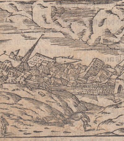
Terremoto di Basilea, Cosmographia, 1588
30,00 €Terremoto di Basilea It is an engraving made in woodcut, pubblicata nel 1588 da Sebastian Munster all’interno della sua celebre opera Cosmography.
Questa illustrazione, caratterizzata da una scritta in ancient gothic, rappresenta un evento significativo e fa parte di uno dei libri più popolari del XVI secolo.
- Sheet size: cm. 33×20 approx.
- Engraving size: cm. 7×12 approx.
- Support: Handmade laid paper
- Condition: Excellent
