
XVII

Jacques Callot, Varie Figure, 1611-1621
650,00 €Varie Figure è una serie di incisioni realizzate da Jacques Callot tra il 1611 e il 1621. Questa collezione comprende 14 tavole su un totale di 16, tutte incise in etching on laid paper.
Ogni tavola misura circa cm. 9×9 and it is presented on a sheet of cm. 16×11. Le incisioni mostrano piccole tracce di carta gommata al verso, sul margine superiore, che non influenzano la qualità visiva dell’opera. Due tavole presentano un piccolo strappo riparato con carta al verso, ma nel complesso sono in excellent condition e conservano ampi margini.
- Era: XVII
- Technique: Burin
- Condition: Excellent
- Dimensions: Small
- Support: Paper
Questa selezione di incisioni è di grande valore e raramente si trova sul mercato, rendendola un’importante aggiunta per collezionisti e appassionati di arte.
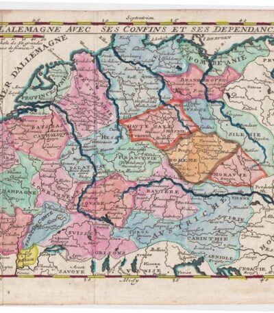
M. Demasso, Mappa della Germania, 1700
80,00 €Map of Germany è un’incisione realizzata da M. Demasso nel 1700, intitolata L’Alemagne avec ses confins et ses dependances.
Questa mappa è colorata all’acquarello e presenta dettagli accurati sui confini e le dipendenze della Germania dell’epoca.
- Sheet size: cm. 16×23 approx.
- Map dimensions: cm. 14×18 approx.
- Support: Paper
- Condition: Excellent
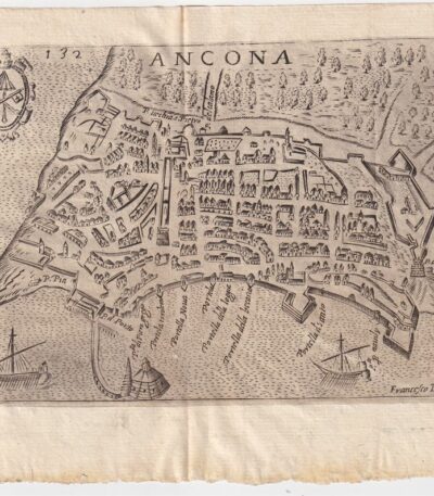
Map of Ancona, Scotus, 1659
90,00 €Map of Ancona it is a copper engraving made in 1659 by Francesco Scoto.
This map is part of the work Itinerary of Italy, published in Padua by Matteo Cadorino.
- Sheet size: cm. 16×20 approx.
- Engraving size: cm. 12×17 approx.
- Support: Light laid paper
- Condition: Excellent state of preservation
- Fold: Editorial fold
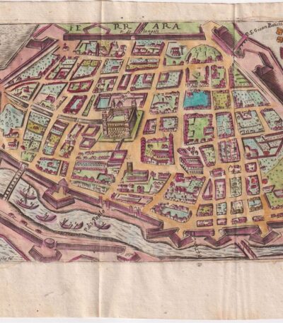
Map of Ferrara, Scotus, 1659
120,00 €Mappa di Ferrara it is a watercolour copper engraving made by Francesco Scoto in 1659.
This map is part of the work Itinerary of Italy, published in Padua by Matteo Cadorino.
- Sheet size: cm. 16×20 approx.
- Engraving size: cm. 12×17 approx.
- Support: Light laid paper
- Condition: Excellent state of preservation
- Fold: Editorale

Map of Mantua, Scoto, 1659
120,00 €Map of Mantua It is a watercolour copper engraving made in 1659 by Francis Scotus.
This map is part of the work Itinerary of Italy, published in Padua by Matteo Cadorino.
- Sheet size: cm. 16×20 approx.
- Engraving size: cm. 12×17 approx.
- Support: Light laid paper
- Condition: Excellent condition
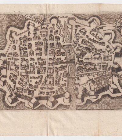
Map of Parma, Scotus, 1659
90,00 €Map of Parma it is a copper engraving made by Francesco Scoto in 1659.
This map is part of the work Itinerary of Italy, published in Padua by Matteo Cadorino.
- Sheet size: cm. 16×20 approx.
- Engraving size: cm. 12×17 approx.
- Support: Light laid paper
- Condition: Excellent condition
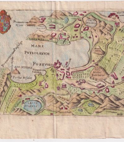
Map of Pozzuoli, Scotus, 1659
Map of Pozzuoli it is a watercolour copper engraving made by Francesco Scoto in 1659.
This map is part of the work Itinerary of Italy, published in Padua by Matteo Cadorino.
- Sheet size: cm. 16×20 approx.
- Engraving size: cm. 12×17 approx.
- Support: Light laid paper
- Condition: Excellent condition
- Characteristic: Editorial fold
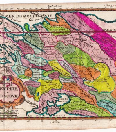
Matthieu Ogier, Map of the Russian States, Moscow, 1700
40,00 €Map of Russian states It is an engraving made by Matthieu Ogier in 1700.
This map, titled The Empire of Moscow, is colored in watercolour and represents a precious cartographic testimony of the time.
- Sheet size: cm. 16×23 approx.
- Map dimensions: cm. 14×18 approx.
- Technique: Burin
- Condition: Excellent
- Support: Paper
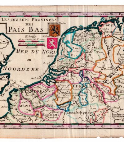
Matthieu Ogier, Map of the Netherlands, Holland, 1700
50,00 €Matthieu Ogier, Map of the Netherlands It is an engraving made in 1700, representing the seventeen provinces of the Netherlands.
This map was engraved by Matthieu Ogier and hand-colored in watercolor, making it a unique and fascinating piece.
- Sheet size: cm. 16×23 approx.
- Map dimensions: cm. 14×18 approx.
- Support: Paper
- Condition: Excellent
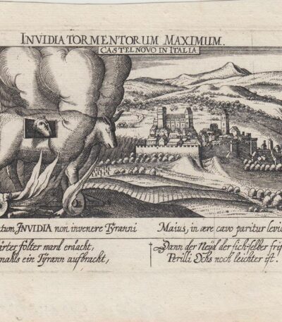
Meisner, Castelnovo di Porto, 1678
60,00 €Meisner, Castelnovo di Porto, 1678 è una veduta tratta dall’edizione del 1678 della celebre Sciagraphia Cosmica.
Questa incisione in rame presenta margini e si trova in perfetto stato di conservazione.
- Sheet size: cm. 13×19 approx.
- Engraving size: cm. 10×15 approx.
- Support: Laid paper without watermark
- Condition: Excellent state of preservation
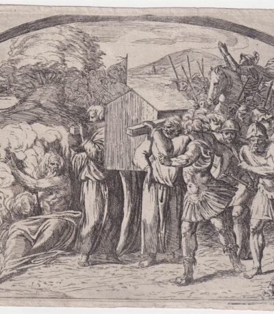
Orazio Borgianni, Arca dell’Alleanza, 1615
120,00 €Arca dell’Alleanza è un’incisione realizzata da Orazio Borgianni nel 1615, che rappresenta il Trasporto dell’arca dell’Alleanza a Gerusalemme.
Questa opera è la tavola n.39 della serie Storie bibliche dipinte nelle Logge Vaticane da Raffaello, con incisioni di Borgianni.
- Author: Sanzio Raffaello (e aiuti) (1483/1520), inventore; Borgianni Orazio (1578/1616), incisore
- Engraving size: cm. 15×19 alla battuta del rame
- Support: Laid paper
- Condition: Excellent state of preservation
- Monogramma e data: HB 1615 in lastra
- Riferimenti: Bartsch XVII.319, Charles Le Blanc, T. II, n°1-52
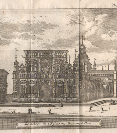
Pavia, 1707, Charterhouse
40,00 €Pavia, 1707, Charterhouse è un’incisione realizzata da Magdeleine Horthemels nel 1707, che rappresenta una veduta della Certosa di Pavia.
This work is taken from the volume The delights of Italy, pubblicato da De Rogissart a Parigi.
- Sheet size: mm. 150×120
- Technique: Burin
- Condition: Excellent
- Support: Paper

Philippus Cluverius (1580-1622), Germania, 1686
80,00 €Philippus Cluverius è un’incisione in rame acquarellata realizzata nel 1686, proveniente dall’opera Introductionis in universam geographiam, tam veterem quam novam, libri VI, published in Amsterdam.
Questa incisione rappresenta un’importante testimonianza della geografia del XVII secolo e misura mm. 134×140.
- Sheet size: Small
- Engraving size: mm. 134×140
- Support: Laid paper
- Condition: Excellent

Philippus Cluverius (1580-1622), England, 1686
80,00 €Philippus Cluverius (1580-1622) presents a map of England, part of the British Isles, dated 1686.
This copper engraving is watercolour and comes from the work Introductionis in universam geographiam, tam veterem quam novam, libri VI, published in Amsterdam in 1686.
- Sheet size: mm. 134×140
- Technique: Burin
- Support: Laid paper
- Condition: Excellent

Philippus Cluverius (1580-1622), Liguria, 1686
80,00 €Philippus Cluverius è un’incisione in rame acquarellata realizzata nel 1686, rappresentante la Liguria, Italia Settentrionale.
This work is taken from the volume Introductionis in universam geographiam, tam veterem quam novam, libri VI, published in Amsterdam.
- Sheet size: mm. 134×140
- Support: Laid paper with partial watermark
- Condition: Excellent condition

Philippus Cluverius (1580-1622), Map of Europe, 1686
80,00 €Philippus Cluverius – Map of Europe It is a watercolour copper engraving made in 1686.
This map is taken from the work Introductionis in universam geographiam, tam veterem quam novam, libri VI, published in Amsterdam.
- Sheet size: mm. 134×140
- Technique: Burin
- Support: Laid paper
- Condition: Excellent condition
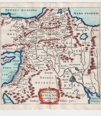
Philippus Cluverius (1580-1622), Mappa della Armenia 1686
60,00 €La Mappa della Armenia It is an engraving made by Philippus Cluverius nel 1686, che rappresenta non solo l’Armenia, ma anche la Siria e la Mesopotamia.
This map is taken from the work Introductionis in universam geographiam, tam veterem quam novam, libri VI, published in Amsterdam.
- Sheet size: mm. 134×140
- Technique: Incisione in rame acquarellata
- Support: Laid paper
- Condition: Excellent condition

Philippus Cluverius (1580-1622), Map of China, 1686
70,00 €Philippus Cluverius (1580-1622) presents a map of China and Japan, built in 1686.
This copper engraving is watercolour and comes from the work Introductionis in universam geographiam, tam veterem quam novam, libri VI, published in Amsterdam.
- Sheet size: mm. 134×140
- Technique: Burin
- Support: Laid paper
- Condition: Excellent
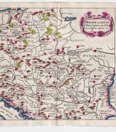
Philippus Cluverius (1580-1622), Map of Dacia, 1686
60,00 €Philippus Cluverius – Map of Dacia It is a watercolour copper engraving made in 1686.
This map represents Dacia, Hungary, Poland and Moesia, and is taken from the work Introductionis in universam geographiam, tam veterem quam novam, libri VI, published in Amsterdam.
- Sheet size: mm. 134×140
- Technique: Burin
- Support: Laid paper
- Condition: Excellent

Philippus Cluverius (1580-1622), Mappa della Francia, 1686
80,00 €La Mappa della Francia It is an engraving made by Philippus Cluverius nel 1686.
This map, part of the work Introductionis in universam geographiam, tam veterem quam novam, è un esempio significativo della cartografia del XVII secolo.
- Sheet size: cm. 13.4×14 approx.
- Engraving size: cm. 13.4×14 approx.
- Support: Laid paper
- Condition: Excellent state of preservation

Philippus Cluverius (1580-1622), Mappa della Germania 1686
60,00 €Philippus Cluverius (1580-1622) presents a Mappa della Germania Inferiore, built in 1686.
This copper engraving is watercolour and comes from the work Introductionis in universam geographiam, tam veterem quam novam, libri VI, published in Amsterdam in 1686.
- Sheet size: mm. 134×140
- Technique: Burin
- Support: Laid paper
- Condition: Excellent

Philippus Cluverius (1580-1622), Mappa della Germania, 1686
60,00 €Philippus Cluverius – Mappa della Germania It is a watercolour copper engraving made in 1686.
This map is taken from the work Introductionis in universam geographiam, tam veterem quam novam, libri VI, published in Amsterdam.
- Sheet size: mm. 134×140
- Support: Laid paper
- Condition: Excellent condition

Philippus Cluverius (1580-1622), Mappa della Germania, 1686
60,00 €Philippus Cluverius (1580-1622) presents a Map of Germany realizzata nel 1686.
Questa incisione in rame è stata acquarellata e proviene dall’opera Introductionis in universam geographiam, tam veterem quam novam, libri VI, published in Amsterdam.
- Sheet size: mm. 134×140
- Technique: Burin
- Support: Laid paper
- Condition: Excellent
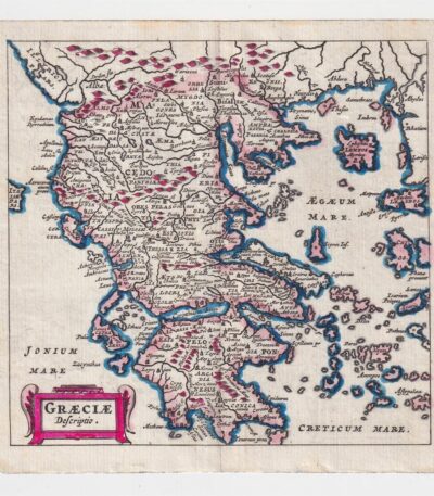
Philippus Cluverius (1580-1622), Map of Greece, 1686
60,00 €Philippus Cluverius – Map of Greece It is a watercolour copper engraving made in 1686.
This map is taken from the work Introductionis in universam geographiam, tam veterem quam novam, libri VI, published in Amsterdam.
- Sheet size: cm. 13.4×14 approx.
- Support: Laid paper
- Condition: Excellent state of preservation
