Filter by price
Filter by technique
- Woodcut (16)
- Etching (17)
- Other (2)
- Burin (61)
- Copper engraving (1)
- Lithography (32)
Product categories
- Allegories 25
- Anatomy Medicine 187
- Animals Zoology 163
- Old Masters 1232
- Famous Old Masters 637
- Berchem Nicolaes 35
- Callot Jacques 31
- Of the Beautiful Stephen 94
- David Deuchar 169
- Dore Gustave 103
- Dürer Albrecht 19
- Gabriel Perelle 24
- Hogarth William 87
- Salvator Rosa 21
- Van Ostade Adriaen 83
- Ancient Italian Masters 364
- Ancient Foreign Masters 823
- Famous Old Masters 637
- Architecture 41
- Arts and Crafts 406
- 20th Century Artists 16
- Astrology 59
- Astronomy 25
- Children 89
- Bartholomew Pinelli 123
- Botany Flowers Fruit 118
- Cartography 412
- Consalvo Carelli 31
- Costumes 547
- Drawings and Watercolors 130
- Ex libris 232
- Falsi d'Autore 3
- Butterflies 22
- Games 16
- Joseph Maria Mitelli 40
- Central Italy 960
- Insular Italy 274
- Southern Italy 898
- Avellino 9
- Bari 9
- Barletta 5
- Benevento 12
- Toasts 13
- Phlegraean Fields 83
- Campobasso 10
- Capri 18
- Caserta 43
- Catanzaro 4
- Chieti 8
- Cosenza 7
- Croton 2
- Foggia 15
- Ischia 20
- Isernia 3
- The Eagle 25
- Lecce 13
- Matera 3
- Naples 453
- Naples Province 63
- Pompei 49
- Power 9
- Reggio Calabria 16
- Salerno 74
- Sorrento 25
- Taranto 4
- Teramo 7
- Vesuvius 25
- Northern Italy 1028
- Alexandria 67
- Aosta 36
- Asti 9
- Belluno 9
- Bergamo 12
- connecting rod 3
- Bologna 37
- Bolzano 15
- Brescia 21
- How 31
- Cremona 16
- Wedge 43
- Ferrara 24
- ForliCesena 3
- Genoa 70
- Imperia 19
- La_Spezia 12
- Lecco 6
- Praise 3
- Mantua 23
- Milan 53
- Modena 16
- Monza 3
- New 9
- Padua 27
- Parma 15
- Pavia 27
- Pleasure 10
- Ravenna 23
- Reggio Emilia 9
- Rimini 4
- Rovigo 4
- San_Marino 2
- Savona 10
- Sondrio 18
- Turin 76
- Trento 25
- Treviso 13
- Trieste 21
- Udine 8
- Varese 8
- Venice 94
- Verbano Ossola 16
- Vercelli 10
- Verona 48
- Vicenza 27
- Ancient Books 55
- Ancient Maps 249
- Masks 45
- Ovid's Metamorphoses 65
- Military Battles 82
- Mythology 110
- Fashion 39
- Monarchy 96
- Monograms Numbers 221
- Music 37
- Famous People 588
- Saints 212
- Ancient Holy Cards 250
- Holy cards 20th century 57
- Genre Scenes 409
- Science and Technology 59
- Watercolor Prints 63
- Antique Prints for Events and Weddings 17
- Prints with Marine Ships 12
- Prints with Nudes 23
- Prints from Paintings 447
- Decorative Prints 626
- Large Format Prints 181
- Religion Prints 728
- Erotic Prints 110
- Small Size Prints 160
- Prints cm7x10 31
- Prints cm8x11 75
- Prints cm9x12 54
- Coats of arms 116
- History and Culture 983
- Universal Cosmography 119
- Dance of Death 97
- Philosophy 9
- Literature 142
- History and Culture 371
- Natural history 441
- Theater 43
- Birds 174
- Humor Satire 43
- Views of Foreign Cities 447
- Africa 3
- Albania 3
- America 1
- Australia 2
- Austria 17
- Belgium 9
- Bulgaria 1
- Canada 1
- China 4
- Croazia 2
- Denmark 2
- Egypt 6
- France 70
- Germany 75
- Greece 47
- India 2
- England 20
- Israel 7
- Lebanon 2
- Malta 11
- Netherlands 2
- Paris 14
- Poland 2
- Portugal 8
- Repubblica Ceca 2
- Russia 12
- Syria 2
- Spain 41
- United States 6
- Swiss 51
- Tunisia 6
- Türkiye 15
- Italian City Views 2919
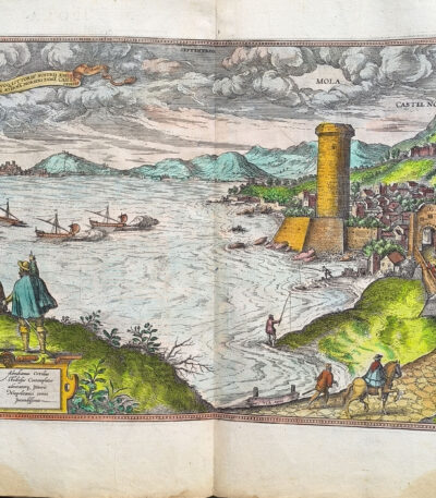
1578, Georg Braun, Frans Hogenberg, watercolor map of Mola Gaeta
280,00 €Gaeta Millstone It is a splendid map made in 1578 by George Brown And Frans Hogenberg, with the editorial contribution of R.A. Skelton.
This engraving, hand-watercoloured, comes from the famous atlas Cities of the Earth's Orb, published under the direction of Abraham Ortelius. The work represents an important cartographic and artistic testimony of the sixteenth century, illustrating in great detail the city and the surrounding territory.
- Era: 16th century
- Technique: Watercolor etching
- Dimensions: Large (cm 42×54)
- Support: Laid paper
- Condition: Very good (minor repairs to upper corners on back)
This map is a piece of great historical and artistic value, ideal for collectors and lovers of ancient cartography.
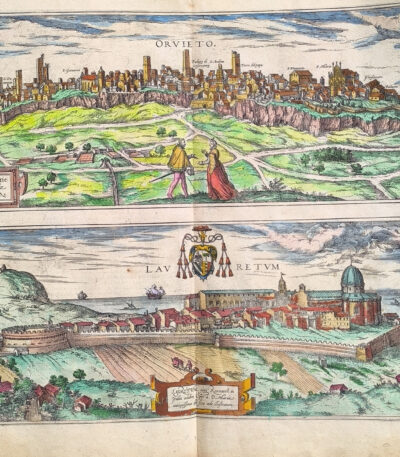
1578, Georg Braun, Frans Hogenberg, watercolor map of Orvieto and Loreto
280,00 €Map of Orvieto and Loreto, made by George Brown, Frans Hogenberg And R.A. Skelton in 1578.
This beautiful print is a fine hand-painted watercolour etching from the famous volume Cities of the Earth's Orb, one of the most important urban atlases of the Renaissance. The work offers a detailed topographical representation of Orvieto and Loreto, capturing the beauty and architectural structure of two historic Italian cities.
- Era: 16th century
- Technique: Watercolor etching
- Dimensions: Large (cm. 42 x 54)
- Support: Laid paper
- Condition: Excellent
This map, in addition to its aesthetic value, represents an important historical testimony, perfect for collectors or enthusiasts of ancient cartography.
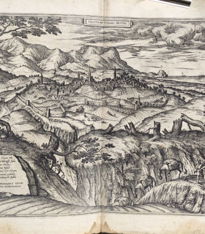
1578, Georg Braun, Frans Hogenberg, map of Velletri from Ortel's Orbis Terrarum
280,00 €Map of Velletri is a splendid engraving created by Georg Braun and Frans Hogenberg in 1578, part of the famous atlas Civitates Orbis Terrarum edited by Abraham Ortelius.
This rare historical view depicts in great detail the city of Velletri in the 16th century, offering a precious testimony of Renaissance cartography.
- Era: 16th century
- Technique: Etching
- Sheet size: cm. 42 x 54 (large format)
- Support: Laid paper
- Condition: Excellent condition
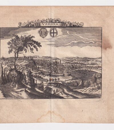
1712, Ancient map of Verona
50,00 €Ancient map of Verona from 1712 is a copper engraving that represents one of the most fascinating historical maps of the city.
This map is taken from the volume The Delights of Italy by De Rogissart and presents accurate details of the Veronese topography of the time.
- Sheet size: cm. 16×17 approx.
- Engraving size: cm. 11×14 approx.
- Support: Light laid paper
- Condition: Excellent state of preservation
- Rarity: Rare
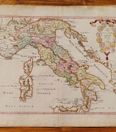
1718, Southern Italy, C.Weigel
220,00 €1718, Southern Italy it's a lithography with contemporary watercolour, made by C. Weigel.
This map represents ancient Italy from Octavian Augustus in Regions XI described.
- Place of publication: Nuremberg
- Year of publication: 1718
- Sheet size: cm. 39×47
- Condition: Excellent, with editorial center fold
- Rarity: Rare representation, with excellent colouring
1718, Southern Italy, C.Weigel
280,00 €Map of Southern Italy It is a lithograph made by C. Weigel in 1718, characterised by a contemporary coloring which enhances its beauty.
This map, titled Magna Graecia Description, was published in Nuremberg with the privilege of the SC Majest.
- Sheet size: cm. 38×45
- Technique: Lithography
- Condition: Excellent, with editorial center fold
- Support: Paper
Rare and valuable representation, with high quality colouring.
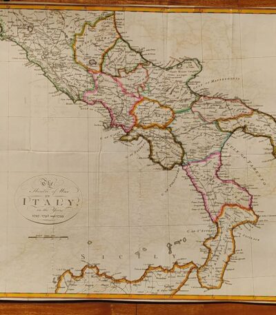
1800, Map of Southern Italy
120,00 €1800, Map of Southern Italy It is a hand-colored lithograph representing The Theater of War in Italy in the years 1797, 1798 and 1799.
This map offers a rare and detailed view of the conflict, with exceptional colouring that enhances the details.
- Sheet size: cm. 38×45
- Condition: Excellent condition
- Technique: Lithography
- Support: Paper
1800, Map of Southern Italy
80,00 €1800, Map of Southern Italy it is a lithograph that represents The Theatre of War in Italy in the years 1797, 1798 and 1799.
This map offers a rare and detailed view of the war context of the time, making it a piece of great historical interest.
- Sheet size: cm. 38×45 approx.
- Technique: Lithography
- Condition: Excellent condition
- Support: Paper
1800, Map of Northern Italy
120,00 €Map of Northern Italy It is a lithograph made in 1800, representing the theatre of war in Italy during the campaigns of 1796 and 1799.
This hand-colored map is a rare historical representation with exceptional coloring.
- Sheet size: cm. 41×65
- Condition: Excellent, with some editorial creases
- Technique: Lithography
- Support: Paper
1800, Map of Northern Italy
80,00 €1800, Map of Northern Italy It is a lithograph representing a detailed map of the theatre of war in Italy during the campaigns of 1796 and 1799.
This rare representation offers a fascinating glimpse into the historical events of that period.
- Sheet size: cm. 41×65
- Condition: Excellent, with some editorial creases
- Support: Paper
1825 World Map Planisphere Giraldon Bonivet Watercolor
80,00 €Map of the World in two hemispheres, by L. Vivien geographer engraved by Giraldon Bonivet, 1825, Paris. Planisphere. On unlaid paper of medium thickness, cm.29×45, white back. Repair on the back with paper, slight peeling and stains. Colored around the edge at a later date.
1838 Map of Italy and Sicily watercolored by Delamarche
80,00 €Map of Italy and Sicily, by Delamarche, 1838. On unlaid paper of medium thickness, cm.34×48, white back. Colored with watercolours at a later date. Excellent condition.
1838 Delamarche coloured globe in two hemispheres
80,00 €Globe in two hemispheres, by Delamarche, 1838, Paris. On medium-thickness unlaid paper, 34 x 48 cm, white back. Colored around the edges in contemporary period. Excellent condition.
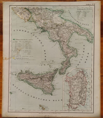
1855, Map of Southern Italy
80,00 €1855, Map of Southern Italy It is a lithograph made by C. Flemming, published in 1855.
This map represents Southern Italy and Sardinia, and was produced by Berghaus, Heinrich and Sohr, Karl.
- Sheet size: cm. 44×37
- Coloration: Contemporary with the outline
- Condition: Excellent condition
- Rarity: Rare representation with excellent coloring
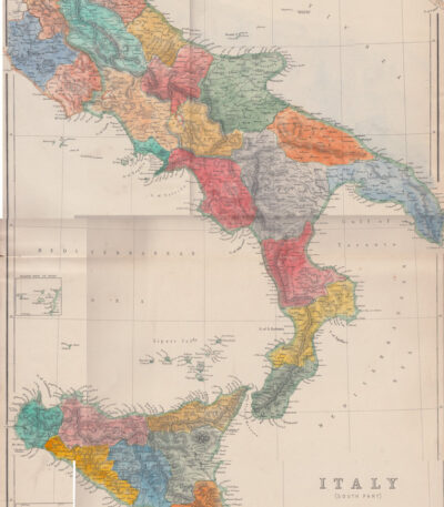
1860, Colored map of Central and Southern Italy
80,00 €1860, Colored map of Central and Southern Italy is a steel engraving published in 1860 by Blackie & Son, London, for The Imperial Atlas of Modern Geography by Walter Graham Blackie.
This map has been hand colored with watercolor and features a central editorial fold.
- Sheet size: cm. 54×37
- Support: Strong paper
- Condition: Excellent condition
The back is white.
1861, Map of Southern Italy
60,00 €1861, Map of Southern Italy It is a historical map representing the regions of Southern Italy, including Sicily, Sardinia and Corsica.
This card was made by Reichard and is part of the volume Ancient Earth Orb, published circa 1861.
- Sheet size: cm. 33×39
- Coloration: Manual
- Condition: Excellent condition
- Rarity: Rare representation with excellent coloring
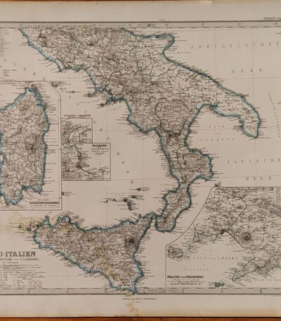
1874, Map of Southern Italy
80,00 €1874, Map of Southern Italy It is a copper engraving made by Jungmann for Stieler, published in Gotha by Justus Perthes in 1874.
This detailed map shows the regions of Naples, Sardinia, Palermo and the Strait of Messina, and is part of the work Hand Atlas by A. Stieler.
- Sheet size: cm. 38×46 approx.
- Engraving size: cm. 33×40 approx.
- Support: Paper
- Condition: Good condition, with a light damp stain in the lower corner
The map features contemporary contour colouring, which enhances its historical and artistic value.
Bay, Pozzuoli, Christopher Weigel, 1719
Bay, Pozzuoli It is an engraving made by Christopher Weigel In the 1719, which represents the famous town of Pozzuoli in Campania.
This work is an example of an original copper engraving, with beautiful colouring contemporary with the watercolour, which enhances the details.
- Sheet size: cm. 37,5×28,5 approx.
- Support: Laid paper with watermark
- Condition: Good condition, with some stains on the front and back and a thin, almost invisible lesion at the bottom
Benedetto Marzolla, Map of Naples, 1845
120,00 €Naples Map It is a lithograph made by Benedict Marzolla in 1845.
This detailed outline map of Naples was constructed using the most recent and accurate materials of the time, highlighting all postal, rolling stock and railway roads.
- Sheet size: cm. 46×23 approx.
- Support: Lightweight paper with white backing
- Condition: Good condition, with editorial creases and some sporadic stains
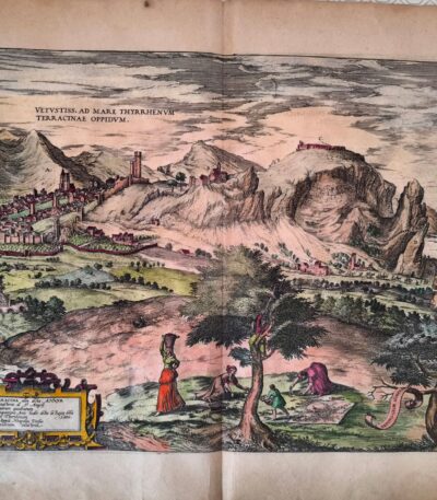
Braun, Georg & Hogenberg Terracina Civitates Orbis Terrarum di Abraham Ortelius 1578
280,00 €BRAUN, Georg & HOGENBERG, Frans
Titolo: Terracina
Tratta da: Civitates Orbis Terrarum, a cura di Abraham Ortelius
Luogo di pubblicazione: Colonia, 1578
Tecnica: Incisione in rame (acquaforte) acquarellata in epoca successiva
Supporto: Carta vergellata
Dimensioni: cm 42 × 54 circa
Condizioni: Ottime, con piccola riparazione professionale al verso sugli angoli superiori
Description:
Rara e magnifica veduta prospettica della città di Terracina, realizzata nel 1578 da Georg Braun e Frans Hogenberg, tra i maggiori incisori e cartografi del Rinascimento. L’opera è tratta dal celebre atlante Civitates Orbis Terrarum, compilato sotto la direzione di Abraham Ortelius, considerato il primo vero atlante urbano del mondo, e pubblicato a Colonia tra il 1572 e il 1617.
La mappa è una straordinaria fusione tra arte e scienza cartografica, in cui la rappresentazione architettonica e paesaggistica è resa con grande attenzione al dettaglio. Terracina è raffigurata con edifici, mura, porti e colline circostanti, offrendo una visione storica impareggiabile dell’assetto urbano del tempo.
Colorata a mano in epoca successiva, con tonalità armoniose e rispettose dei modelli cinquecenteschi, la stampa conserva margini generosi e si presenta in ottime condizioni generali.
Note: Il Civitates Orbis Terrarum fu concepito come complemento al Theatrum Orbis Terrarum di Ortelius, il primo atlante moderno. L’opera documenta la topografia urbana europea e mediterranea, divenendo una fonte primaria per la storia dell’urbanistica e della cartografia rinascimentale.
Esemplare ricercato e perfetto per collezionisti, studiosi e istituzioni.
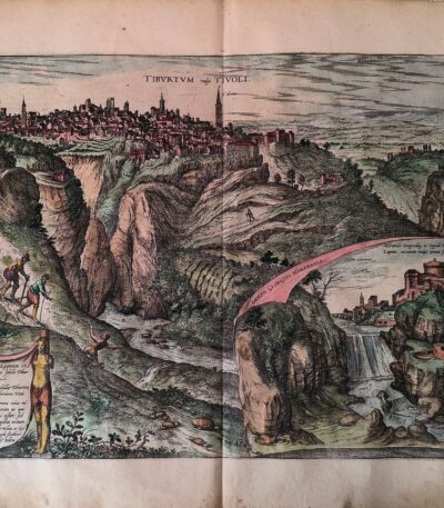
Braun, Georg & Hogenberg, Tibur (Tivoli) da Civitates Orbis Terrarum 1578
280,00 €BRAUN, Georg & HOGENBERG, Frans
Titolo: Tibur (Tivoli)
Tratta da: Civitates Orbis Terrarum
Luogo di pubblicazione: Colonia, 1578
Tecnica: Incisione in rame (acquaforte), acquarellata in epoca successiva
Supporto: Carta vergellata con filigrana (non identificata)
Dimensioni: cm 42 × 54 circa
Condizioni: Ottime. Lievi riparazioni professionali al verso sugli angoli superiori, non invasive, senza alcun impatto sull’immagine incisa.
Description:
Splendida veduta prospettica della città di Tivoli, anticamente conosciuta come Tibur, realizzata nel 1578 da Georg Braun e Frans Hogenberg, fra i principali protagonisti della cartografia urbana del Rinascimento. L’opera è tratta dal celebre Civitates Orbis Terrarum, considerato il primo atlante urbano illustrato del mondo, nato come complemento al Theatrum Orbis Terrarum di Ortelius.
L’incisione rappresenta Tivoli con straordinaria accuratezza topografica e una raffinata sensibilità artistica, offrendo una preziosa testimonianza visiva della città nel XVI secolo: sono visibili i principali edifici, le mura e il paesaggio collinare circostante, disegnati con cura minuziosa.
Colorata a mano in epoca successiva, la stampa conserva tonalità armoniche che esaltano i volumi e l’articolazione urbana. Margini ampi e stato di conservazione eccellente, con interventi minimi e invisibili sul verso.
Note: Le vedute contenute nel Civitates Orbis Terrarum sono fra i più importanti documenti della geografia storica rinascimentale. Questa tavola, dedicata a Tivoli, è una delle più ricercate per il valore storico, estetico e documentario.
Pezzo raro e di grande fascino, adatto a collezionisti, studiosi o esposizioni museali.
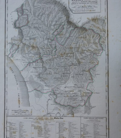
Map of the Duchy of Lucca, 1842
90,00 €Map of the Duchy of Lucca It is an engraving made in 1842, which represents the territory of Lucca during Roman rule and in the Middle Ages.
This work is a physical, historical and statistical chorography of Italy and its islands, created by Attilio Zuccagni-Orlandini.
- Sheet size: cm. 45×62
- Engraving size: cm. 45×62
- Support: Thick engraving paper
- Condition: Perfect state of preservation
- Technique: Etching finished with a burin
This detailed map offers a historical overview of the city of Lucca and its surroundings.
Map of the Port of Syracuse, 1889
20,00 €Map of the Port of Syracuse it's a woodblock print made in 1889.
This work is taken from the volume Naples and Sicily by Jules Gourdault, published in Paris by Libraire Hachette.
- Sheet size: cm. 12×14 approx.
- Condition: Excellent
- Support: Paper
The print was cut from the book and features a printed back.
Map of Southern Italy, 1870
30,00 €Map of Southern Italy It is a copper engraving colored around the outline, made around 1870.
This decorative map depicts southern Italy in great detail, making it a fascinating piece for collectors and cartography enthusiasts.
- Sheet size: cm. 26×20 approx.
- Support: Lightweight paper with white backing
- Condition: Excellent condition
Explore the fascinating world of antique prints
Antique prints are silent witnesses of history, capable of transporting us to distant eras through the art of engraving. Our e-commerce offers a vast selection of these precious finds, carefully selected for their authenticity and artistic value. Whether you are an expert collector or a novice enthusiast, you will find unique pieces here that will enrich your spaces with a touch of timeless elegance.
A safe and rewarding shopping experience
We understand the importance of each individual print and are committed to ensuring a flawless purchasing experience. Our secure payment system and insured shipping with professional packaging ensure that each piece arrives in the best condition. Our expertise in the sector allows us to offer detailed descriptions and personalized advice, helping you to make informed choices. If you have any questions or specific requests, do not hesitate to contact us: we will be happy to guide you into the wonderful world of antique prints.