
Paper

Map of South America, 1869
60,00 €Mappa del Sudamerica è una litografia acquarellata realizzata nel 1869.
This map, part of the volume Hand – Und Schulatlas uber alle Theile Der Erde, presents a sheet size of mm. 437×347 and a white back.
- Sheet size: Great
- Technique: Lithography
- Condition: Excellent
- Support: Strong paper
- Characteristics: Editorial fold
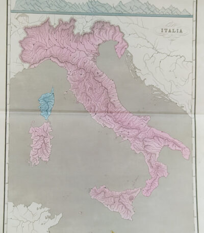
Mappa dell’Italia, 1865
60,00 €Mappa dell’Italia, realizzata nel 1865, è una carta geografica di grande interesse storico.
Drawn by Naymiller and engraved by Allodi, this map is from theAtlas of Universal Geography Chronological, Historical, Statistical and Literary by Francesco Pagnoni, published in Milan in 1865.
- Sheet size: cm. 49×38 approx.
- Map dimensions: cm. 40×32 approx.
- Support: Paper
- Condition: Buona conservazione
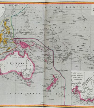
Mappa dell’Oceania, 1865
60,00 €Mappa dell’Oceania è una carta geografica acquarellata realizzata nel 1865.
Drawn by Naymiller and engraved by Allodi, this map is from theAtlas of Universal Geography Chronological, Historical, Statistical and Literary by Francesco Pagnoni, published in Milan.
- Sheet size: cm. 49×38 approx.
- Map dimensions: cm. 40×32 approx.
- Support: Paper
- Condition: Excellent

Map of Africa, 1869
60,00 €Map of Africa It is a watercolour lithograph made in 1869.
This map, part of the volume Hand – Und Schulatlas uber alle Theile Der Erde, has a sheet size of 437x347 mm.
- Sheet size: mm. 437×347
- Technique: Watercolor lithograph
- Support: Strong paper
- Condition: Excellent condition
- Back: White
- Special features: Editorial fold
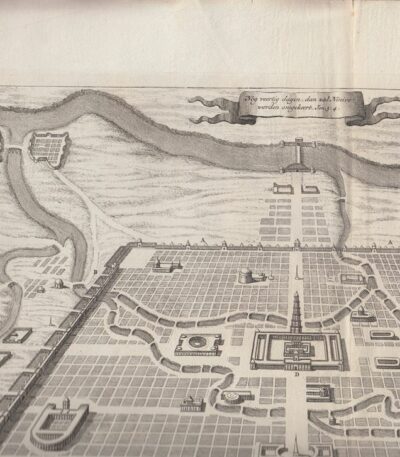
Mappa della città di Ninive, 1650 ca
40,00 €Mappa della città di Ninive è un’incisione realizzata da Diodoro Siculo, datata circa 1650.
Questa mappa rappresenta la città di Ninive secondo le descrizioni di Diodoro Siculo e del famoso erudito E.P. Kircherus.
- Sheet size: cm. 46×38 circa
- Engraving size: cm. 43×30 approx.
- Technique: Etching
- Support: Carta spessa vergellata senza filigrana
- Condition: Excellent condition

Map of Europe 1869
60,00 €Map of Europe 1869 it is a valuable one chromolithography representing the European continent in a detailed format.
This map is taken from the work Hand – Und Schulatlas uber alle Theile Der Erde, published in 1869.
- Sheet size: mm. 437×347
- Support: Strong paper
- Condition: Excellent condition
- Notes: White back, editorial fold
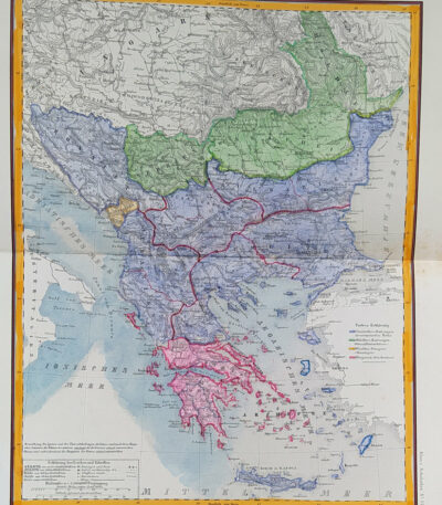
Map of Eastern Europe, 1869
60,00 €Map of Eastern Europe It is a watercolour lithograph made in 1869, which represents Turkey, Bulgaria, Bosnia and Greece.
This map is taken from the volume Hand – Und Schulatlas über alle Teile Der Erde and is characterized by an editorial fold.
- Sheet size: mm. 437×347
- Support: Strong paper
- Condition: Excellent condition
- Back: White

Map of France, 1869
60,00 €Map of France It is a watercolour lithograph made in 1869, which offers a detailed representation of the French territory.
This map is taken from the volume Hand – Und Schulatlas über alle Teile Der Erde, and is characterized by an editorial fold.
- Sheet size: mm. 437×347
- Support: Strong paper
- Condition: Excellent condition
- Back: White

Map of Germany, 1869
60,00 €Map of Germany è una litografia acquarellata risalente al 1869.
This map, part of the volume Hand – Und Schulatlas uber alle Theile Der Erde, features accurate details and vivid coloring.
- Sheet size: mm. 437×347
- Support: Strong paper
- Condition: Excellent condition
- Characteristics: White back, editorial fold

Map of Germany, 1869
60,00 €Map of Germany è una litografia acquarellata del 1869, che rappresenta in modo dettagliato il territorio tedesco.
This map is taken from the volume Hand – Und Schulatlas uber alle Theile Der Erde, and is characterized by an editorial fold.
- Sheet size: mm. 437×347
- Support: Strong paper
- Condition: Excellent condition
- Back: White

Map of Germany, 1869
60,00 €Map of Germany It is a watercolour lithograph made in 1869, which offers a detailed representation of the German territory.
This map is taken from the volume Hand – Und Schulatlas über alle Teile Der Erde, a reference work of the time.
- Sheet size: mm. 437×347
- Support: Strong paper
- Condition: Excellent condition
- Characteristics: White back, editorial fold

Map of Germany, 1869
60,00 €Map of Germany it is a precious one chromolithography built in 1869.
This map, part of the volume Hand – Und Schulatlas uber alle Theile Der Erde, features accurate details and vivid coloring.
- Sheet size: mm. 437×347
- Condition: Excellent
- Support: Strong paper, white back
- Characteristics: Editorial fold

Map of Great Britain, 1869
60,00 €Map of Great Britain It is a watercolour lithograph made in 1869, which represents England, Scotland and Ireland in detail.
This map is taken from the volume Hand – Und Schulatlas uber alle Theile Der Erde and is presented with an editorial twist.
- Sheet size: mm. 437×347
- Support: Strong paper
- Condition: Excellent condition
- Back: White
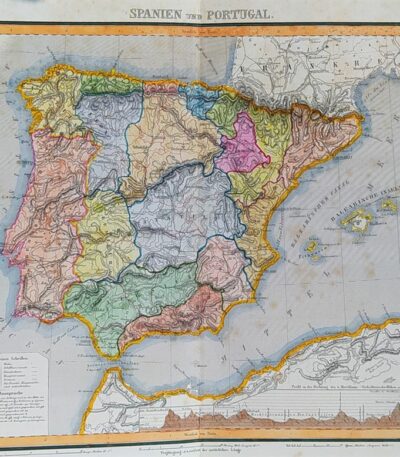
Map of Spain and Portugal, 1869
60,00 €Map of Spain and Portugal It is a watercolour lithograph from 1869, which represents the Iberian territories in detail.
This map is taken from the volume Hand – Und Schulatlas uber alle Theile Der Erde and is presented with an editorial twist.
- Sheet size: mm. 437×347
- Support: Strong paper
- Condition: Excellent condition

Mappa della Svezia, 1869
60,00 €Mappa della Svezia è una litografia acquarellata realizzata nel 1869, che rappresenta la Svezia, la Norvegia e la Danimarca.
This map is taken from the volume Hand – Und Schulatlas uber alle Theile Der Erde e presenta un retro bianco con una piega editoriale.
- Sheet size: mm. 437×347
- Technique: Lithography
- Condition: Excellent
- Support: Strong paper

Mappa di Perpignan, Francia, da Cosmografia di S.Munster, 1614
Map of Perpignan, France It is a woodcut made by Sebastian Munster in 1614, taken from his work Cosmography Universalis.
This map features the historic city of Perpignan, capital of the Pyrénées-Orientales department and once capital of the County of Roussillon.
- Sheet size: cm. 36×22 approx.
- Image size: cm. 12.5x15.5 approx.
- Support: Laid paper
- Condition: Excellent state of preservation
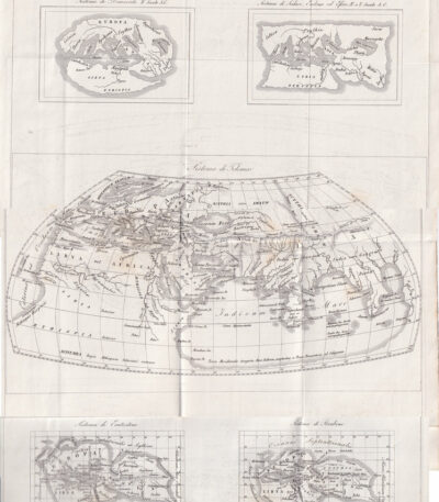
Maps of Europe, 1846
50,00 €Mappe dell’Europa è un’incisione in rame del 1846, che presenta una serie di mappe storiche dell’Europa, tra cui i sistemi di Democrito, Scilace, Eudosso, Eforo, Tolomeo ed Eratostene.
This work is taken from the Storia Universale di Cesare Cantù, pubblicata a Torino presso gli Editori Giuseppe Pomba & C.
- Sheet size: cm. 42×27 circa
- Technique: Copper engraving
- Condition: Buone condizioni con varie pieghe editoriali
- Support: Paper
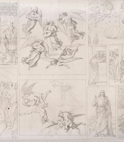
Masaccio, Botticelli, Signorelli, Bellini, Giorgione, 1850
20,00 €Masaccio, Botticelli, Signorelli, Bellini, Giorgione It is a copper engraving made in 1850.
This work is taken from the Bilder-Atlas, published in Leipzig by FA Brockhaus.
Le didascalie sono in tedesco e presentano una selezione di varie pitture di artisti rinomati come Masaccio, Filippo Lippi, Botticelli, Signorelli, Bellini e Giorgione.
- Sheet size: mm. 300×220
- Support: Lightweight paper, white back
- Condition: Excellent condition
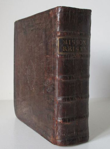
Maximilian Misson, Nouveau voyage d'Italie, 1724
900,00 €Maximilian Misson, Nouveau voyage d’ltalie è un’opera pubblicata nel 1724, che rappresenta una delle più importanti guide di viaggio per l’Italia del suo tempo.
Questo volume, tradotto dall’originale francese, è arricchito da 49 incisioni in rame parzialmente pieghevoli e da immagini nel testo.
- Author: Francis Maximilian Misson (ca. 1650-1722)
- Place of publication: Utrecht
- Publisher: Willem van Water/Jacob van Poolsum
- Characteristics: Titoli in rosso e nero, due frontespizi allegorici di J. Goeree
- Condition: Excellent
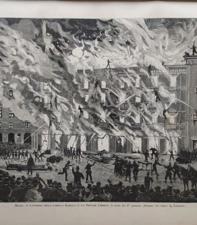
Milano, incendio della fabbrica di Robbiati, il 17 gennaio, 1884
30,00 €Milano, incendio della fabbrica di Robbiati, il 17 gennaio, 1884 It is a woodcut extracted from The Italian Illustration del 1884, pubblicata dai Fratelli Treves Editori di Milano.
Questa opera rappresenta un importante evento storico e verrà spedita il foglio intero contenente la stampa, che presenta scritte al verso.
- Sheet size: cm. 25×35 approx.
- Support: Paper
- Condition: Excellent state of preservation

Mitelli Giuseppe Maria, Arts and Crafts on the Street, Knife Grinder, 1660
120,00 €Knife grinder It is an engraving made by Joseph Maria Mitelli In the 1660, inspired by the theme of the Arts and Crafts on the Street.
This work is taken from THE ARTS BY WAY DRAWN, AND OFFERED […] TO THE GREAT AND TALL GIANT NEPTUNE MR. OF THE BOLOGNA SQUARE.
- Sheet size: cm. 43×31 approx.
- Engraving size: cm. 27×19 approx.
- Technique: Etching
- Support: Thick laid paper
- Condition: Good condition
The engraving is signed lower left with CM. Mitelli Inv. and to the right F.Curti does.
Below the marginal line are four lines of verse about the trade represented.
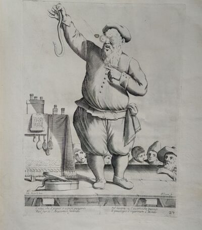
Mitelli Giuseppe Maria, Arts and Crafts on the Street, Charlatan, Barker, 1660
120,00 €Arti e Mestieri per la via, Ciarlatano, Imbonitore It is an engraving made by Joseph Maria Mitelli In the 1660.
This work is taken from L’Arti per via disegnate, et offerte al Grande et Alto Nettuno Gigante, un’opera dedicata alla piazza di Bologna.
- Sheet size: cm. 43×31 approx.
- Engraving size: cm. 27×19 approx.
- Technique: Etching
- Support: Thick laid paper
- Condition: Good condition
L’incisione è firmata in basso a sinistra con ‘CM. Mitelli Inv.’ e a destra ‘F.Curti fe’. Al di sotto della linea marginale, sono presenti quattro righe in versi sul mestiere rappresentato.
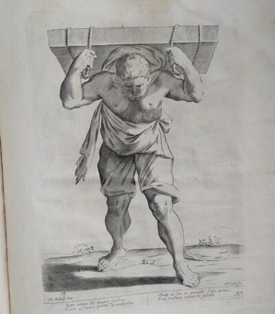
Mitelli Giuseppe Maria, Arts and Crafts on the Street, Porter, 1660
120,00 €Arts and Crafts on the Street, Porter It is an engraving made by Joseph Maria Mitelli In the 1660, inspired by the works of Hannibal Carracci.
This work is part of the series THE ARTS BY WAY DRAWN, AND OFFERED TO THE GREAT AND TALL GIANT NEPTUNE MR. OF THE BOLOGNA SQUARE.
- Sheet size: cm. 43×31 approx.
- Engraving size: cm. 27×19 approx.
- Support: Thick laid paper
- Condition: Good condition
The engraving is signed lower left with CM. Mitelli Inv. and to the right F. Curti doesBelow the marginal line are four lines of verse about the trade depicted.

Mitelli Giuseppe Maria, Arts and Crafts on the Street, Greengrocer Selling Fruit to a Child
120,00 €Arts and Crafts on the Street It is an engraving made by Joseph Maria Mitelli In the 1660, ispirata ai temi della vita quotidiana.
Questa opera rappresenta un fruttivendolo che vende frutta a un bambino, un’immagine che cattura l’essenza del commercio e della vita di strada dell’epoca.
- Sheet size: cm. 43×31 approx.
- Engraving size: cm. 27×19 approx.
- Technique: Etching
- Support: Thick laid paper
- Condition: Good condition
