
Paper

Mitelli Giuseppe Maria, Arts and Crafts on the Street, Butcher's Boy, 1660
120,00 €Garzone di Macellaio It is an engraving made by Joseph Maria Mitelli In the 1660, part of the series Arts and Crafts on the Street, ispirata ai disegni di Hannibal Carracci.
Questa opera è un’acquaforte di dimensioni significative, con un’immagine di cm. 27×19 e un foglio di cm. 43×31, stampata su carta vergellata spessa.
- Sheet size: cm. 43×31 approx.
- Engraving size: cm. 27×19 approx.
- Technique: Etching
- Condition: Good condition
- Support: Laid paper
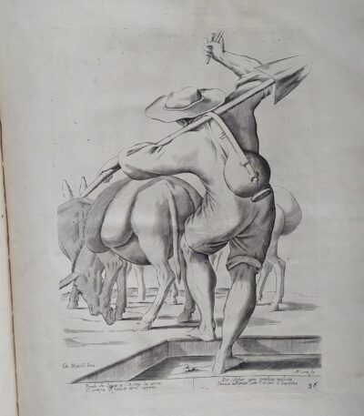
Mitelli Giuseppe Maria, Arts and Crafts on the Street, Donkey Herder, 1660
120,00 €Guardiano di asini It is an engraving made by Joseph Maria Mitelli In the 1660, part of the series Arts and Crafts on the Street, ispirata ai disegni di Hannibal Carracci.
This work is an etching that measures cm. 27×19 alla battuta del rame, su un foglio di carta vergellata spessa di cm. 43×31.
- Signed: bottom left CM. Mitelli Inv. and on the right F.Curti fe.
- Verses: Below the marginal line are four lines of verse about the trade represented.
- Condition: Good condition.
Bibliography: The engravings of Giuseppe Maria Mitelli: critical catalogue, p. 50, 1940.

Mitelli Giuseppe Maria, Arts and Crafts on the Street, Painter, 1660
120,00 €Arti e Mestieri per la via – Imbianchino It is an engraving made by Joseph Maria Mitelli In the 1660, inspired by the works of Hannibal Carracci.
This work is an etching that measures cm. 27×19 alla battuta del rame, su un foglio di carta vergellata spessa di cm. 43×31.
Firmata in basso a sinistra con CM. Mitelli Inv. and to the right F.Curti fe., l’incisione presenta anche quattro righe in versi sul mestiere rappresentato, situate al di sotto della linea marginale.
- Sheet size: cm. 43×31 approx.
- Engraving size: cm. 27×19 approx.
- Support: Laid paper
- Condition: Good condition

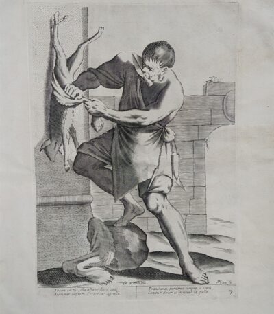
Mitelli Giuseppe Maria, Arts and Crafts on the Street, Pork Butcher, 1660
120,00 €Macellaio di maiale It is an engraving made by Joseph Maria Mitelli nel 1660, parte della serie Arts and Crafts on the Street.
Questa opera, che rappresenta un mestiere tradizionale, è caratterizzata da un’acquaforte di alta qualità.
- Sheet size: cm. 43×31 approx.
- Engraving size: cm. 27×19 approx.
- Support: Thick laid paper
- Condition: Good condition
The engraving is signed lower left with CM. Mitelli Inv. and to the right F.Curti does. Al di sotto della linea marginale, si trovano quattro righe in versi che descrivono il mestiere rappresentato.
Mitelli Giuseppe Maria, Arts and Crafts on the Street, Butcher, 1660
120,00 €Arti e Mestieri per la via, Macellaio It is an engraving made by Joseph Maria Mitelli In the 1660.
This work is part of the series L’Arti per via disegnate, et offerte al grande et alto Nettuno gigante Sig. della Piazza di Bologna.
L’incisione, firmata in basso a sinistra con ‘CM. Mitelli Inv.’ e a destra ‘F. Curti fe.’, presenta un testo in versi sul mestiere rappresentato, situato al di sotto della linea marginale.
- Sheet size: cm. 43×31 approx.
- Engraving size: cm. 27×19 approx.
- Support: Thick laid paper
- Condition: Good condition
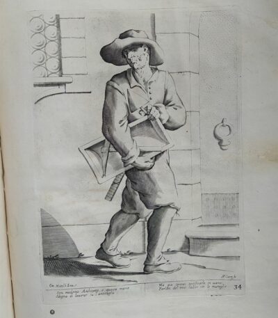
Mitelli Giuseppe Maria, Arts and Crafts for the Street, Bricklayer, 1660
120,00 €Arti e Mestieri per la via, Muratore It is an engraving made by Joseph Maria Mitelli In the 1660, inspired by the works of Hannibal Carracci.
This work is part of the series L’Arti per via disegnate, et offerte al grande et alto Nettuno gigante sig. della piazza di Bologna.
- Sheet size: cm. 43×31 approx.
- Engraving size: cm. 27×19 approx.
- Technique: Etching
- Support: Thick laid paper
- Condition: Good condition
Al di sotto della linea marginale, sono presenti quattro righe in versi sul mestiere rappresentato.
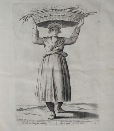
Mitelli Giuseppe Maria, Arts and Crafts on the Street, Greengrocer, Vegetable Seller, 1660
120,00 €Arti e Mestieri per la via, Ortolana, Venditrice di verdura It is an engraving made by Joseph Maria Mitelli In the 1660, inspired by the works of Hannibal Carracci.
This work is part of the series L’Arti per via disegnate, et offerte al grande et alto Nettuno gigante sig. della piazza di Bologna.
- Sheet size: cm. 43×31 approx.
- Engraving size: cm. 27×19 approx.
- Technique: Etching
- Support: Thick laid paper
- Condition: Good condition
The engraving is signed lower left with CM. Mitelli Inv. and to the right F. Curti does. Al di sotto della linea marginale, sono presenti quattro righe in versi sul mestiere rappresentato.
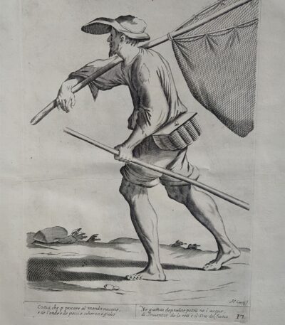
Mitelli Giuseppe Maria, Arts and Crafts on the Street, Fisherman, 1660
120,00 €Arti e Mestieri per la via, Pescatore It is an engraving made by Joseph Maria Mitelli In the 1660, inspired by the works of Hannibal Carracci.
This work is part of the series L’Arti per via disegnate, et offerte al grande et alto Nettuno gigante, dedicata alla rappresentazione dei mestieri.
- Sheet size: cm. 43×31 approx.
- Engraving size: cm. 27×19 approx.
- Technique: Etching
- Support: Thick laid paper
- Condition: Good condition
Below the marginal line are four lines of verse about the trade represented.
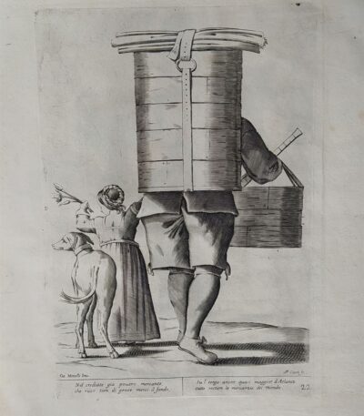
Mitelli Giuseppe Maria, Arts and Crafts for the Street, Grape Carrier for Wine 1660
120,00 €Portatore di uva per il vino It is an engraving made by Joseph Maria Mitelli In the 1660.
This work is part of the series Arts and Crafts on the Street, dedicata ai mestieri tradizionali e rappresenta un portatore di uva, simbolo della cultura vinicola.
- Sheet size: cm. 43×31 approx.
- Engraving size: cm. 27×19 approx.
- Technique: Etching
- Support: Thick laid paper
- Condition: Good condition

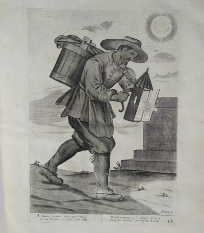
Mitelli Giuseppe Maria, Arts and Crafts on the Street, Well Cleaner, 1660
120,00 €Arti e Mestieri per la via – Pulitore di pozzi It is an engraving made by Joseph Maria Mitelli In the 1660, inspired by the works of Hannibal Carracci.
This work is part of the series L’Arti per via disegnate, et offerte al grande et alto Nettuno gigante, dedicata alla rappresentazione delle professioni dell’epoca.
- Sheet size: cm. 43×31 approx.
- Engraving size: cm. 27×19 approx.
- Technique: Etching
- Support: Thick laid paper
- Condition: Good condition
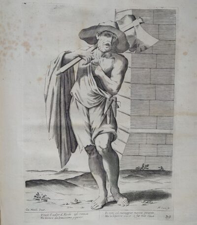
Mitelli Giuseppe Maria, Arts and Crafts on the Street, Wood Splitter, 1660
120,00 €Arts and Crafts for the Street, Log Splitter It is an engraving made by Joseph Maria Mitelli In the 1660, inspired by the works of Hannibal Carracci.
This work, performed in etching, presents an image size of 27x19 cm at the copperplate edge, on a sheet of thick laid paper measuring 43x31 cm.
- Signed: bottom left CM. Mitelli Inv. and on the right F.Curti fe.
- Verses: Below the marginal line are four lines of verse about the trade represented.
- Condition: Good condition.
Bibliography: The engravings of Giuseppe Maria Mitelli: critical catalogue, p. 50, 1940.
Mitelli Giuseppe Maria, Arts and Crafts on the Street, Chimney Sweep, 1660
120,00 €Arti e Mestieri per la via – Spazzacamino It is an engraving made by Joseph Maria Mitelli In the 1660, inspired by the works of Hannibal Carracci.
Questa opera è un’acquaforte che rappresenta un mestiere tradizionale, con una dimensione dell’immagine di cm. 27×19 alla battuta del rame, su un foglio di carta vergellata spessa che misura cm. 43×31.
The engraving is signed lower left with CM. Mitelli Inv. and to the right F.Curti fe.. Al di sotto della linea marginale, sono presenti quattro righe in versi sul mestiere rappresentato.
- Sheet size: cm. 43×31
- Engraving size: cm. 27×19
- Technique: Etching
- Condition: Good
- Support: Laid paper
Mitelli Giuseppe Maria, Arts and Crafts on the Street, Street Vendor, 1660
120,00 €Arts and Crafts on the Street It is an engraving made by Joseph Maria Mitelli nel 1660, ispirata ai lavori di Hannibal Carracci.
This work, part of the series L’Arti per via disegnate, et offerte al grande et alto Nettuno gigante, è firmata in basso a sinistra con CM. Mitelli Inv. and to the right F. Curti fe.
- Sheet size: cm. 43×31 approx.
- Engraving size: cm. 27×19 approx.
- Technique: Etching
- Support: Thick laid paper
- Condition: Good condition
Al di sotto della linea marginale si trovano quattro righe in versi sul mestiere rappresentato.

Mitelli Giuseppe Maria, Arts and Crafts on the Street, Second-hand Clothes Seller with Scales, 1660
120,00 €Arts and Crafts on the Street It is an engraving made by Joseph Maria Mitelli In the 1660, inspired by the works of Hannibal Carracci.
Questa opera, che rappresenta un Venditore di abiti usati con bilancia, è parte della serie L’Arti per via disegnate, et offerte al grande et alto Nettuno gigante sig. della piazza di Bologna.
- Sheet size: cm. 43×31 approx.
- Engraving size: cm. 27×19 approx.
- Technique: Etching
- Support: Thick laid paper
- Condition: Good condition
Al di sotto della linea marginale, sono presenti quattro righe in versi sul mestiere rappresentato.
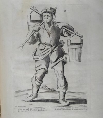
Mitelli Giuseppe Maria, Arts and Crafts on the Street, Rhine Water Seller, 1660
120,00 €Arti e Mestieri per la via, Venditore di acqua del Reno It is an engraving made by Joseph Maria Mitelli In the 1660, ispirata ai temi delle professioni quotidiane.
This work is an etching that measures cm. 27×19 alla battuta del rame, su un foglio di carta vergellata spessa di cm. 43×31.
Firmata in basso a sinistra con ‘CM. Mitelli Inv.’ e a destra ‘F.Curti fe’, l’incisione presenta anche quattro righe in versi sul mestiere rappresentato.
- Sheet size: cm. 43×31 approx.
- Engraving size: cm. 27×19 approx.
- Support: Laid paper
- Condition: Good condition

Mitelli Giuseppe Maria, Arts and Crafts on the Street, Anise and Fireworks Seller, 1660
120,00 €Arts and Crafts on the Street It is an engraving made by Joseph Maria Mitelli In the 1660, ispirata ai mestieri tradizionali.
Questa opera, che rappresenta un Venditore di anice e di fuochi d’artificio, è tratta da L’Arti per via disegnate, et offerte al grande et alto Nettuno gigante, ed è firmata in basso a sinistra con CM. Mitelli Inv. and to the right F. Curti fe.
- Sheet size: cm. 43×31 approx.
- Engraving size: cm. 27×19 approx.
- Support: Thick laid paper
- Condition: Good condition

Mitelli Giuseppe Maria, Arts and Crafts on the Street, Onion Seller, Cipollaro, 1660
120,00 €Venditore di cipolle It is an engraving made by Joseph Maria Mitelli In the 1660, inspired by the theme of the Arts and Crafts on the Street.
This work is taken from THE ARTS BY WAY DRAWN, AND OFFERED TO THE GREAT AND TALL GIANT NEPTUNE MR. OF THE BOLOGNA SQUARE.
- Sheet size: cm. 43×31 approx.
- Engraving size: cm. 27×19 approx.
- Technique: Etching
- Support: Thick laid paper
- Condition: Good condition
The engraving is signed lower left with CM. Mitelli Inv. and to the right F.Curti does. Al di sotto della linea marginale, sono presenti quattro righe in versi sul mestiere rappresentato.

Mitelli Giuseppe Maria, Arts and Crafts on the Street, Cheese Seller, 1660
120,00 €Arti e Mestieri per la via, Venditore di formaggio It is an engraving made by Joseph Maria Mitelli In the 1660, ispirata ai temi della vita quotidiana.
This work is part of the series L’Arti per via disegnate, et offerte al grande et alto Nettuno gigante, che celebra le professioni del tempo.
- Sheet size: cm. 43×31 approx.
- Engraving size: cm. 27×19 approx.
- Technique: Etching
- Support: Thick laid paper
- Condition: Good condition
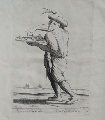
Mitelli Giuseppe Maria, Arts and Crafts on the Street, Seller of Liver Offal, 1660
120,00 €Arti e Mestieri per la via, Venditore di frattaglie di fegato It is a work created by Joseph Maria Mitelli In the 1660, inspired by the works of Hannibal Carracci.
Questa acquaforte presenta una misura dell’immagine di cm. 27×19 alla battuta del rame, su un supporto di carta vergellata spessa che misura cm. 43×31.
L’opera è firmata in basso a sinistra con CM. Mitelli Inv. e a destra con F. Curti fe.. Sotto la linea marginale si trovano quattro righe in versi che descrivono il mestiere rappresentato.
- Era: XVII
- Technique: Etching
- Condition: Good
- Dimensions: Great
- Support: Paper

Mitelli Giuseppe Maria, Arts and Crafts on the Street, Seller of Ribbons, Pins, Needles, 1660
120,00 €Arts and Crafts on the Street It is an engraving made by Joseph Maria Mitelli In the 1660, ispirata ai temi del commercio e dell’artigianato.
Quest’opera, che rappresenta un Venditore di nastri, spille e aghi, è una delle illustrazioni tratte da THE ARTS BY WAY DRAWN, AND OFFERED TO THE GREAT AND TALL GIANT NEPTUNE MR. OF THE BOLOGNA SQUARE.
- Sheet size: cm. 43×31 approx.
- Engraving size: cm. 27×19 approx.
- Support: Thick laid paper
- Condition: Good condition
Mitelli Giuseppe Maria, Arti e Mestieri per la via, Venditore di pere e mele cotte, 1660
120,00 €Arti e Mestieri per la via, Venditore di pere e mele cotte It is an engraving made by Joseph Maria Mitelli In the 1660, ispirata ai temi della vita quotidiana.
Questa opera è un esempio significativo del lavoro di Mitelli, noto per le sue rappresentazioni vivaci e dettagliate delle professioni del suo tempo.
- Sheet size: cm. 43×31 approx.
- Engraving size: cm. 27×19 approx.
- Technique: Etching
- Support: Thick laid paper
- Condition: Good condition
Al di sotto della linea marginale, l’opera presenta quattro righe in versi sul mestiere rappresentato, rendendola non solo un’opera d’arte ma anche un documento culturale.
Bibliography: The engravings of Giuseppe Maria Mitelli: critical catalogue, p. 50, 1940.
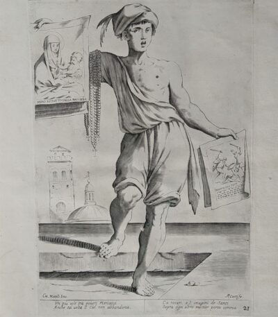
Mitelli Giuseppe Maria, Arti e Mestieri per la via, Venditore di rosari e immagini sacre, 1660
120,00 €Arts and Crafts on the Street It is an engraving made by Joseph Maria Mitelli nel 1660, ispirata ai mestieri tradizionali dell’epoca.
This work, which measures cm. 27×19 alla battuta del rame, è stampata su carta vergellata spessa in size cm. 43×31.
- Technique: Etching
- Condition: Good
- Signed: CM. Mitelli Inv. e F.Curti fe.
- Verses: Quattro righe in versi sul mestiere rappresentato
This work is part of the series THE ARTS BY WAY DRAWN, AND OFFERED […] TO THE GREAT AND TALL GIANT NEPTUNE MR. OF THE BOLOGNA SQUARE.
Bibliography: The engravings of Giuseppe Maria Mitelli: critical catalogue, p. 50, 1940.
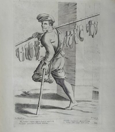
Mitelli Giuseppe Maria, Arti e Mestieri per la via, Venditore di scarpe, 1660
120,00 €Arti e Mestieri per la via, Venditore di scarpe It is an engraving made by Joseph Maria Mitelli In the 1660, ispirata ai mestieri rappresentati da Hannibal Carracci.
This work is part of the series L’Arti per via disegnate, et offerte al grande et alto Nettuno gigante, ed è firmata in basso a sinistra con ‘CM. Mitelli Inv.’ e a destra ‘F. Curti fe’.
- Sheet size: cm. 43×31 approx.
- Engraving size: cm. 27×19 approx.
- Technique: Etching
- Support: Thick laid paper
- Condition: Good condition
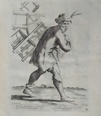
Mitelli Giuseppe Maria, Arts and Crafts on the Street, Chair Seller, 1660
120,00 €Arti e Mestieri per la via, Venditore di sedie It is an engraving made by Joseph Maria Mitelli In the 1660, ispirata ai temi degli artigiani e dei mestieri.
This work is part of the series L’Arti per via disegnate, et offerte al grande et alto Nettuno gigante, un omaggio alla tradizione bolognese.
- Sheet size: cm. 43×31 approx.
- Engraving size: cm. 27×19 approx.
- Support: Thick laid paper
- Condition: Good condition
