
Etching
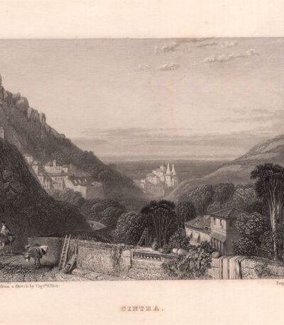
Portugal, Cintra, Sintra, 1833
25,00 €Portugal, Cintra, Sintra It is an etching made in 1833.
This work represents a fascinating glimpse of the city of Sintra, famous for its landscapes and architecture.
- Sheet size: cm. 16×22 approx.
- Engraving size: cm. 9×13 approx.
- Support: Medium thickness paper with white backing
- Condition: Excellent condition

Portugal, Mafra, 1833
25,00 €Portugal, Mafra, 1833 it is an etching made in etching, which represents a work from the first half of the 19th century.
This engraving has an image size of cm. 9×13 on a sheet of paper cm. 16×22, printed on medium-weight paper with white backing.
- Sheet size: cm. 16×22
- Engraving size: cm. 9×13
- Support: Medium thickness paper
- Condition: Excellent condition

Posso aiutarla?, A.H.Payne, 1840-50
20,00 €Posso aiutarla? It is an engraving made by A.H. Payne between 1840 and 1850.
This work, entitled Kann ich dienen?, is an etching on medium-thickness paper, published in Payne's Universum und Buch der Kunst, Leipzig and Dresden.
- Sheet size: cm. 21×27 approx.
- Support: Medium thickness paper
- Condition: Excellent condition
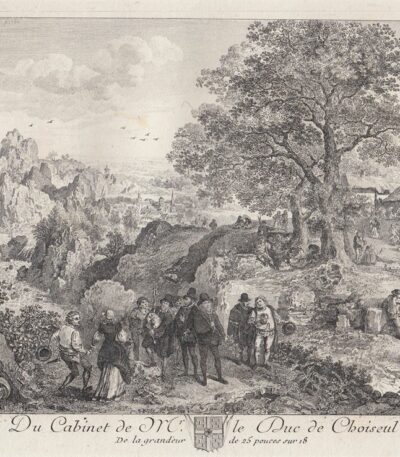
Pourbus, Basan, 1771
30,00 €Cabinet of the Duke of Choiseul It is an engraving made by Pierre-François Basan in 1771.
Questa opera fa parte di un collection of prints che raccoglie le incisioni tratte dai dipinti del cabinet di Monseigneur le Duc de Choiseul.
- Sheet size: cm. 30×20 approx.
- Engraving size: cm. 14×12 approx.
- Technique: Etching
- Support: Laid paper
- Condition: Excellent state of preservation
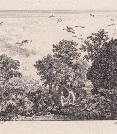
Poussin, Adamo ed Eva, 1809
30,00 €Adam and Eve è un’incisione realizzata da Nicolas Poussin, incisa da De Villiers nel 1809.
Questa opera rappresenta una scena iconica di Adamo ed Eva nel Paradiso, catturando l’essenza della bellezza e della grazia.
- Sheet size: cm. 12×21 circa
- Engraving size: cm. 8×11 approx.
- Technique: Etching
- Support: Laid paper
- Condition: Excellent state of preservation

Pozzuoli, 1840
40,00 €Pozzuoli, 1840 It is an engraving made by C. Frommel, which represents the picturesque city of Pozzuoli.
This work is part of the volume Picturesque Italy, which celebrates Italian beauty and culture through art.
- Sheet size: cm. 15×23 approx.
- Image size: cm. 10×16 approx.
- Support: White backed paper
- Condition: Excellent
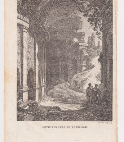
Pozzuoli, Anfiteatro, 1819
25,00 €Pozzuoli, Amphitheatre It is an engraving made by Antoine Laurent Castellan in 1819.
Questa acquaforte rappresenta l’anfiteatro di Pozzuoli ed è stata pubblicata nel volume Letters on Italy, edito a Parigi da A. Nepveu.
- Sheet size: cm. 20×12 approx.
- Engraving size: cm. 14×11 approx.
- Support: Paper
- Condition: Excellent state of preservation
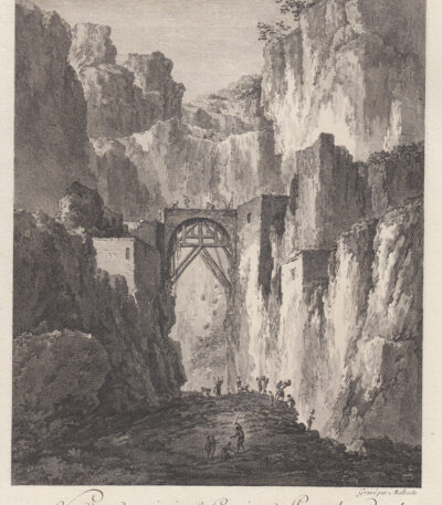
Pozzuoli, Saint-Non, 1781-1786
40,00 €Pozzuoli, Saint-Non, 1781-1786 è un’incisione che rappresenta una vista di una delle principali carriere di pouzzolane.
Realizzata in acquaforte, questa opera misura circa mm. 230×165, con margini irregolari.
It is part of the volume Voyage Pittoresque or Description of the Royal Palaces of Naples and Sicily, scritto e illustrato dall’Abate Jean-Claude Richard de Saint-Non.
- Sheet size: Great
- Technique: Etching
- Condition: Excellent
- Support: Paper
Questa bella veduta è animata e rappresenta un’importante testimonianza del paesaggio napoletano del XVIII secolo.
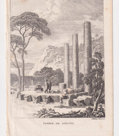
Pozzuoli, Tempio di Serapide, 1819
25,00 €Pozzuoli, Tempio di Serapide è un’incisione realizzata da Antoine-Laurent Castellan nel 1819.
Questa opera è un’acquaforte che rappresenta il famoso Tempio di Serapide, un’importante testimonianza architettonica dell’antichità.
- Sheet size: cm. 20×12 approx.
- Engraving size: cm. 14×11 approx.
- Support: Paper
- Condition: Excellent state of preservation
Castellan, nato a Montpellier nel 1772 e morto a Parigi nel 1838, è stato un rinomato pittore e incisore.
Decorato della Legion d’onore e membro dell’Accademia di Belle Arti, ha realizzato opere soprattutto di paesaggi per libri illustrati come View of Italy And Letters from Italy.
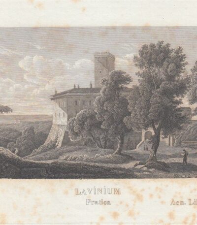
Pratica di Mare, Pomezia, C.Frommel, 1829
25,00 €Pratica di Mare It is an engraving made by Carl Frommel In the 1829, part of the series 50 Bilder zu Virgils Heneide….
This etching su carta presenta un’incisione di dimensioni cm. 7×10, su un foglio di cm. 13×22, con retro bianco.
- Sheet size: cm. 13×22 approx.
- Engraving size: cm. 7×10 approx.
- Support: Paper
- Condition: Excellent state of preservation

Prima della caccia, 1850-60
20,00 €Prima della caccia è un’incisione realizzata tra il 1850 e il 1860, che rappresenta un momento di preparazione per la caccia.
This work is taken from the Art Journal Engraving e fa parte della collezione reale.
- Sheet size: cm. 32×24 approx.
- Engraving size: unspecified
- Support: Strong engraving paper
- Condition: Excellent general condition
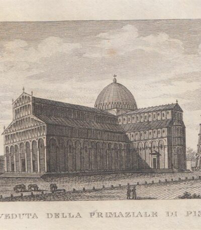
Primaziale di Pisa, 1826
20,00 €Primaziale di Pisa it is an etching on copper made by Antonio Verico in 1826.
This work is taken from the volume Compendium of the Pictorial Journey of Tuscany, published in Florence by Gasparo Ricci.
- Sheet size: cm. 10×17 approx.
- Engraving size: cm. 7×12 approx.
- Support: Paper
- Condition: Excellent state of preservation

Primo amore, 1850
20,00 €Primo Amore It is an engraving made in 1850, taken from the work Art Journal Engraving e proveniente dalla Royal Collection.
This work is made with the technique ofEtching and Burin, su carta forte da incisione.
- Sheet size: cm. 32×24
- Condition: Excellent

Design for a public fountain, AHPayne, 1840-50
20,00 €Progetto di una Fontana Pubblica It is an engraving made by AH Payne between 1840 and 1850.
Questa opera, un design per una fontana pubblica, è eseguita in etching on medium thickness paper.
- Sheet size: cm. 21×27
- Support: Paper
- Condition: Excellent
In basso a destra è presente la firma dell’artista: AHPayne sc.
The press was published in Payne's Universum und Buch der Kunst, Leipzig and Dresden.
Albert Henry Payne, English engraver, designer and publisher, was born in London in 1812 and died in 1902 in Leipzig, where he founded a publishing house, the English Art Institute.

Prove di amore, 1850
20,00 €Prove di amore è un’acquaforte realizzata nel 1850, che cattura una delicata scena ottocentesca.
Questo pezzo rappresenta un esempio significativo dell’arte del XIX secolo, con una composizione che evoca sentimenti di tenerezza e affetto.
- Sheet size: cm. 16×12 approx.
- Technique: Etching
- Condition: Excellent
- Support: Thick paper
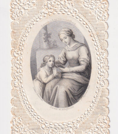
Purezza e semplicità, 1850
20,00 €Purezza e semplicità è un’incisione realizzata nel 1850, che incarna il tema della semplicità e della purezza.
Questa opera è stata pubblicata dalla casa editrice Regnault a Parigi, Francia.
- Sheet size: cm. 6×10 approx.
- Technique: Etching with lace-cut edges
- Condition: Excellent state of preservation
- Support: Paper

Purgatory, Dante, 1757
40,00 €Purgatorio è un’incisione realizzata nel 1757, ispirata alla celebre opera The Divine Comedy by Dante Alighieri.
Questa incisione rappresenta il tema del Purgatorio, con elementi simbolici come il serpente e gli angeli, e riflette i concetti di fede e speranza.
- Sheet size: cm. 28×21 approx.
- Engraving size: cm. 20×13 approx.
- Technique: Etching
- Support: Laid paper
- Condition: Excellent state of preservation
Questa opera è parte di un volume dedicato alla Sagra Imperiale Maestà di Elisabetta Petrowna, Imperatrice di tutte le Russie, pubblicato a Venezia tra il 1757 e il 1758 da Antonio Zatta.

Purgatory, Envy, 1757
40,00 €Purgatorio, Invidia It is an engraving made in 1757, part of the famous work The Divine Comedy by Dante Alighieri, arricchita da annotazioni e decorazioni.
Questa acquaforte, stampata su carta vergellata, presenta un formato di cm. 20×13 alla battuta del rame, su un foglio di cm. 28×21.
- Sheet size: cm. 28×21
- Engraving size: cm. 20×13
- Support: Laid paper
- Condition: Excellent

Quadro dei principali fenomeni Cosmo-Meteorici, 1865
40,00 €Quadro dei principali fenomeni Cosmo-Meteorici, realizzato nel 1865, è una carta meteorologica di grande interesse.
Disegnata da Naymiller e incisa da Allodi, questa opera è tratta dall’Atlas of Universal Geography Chronological, Historical, Statistical and Literary di Francesco Pagnoni, pubblicato a Milano nel 1865.
- Sheet size: cm. 49×38 approx.
- Paper size: cm. 40×32 approx.
- Support: Paper
- Condition: Buona conservazione

Raffaello Sanzio, 1857
30,00 €Raphael Sanzio è un’incisione all’acquaforte originale realizzata nel 1857, tratta dall’Iconoteca Italiana – Collezione di sessanta ritratti d’illustri Italiani, Firenze.
Questa opera misura la battuta di cm. 14×18 su un foglio di cm. 23×32, realizzata su strong paper with white back.
Presenta alcune leggere macchie di ruggine ai bordi, che non interessano l’incisione.
- Sheet size: cm. 23×32
- Engraving size: cm. 14×18
- Support: Strong paper
- Condition: Good

Girl in elegant dress, 1850
60,00 €Ragazza in elegante abito è un pregevole acquerello realizzato nel 1850, che ritrae una giovane ragazza vestita con un elegante abito.
Questo affascinante pezzo d’arte è firmato da Fasfonda, situato al centro in basso.
- Sheet size: cm. 21×13 approx.
- Support: Heavy paper with white backing
- Condition: Excellent condition

Raphael Sadeler, Anub, 1850
40,00 €Anub It is an engraving made by Joannis e Raphael Sadeler In the 1850.
This work is taken from Solitudo sive vitae patrum Eremicolarum, una raccolta che rappresenta la vita degli eremiti.
- Sheet size: cm. 26×42 approx.
- Engraving size: cm. 17×21 approx.
- Technique: Etching
- Support: Medium thickness unlaid paper
- Condition: Excellent

Raphael Sadeler, Piamon, 1850
40,00 €Piamon It is an engraving made by Joannis and Raphael Sadeler in 1850.
This work is taken from Solitudo sive vitae patrum Eremicolarum, una raccolta che illustra la vita degli eremiti, risalente al XVI-XVII secolo.
- Sheet size: cm. 26×42 approx.
- Engraving size: cm. 17×21 approx.
- Technique: Etching
- Support: Medium thickness unlaid paper
- Condition: Excellent
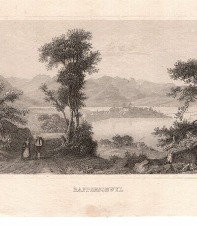
Rapperschwyl, Svizzera, 1850
25,00 €Rapperschwyl, Svizzera It is an engraving made in etching in 1850.
Questa opera rappresenta un affascinante scorcio della Svizzera e misura cm. 7×11 per l’immagine, con margini aggiuntivi.
- Sheet size: Small
- Condition: Excellent
- Support: Medium thickness paper with white backing
