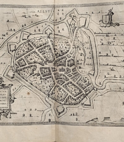
1578, Georg Braun, Frans Hogenberg, map of Alost AAlst Belgium from Civitates Terrarum
140,00 €Alost (Aalst), Belgio, incisione di Georg Braun e Frans Hogenberg, pubblicata nel 1578 come parte del celebre atlante Cities of the Earth's Orb.
Questa splendida mappa rappresenta la città belga di Alost (Aalst) in epoca rinascimentale, evidenziando con grande cura le strutture urbane, i dettagli topografici e i principali edifici storici. L’opera, accompagnata dal contributo editoriale di R. A. Skelton, è un importante esempio dell’arte cartografica del XVI secolo.
- Era: Renaissance (16th century)
- Technique: Etching
- Dimensions: Grandi (cm 42 x 54)
- Support: Laid paper
- Condition: Excellent
Questo pezzo storico, estratto dal volume Cities of the Earth's Orb, costituisce un’aggiunta eccezionale per collezionisti di mappe antiche o per chiunque desideri arricchire la propria collezione con un’opera d’arte dal valore storico e artistico inestimabile.
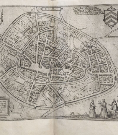
1578, Georg Braun, Frans Hogenberg, map of Lyre Lier Belgium by Ortelius
140,00 €Lyre (Lier, Belgio) è una raffinata mappa incisa all’acquaforte, realizzata da George Brown And Frans Hogenberg In the 1578. Questo capolavoro è tratto dal celebre atlante Cities of the Earth's Orb, una delle prime opere dedicate alla rappresentazione delle città del mondo.
La mappa offre una visione dettagliata della città di Lier, in Belgio, arricchita da elementi decorativi e informazioni storiche. Realizzata su carta vergellata, rappresenta un esempio straordinario dell’arte cartografica rinascimentale.
- Era: 16th century
- Technique: Etching
- Dimensions: Large (cm 42×54)
- Support: Laid paper
- Condition: Excellent condition
Questa mappa è un prezioso documento storico e artistico, perfetto per collezionisti e appassionati di cartografia antica.
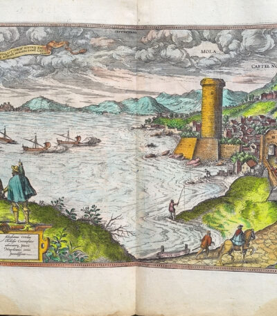
1578, Georg Braun, Frans Hogenberg, watercolor map of Mola Gaeta
280,00 €Gaeta Millstone It is a splendid map made in 1578 by George Brown And Frans Hogenberg, with the editorial contribution of R.A. Skelton.
This engraving, hand-watercoloured, comes from the famous atlas Cities of the Earth's Orb, published under the direction of Abraham Ortelius. The work represents an important cartographic and artistic testimony of the sixteenth century, illustrating in great detail the city and the surrounding territory.
- Era: 16th century
- Technique: Watercolor etching
- Dimensions: Large (cm 42×54)
- Support: Laid paper
- Condition: Very good (minor repairs to upper corners on back)
This map is a piece of great historical and artistic value, ideal for collectors and lovers of ancient cartography.
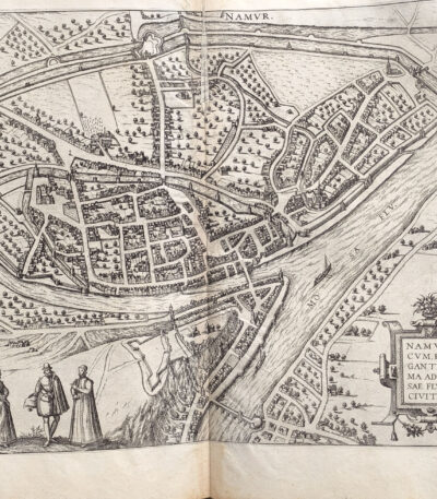
1578, Georg Braun, Frans Hogenberg, map of Namur Belgium from Orbis Terrarum
180,00 €Mappa di Namur, un’incisione storica realizzata da George Brown And Frans Hogenberg In the 1578. Questa stampa fa parte dell’opera monumentale Civitates Orbis Terrarum, una delle più importanti raccolte di vedute urbane del Rinascimento. La mappa rappresenta la città di Namur, in Belgio, con un dettaglio eccezionale, evidenziando l’architettura e la disposizione urbana dell’epoca.
- Era: 16th century
- Technique: Etching
- Dimensions: Large (cm 42×54)
- Support: Laid paper
- Condition: Ottime (riparazione minore al verso con carta)
Un pezzo straordinario, ideale per collezionisti e appassionati di cartografia storica.
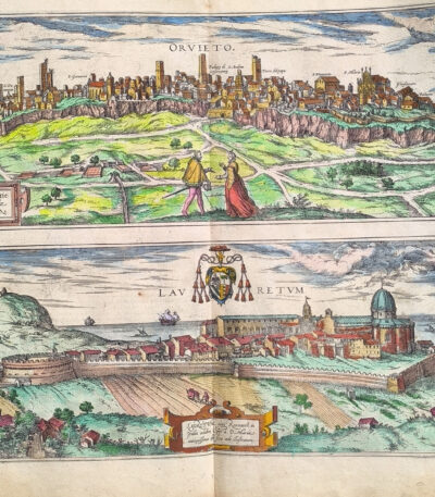
1578, Georg Braun, Frans Hogenberg, watercolor map of Orvieto and Loreto
280,00 €Map of Orvieto and Loreto, made by George Brown, Frans Hogenberg And R.A. Skelton in 1578.
This beautiful print is a fine hand-painted watercolour etching from the famous volume Cities of the Earth's Orb, one of the most important urban atlases of the Renaissance. The work offers a detailed topographical representation of Orvieto and Loreto, capturing the beauty and architectural structure of two historic Italian cities.
- Era: 16th century
- Technique: Watercolor etching
- Dimensions: Large (cm. 42 x 54)
- Support: Laid paper
- Condition: Excellent
This map, in addition to its aesthetic value, represents an important historical testimony, perfect for collectors or enthusiasts of ancient cartography.
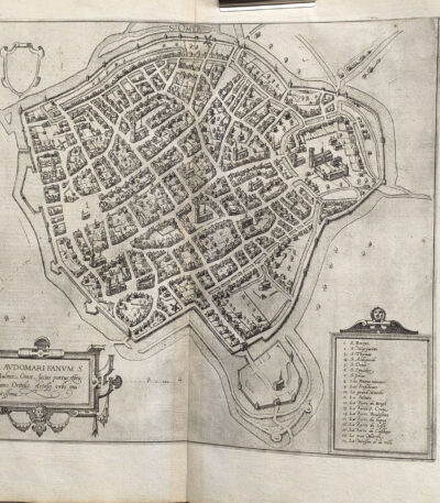
1578, Georg Braun, Frans Hogenberg, map of S. Omer Saudmer France by Ortelius
140,00 €1578, Georg Braun, Frans Hogenberg, mappa di S. Omer Saudmer Francia di Ortelius è un’incisione realizzata da George Brown And Frans Hogenberg In the 1578, tratta dal celebre atlante urbano Cities of the Earth's Orb. Quest’opera, considerata una pietra miliare nella cartografia rinascimentale, offre una rappresentazione dettagliata di quattro città dei Paesi Bassi, mostrando un’elevata precisione geografica e uno stile artistico raffinato.
Il volume, curato da Georg Braun e illustrato da Frans Hogenberg, rappresentava un capolavoro del XVI secolo, concepito per celebrare l’architettura e l’urbanistica delle città più importanti del mondo.
- Era: 16th century
- Technique: Etching
- Dimensions: Large (42×54 cm)
- Support: Laid paper
- Condition: Excellent
Quest’opera si distingue per il suo eccellente stato di conservazione e la qualità del dettaglio, rendendola ideale per collezionisti e appassionati di cartografia storica.
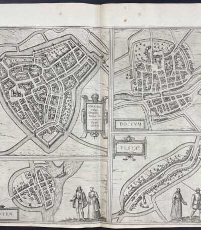
1578, Georg Braun, Frans Hogenberg, map of Sneec Doccum Sloten Ilsten Holland
140,00 €Map of Sneek, Dokkum, Sloten and IJlst, made by George Brown And Frans Hogenberg, with the contribution of R.A. Skelton, In the 1578.
This splendid engraving is part of the famous atlas Cities of the Earth's Orb, one of the most important cartographic works of the 16th century, which offers a detailed representation of the cities and urban centers of the time. The map depicts four cities of Holland, with artistic and geographical details of great historical value.
- Era: 16th century
- Technique: Etching
- Dimensions: Large (42×54 cm)
- Support: Laid paper
- Condition: Excellent
This print is an extraordinary example of Renaissance cartographic mastery, ideal for collectors and lovers of ancient art.
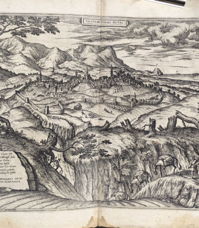
1578, Georg Braun, Frans Hogenberg, map of Velletri from Ortel's Orbis Terrarum
280,00 €Map of Velletri is a splendid engraving created by Georg Braun and Frans Hogenberg in 1578, part of the famous atlas Civitates Orbis Terrarum edited by Abraham Ortelius.
This rare historical view depicts in great detail the city of Velletri in the 16th century, offering a precious testimony of Renaissance cartography.
- Era: 16th century
- Technique: Etching
- Sheet size: cm. 42 x 54 (large format)
- Support: Laid paper
- Condition: Excellent condition
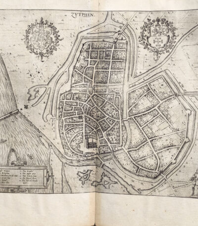
1578, Georg Braun, Frans Hogenberg, map of Zutphen Holland from Orbis Terrarum
180,00 €Zutphen è una mappa storica realizzata da George Brown And Frans Hogenberg, published in 1578 come parte della celebre raccolta Cities of the Earth's Orb, un’opera fondamentale della cartografia rinascimentale. Questo atlante, curato da Braun e illustrato da Hogenberg, offre una rappresentazione dettagliata delle principali città europee, tra cui la città olandese di Zutphen, immortalata in questa incisione.
- Era: 16th century
- Technique: Etching
- Dimensions: Grandi (cm 42×54 circa)
- Support: Laid paper
- Condition: Excellent
Questa stampa è un raro esempio di arte e scienza cartografica dell’epoca, perfetta per collezionisti e appassionati di storia.
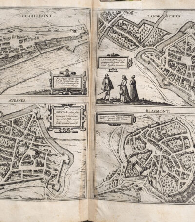
1578, Georg Braun, Hogenberg, maps of Charlemont Landrechies Avesnes Beaumont
180,00 €Charlemont, Landrechies, Avesnes e Beaumont è una magnifica incisione su carta vergellata, realizzata nel 1578 da George Brown And Frans Hogenberg, con contributi successivi di R.A. Skelton.
Questa mappa fa parte del celebre atlante Civitates Orbis Terrarum, curato da Abraham Ortelius, un’opera iconica del Rinascimento che rappresenta le città e i territori più importanti dell’epoca.
- Era: XVI secolo (Rinascimento)
- Technique: Etching
- Dimensions: Large (cm 42×54)
- Support: Laid paper
- Condition: Excellent
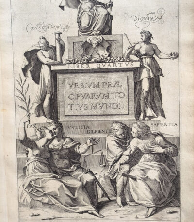
1582, Georg Braun, Frans Hogenberg, Civitates Orbis Terrarum, Frontispiece
140,00 €Urbium Praecipuarum Totius Mundi Liber Quartus
Made by George Brown, Frans Hogenberg And R.A. Skelton In the 1582, this magnificent frontispiece is taken from the famous Civitates Orbis Terrarum, one of the most important works of Renaissance cartography.
The print represents seven allegorical female figures symbolizing the Constance, theHonor, the Dignity, the Peace, the Justice, the Diligence and the Wisdom. These symbols offer a fascinating insight into the ideals of the age.
- Era: Renaissance (16th century)
- Technique: Copper engraving
- Dimensions: Large (approximately 42×27 cm)
- Support: Laid paper
- Condition: Excellent
An iconic work that combines art and history, perfect for collectors and scholars of the Renaissance period
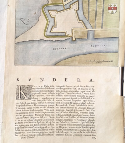
1582, Georg Braun, Frans Hogenberg, map of Kundera Kinderdijk, from Civitates Orbis
80,00 €Kuynder-Schans, incisione di George Brown And Frans Hogenberg, 1582
Questa affascinante stampa, realizzata come acquaforte, è tratta dal celebre atlante Cities of the Earth's Orb, una delle opere cartografiche più importanti del XVI secolo. La mappa raffigura l’insediamento di Kuynder-Schans (oggi Kinderdijk?) nei Paesi Bassi, e combina dettagli artistici e topografici in uno stile tipico dell’epoca.
- Era: XVI secolo (1582)
- Technique: Etching
- Dimensions: Grandi (cm 42 x 27)
- Support: Laid paper
- Condition: Excellent condition
Quest’opera rappresenta un’importante testimonianza della storia cartografica e artistica del Rinascimento, perfetta per collezionisti o appassionati di stampe antiche.
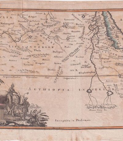
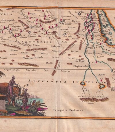
1701, Africa from the Cellarium
60,00 €Africa from Cellario It is a copper engraving made in 1701, taken from the work Notitia Orbis Antiqui sive Geographia Plenior by Christophorus Cellarius.
This map represents a detailed view of Africa and measures cm. 20×30 approximately, on a sheet of cm. 24×33.
- Sheet size: cm. 24×33 approx.
- Engraving size: cm. 20×30 approx.
- Support: Paper
- Condition: Good, with some stains on the edges and editorial creases
1701, Africa, from Cellario Cellarius
60,00 €Africa It is a copper engraving made in 1701, taken from the volume Notitia Orbis Antiqui sive Geographia Plenior by Christophorus Cellarius.
This work offers a detailed representation of the African continent at the time, highlighting the geographical knowledge of the time.
- Sheet size: cm. 24×38 approx.
- Engraving size: cm. 20×35 approx.
- Support: Paper
- Condition: Good, with some stains on the edges and editorial creases
1701, Africa, Map, copper engraving from Cellario
60,00 €Africa, Mappa è un’incisione su rame realizzata da Christophorus Cellarius nel 1701, tratta dal suo celebre lavoro Notitia Orbis Antiqui sive Geographia Plenior.
Questa mappa offre una rappresentazione dettagliata del continente africano dell’epoca, con colori vivaci applicati a mano che ne esaltano la bellezza.
- Sheet size: cm. 24×33 approx.
- Engraving size: cm. 20×30 approx.
- Support: Paper
- Condition: Good, with some stains on the edges
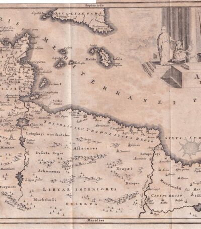
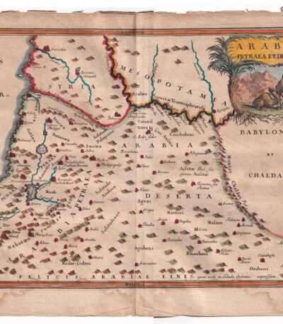
1701, Arabia from the Cellarius
60,00 €Arabia dal Cellario è un’incisione su rame realizzata nel 1701, che rappresenta una mappa dettagliata delle regioni di Arabia, Babilonia e Caldea.
This work is taken from Notitia Orbis Antiqui sive Geographia Plenior by Christophorus Cellarius.
- Sheet size: cm. 24×33 approx.
- Engraving size: cm. 20×30 approx.
- Support: Paper
- Condition: Good, with some stains on the edges
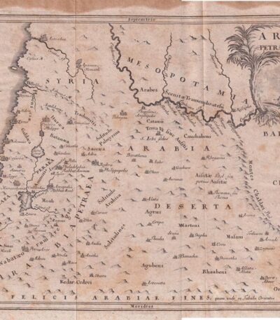
1701, Arabia Map from Cellario
60,00 €1701, Arabia Map from Cellario è un’incisione su rame che rappresenta la regione dell’Arabia, Siria e Mesopotamia.
This map is taken from Notitia Orbis Antiqui sive Geographia Plenior by Christophorus Cellarius, published in 1701.
- Sheet size: cm. 24×33 approx.
- Engraving size: cm. 20×30 approx.
- Support: Paper
- Condition: Good, with some stains on the edges
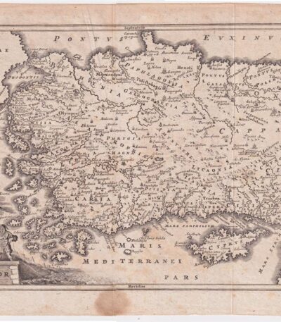
1701, Asia Minor, from the Cellario
60,00 €Asia Minor It is a copperplate map, made in 1701 by Christophorus Cellarius.
This piece is taken from Notitia Orbis Antiqui sive Geographia Plenior, a fundamental work for ancient geography.
- Sheet size: cm. 24×33 approx.
- Engraving size: cm. 20×30 approx.
- Support: Paper
- Condition: Good, with some stains on the edges and editorial creases
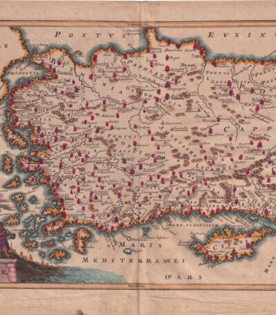
1701, Asia Minor, from the Cellario
60,00 €1701, Asia Minore è una mappa incisa su rame e acquarellata, tratta da Notitia Orbis Antiqui sive Geographia Plenior by Christophorus Cellarius, published in 1701.
Questa incisione, colorata a mano, presenta dimensioni di cm. 20×30 su un foglio di cm. 24×33.
- Sheet size: cm. 24×33 approx.
- Engraving size: cm. 20×30 approx.
- Support: Paper
- Condition: Good, with some stains on the edges
1701, Bosphorus, Albania, Map, copper engraving
60,00 €Mappa del Bosforo, Albania It is a copper engraving made in 1701, taken from the volume Notitia Orbis Antiqui sive Geographia Plenior by Christophorus Cellarius.
Questa mappa, colorata a mano, offre una rappresentazione dettagliata della regione del Bosforo, evidenziando le caratteristiche geografiche dell’epoca.
- Sheet size: cm. 24×33 approx.
- Engraving size: cm. 20×30 approx.
- Support: Paper
- Condition: Good, with some stains on the edges
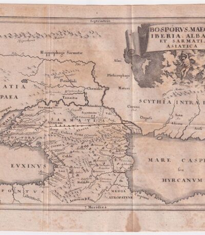
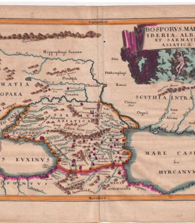
1701, Bosphorus, from the Cellarium
60,00 €1701, Bosforo It is a copper engraving made by Christophorus Cellarius, taken from the work Notitia Orbis Antiqui sive Geographia Plenior published in 1701.
Questa mappa rappresenta le regioni di Iberia, Albania e Sarmazia, offrendo una visione storica e geografica di queste aree.
- Sheet size: cm. 24×33 approx.
- Engraving size: cm. 20×30 approx.
- Support: Paper
- Condition: Buone, con qualche macchia ai margini e alcune pieghe editoriali
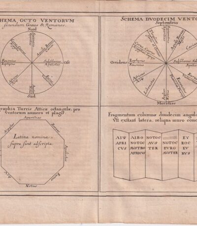
1701, Wind Chart, from the Cellarium
60,00 €1701, Wind Chart It is a copper-engraved map, taken from Notitia Orbis Antiqui sive Geographia Plenior by Christophorus Cellarius, published in 1701.
This engraving offers a detailed representation of the winds, a theme of great importance in ancient geography.
- Sheet size: cm. 24×33 approx.
- Engraving size: cm. 20×30 approx.
- Support: Paper
- Condition: Good, with some stains on the edges and editorial creases

1701, Egypt and Cyrenaica, Map, from the Cellario
70,00 €1701, Egypt and Cyrenaica è una mappa incisa su rame, tratta dal volume Notitia Orbis Antiqui sive Geographia Plenior by Christophorus Cellarius, published in 1701.
Questa mappa, colorata a mano, offre una rappresentazione dettagliata delle regioni storiche dell’Egitto e della Cirenaica.
- Sheet size: cm. 24×33 approx.
- Engraving size: cm. 20×30 approx.
- Support: Paper
- Condition: Good, with some stains on the edges
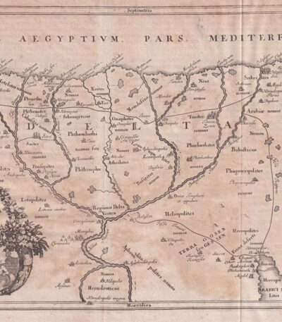
1701, Egypt and the Nile, Cellarius
60,00 €1701, Egypt and the Nile It is a copper engraving made by Christophorus Cellarius, taken from the work Notitia Orbis Antiqui sive Geographia Plenior published in 1701.
This engraving offers a detailed representation of Egypt and the Nile, highlighting the geographical and cultural importance of the region.
- Sheet size: cm. 24×38 approx.
- Engraving size: cm. 20×35 approx.
- Support: Paper
- Condition: Good, with some stains on the edges and editorial creases
