Cartography
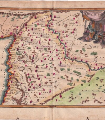
1701, Syria, Map, from the Cellarium
60,00 €Mappa della Siria è un’incisione su rame acquarellata, realizzata nel 1701, tratta da Notitia Orbis Antiqui sive Geographia Plenior by Christophorus Cellarius.
Questa mappa, colorata a mano, presenta dimensioni di cm. 20×30 for engraving and cm. 24×33 for the sheet.
- Sheet size: cm. 24×33 approx.
- Engraving size: cm. 20×30 approx.
- Support: Paper
- Condition: Good, with some stains on the edges
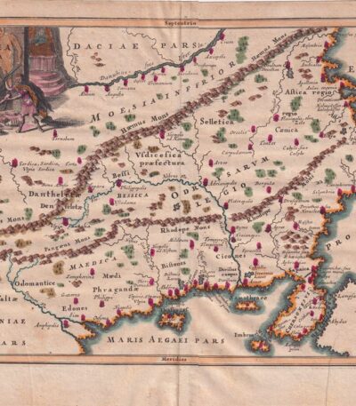
1701, Thrace, Map, from Cellarium
60,00 €Mappa della Tracia è un’incisione su rame acquarellata, realizzata nel 1701 da Christophorus Cellarius.
This piece is taken from Notitia Orbis Antiqui sive Geographia Plenior, a fundamental work for ancient geography.
- Sheet size: cm. 24×33 approx.
- Engraving size: cm. 20×30 approx.
- Support: Paper
- Condition: Buone condizioni con qualche macchia ai margini
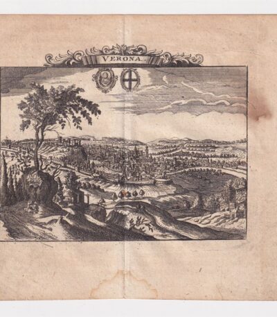
1712, Ancient map of Verona
50,00 €Ancient map of Verona from 1712 is a copper engraving that represents one of the most fascinating historical maps of the city.
This map is taken from the volume The Delights of Italy by De Rogissart and presents accurate details of the Veronese topography of the time.
- Sheet size: cm. 16×17 approx.
- Engraving size: cm. 11×14 approx.
- Support: Light laid paper
- Condition: Excellent state of preservation
- Rarity: Rare
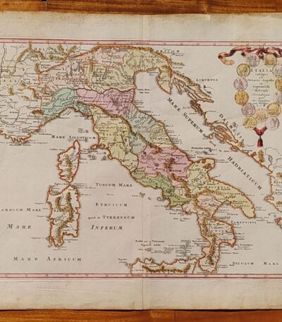
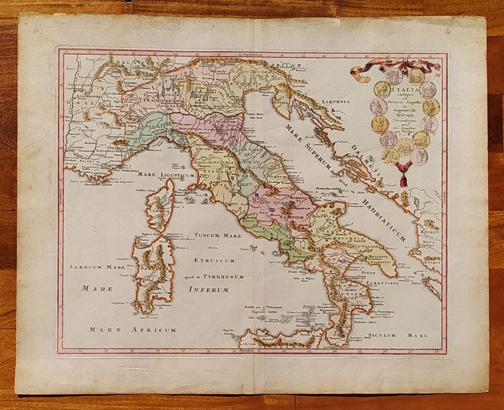
1718, Southern Italy, C.Weigel
220,00 €1718, Southern Italy it's a lithography with contemporary watercolour, made by C. Weigel.
This map represents ancient Italy from Octavian Augustus in Regions XI described.
- Place of publication: Nuremberg
- Year of publication: 1718
- Sheet size: cm. 39×47
- Condition: Excellent, with editorial center fold
- Rarity: Rare representation, with excellent colouring
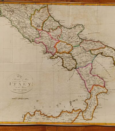
1800, Map of Southern Italy
120,00 €1800, Map of Southern Italy It is a hand-colored lithograph representing The Theater of War in Italy in the years 1797, 1798 and 1799.
This map offers a rare and detailed view of the conflict, with exceptional colouring that enhances the details.
- Sheet size: cm. 38×45
- Condition: Excellent condition
- Technique: Lithography
- Support: Paper

1800, Map of Southern Italy
80,00 €1800, Map of Southern Italy it is a lithograph that represents The Theatre of War in Italy in the years 1797, 1798 and 1799.
This map offers a rare and detailed view of the war context of the time, making it a piece of great historical interest.
- Sheet size: cm. 38×45 approx.
- Technique: Lithography
- Condition: Excellent condition
- Support: Paper

1800, Map of Northern Italy
120,00 €Map of Northern Italy It is a lithograph made in 1800, representing the theatre of war in Italy during the campaigns of 1796 and 1799.
This hand-colored map is a rare historical representation with exceptional coloring.
- Sheet size: cm. 41×65
- Condition: Excellent, with some editorial creases
- Technique: Lithography
- Support: Paper

1800, Map of Northern Italy
80,00 €1800, Map of Northern Italy It is a lithograph representing a detailed map of the theatre of war in Italy during the campaigns of 1796 and 1799.
This rare representation offers a fascinating glimpse into the historical events of that period.
- Sheet size: cm. 41×65
- Condition: Excellent, with some editorial creases
- Support: Paper

1838 Map of Italy and Sicily watercolored by Delamarche
80,00 €Map of Italy and Sicily, by Delamarche, 1838. On unlaid paper of medium thickness, cm.34×48, white back. Colored with watercolours at a later date. Excellent condition.
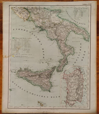
1855, Map of Southern Italy
80,00 €1855, Map of Southern Italy It is a lithograph made by C. Flemming, published in 1855.
This map represents Southern Italy and Sardinia, and was produced by Berghaus, Heinrich and Sohr, Karl.
- Sheet size: cm. 44×37
- Coloration: Contemporary with the outline
- Condition: Excellent condition
- Rarity: Rare representation with excellent coloring
1860, Colored map of Central and Southern Italy
80,00 €1860, Colored map of Central and Southern Italy is a steel engraving published in 1860 by Blackie & Son, London, for The Imperial Atlas of Modern Geography by Walter Graham Blackie.
This map has been hand colored with watercolor and features a central editorial fold.
- Sheet size: cm. 54×37
- Support: Strong paper
- Condition: Excellent condition
The back is white.

1861, Map of Southern Italy
60,00 €1861, Map of Southern Italy It is a historical map representing the regions of Southern Italy, including Sicily, Sardinia and Corsica.
This card was made by Reichard and is part of the volume Ancient Earth Orb, published circa 1861.
- Sheet size: cm. 33×39
- Coloration: Manual
- Condition: Excellent condition
- Rarity: Rare representation with excellent coloring
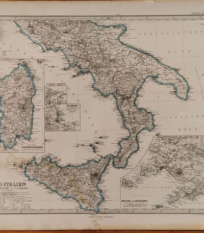
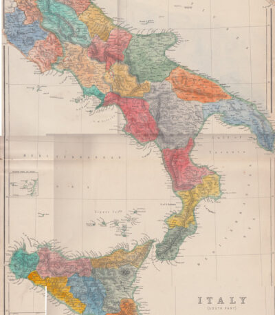
1874, Map of Southern Italy
80,00 €1874, Map of Southern Italy It is a copper engraving made by Jungmann for Stieler, published in Gotha by Justus Perthes in 1874.
This detailed map shows the regions of Naples, Sardinia, Palermo and the Strait of Messina, and is part of the work Hand Atlas by A. Stieler.
- Sheet size: cm. 38×46 approx.
- Engraving size: cm. 33×40 approx.
- Support: Paper
- Condition: Good condition, with a light damp stain in the lower corner
The map features contemporary contour colouring, which enhances its historical and artistic value.

Africa, C.F. Delamarche, 1816
70,00 €Africa It is a copper engraving map made by CF Delamarche in 1816.
This map represents Africa divided into its main states and is taken from the volume Petit Atlas Moderne ou Collection de Cartes Elementaires, dedicated to youth and published in Paris by Delamarche.
- Sheet size: cm. 21×27 approx.
- Technique: Burin
- Condition: Good condition, with some peeling and central editorial crease
- Support: Paper

Africa, Otto Petri, 1853
50,00 €Africa It is a hand-engraved and hand-colored map, made by Otto Petri in 1853.
This map measures cm. 22×27 on a sheet of paper cm. 26×34 and it is printed on medium thickness paper with white back.
It has an editorial fold and is in excellent condition.
The map is taken from the School Atlas Alle Deelen Der Aarde, published by J. Van Den Bosch in Rotterdam.
- Sheet size: cm. 26×34
- Map dimensions: cm. 22×27
- Support: Medium thickness paper
- Condition: Excellent condition

America Meridionale, 1865
60,00 €America Meridionale, 1865 è una carta geografica acquarellata che offre una rappresentazione dettagliata del continente sudamericano.
Drawn by Naymiller and engraved by Allodi, this map is from the work Atlas of Universal Geography Chronological, Historical, Statistical and Literary by Francesco Pagnoni, pubblicata a Milano nel 1865.
- Sheet size: cm. 49×38 approx.
- Paper size: cm. 40×32 approx.
- Support: Paper
- Condition: Buona conservazione

South America, CF Delamarche, 1816
70,00 €South America It is a map engraved by CF Delamarche in 1816, representing South America.
This copper engraving is colored around the outline and is taken from the volume Petit Atlas Moderne ou Collection de Cartes Elementaires, dedicated to youth and published in Paris by Delamarche.
- Sheet size: cm. 21×27 approx.
- Condition: Good condition, with some peeling and a central editorial crease
- Support: Paper

North America, 1865
60,00 €North America It is a watercolour map made in 1865.
Drawn by Naymiller and engraved by Allodi, this map is from the work Atlas of Universal Geography Chronological, Historical, Statistical and Literary by Francesco Pagnoni, published in Milan.
- Sheet size: cm. 49×38 approx.
- Paper size: cm. 40×32 approx.
- Support: Paper
- Condition: Excellent

North America, CF Delamarche, 1816
70,00 €North America It is a copper engraving map colored around the outline, made by CF Delamarche in 1816.
This map is part of the volume Petit Atlas Moderne ou Collection de Cartes Elementaires, published in Paris by Delamarche.
- Sheet size: cm. 21×27 approx.
- Condition: Good condition, with some peeling and a central editorial crease
- Support: Paper

Asia, 1865
60,00 €Asia, 1865 è una carta geografica acquarellata realizzata da Naymiller e incisa da Allodi.
This map is taken from the work Atlas of Universal Geography Chronological, Historical, Statistical and Literary by Francesco Pagnoni, pubblicata a Milano nel 1865.
- Sheet size: cm. 49×38 approx.
- Paper size: cm. 40×32 approx.
- Support: Paper
- Condition: Ottima stato di conservazione

Asia, Otto Petri, 1853
50,00 €Asia è una mappa incisa e colorata a mano realizzata da Otto Petri nel 1853.
This work comes from the School Atlas Alle Deelen Der Aarde, published by J. Van Den Bosch in Rotterdam.
- Sheet size: cm. 26×34 approx.
- Map dimensions: cm. 22×27 approx.
- Support: Medium thickness paper
- Condition: Excellent state of preservation
- Characteristics: White back, editorial fold

Australia, Otto Petri, 1853
50,00 €Australia It is a hand-engraved and hand-colored map, made by Otto Petri in 1853.
This map is part of the School Atlas Alle Deelen Der Aarde, published by J. Van Den Bosch in Rotterdam.
- Sheet size: cm. 26×34 approx.
- Map dimensions: cm. 22×27 approx.
- Support: Medium thickness paper
- Condition: Ottime condizioni, con retro bianco e piega editoriale

Bay, Pozzuoli, Christopher Weigel, 1719
Bay, Pozzuoli It is an engraving made by Christopher Weigel In the 1719, which represents the famous town of Pozzuoli in Campania.
This work is an example of an original copper engraving, with beautiful colouring contemporary with the watercolour, which enhances the details.
- Sheet size: cm. 37,5×28,5 approx.
- Support: Laid paper with watermark
- Condition: Good condition, with some stains on the front and back and a thin, almost invisible lesion at the bottom

Bavaria, St.Munster, 1614
Bavaria, St.Munster, 1614 è una veduta affascinante della Baviera, estratta dalla celebre Cosmography Universalis by Sebastian Munster.
Questa xilografia, realizzata su carta vergellata acquarellata, offre uno sguardo dettagliato sulla regione nel 1614. Sul retro, sono presenti altre immagini che arricchiscono ulteriormente l’opera.
- Sheet size: cm. 36×22 approx.
- Image size: cm. 7×13 approx.
- Support: Watercolored laid paper
- Condition: Excellent
