Cartography

Bellin, Mappa dell’isola di S.Elena, 1750
30,00 €Mappa dell’isola di Sant’Elena è un’incisione realizzata da Bellin nel 1750.
This map, titled Karte von der Bay S.t Helena, offre una rappresentazione dettagliata dell’isola, misurando cm. 21×16 about.
- Sheet size: cm. 21×16 approx.
- Support: Carta vergellata leggera, retro bianco
- Condition: Excellent condition

Benedetto Marzolla, Map of Naples, 1845
120,00 €Naples Map It is a lithograph made by Benedict Marzolla in 1845.
This detailed outline map of Naples was constructed using the most recent and accurate materials of the time, highlighting all postal, rolling stock and railway roads.
- Sheet size: cm. 46×23 approx.
- Support: Lightweight paper with white backing
- Condition: Good condition, with editorial creases and some sporadic stains

Benelux, Otto Petri, 1853
50,00 €Benelux è una mappa incisa a mano da Eight Petri In the 1853, che rappresenta i paesi del Benelux: Olanda, Lussemburgo e Belgio.
Questa incisione colorata è parte del School Atlas Alle Deelen Der Aarde, published by J. Van Den Bosch in Rotterdam.
- Sheet size: cm. 26×34 approx.
- Map dimensions: cm. 22×27 approx.
- Support: Medium thickness paper
- Condition: Excellent condition
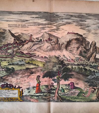
Braun, Georg & Hogenberg Terracina Civitates Orbis Terrarum di Abraham Ortelius 1578
280,00 €BRAUN, Georg & HOGENBERG, Frans
Titolo: Terracina
Tratta da: Civitates Orbis Terrarum, a cura di Abraham Ortelius
Luogo di pubblicazione: Colonia, 1578
Tecnica: Incisione in rame (acquaforte) acquarellata in epoca successiva
Supporto: Carta vergellata
Dimensioni: cm 42 × 54 circa
Condizioni: Ottime, con piccola riparazione professionale al verso sugli angoli superiori
Description:
Rara e magnifica veduta prospettica della città di Terracina, realizzata nel 1578 da Georg Braun e Frans Hogenberg, tra i maggiori incisori e cartografi del Rinascimento. L’opera è tratta dal celebre atlante Civitates Orbis Terrarum, compilato sotto la direzione di Abraham Ortelius, considerato il primo vero atlante urbano del mondo, e pubblicato a Colonia tra il 1572 e il 1617.
La mappa è una straordinaria fusione tra arte e scienza cartografica, in cui la rappresentazione architettonica e paesaggistica è resa con grande attenzione al dettaglio. Terracina è raffigurata con edifici, mura, porti e colline circostanti, offrendo una visione storica impareggiabile dell’assetto urbano del tempo.
Colorata a mano in epoca successiva, con tonalità armoniose e rispettose dei modelli cinquecenteschi, la stampa conserva margini generosi e si presenta in ottime condizioni generali.
Note: Il Civitates Orbis Terrarum fu concepito come complemento al Theatrum Orbis Terrarum di Ortelius, il primo atlante moderno. L’opera documenta la topografia urbana europea e mediterranea, divenendo una fonte primaria per la storia dell’urbanistica e della cartografia rinascimentale.
Esemplare ricercato e perfetto per collezionisti, studiosi e istituzioni.
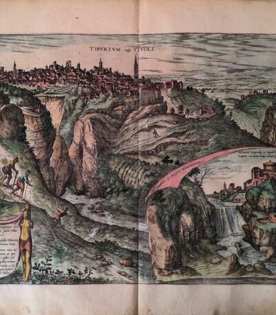
Braun, Georg & Hogenberg, Tibur (Tivoli) da Civitates Orbis Terrarum 1578
280,00 €BRAUN, Georg & HOGENBERG, Frans
Titolo: Tibur (Tivoli)
Tratta da: Civitates Orbis Terrarum
Luogo di pubblicazione: Colonia, 1578
Tecnica: Incisione in rame (acquaforte), acquarellata in epoca successiva
Supporto: Carta vergellata con filigrana (non identificata)
Dimensioni: cm 42 × 54 circa
Condizioni: Ottime. Lievi riparazioni professionali al verso sugli angoli superiori, non invasive, senza alcun impatto sull’immagine incisa.
Description:
Splendida veduta prospettica della città di Tivoli, anticamente conosciuta come Tibur, realizzata nel 1578 da Georg Braun e Frans Hogenberg, fra i principali protagonisti della cartografia urbana del Rinascimento. L’opera è tratta dal celebre Civitates Orbis Terrarum, considerato il primo atlante urbano illustrato del mondo, nato come complemento al Theatrum Orbis Terrarum di Ortelius.
L’incisione rappresenta Tivoli con straordinaria accuratezza topografica e una raffinata sensibilità artistica, offrendo una preziosa testimonianza visiva della città nel XVI secolo: sono visibili i principali edifici, le mura e il paesaggio collinare circostante, disegnati con cura minuziosa.
Colorata a mano in epoca successiva, la stampa conserva tonalità armoniche che esaltano i volumi e l’articolazione urbana. Margini ampi e stato di conservazione eccellente, con interventi minimi e invisibili sul verso.
Note: Le vedute contenute nel Civitates Orbis Terrarum sono fra i più importanti documenti della geografia storica rinascimentale. Questa tavola, dedicata a Tivoli, è una delle più ricercate per il valore storico, estetico e documentario.
Pezzo raro e di grande fascino, adatto a collezionisti, studiosi o esposizioni museali.

Brunswick, St. Munster, 1614
Brunswick, St. Munster, 1614 is a historical view of the city of Braunschweig, located in Lower Saxony, Germany.
This engraving is taken from the famous work Cosmography Universalis by Sebastian Munster, published in Basel in 1614.
- Sheet size: cm. 36×22 approx.
- Engraving size: cm. 12.5×15 approx.
- Support: Laid paper
- Condition: Excellent state of preservation
Map of the Duchy of Lucca, 1842
90,00 €Map of the Duchy of Lucca It is an engraving made in 1842, which represents the territory of Lucca during Roman rule and in the Middle Ages.
This work is a physical, historical and statistical chorography of Italy and its islands, created by Attilio Zuccagni-Orlandini.
- Sheet size: cm. 45×62
- Engraving size: cm. 45×62
- Support: Thick engraving paper
- Condition: Perfect state of preservation
- Technique: Etching finished with a burin
This detailed map offers a historical overview of the city of Lucca and its surroundings.

Map of the Port of Syracuse, 1889
20,00 €Map of the Port of Syracuse it's a woodblock print made in 1889.
This work is taken from the volume Naples and Sicily by Jules Gourdault, published in Paris by Libraire Hachette.
- Sheet size: cm. 12×14 approx.
- Condition: Excellent
- Support: Paper
The print was cut from the book and features a printed back.

Map of Northern Italy, 1834
30,00 €Carta dell’ Italia Settentrionale è un’incisione realizzata da Th. Duvotenay nel 1834.
Questa mappa, che rappresenta la parte settentrionale dell’Italia, è stata incisa in rame a Parigi.
- Engraving size: mm. 232×182
- Margins: almost absent
- Support: Lightweight paper, white back
- Condition: Excellent condition
Si tratta di una bella e decorativa carta dell’Italia Settentrionale, perfetta per collezionisti e appassionati di cartografia.

Map of Northern Italy, 1836
40,00 €Map of Northern Italy è un’incisione in rame realizzata da Th. Duvotenay nel 1836.
Questa carta, parte delle carte routiere de l’Italie, è una rappresentazione dettagliata e decorativa dell’Italia Settentrionale.
- Sheet size: cm. 55×37 circa
- Engraving size: cm. 47×29 circa
- Support: Lightweight paper, white back
- Condition: Excellent

Map of the Barbarian invasion in Europe, 1865
60,00 €Carta dell’invasione dei Barbari in Europa è una mappa storica realizzata nel 1865, disegnata da Naymiller e incisa da Allodi.
Questa carta colorata offre una rappresentazione dettagliata degli eventi storici legati all’invasione dei Barbari in Europa, ed è parte dell’opera Atlas of Universal Geography Chronological, Historical, Statistical and Literary di Francesco Pagnoni.
- Sheet size: cm. 49 x 38 circa
- Paper size: cm. 40 x 32 circa
- Support: Paper
- Condition: Excellent

Map of the Province of Alessandria, 1890
20,00 €Carta della Provincia di Alessandria It is a woodcut print made in 1890 by the engraver Barberis.
Questa opera è un esempio di arte grafica italiana di fine Ottocento, caratterizzata da un’accurata rappresentazione cartografica.
- Sheet size: cm. 14×19 circa
- Support: Retro bianco
- Condition: Excellent

Geographical Map of Piedmont, 1890
30,00 €Carta Geografica del Piemonte it is a woodcut print made in 1890, coming from an Italian text from the late nineteenth century.
Questa mappa offre una rappresentazione dettagliata della regione piemontese, con testo informativo al verso del foglio.
- Sheet size: cm. 30×20 approx.
- Image size: cm. 23×17 approx.
- Support: Paper
- Condition: Excellent

Carta Geografica dell’Umbria, 1890
30,00 €Carta Geografica dell’Umbria è una pregevole stampa xilografica realizzata nel 1890, proveniente da un testo italiano di fine Ottocento.
Questa carta offre una rappresentazione dettagliata della regione umbra, con testo al verso del foglio.
- Sheet size: cm. 30×20 approx.
- Image size: cm. 23×16 approx.
- Technique: Woodcut
- Condition: Excellent
- Support: Paper

Carta Geografica della Basilicata, 1890
30,00 €Carta Geografica della Basilicata it is a woodcut print made in 1890, coming from an Italian text from the late nineteenth century.
Questa carta offre una rappresentazione dettagliata della regione, con testo esplicativo attorno e sul retro del foglio.
- Sheet size: cm. 30×20 approx.
- Image size: cm. 24×17 approx.
- Technique: Woodcut
- Condition: Excellent
- Support: Paper

Carta Geografica della Calabria, 1890
30,00 €Carta Geografica della Calabria it is a woodcut print made in 1890, coming from an Italian text from the late nineteenth century.
Questa carta offre una rappresentazione dettagliata della regione calabrese, con testo descrittivo attorno e al verso del foglio.
- Sheet size: cm. 30×20 approx.
- Image size: cm. 17×24 approx.
- Support: Paper
- Condition: Excellent

Carta Geografica della Campania, 1890
30,00 €Carta Geografica della Campania it is a valuable one woodblock print realizzata nel 1890, che offre una visione dettagliata della regione campana.
Questa opera è tratta da un testo italiano di fine Ottocento e presenta un testo descrittivo attorno all’immagine, oltre a contenere informazioni al verso del foglio.
- Sheet size: cm. 30×20 approx.
- Image size: cm. 24×17 approx.
- Support: Paper
- Condition: Excellent

Carta Geografica delle Marche, 1890
30,00 €Carta Geografica delle Marche it is a woodcut print made in 1890, coming from an Italian text from the late nineteenth century.
Questa carta offre una rappresentazione dettagliata della regione Marche, con testo al verso del foglio.
- Sheet size: cm. 30×20 approx.
- Image size: cm. 22×16 approx.
- Support: Paper
- Condition: Excellent

Carta Italia, Grecia, Macedonia, C.Frommel, 1829
25,00 €Carta Italia, Grecia, Macedonia It is an engraving made by Carl Frommel in 1829.
This work is taken from 50 Bilder zu Virgils Heneide… e presenta un’incisione di alta qualità su carta media.
- Sheet size: cm. 13×22 approx.
- Engraving size: cm. 7×10 approx.
- Support: Paper
- Condition: Excellent state of preservation

Cellarius, Belgium, 1701
60,00 €Cellarius, Belgium, 1701 è una mappa incisione su rame realizzata da Christophorus Cellarius, tratta dal suo lavoro Notitia Orbis Antiqui sive Geographia Plenior.
Questa mappa rappresenta la Gallia Belgica ed è un’importante testimonianza cartografica del XVII secolo.
- Sheet size: cm. 24×33 approx.
- Engraving size: cm. 20×30 approx.
- Support: Paper
- Condition: Excellent

Cellarius, France, 1701
60,00 €Cellarius It is a copper engraving map made in France in 1701, taken from the work Notitia Orbis Antiqui sive Geographia Plenior by Christophorus Cellarius.
This engraving offers a detailed representation of Gaul, highlighting the geographical features of the time.
- Sheet size: cm. 24×33 approx.
- Engraving size: cm. 20×30 approx.
- Support: Paper
- Condition: Excellent state of preservation

Cellarius, Germany, 1701
60,00 €Cellarius, Germany, 1701 It is a copper engraving representing a detailed map, taken from Notitia Orbis Antiqui sive Geographia Plenior by Christophorus Cellarius, published in 1701.
This work offers a fascinating insight into the geography of the period, making it a valuable piece for collectors and history buffs.
- Sheet size: cm. 24×33 approx.
- Engraving size: cm. 20×30 approx.
- Support: Paper
- Condition: Excellent state of preservation

Cellarius, Great Britain, 1701
60,00 €Insularum Britannicarum Facies Antiqua It is a copper-engraved map made by Christophorus Cellarius in 1701, from his work Notitia Orbis Antiqui sive Geographia Plenior.
This engraving provides a detailed representation of the British Isles, reflecting the geography of the period.
- Sheet size: cm. 24×33 approx.
- Engraving size: cm. 20×30 approx.
- Support: Paper
- Condition: Excellent state of preservation

Cellarius, Greece, 1701
60,00 €Cellarius, Grecia è una mappa incisa su rame realizzata nel 1701 da Christophorus Cellarius.
This engraving is taken from the work Notitia Orbis Antiqui sive Geographia Plenior, pubblicata nel 1701.
- Sheet size: cm. 24×33 approx.
- Engraving size: cm. 20×30 approx.
- Support: Paper
- Condition: Excellent
