Cartography

Map of Russia, 1821
25,00 €Map of Russia It is a watercolour copper engraving dating back to 1821.
This small geographical map, measuring approximately 9x9 cm, is printed on a 13x15 cm sheet, with a white back.
The work is taken from a French text of the time and is presented in excellent condition.
- Sheet size: cm. 13×15 approx.
- Engraving size: cm. 9×9 approx.
- Support: Paper
- Condition: Excellent
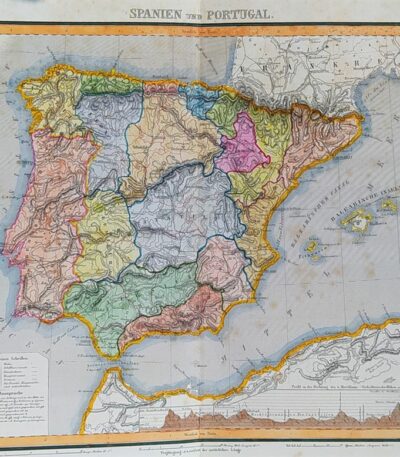
Map of Spain and Portugal, 1869
60,00 €Map of Spain and Portugal It is a watercolour lithograph from 1869, which represents the Iberian territories in detail.
This map is taken from the volume Hand – Und Schulatlas uber alle Theile Der Erde and is presented with an editorial twist.
- Sheet size: mm. 437×347
- Support: Strong paper
- Condition: Excellent condition

Map of Spain and Portugal, 1869
60,00 €Map of Spain and Portugal è una litografia colorata all’acquarello realizzata nel 1869.
This map, part of the Hand und Schulatlas di Dr. V.F. Klun, offre una rappresentazione dettagliata della penisola iberica.
- Map dimensions: cm. 34×28 circa
- Sheet size: cm. 44×35 circa
- Support: Strong paper
- Condition: Excellent condition

Mappa della Svezia, 1869
60,00 €Mappa della Svezia è una litografia acquarellata realizzata nel 1869, che rappresenta la Svezia, la Norvegia e la Danimarca.
This map is taken from the volume Hand – Und Schulatlas uber alle Theile Der Erde e presenta un retro bianco con una piega editoriale.
- Sheet size: mm. 437×347
- Technique: Lithography
- Condition: Excellent
- Support: Strong paper

Map of Sweden, Russia, Germany, Poland and Denmark, 1760
40,00 €A new and compleat map of the parts of Sweden, Russia, Germany, Poland and Denmark, bordering on the Baltick Sea è una mappa storica pubblicata nel 1760 da J. Hinton a Newgate Street, Londra.
L’opera raffigura con dettagliata precisione le regioni che circondano il Mar Baltico, includendo Svezia, Russia, Germania, Polonia e Danimarca, e rappresenta un esempio significativo della cartografia settecentesca britannica, realizzata in un periodo di crescente interesse per l’espansione geografica e politica.
- Era: 18th century
- Technique: Copper engraving
- Dimensions: Grandi (28×34 cm, senza margini)
- Support: Paper
- Condition: Buone (nota: assenza della cornice laterale)
Questa mappa è un’importante testimonianza storica che combina arte e scienza, rappresentando un’opportunità preziosa per collezionisti e studiosi di cartografia.
Map of Switzerland, Cosmographia, 1588
Mappa della Svizzera, Cosmographia è un’incisione realizzata nel 1588 da Sebastian Munster.
Questa mappa, pubblicata nel celebre volume Cosmography, è una delle opere più popolari del XVI secolo.
- Sheet size: cm. 33×20 approx.
- Engraving size: cm. 15×15 circa
- Technique: Xilografia con scritta in gotico antico
- Support: Handmade laid paper
- Condition: Excellent state of preservation
Questa illustrazione presenta diverse città svizzere, tra cui Thun, Berna, Newburg e Losanna.

Map of Türkiye, 1821
25,00 €Map of Türkiye, 1821 It is a small geographical map representing Turkey in Europe, made in 1821.
This copper engraving has been watercoloured and has a white backing.
- Sheet size: cm. 13×15 approx.
- Map dimensions: cm. 9×9 approx.
- Support: Paper
- Condition: Excellent

Map of Türkiye, Asia, 1821
25,00 €Map of Türkiye, Asia It is a watercolour copper engraving dating back to 1821.
This small geographical map measures approximately 9x9 cm on a sheet of 13x15 cm.
- Back: White
- Taken from: French text from 1821
- Condition: Excellent condition

Map of the islands of America, 1821
25,00 €Mappa delle isole dell’America è un’incisione in rame acquarellata realizzata nel 1821.
Questa piccola carta geografica, di dimensioni contenute, offre una rappresentazione dettagliata delle isole americane, ed è tratta da un testo francese dell’epoca.
- Sheet size: cm. 13×15 approx.
- Engraving size: cm. 9×9 approx.
- Support: Paper
- Condition: Excellent state of preservation
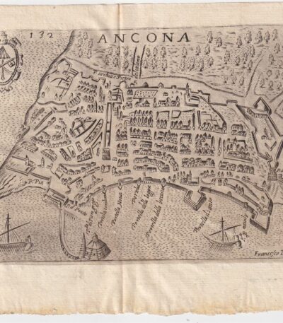
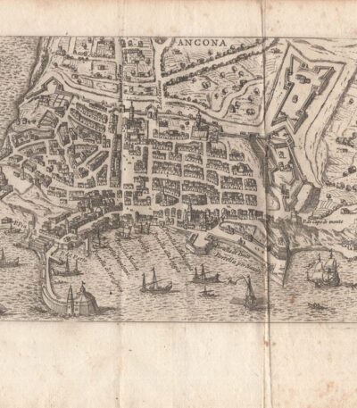
Map of Ancona, Scotus, 1659
90,00 €Map of Ancona it is a copper engraving made in 1659 by Francesco Scoto.
This map is part of the work Itinerary of Italy, published in Padua by Matteo Cadorino.
- Sheet size: cm. 16×20 approx.
- Engraving size: cm. 12×17 approx.
- Support: Light laid paper
- Condition: Excellent state of preservation
- Fold: Editorial fold
Map of Ancona, Scotus, 1761
90,00 €Map of Ancona it is an engraving made by Francesco Scotto in 1761.
This map is taken from the work Itinerary of Italy, published in Rome in 1761, at the expense of Fausto Amidei, Book Merchant.
- Sheet size: cm. 18×23 approx.
- Engraving size: cm. 12×18 approx.
- Support: Laid paper
- Condition: Excellent state of preservation
- Characteristic: Editorial fold

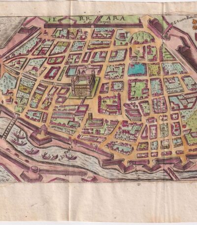
Mappa di Bologna, 1707
50,00 €Incisione realizzata nel 1707, utilizzando la tecnica dell’acquaforte su rame.
Questa opera è stampata su carta leggera vergellata con retro bianco.
It is part of the volume Les delices de l’Italie di De Rogissart, edizione francese, pubblicata a Parigi nel 1707.
- Sheet size: cm. 16×17 circa
- Dimensioni dell’incisione: cm. 12×14 circa
- Support: Laid paper
- Condition: Excellent condition.

Mappa di Bologna, Scoto, 1761
90,00 €Mappa di Bologna it is a copper engraving made by Francesco Scotto in 1761.
This map is taken from the work Itinerary of Italy, published in Rome by Fausto Amidei, Book Merchant.
- Sheet size: cm. 18×23 approx.
- Engraving size: cm. 12×18 approx.
- Support: Laid paper
- Condition: Excellent condition
- Folds: Editorials

Map of Brescia, 1873
25,00 €Map of Brescia It is a copper engraving made in 1873.
This map is taken from the Guide in Italy, edited by Cav. PE Sacchi and published by the Artaria company of Milan.
On the back there is a white background, while on the side there is a legend of the most important sites of the city.
- Sheet size: cm. 15.5x9.5 approx.
- Condition: Excellent condition
- Support: Paper

Map of Civitavecchia, Scotus, 1761
90,00 €Mappa di Civitavecchia it is a copper engraving made by Francesco Scotto in 1761.
This map is taken from the work Itinerary of Italy, pubblicata a Roma da Fausto Amidei, mercante di libri.
- Sheet size: cm. 18×23 approx.
- Engraving size: cm. 12×18 approx.
- Support: Laid paper
- Condition: Excellent state of preservation
- Folds: Present

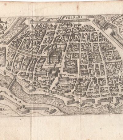
Map of Ferrara, 1707
50,00 €Incisione realizzata nel 1707, utilizzando la tecnica dell’acquaforte su rame.
Questa opera è stampata su carta leggera vergellata con retro bianco.
It is part of the volume Les delices de l’Italie di De Rogissart, edizione francese, pubblicata a Parigi nel 1707.
- Sheet size: cm. 16×17 circa
- Dimensioni dell’incisione: cm. 12×14 circa
- Support: Laid paper
- Condition: Excellent condition.
Map of Ferrara, Scotus, 1659
120,00 €Mappa di Ferrara it is a watercolour copper engraving made by Francesco Scoto in 1659.
This map is part of the work Itinerary of Italy, published in Padua by Matteo Cadorino.
- Sheet size: cm. 16×20 approx.
- Engraving size: cm. 12×17 approx.
- Support: Light laid paper
- Condition: Excellent state of preservation
- Fold: Editorale
Map of Ferrara, Scotus, 1761
90,00 €Mappa di Ferrara It is a copper engraving made in 1761 from Francesco Scotto.
This map is taken from the work Itinerary of Italy, pubblicata a Roma da Fausto Amidei, mercante di libri.
- Sheet size: cm. 18×23 approx.
- Engraving size: cm. 12×18 approx.
- Support: Laid paper
- Condition: Excellent condition
- Folds: Editorials

Mappa di Firenze, 1707
50,00 €Incisione realizzata nel 1707, utilizzando la tecnica dell’acquaforte su rame.
Questa opera è stampata su carta leggera vergellata con retro bianco.
It is part of the volume Les delices de l’Italie di De Rogissart, edizione francese, pubblicata a Parigi nel 1707.
- Sheet size: cm. 16×17 circa
- Dimensioni dell’incisione: cm. 12×14 circa
- Support: Laid paper
- Condition: Excellent condition.
Mappa di Firenze, 1873
30,00 €Mappa di Firenze è un’incisione su rame realizzata da P. Allodi nel 1873.
This map is taken from the publication Guide in Italy, curata dal cav. P.E. Sacchi e stampata dalla ditta Artaria di Milano.
- Sheet size: cm. 15.5x20.5 approx.
- Support: Paper
- Condition: Excellent condition
- Notes: White back with legend of the most important sites of the city, features an editorial fold.

Mappa di Firenze, Scoto, 1761
90,00 €Mappa di Firenze it is a copper engraving made in 1761 by Francesco Scotto.
This map is part of the work Itinerary of Italy, pubblicata a Roma da Fausto Amidei.
- Sheet size: cm. 18×23 approx.
- Engraving size: cm. 12×18 approx.
- Support: Laid paper
- Condition: Buone, con pieghe editoriali e riparazioni con carta al verso

Mappa di Genova, 1873
30,00 €Mappa di Genova It is a copper engraving made in 1873 da P. Allodi.
Questa mappa è parte della pubblicazione Guide in Italy, curata dal cav. P.E. Sacchi e stampata dalla ditta Artaria di Milano.
- Sheet size: cm. 15.5x20.5 approx.
- Support: Paper
- Condition: Excellent condition
- Characteristics: Retro bianco con legenda dei siti più importanti della città, presenta una piega editoriale

Mappa di Genova, de Rogissart, 1707
50,00 €Incisione realizzata nel 1707, utilizzando la tecnica dell’acquaforte su rame.
Questa opera è stampata su carta leggera vergellata con retro bianco.
It is part of the volume Les delices de l’Italie di De Rogissart, edizione francese, pubblicata a Parigi nel 1707.
- Sheet size: cm. 19×16 circa
- Dimensioni dell’incisione: cm. 10×14 circa
- Support: Laid paper
- Condition: Ottime condizioni. Due pieghe editoriali.

Map of Livorno, Scoto, 1761
90,00 €Map of Livorno It is a copper engraving made in 1761 by Francesco Scotto.
This map is part of the work Itinerary of Italy, published in Rome at the expense of Fausto Amidei, Book Merchant.
- Sheet size: cm. 18×23 approx.
- Engraving size: cm. 12×18 approx.
- Support: Laid paper
- Condition: Good, with editorial folds and paper repair on the back
